Natural Resources
Conservation Service
Ecological site R061XY122WY
Loamy-West (16-20" PZ)
Accessed: 04/20/2024
General information
Provisional. A provisional ecological site description has undergone quality control and quality assurance review. It contains a working state and transition model and enough information to identify the ecological site.
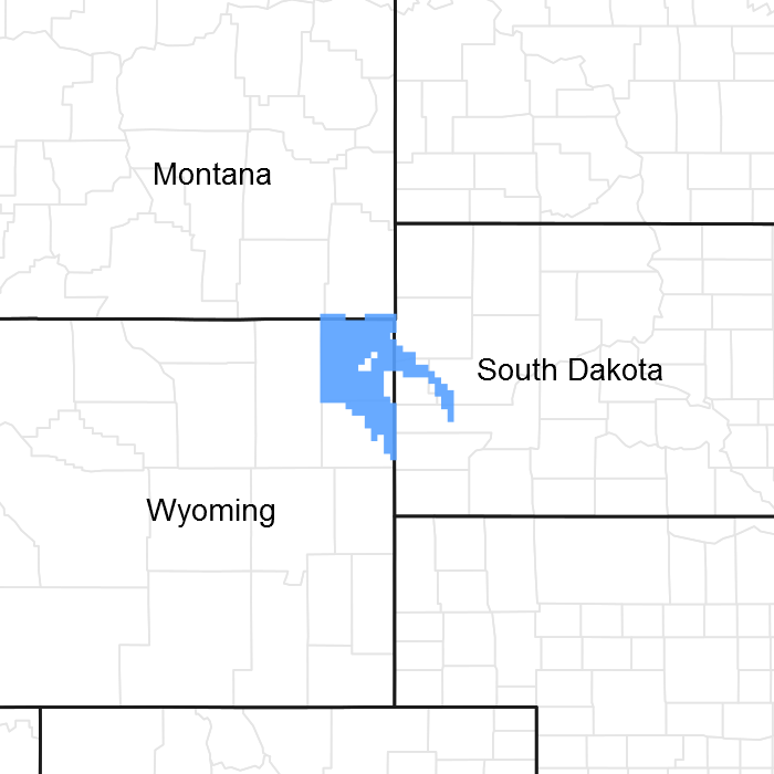
Figure 1. Mapped extent
Areas shown in blue indicate the maximum mapped extent of this ecological site. Other ecological sites likely occur within the highlighted areas. It is also possible for this ecological site to occur outside of highlighted areas if detailed soil survey has not been completed or recently updated.
Associated sites
| R061XY104WY |
Clayey-West (16-20" PZ) |
|---|---|
| R061XY128WY |
Lowland (LL) 15-19" Precipitation Zone, Black Hills |
| R061XY130WY |
Overflow (Ov) 15-19" Precipitation Zone, Black Hills |
| R061XY150WY |
Sandy (Sy) 15-19" Precipitation Zone, Black Hills |
| R061XY162WY |
Shallow Loamy-West (16-20" PZ) |
Similar sites
| R058BY222WY |
Loamy (Ly) 15-17” PZ Loamy 15-17" Northern Plains P.Z. has lower production. |
|---|
Table 1. Dominant plant species
| Tree |
Not specified |
|---|---|
| Shrub |
Not specified |
| Herbaceous |
Not specified |
Physiographic features
This site occurs on land nearly level, up to 50% slopes.
Table 2. Representative physiographic features
| Landforms |
(1)
Hill
(2) Alluvial fan (3) Stream terrace |
|---|---|
| Flooding frequency | None |
| Ponding frequency | None |
| Elevation | 3,500 – 5,000 ft |
| Slope | 6% |
| Ponding depth |
Not specified |
| Water table depth | 60 in |
| Aspect | Aspect is not a significant factor |
Climatic features
Annual precipitation ranges from 15-19 inches per year. Wide fluctuations may occur in yearly precipitation and result in more dry years than those with more than normal precipitation. Temperatures show a wide range between summer and winter and between daily maximums and minimums. This is predominantly due to the high elevation and dry air, which permits rapid incoming and outgoing radiation. Cold air outbreaks in winter move rapidly from northwest to southeast and account for extreme minimum temperatures. Extreme storms may occur during the winter, but most severely affect ranch operations during late winter and spring.
Strong winds are less frequent than over other areas of Wyoming. Occasional storms, however, can bring brief periods of high winds with gusts exceeding 50 mph.
Growth of native cool season plants begins about April 1 and continues to about July 1. Native warm season plants begin about May 15 and continue to about August 15. Fall green-up may occur in September and last through October.
The following information is from the “Devils Tower 2” climate station:
Minimum Maximum 5 yrs. out of 10 between
Frost-free period (days) (32°F): 58 93 June 6 – September 7
Freeze-free period (days) (28°F): 95 125 May 18 – September 20
Annual Precipitation (inches): 14.81 20.17
Mean annual precipitation: 17.66 inches
Mean annual air temperature: 44.4 F (28.6 F Avg. Min. to 60.1 F Avg. Max.)
For detailed information visit the Natural Resources Conservation Service National Water and Climate Center at http://www.wcc.nrcs.usda.gov/ website. Other climate station(s) representative of this precipitation zone include ”Hulett” and “Sundance”
Table 3. Representative climatic features
| Frost-free period (average) | 93 days |
|---|---|
| Freeze-free period (average) | 125 days |
| Precipitation total (average) | 20 in |
Influencing water features
Influencing Water Features
Wetland Description: System Subsystem Class Sub-class
None None None None None
Stream Type: None
Soil features
The soils of this site are deep to moderately deep (greater than 20" to bedrock), well-drained & moderately permeable. Layers of the soil most influential to the plant community vary from 3 to 6 inches thick. These layers consist of the A horizon with very fine sandy loam, loam, or silt loam texture and may also include the upper few inches of the B horizon with sandy clay loam, silty clay loam or clay loam texture.
Parent Material Kind: residuum and alluvium
Parent Material Origin: sandstone, unspecified
Surface Texture: loamy, silt loam, very fine sandy loam
Surface Texture Modifier: none is most common but gravelly or cobbly may occur
Subsurface Texture Group: loam
Surface Fragments < 3” (% Cover): 0
Surface Fragments > 3” (%Cover): typically 0, occasionally up to10
Subsurface Fragments < 3” (% Volume): typically 0, occasionally up to 20
Subsurface Fragments > 3” (% Volume): typically 0, occasionally up to 10
Minimum Maximum
Drainage Class: moderately well drained well drained
Permeability Class: moderately slow moderate
Depth (inches): 20 >60
Electrical Conductivity (mmhos/cm) <20”: 0 4
Sodium Absorption Ratio <20”: 0 5
Soil Reaction (1:1 Water) <20”: 7.8 8.4
Soil Reaction (0.1M CaCl2) <20”: NA NA
Available Water Capacity (inches) <30”: 2.1 5.5
Calcium Carbonate Equivalent (percent) <20”: 0 10
Table 4. Representative soil features
| Surface texture |
(1) Loam (2) Silt loam (3) Very fine sandy loam |
|---|---|
| Family particle size |
(1) Loamy |
| Drainage class | Moderately well drained to well drained |
| Permeability class | Moderately slow to moderate |
| Soil depth | 20 – 60 in |
| Surface fragment cover <=3" | Not specified |
| Surface fragment cover >3" | 10% |
| Available water capacity (0-40in) |
2.1 – 5.5 in |
| Calcium carbonate equivalent (0-40in) |
10% |
| Electrical conductivity (0-40in) |
4 mmhos/cm |
| Sodium adsorption ratio (0-40in) |
5 |
| Soil reaction (1:1 water) (0-40in) |
7.8 – 8.4 |
| Subsurface fragment volume <=3" (Depth not specified) |
20% |
| Subsurface fragment volume >3" (Depth not specified) |
10% |
Ecological dynamics
Ecological Dynamics of the Site:
As this site deteriorates because of a combination of frequent and severe grazing, species such as blue grama and big sagebrush will increase. Grasses such as green needlegrass, needleandthread, big bluestem, little bluestem and western wheatgrass will decrease in frequency and production.
Big sagebrush may become dominant on some areas with an absence of fire. Wildfires are actively controlled in recent times so chemical control using herbicides has replaced the historic role of fire on this site. Recently, prescribed burning has regained some popularity.
The site is resilient when sagebrush is removed if a healthy and vigorous stand of grass exists and is maintained. The exception to this is where the herbaceous component is severely degraded at the time of treatment, growing conditions are unfavorable after treatment, and/or recovery periods are inadequate.
The Historic Climax Plant Community (description follows the plant community diagram) has been determined by study of rangeland relic areas, or areas protected from excessive disturbance. Trends in plant communities going from heavily grazed areas to lightly grazed areas, seasonal use pastures, and historical accounts have also been used.
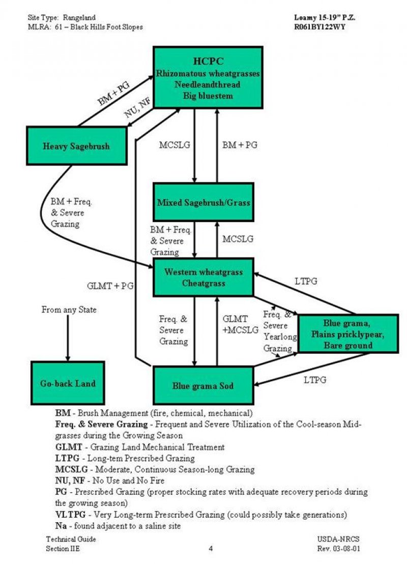
The following is a State and Transition Model Diagram that illustrates the common plant communities (states) that can occur on the site and the transitions between these communities. The ecological processes will be discussed in more detail in the plant community narratives following the diagram.
Plant Community Narratives
Following are the narratives for each of the described plant communities. These plant communities may not represent every possibility, but they probably are the most prevalent and repeatable plant communities. The plant composition tables shown above have been developed from the best available knowledge at the time of this revision. As more data is collected, some of these plant communities may be revised or removed, and new ones may be added. None of these plant communities should necessarily be thought of as “Desired Plant Communities”. According to the USDA NRCS National Range and Pasture Handbook, Desired Plant Communities (DPC’s) will be determined by the decision-makers and will meet minimum quality criteria established by the NRCS. The main purpose for including any description of a plant community here is to capture the current knowledge and experience at the time of this revision.
State and transition model
More interactive model formats are also available.
View Interactive Models
More interactive model formats are also available.
View Interactive Models
Click on state and transition labels to scroll to the respective text
State 1 submodel, plant communities
State 2 submodel, plant communities
State 3 submodel, plant communities
State 4 submodel, plant communities
State 5 submodel, plant communities
State 6 submodel, plant communities
State 7 submodel, plant communities
State 1
Rhizomatous wheatgrasses needleandthread/Big bluestem
Community 1.1
Rhizomatous wheatgrasses needleandthread/Big bluestem
Rhizomatous Wheatgrasses/ Needleandthread/Big Bluestem Plant Community This plant community is the interpretive plant community for this site and is considered to be the Historic Climax Plant Community (HCPC). This plant community evolved with grazing by large herbivores and is well suited for grazing by domestic livestock. This plant community can be found on areas that are properly managed with grazing and/or prescribed burning, and on areas receiving occasional short periods of rest. The potential vegetation is about 75% grasses or grass-like plants, 15% forbs, and 10% woody plants. A mix of warm and cool season mid-grasses dominates the state. The major grasses include western wheatgrass, needleandthread, big bluestem, little bluestem, and green needlegrass. Other grasses occurring on the state include threadleaf sedge, Sandberg bluegrass, bluebunch wheatgrass, blue grama, and sideoats grama. A variety of forbs and half-shrubs also occur, as shown in the preceding table. Big sagebrush is a conspicuous element of this state, occurs in a mosaic pattern, and makes up 5 to 10% of the annual production. Plant diversity is high. The total annual production (air-dry weight) of this state is about 2200 lbs/acre, but it can range from about 1500 lbs/acre in unfavorable years to about 3000 lbs/acre in above average years. This plant community is extremely stable and well adapted to the Black Hills Foot Slopes climatic conditions. The diversity in plant species allows for high drought tolerance. This is a sustainable plant community (site/soil stability, watershed function, and biologic integrity). Transitions or pathways leading to other plant communities are as follows: • No use and no fire for 20 years or more will convert this plant community to the Heavy Sagebrush Plant Community. • Moderate, continuous season-long grazing will convert the plant community to the Mixed Sagebrush/Grass Plant Community. • When cropped annually and then abandoned without reseeding, the state is converted to the Go-back Land Plant Community.
Figure 2. Annual production by plant type (representative values) or group (midpoint values)
Figure 3. Plant community growth curve (percent production by month). WY1601, 15-19BL Upland sites.
| Jan | Feb | Mar | Apr | May | Jun | Jul | Aug | Sep | Oct | Nov | Dec |
|---|---|---|---|---|---|---|---|---|---|---|---|
| J | F | M | A | M | J | J | A | S | O | N | D |
| 5 | 20 | 40 | 15 | 5 | 10 | 5 |
State 2
Mixed sagebrush/grass
Community 2.1
Mixed sagebrush/grass
Mixed Sagebrush/Grass Plant Community Historically, this plant community evolved under grazing by bison and a low fire frequency. Currently, it is found under moderate, season-long grazing by livestock in the absence of fire or brush management. Big sagebrush is a significant component of this plant community. A mix of warm and cool-season grasses make up the majority of the understory with the balance made up of annual cool-season grasses, and miscellaneous forbs. Dominant grasses include needleandthread, western wheatgrass, little bluestem and green needlegrass. Grasses of secondary importance include blue grama, prairie junegrass, and Sandberg bluegrass. Forbs commonly found in this plant community include plains wallflower, hairy goldaster, slimflower scurfpea, and scarlet globemallow. Sagebrush canopy ranges from 20% to 30%. Fringed sagewort is commonly found. Plains pricklypear can also occur. When compared to the Historic Climax Plant Community, sagebrush and blue grama have increased. Production of cool-season grasses, particularly green needlegrass, has been reduced. The cool-season mid-grasses are protected by the sagebrush canopy, but this protection makes them unavailable for grazing. Cheatgrass (downy brome) has invaded the state. The overstory of sagebrush and understory of grass and forbs provide a diverse plant community that will support domestic livestock and wildlife such as mule deer and antelope. The total annual production (air-dry weight) of this state is about 1600 pounds per acre, but it can range from about 900 lbs/acre in unfavorable years to about 2500 lbs/acre in above average years. This plant community is resistant to change. A significant reduction of big sagebrush can only be accomplished through fire or brush management. The herbaceous species present are well adapted to grazing; however, species composition can be altered through long-term overgrazing. If the herbaceous component is intact, it tends to be resilient if the disturbance is not long-term. Transitions or pathways leading to other plant communities are as follows: • Brush management (chemical, fire, or mechanical), followed by prescribed grazing, will convert this plant community to the Rhizomatous wheatgrasses/ Needleandthread/ Big Bluestem Plant Community. The probability of this occurring is high. When prescribed fire is used, sufficient fine fuels will need to be present. This may require deferment from grazing prior to treatment. Post management is critical to ensure success. This can range from two or more years of rest to partial growing season deferment, depending on the condition of the understory at the time of treatment and the growing conditions following treatment. • Brush management, followed by frequent and severe grazing, will convert the plant community to the Western Wheatgrass/Cheatgrass Plant Community. The probability of this occurring is high. If bare areas exist after treatment, along with no recovery periods from grazing, cheatgrass will invade and plants not as resistant to grazing, such as green needlegrass, will be reduced.
Figure 4. Plant community growth curve (percent production by month). WY1601, 15-19BL Upland sites.
| Jan | Feb | Mar | Apr | May | Jun | Jul | Aug | Sep | Oct | Nov | Dec |
|---|---|---|---|---|---|---|---|---|---|---|---|
| J | F | M | A | M | J | J | A | S | O | N | D |
| 5 | 20 | 40 | 15 | 5 | 10 | 5 |
State 3
Heavy Sagebrush
Community 3.1
Heavy Sagebrush
Heavy Sagebrush Plant Community This plant community is the result of long-term protection from grazing and fire. Big sagebrush eventually dominates this plant community with canopy cover often exceeding 60%. At first, excessive litter builds up shading out some of the grasses and forbs. Other plants become decadent with low vigor. Bunch grasses often develop dead centers. Eventually, the interspaces between plants increase in size leaving more soil surface exposed. Organic matter oxidizes in the air rather than being incorporated into the soil. The dominant plants tend to be somewhat similar to those found in the Historic Climax Plant Community. Weedy species, cool-season grasses, and sedges have increased. Blue grama has decreased. Rodent activity has resulted in an increase in soil disturbance. Cactus and sageworts often increase. Noxious weeds such as Dalmatian toadflax, leafy spurge, or Canada thistle may invade the state if a seed source is present. Plant diversity is moderate to high. The total annual production (air-dry weight) of this state is about 1200 pounds per acre, but it can range from about 900 lbs/acre in unfavorable years to about 2400 lbs/acre in above average years. This plant community is not resistant to change and is more vulnerable to severe disturbance than the HCPC. The introduction of grazing or fire quickly changes the plant community. Soil erosion is accelerated because of increased bare ground. Water flow patterns and pedestaling are obvious. Infiltration is reduced and runoff is increased. Transitions or pathways leading to other plant communities are as follows: • Brush management, followed by prescribed grazing, will return this plant community to at or near the Rhizomatous Wheatgrasses/ Needleandthread/ Big Bluestem Plant Community. • Brush management, followed by frequent and severe grazing, will convert the plant community to the Western Wheatgrass/Cheatgrass Plant Community. The probability of this occurring is high because of the amount of bare ground exposed to cheatgrass invasion.
Figure 5. Plant community growth curve (percent production by month). WY1601, 15-19BL Upland sites.
| Jan | Feb | Mar | Apr | May | Jun | Jul | Aug | Sep | Oct | Nov | Dec |
|---|---|---|---|---|---|---|---|---|---|---|---|
| J | F | M | A | M | J | J | A | S | O | N | D |
| 5 | 20 | 40 | 15 | 5 | 10 | 5 |
State 4
Western wheatgrass/ cheatgrass
Community 4.1
Western wheatgrass/ cheatgrass
Western Wheatgrass/Cheatgrass Plant Community This plant community is created when the Mixed Sagebrush/Grass Plant Community or the Heavy Sagebrush Plant Community is subjected to fire or brush management not followed by prescribed grazing. Rhizomatous wheatgrasses and annuals will dominate the state. Compared to the HCPC, cheatgrass has invaded with western wheatgrass and thickspike wheatgrass maintaining at a similar or slightly higher level. Virtually all other cool-season mid-grasses are severely decreased. Blue grama is the same or slightly less than found in the HCPC. Plant diversity is low. The total annual production (air-dry weight) of this state is about 1100 pounds per acre, but it can range from about 800 lbs/acre in unfavorable years to about 1500 lbs/acre in above average years. This plant community is relatively stable with the rhizomatous wheatgrasses being somewhat resistant to overgrazing and the cheatgrass effectively competing against the establishment of perennial cool-season grasses. An increase in bare ground reduces water infiltration and increases soil erosion. The watershed is usually functioning. The biotic integrity is reduced by the lack of diversity in the plant community. Transitions or pathways leading to other plant communities are as follows: • Moderate continuous season-long grazing will eventually return this plant community to the Mixed Sagebrush/Grass Plant Community. • Frequent and severe grazing will convert this plant community to Blue Grama Sod Plant Community. • Frequent and severe yearlong grazing will convert this plant community to Blue grama, Plains Pricklypear/ Bare Ground Plant Community. • Long-term, prescribed grazing will eventually return this plant community to at or near the Rhizomatous Wheatgrasses/ Needleandthread/ Big Bluestem Plant Community.
Figure 6. Plant community growth curve (percent production by month). WY1601, 15-19BL Upland sites.
| Jan | Feb | Mar | Apr | May | Jun | Jul | Aug | Sep | Oct | Nov | Dec |
|---|---|---|---|---|---|---|---|---|---|---|---|
| J | F | M | A | M | J | J | A | S | O | N | D |
| 5 | 20 | 40 | 15 | 5 | 10 | 5 |
State 5
Blue grama sod
Community 5.1
Blue grama sod
Blue Grama Sod Plant Community This plant community is the result of frequent and severe grazing during the growing season of the cool-season mid-grasses. A dense sod of blue grama dominates. Pricklypear cactus can become dense enough so that livestock cannot graze forage growing within the cactus clumps. When compared to the Historic Climax Plant Community, blue grama and threadleaf sedge have increased. All cool-season mid-grasses and forbs have been greatly reduced. Plant diversity is extremely low. The total annual production (air-dry weight) of this state is about 800 pounds per acre, but it can range from about 450 lbs/acre in unfavorable years to about 1100 lbs/acre in above average years. This sod bound plant community is very resistant to water infiltration. While this sod protects the state itself, off-site areas are affected by excessive runoff that can cause gully erosion. This sod is very resistant to change and may require grazing land mechanical treatment, such as chiseling, to return the cool-season grass component. Transitions or pathways leading to other plant communities are as follows: • Grazing land mechanical treatment (chiseling, etc.) and pricklypear cactus control (if needed), followed by prescribed grazing, will return this plant community to near Historic Climax Plant Community condition. • Grazing land mechanical treatment, followed by moderate continuous season-long grazing, will convert this plant community to the Western Wheatgrass/Cheatgrass Plant Community. • Frequent and severe yearlong grazing will eventually convert this state to the Blue Grama/ Plains Pricklypear/ Bare Ground Plant Community.
Figure 7. Plant community growth curve (percent production by month). WY1601, 15-19BL Upland sites.
| Jan | Feb | Mar | Apr | May | Jun | Jul | Aug | Sep | Oct | Nov | Dec |
|---|---|---|---|---|---|---|---|---|---|---|---|
| J | F | M | A | M | J | J | A | S | O | N | D |
| 5 | 20 | 40 | 15 | 5 | 10 | 5 |
State 6
blue grama/plains pricklypear/bare ground
Community 6.1
blue grama/plains pricklypear/bare ground
Blue Grama/ Plains Pricklypear/ Bare Ground Plant Community This plant community is the result of frequent and severe yearlong grazing over the long-term. Perennial plants are decreased. Cheatgrass, annual weeds, and bare ground have increased. Plains pricklypear has increased, rendering much of the forage unusable by livestock. This plant community is highly variable depending on the severity, frequency, and duration of the grazing and also the condition of the plant community when this level of grazing began. Virtually all plants not resistant to overgrazing may have been eliminated. Dominant plants may include blue grama, threeawns, annuals, and rhizomatous wheatgrasses to a lesser degree. Perennial plant diversity is low. The total annual production (air-dry weight) of this state is about 600 pounds per acre, but it can range from about 400 lbs/acre in unfavorable years to about 800lbs/acre in above average years. This state is unhealthy and subject to increased erosion. Runoff is high on these states due to the sod nature of blue grama and bare ground. Transitions or pathways leading to other plant communities are as follows: • Long-term prescribed grazing will convert this plant community initially to the Blue Grama Sod Plant Community, when the state is dominated by blue grama sod at the time of treatment. • Long-term prescribed grazing will convert this plant community to the Western Wheatgrass /Cheatgrass Plant Community, when the state has large amounts of cheatgrass, annual weeds, and bare ground at the time of treatment. Control of plains pricklypear cactus may be necessary. Reseeding areas with native plant species and proper grazing management may be necessary to accelerate recovery where few desirable plants remain.
Figure 8. Plant community growth curve (percent production by month). WY1601, 15-19BL Upland sites.
| Jan | Feb | Mar | Apr | May | Jun | Jul | Aug | Sep | Oct | Nov | Dec |
|---|---|---|---|---|---|---|---|---|---|---|---|
| J | F | M | A | M | J | J | A | S | O | N | D |
| 5 | 20 | 40 | 15 | 5 | 10 | 5 |
State 7
Go-back Land
Community 7.1
Go-back Land
Go-back Land Plant Community This plant community occurs on land that has been cropped annually in the past and then abandoned without reseeding. Natural succession has resulted in a plant community dominated by varying combinations of threeawns, cheatgrass, blue grama, Sandberg bluegrass, and some rhizomatous wheatgrasses. Forage production is low since grasses such as threeawns and cheatgrass are not used efficiently by livestock. The total annual production (air-dry weight) of this state is about 800 pounds per acre, but it can range from about 600 lbs/acre in unfavorable years to about 1200 lbs/acre in above average years. Growth curve description: Too variable to estimate The potential for accelerated erosion can be highly variable depending on amount of bare ground present. Biological diversity is low. Transitions or pathways leading to other plant communities are as follows: • Prescribed grazing may be used to increase desirable native cool-season grass production. It is usually difficult to return to near Historic Climax Plant Community condition in a timely manner because of past soil loss. • Grazing land mechanical treatment (i.e., chiseling) may improve forage production where significant rhizomatous wheatgrass is present to respond. Where there is a lack of perennial grasses, reseeding to tame or native species may be necessary to return these lands to production in the form of pastureland. These pastures are normally seeded to crested wheatgrass, pubescent wheatgrass, or Russian wildrye. They require considerable investment to establish and have a variable life expectancy. They do produce up to 50% more than native range, but their value as forage is somewhat limited due to the single species usually seeded. In some cases, the single species or certain groups of species (e.g., wheatgrasses) may be more vulnerable to infestation by associated insects and/or diseases (e.g., black grass bugs).
Additional community tables
Table 5. Community 1.1 plant community composition
| Group | Common name | Symbol | Scientific name | Annual production (lb/acre) | Foliar cover (%) | |
|---|---|---|---|---|---|---|
|
Grass/Grasslike
|
||||||
| 1 | 220–550 | |||||
| thickspike wheatgrass | ELLAL | Elymus lanceolatus ssp. lanceolatus | 220–550 | – | ||
| western wheatgrass | PASM | Pascopyrum smithii | 220–550 | – | ||
| 2 | 220–550 | |||||
| green needlegrass | NAVI4 | Nassella viridula | 220–550 | – | ||
| 3 | 220–550 | |||||
| Columbia needlegrass | ACNE9 | Achnatherum nelsonii | 220–550 | – | ||
| 4 | 220–550 | |||||
| Richardson's needlegrass | ACRI8 | Achnatherum richardsonii | 220–550 | – | ||
| 5 | 220–330 | |||||
| needle and thread | HECO26 | Hesperostipa comata | 220–330 | – | ||
| 6 | 110–220 | |||||
| blue wildrye | ELGL | Elymus glaucus | 110–220 | – | ||
| 7 | 110–220 | |||||
| sideoats grama | BOCU | Bouteloua curtipendula | 110–220 | – | ||
| 8 | 110–220 | |||||
| blue grama | BOGR2 | Bouteloua gracilis | 110–220 | – | ||
| 9 | 110–220 | |||||
| Cusick's bluegrass | POCU3 | Poa cusickii | 110–220 | – | ||
| 10 | 220–550 | |||||
| Grass, perennial | 2GP | Grass, perennial | 0–110 | – | ||
| big bluestem | ANGE | Andropogon gerardii | 0–110 | – | ||
| Pumpelly's brome | BRINP5 | Bromus inermis ssp. pumpellianus var. pumpellianus | 0–110 | – | ||
| threadleaf sedge | CAFI | Carex filifolia | 0–110 | – | ||
| plains reedgrass | CAMO | Calamagrostis montanensis | 0–110 | – | ||
| onespike danthonia | DAUN | Danthonia unispicata | 0–110 | – | ||
| bearded wheatgrass | ELCA11 | Elymus caninus | 0–110 | – | ||
| slender wheatgrass | ELTR7 | Elymus trachycaulus | 0–110 | – | ||
| prairie Junegrass | KOMA | Koeleria macrantha | 0–110 | – | ||
| spike fescue | LEKI2 | Leucopoa kingii | 0–110 | – | ||
| fowl bluegrass | POPA2 | Poa palustris | 0–110 | – | ||
| Sandberg bluegrass | POSE | Poa secunda | 0–110 | – | ||
| bluebunch wheatgrass | PSSP6 | Pseudoroegneria spicata | 0–110 | – | ||
| little bluestem | SCSC | Schizachyrium scoparium | 0–110 | – | ||
|
Forb
|
||||||
| 11 | 220–330 | |||||
| Forb, perennial | 2FP | Forb, perennial | 0–110 | – | ||
| prairie sagewort | ARFR4 | Artemisia frigida | 0–110 | – | ||
| white sagebrush | ARLU | Artemisia ludoviciana | 0–110 | – | ||
| prairie clover | DALEA | Dalea | 0–110 | – | ||
| fleabane | ERIGE2 | Erigeron | 0–110 | – | ||
| buckwheat | ERIOG | Eriogonum | 0–110 | – | ||
| desertparsley | LOMAT | Lomatium | 0–110 | – | ||
| bluebells | MERTE | Mertensia | 0–110 | – | ||
| silverleaf Indian breadroot | PEAR6 | Pediomelum argophyllum | 0–110 | – | ||
| beardtongue | PENST | Penstemon | 0–110 | – | ||
| upright prairie coneflower | RACO3 | Ratibida columnifera | 0–110 | – | ||
| American vetch | VIAM | Vicia americana | 0–110 | – | ||
| deathcamas | ZIGAD | Zigadenus | 0–110 | – | ||
|
Shrub/Vine
|
||||||
| 12 | 0–110 | |||||
| big sagebrush | ARTR2 | Artemisia tridentata | 0–110 | – | ||
| 13 | 0–110 | |||||
| Shrub (>.5m) | 2SHRUB | Shrub (>.5m) | 0–110 | – | ||
Interpretations
Animal community
Animal Community – Wildlife Interpretations
Rhizomatous Wheatgrasses/ Needleandthread/Big Bluestem Plant Community (HCPC): The predominance of grasses in this plant community favors grazers and mixed-feeders, such as bison, elk, and antelope. Suitable thermal and escape cover for deer may be limited due to the low quantities of woody plants. However, topographical variations could provide some escape cover. When found adjacent to sagebrush dominated states, this plant community may provide brood rearing/foraging areas for sage grouse, as well as lek sites. Other birds that would frequent this plant community include Western meadowlarks, horned larks, and golden eagles. Many grassland obligate small mammals would occur here.
Mixed Sagebrush/Grass Plant Community: The combination of an overstory of sagebrush and an understory of grasses and forbs provide a very diverse plant community for wildlife. The crowns of sagebrush tend to break up hard crusted snow on winter ranges, so mule deer and antelope may use this state for foraging and cover year-round, as would cottontail and jack rabbits. It provides important winter, nesting, brood-rearing, and foraging habitat for sage grouse. Brewer’s sparrows’ nest in big sagebrush plants and hosts of other nesting birds utilize stands in the 20-30% cover range.
Heavy Sagebrush Plant Community: This plant community can provide important winter foraging for elk, mule deer and antelope, as sagebrush can approach 15% protein and 40-60% digestibility during that time. This community provides excellent escape and thermal cover for large ungulates, as well as nesting and brood rearing habitat for sage grouse.
Western Wheatgrass/Cheatgrass Plant Community: This plant community may be useful for the same large grazers that would use the Historic Climax Plant Community. However, the plant community composition is less diverse, and thus, less apt to meet the seasonal needs of these animals. It may provide some foraging opportunities for sage grouse when it occurs proximal to woody cover. Good grasshopper habitat equals good foraging for birds.
Blue Grama Sod and Go-back Land Plant Communities: These communities provide limited foraging for antelope and other grazers. They may be used as a foraging site by sage grouse if proximal to woody cover and if the Historic Climax Plant Community or the Western Wheatgrass/Cheatgrass Plant Community is limited. Generally, these are not target plant communities for wildlife habitat management.
Blue Grama, Plains Pricklypear/Bare Ground Plant Community: Benefits to other wildlife are largely due to the subterranean structure created by the prairie dogs, not the sparse vegetation found on this plant community.
Animal Community – Grazing Interpretations
The following table lists suggested stocking rates for cattle under continuous season-long grazing under normal growing conditions. These are conservative estimates that should be used only as guidelines in the initial stages of the conservation planning process. Often, the current plant composition does not entirely match any particular plant community (as described in this ecological site description). Because of this, a field visit is recommended, in all cases, to document plant composition and production. More precise carrying capacity estimates should eventually be calculated using this information along with animal preference data, particularly when grazers other than cattle are involved. Under more intensive grazing management, improved harvest efficiencies can result in an increased carrying capacity. If distribution problems occur, stocking rates must be reduced to maintain plant health and vigor.
Plant Community Production Carrying Capacity*
(Lbs/acre) (AUM/acre)
Rhizomatous WG/ Needleandthread/ Big Bluestem 1500-3000 .6
Heavy Sagebrush 900-2400 .35
Mixed Sagebrush/Grass 900-2500 .5
Western Wheatgrass/Cheatgrass 800-1500 .35
Blue Grama Sod 450-750 .25
Blue grama/Plains Pricklypear/ Bare ground 400-800 .20
Go-back Land 800-1500 .25
* - Continuous, season-long grazing by cattle under average growing conditions.
Grazing by domestic livestock is one of the major income-producing industries in the area. Rangeland in this area may provide yearlong forage for cattle, sheep, or horses. During the dormant period, the forage for livestock use needs to be supplemented with protein because the quality does not meet minimum livestock requirements.
Hydrological functions
Water is the principal factor limiting forage production on this site. This site is dominated by soils in hydrologic group B and C, with localized areas in hydrologic group D. Infiltration and runoff potential for this site varies from moderate to high depending on soil hydrologic group and ground cover. In many cases, areas with greater than 75% ground cover have the greatest potential for high infiltration and lower runoff. An example of an exception would be where short-grasses form a strong sod and dominate the site. Areas where ground cover is less than 50% have the greatest potential to have reduced infiltration and higher runoff (refer to Section 4, NRCS National Engineering Handbook for runoff quantities and hydrologic curves).
Rills and gullies should not typically be present. Water flow patterns should be barely distinguishable if at all present. Pedestals are only slightly present in association with bunchgrasses such as bluebunch wheatgrass. Litter typically falls in place, and signs of movement are not common. Chemical and physical crusts are rare to non-existent. Cryptogamic crusts are present, but only cover 1-2% of the soil surface.
Recreational uses
This site provides hunting opportunities for upland game species. The wide variety of plants which bloom from spring until fall have an esthetic value that appeals to visitors.
Wood products
No appreciable wood products are present on the site.
Other products
none noted
Supporting information
Inventory data references
Information presented here has been derived from NRCS clipping data and other inventory data. Field observations from range trained personnel were also used. Other sources used as references include: USDA NRCS Water and Climate Center, USDA NRCS National Range and Pasture Handbook, and USDA NRCS Soil Surveys from various counties.
Contributors
G. Mitchell
Rangeland health reference sheet
Interpreting Indicators of Rangeland Health is a qualitative assessment protocol used to determine ecosystem condition based on benchmark characteristics described in the Reference Sheet. A suite of 17 (or more) indicators are typically considered in an assessment. The ecological site(s) representative of an assessment location must be known prior to applying the protocol and must be verified based on soils and climate. Current plant community cannot be used to identify the ecological site.
| Author(s)/participant(s) | |
|---|---|
| Contact for lead author | |
| Date | 04/01/2005 |
| Approved by | E. Bainter |
| Approval date | |
| Composition (Indicators 10 and 12) based on | Annual Production |
Indicators
-
Number and extent of rills:
Rills should not be present -
Presence of water flow patterns:
Barely observable -
Number and height of erosional pedestals or terracettes:
Essentially non-existent -
Bare ground from Ecological Site Description or other studies (rock, litter, lichen, moss, plant canopy are not bare ground):
Bare ground is 15-25% occurring in small areas throughout site -
Number of gullies and erosion associated with gullies:
Active gullies should not be present -
Extent of wind scoured, blowouts and/or depositional areas:
None -
Amount of litter movement (describe size and distance expected to travel):
Little to no plant litter movement. Plant litter remains in place and is not moved by erosional forces. -
Soil surface (top few mm) resistance to erosion (stability values are averages - most sites will show a range of values):
Plant cover and litter is at 75% or greater of soil surface and maintains soil surface integrity. Soil Stability class is anticipated to be 5 or greater. -
Soil surface structure and SOM content (include type of structure and A-horizon color and thickness):
Use Soil Series description for depth and color of A-horizon -
Effect of community phase composition (relative proportion of different functional groups) and spatial distribution on infiltration and runoff:
Grass canopy and basal cover should reduce raindrop impact and slow overland flow providing increased time for infiltration to occur. Healthy deep rooted native grasses enhance infiltration and reduce runoff. Infiltration is Moderate. -
Presence and thickness of compaction layer (usually none; describe soil profile features which may be mistaken for compaction on this site):
No compaction layer or soil surface crusting should be present. -
Functional/Structural Groups (list in order of descending dominance by above-ground annual-production or live foliar cover using symbols: >>, >, = to indicate much greater than, greater than, and equal to):
Dominant:
Sub-dominant:
Other:
Additional:
Mid-stature Bunch grasses > Mid-stature Rhizomatous grasses > Short stature grasses/grasslikes = Forbs > Shrubs -
Amount of plant mortality and decadence (include which functional groups are expected to show mortality or decadence):
Very Low -
Average percent litter cover (%) and depth ( in):
Average litter cover is 30-40% with depths of 0.25 to 1.0 inches -
Expected annual annual-production (this is TOTAL above-ground annual-production, not just forage annual-production):
2000 lbs/ac -
Potential invasive (including noxious) species (native and non-native). List species which BOTH characterize degraded states and have the potential to become a dominant or co-dominant species on the ecological site if their future establishment and growth is not actively controlled by management interventions. Species that become dominant for only one to several years (e.g., short-term response to drought or wildfire) are not invasive plants. Note that unlike other indicators, we are describing what is NOT expected in the reference state for the ecological site:
Blue grama, Big sagebrush, Annual bromes, Fringed sagewort, Prickly Pear, and Species found on Noxious Weed List -
Perennial plant reproductive capability:
All species are capable of reproducing
Print Options
Sections
Font
Other
The Ecosystem Dynamics Interpretive Tool is an information system framework developed by the USDA-ARS Jornada Experimental Range, USDA Natural Resources Conservation Service, and New Mexico State University.
Click on box and path labels to scroll to the respective text.