Natural Resources
Conservation Service
Ecological site AX001X03X001
Mesic Udic Riparian Forest
Last updated: 5/07/2024
Accessed: 11/24/2024
General information
Provisional. A provisional ecological site description has undergone quality control and quality assurance review. It contains a working state and transition model and enough information to identify the ecological site.
MLRA notes
Major Land Resource Area (MLRA): 001X–Northern Pacific Coast Range, Foothills, and Valleys
This long and narrow resource area stretches along the Pacific Border Province of the Pacific Mountain System in Oregon and Washington. The area is bounded by the Olympic Mountains on the north and the Klamath Mountains on the south. Most of the area consists of hills and low mountains with gentle to steep slopes. The parent materials are composed primarily of young Tertiary sedimentary rocks with some minor volcanic rocks. Glacial till and outwash deposits are found in the northern half of the area within Washington. In the far southern portion of the area, near the Klamath Mountains, the sedimentary rocks are older and some have been metamorphosed. The average annual precipitation ranges from 60 to 200 inches, increasing with elevation.
The dominant soil orders in this MLRA are Andisols, Inceptisols, and Ultisols. Soil depth ranges from shallow to very deep. While most soils in the area are well drained and occur on foothills, mountain slopes and ridges, floodplain and depressional soils can range from well drained to very poorly drained. Soil textures are typically medial, loamy, or clayey. The dominant soils in the area have a mesic or frigid soil temperature regime and a udic soil moisture regime; however, soils with an aquic soil moisture regime or cryic soil temperature regime do occur.
LRU notes
The Central Pacific Coast Range land resource unit (LRU 3) of MLRA 1 ranges from the Olympic Peninsula south into northern Oregon. LRU 3 is located south of the Olympic National Forest and extends to the Siletz River in Oregon. LRU 3 is bounded on the west by MLRA 4a Sitka Spruce Belt and MLRA 2 Willamette and Puget Sound Valleys to the east. Several major rivers have headwaters in this LRU or carved valleys through the landscape depositing more recent alluvium. These include the Chehalis, Columbia, Grays, Humptulips, Klaskanine, Nehalem, Satsop, Siletz, Willapa, Wilson, Wynoochee, and Yamhill Rivers.
Ecological site concept
This ecological site is found on the western Coast Range in the Pacific Northwest from southern Washington to northern Oregon. It is found in riparian corridors on stream terraces and flood plain steps on alluvial soils. It is located at low elevations (less than 1,000 ft.) with abundant precipitation. These areas are subject to stream overflow. Riparian ecological sites typically differ in topography, vegetation, geomorphology, and microclimate from the surrounding uplands of the forest ecosystem (Dwire, 2003).
The most common overstory species are bigleaf maple (Acer macrophyllum), red alder (Alnus rubra), cascara (Frangula purshiana), black cottonwood (Populus balsamifera spp. trichocarpa) and Oregon ash (Fraxinus latifolia). Conifers such as Douglas-fir (Pseudotsuga menziesii), western redcedar (Thuja plicata) and grand fir (Abies grandis) may occur in late seral sites or on terraces. Regeneration is restricted by canopy cover and often limited to gaps where sunlight is most available and mineral soil is exposed from scouring (Pabst, 1999). Understory species diversity is greatest near the streams as a result of erosion and deposition creating openings for opportunistic species as well as the abundance of microsites which create unique environments (Spies, et. al, 2002). Common understory species include Sitka willow (Salix sitchensis), shining willow (Salix lucida), salmonberry (Rubus spectabilis), stink currant (Ribes bracteosum), thimbleberry (Rubus parviflorus), elderberry (Sambucus racemosa), redosier dogwood (Cornus sericea), vine maple (Acer circinatum), western swordfern (Polystichum munitum), and Oregon oxalis (Oxalis oregana).
The most common natural disturbance is flooding, with the volume and longevity of the flooding determining the effect on the dynamics of the forest. Although wildfire is uncommon in this ecological site (greater than 450-year return interval) when it does occur, it may be stand replacing (Balian, 2005). Fallen trees with exposed root systems and the presence of large woody debris is common.
Associated sites
| AX001X03X003 |
Mesic Aquic Forest Ecological Site AX001X03X003, Mesic Aquic Forest is typically located adjacent to Ecological Site AX001X03X001, Mesic Udic Riparian Forest. Mesic Aquic Forest is located on alluvial terraces, moraines, and depressions. The site has poorly drained soils and is influenced by ponding. Mesic Udic Riparian Forest is found on flood plains and terraces. |
|---|
Similar sites
| AX001X02X001 |
Mesic Udic Riparian Forest Mesic Udic Riparian Forest ecological sites are similar but occur in different Land Resource Units. LRU 3 has a warmer climate and the presence of Oregon ash (Fraxinus latifolia) is a good indicator for LRU 3. |
|---|
Table 1. Dominant plant species
| Tree |
(1) Acer macrophyllum |
|---|---|
| Shrub |
(1) Rubus spectabilis |
| Herbaceous |
(1) Polystichum munitum |
Legacy ID
F001XC001OR
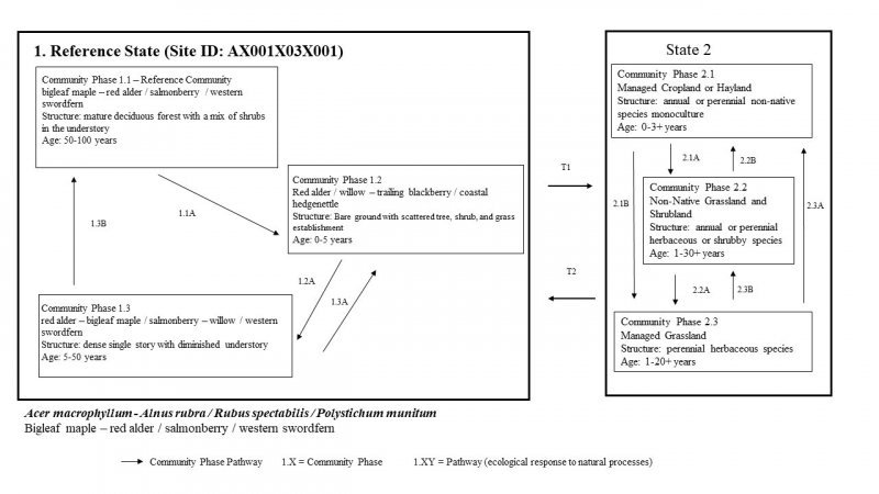
Click on box and path labels to scroll to the respective text.
