Natural Resources
Conservation Service
Ecological site AX001X03X201
Cryic Udic Meadow
Last updated: 1/23/2025
Accessed: 04/12/2025
General information
Provisional. A provisional ecological site description has undergone quality control and quality assurance review. It contains a working state and transition model and enough information to identify the ecological site.
MLRA notes
Major Land Resource Area (MLRA): 001X–Northern Pacific Coast Range, Foothills, and Valleys
This long and narrow resource area stretches along the Pacific Border Province of the Pacific Mountain System in Oregon and Washington. The area is bounded by the Olympic Mountains on the north and the Klamath Mountains on the south. Most of the area consists of hills and low mountains with gentle to steep slopes. The parent materials are composed primarily of young Tertiary sedimentary rocks with some minor volcanic rocks. Glacial till and outwash deposits are found in the northern half of the area within Washington. In the far southern portion of the area, near the Klamath Mountains, the sedimentary rocks are older and some have been metamorphosed. The average annual precipitation ranges from 60 to 200 inches, increasing with elevation.
The dominant soil orders in this MLRA are Andisols, Inceptisols, and Ultisols. Soil depth ranges from shallow to very deep. While most soils in the area are well drained and occur on foothills, mountain slopes and ridges, floodplain and depressional soils can range from well drained to very poorly drained. Soil textures are typically medial, loamy, or clayey. The dominant soils in the area have a mesic or frigid soil temperature regime and a udic soil moisture regime; however, soils with an aquic soil moisture regime or cryic soil temperature regime do occur.
LRU notes
The Central Pacific Coast Range land resource unit (LRU 3) of MLRA 1 ranges from the Olympic Peninsula south into northern Oregon. LRU 3 is located south of the Olympic National Forest and extends to the Siletz River in Oregon. LRU 3 is bounded on the west by MLRA 4a Sitka Spruce Belt and MLRA 2 Willamette and Puget Sound Valleys to the east. Several major rivers have headwaters in this LRU or carved valleys through the landscape depositing more recent alluvium. These include the Chehalis, Columbia, Grays, Humptulips, Klaskanine, Nehalem, Satsop, Siletz, Willapa, Wilson, Wynoochee, and Yamhill Rivers.
Ecological site concept
This ecological site is found on the western Coast Range in the Pacific Northwest from southern Washington to northern Oregon. It is located in open meadows on mountain shoulder slopes, back slopes, and summits. Elevations are greater than 2,500 feet with slopes ranging from 3 to 60 percent.
The climate has cool, moist summers and cold, wet winters. Mean annual precipitation ranges from 120 to 150 inches. Average annual temperatures range from 39 to 45 degrees F. Soils that support this ecological site occur in the cryic soil temperature regime and the udic soil moisture regime.
The site is predominantly comprised of low growing shrubs, forbs, and grass species. The meadows are adapted to harsh environmental conditions and short growing seasons. They endure strong winds, heavy snowpack, intense solar radiation, and freezing conditions. Plant production is directly related to the snow release date which can be highly variable from year to year. Additionally, drying winds on exposed slopes and ridges add to a moisture deficit through increased evapotranspiration during the growing season (Kuramoto, 1970). These effects are most pronounced on the exposed south and west slopes and ridgetops. As a result, plants are more sparsely located on the landscape and primarily drought tolerant species.
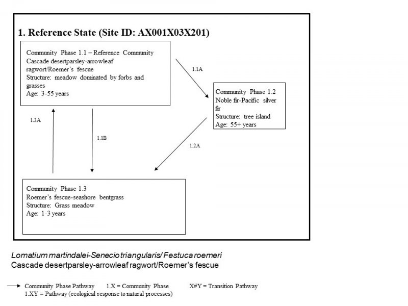
Snowpack is the primary abiotic driver that affects the length of the growing season, soil moisture availability, and susceptibility to wildfire. Historically, fire (anthropogenic and natural) was an important disturbance factor, suppressing the growth of encroaching conifers and retaining a forb, grass, and grass-like dominated parkland ecosystem (Hemstrom, 1982). This site is highly sensitive to small disturbances from soil compaction and damage to vegetation which may have significant impacts to the ecological integrity and resilience of the site. If there is a long period without disturbance, the site is subject to conifer encroachment including noble fir (Abies procera) and Pacific silver fir (Abies amabilis) creating tree islands.
The reference community may be most common, but it is likely that all community phases occur as a matrix across the landscape. Common plants include Cascade desertparsley (Lomatium martindalei), Pacific lupine (Lupinus lepidus), sulfur-flowered buckwheat (Erigonum umbellatum), toughleaf iris (Iris tenax), annual agoseris (Agoseris heterophylla), arrowleaf ragwort (Senecio triangularis), Columbia lily (Lilium columbianum), hookedspur violet (Viola adunca), Roemer’s fescue (Festuca roemeri), seashore bentgrass (Agrostis pallens), and California sedge (Carex californica).
Associated sites
| AX001X03X401 |
Cryic Udic Forest Cryic Udic Forest is located along the edges of Cryic Udic Meadow. The site is forested and located on mountain shoulders and summits. The most common overstory species include Pacific silver fir, noble fir, and western hemlock. The most common understory species include red huckleberry, salal, Oregon oxalis, and western swordfern. |
|---|
Similar sites
| AX001X03X201 |
Cryic Udic Meadow Cryic Udic Meadow is unique and does not share similar characteristics to other ecological sites. |
|---|
Table 1. Dominant plant species
| Tree |
Not specified |
|---|---|
| Shrub |
Not specified |
| Herbaceous |
(1) Lomatium martindalei |
Legacy ID
R001XC201OR
Click on box and path labels to scroll to the respective text.
