Natural Resources
Conservation Service
Ecological site AX001X03X205
Bog or Fen
Last updated: 1/23/2025
Accessed: 02/21/2026
General information
Provisional. A provisional ecological site description has undergone quality control and quality assurance review. It contains a working state and transition model and enough information to identify the ecological site.
MLRA notes
Major Land Resource Area (MLRA): 001X–Northern Pacific Coast Range, Foothills, and Valleys
This long and narrow resource area stretches along the Pacific Border Province of the Pacific Mountain System in Oregon and Washington. The area is bounded by the Olympic Mountains on the north and the Klamath Mountains on the south. Most of the area consists of hills and low mountains with gentle to steep slopes. The parent materials are composed primarily of young Tertiary sedimentary rocks with some minor volcanic rocks. Glacial till and outwash deposits are found in the northern half of the area within Washington. In the far southern portion of the area, near the Klamath Mountains, the sedimentary rocks are older and some have been metamorphosed. The average annual precipitation ranges from 60 to 200 inches, increasing with elevation.
The dominant soil orders in this MLRA are Andisols, Inceptisols, and Ultisols. Soil depth ranges from shallow to very deep. While most soils in the area are well drained and occur on foothills, mountain slopes and ridges, floodplain and depressional soils can range from well drained to very poorly drained. Soil textures are typically medial, loamy, or clayey. The dominant soils in the area have a mesic or frigid soil temperature regime and a udic soil moisture regime; however, soils with an aquic soil moisture regime or cryic soil temperature regime do occur.
LRU notes
The Central Pacific Coast Range land resource unit (LRU 3) of MLRA 1 ranges from the Olympic Peninsula south into northern Oregon. LRU 3 is located south of the Olympic National Forest and extends to the Siletz River in Oregon. LRU 3 is bounded on the west by MLRA 4a Sitka Spruce Belt and MLRA 2 Willamette and Puget Sound Valleys to the east. Several major rivers have headwaters in this LRU or carved valleys through the landscape depositing more recent alluvium. These include the Chehalis, Columbia, Grays, Humptulips, Klaskanine, Nehalem, Satsop, Siletz, Willapa, Wilson, Wynoochee, and Yamhill Rivers.
Ecological site concept
This ecological site is found on the western Coast Range in the Pacific Northwest from southern Washington to northern Oregon. It is located at low elevations (less than 1500 ft.) with abundant precipitation. The site is strongly influenced by physiography and hydrology. It includes both bogs and fens, which are unique ecosystems that impact carbon and hydrologic cycles and host rare and unique plant and animal species. Bogs commonly are in depressions and within closed hydrologic basins that primarily are influenced by snowpack and rainfall. Bogs do not have an outlet for water flow; therefore, they are a more acidic environment. Fens are influenced by groundwater and aquifer recharge and discharge (Patterson, 2007).
The duration and frequency of ponding directly influences the plant community. The vegetation is well adapted to abundant soil moisture, ponding, and soil acidity. Plant species vary depending on soil acidity and anaerobic conditions. The ecological sites located south of the Columbia River are dominated by western labrador tea (Ledum glandulosum) and bog Labrador tea (Ledum groenlandicum) is found on ecosites north of the Columbia River. Additional plant species include roundleaf sundew (Drosera rotundifolia), sedges (Carex spp.), and sphagnum moss (Sphagnum spp.). Shrubby species such as sweetgale (Myrica gale), salal (Gaultheria shallon), and small cranberry (Vaccinium oxycoccos) are on mounds and hummocks.
Table 1. Dominant plant species
| Tree |
Not specified |
|---|---|
| Shrub |
(1) Ledum |
| Herbaceous |
(1) Carex |
Legacy ID
R001XC205OR
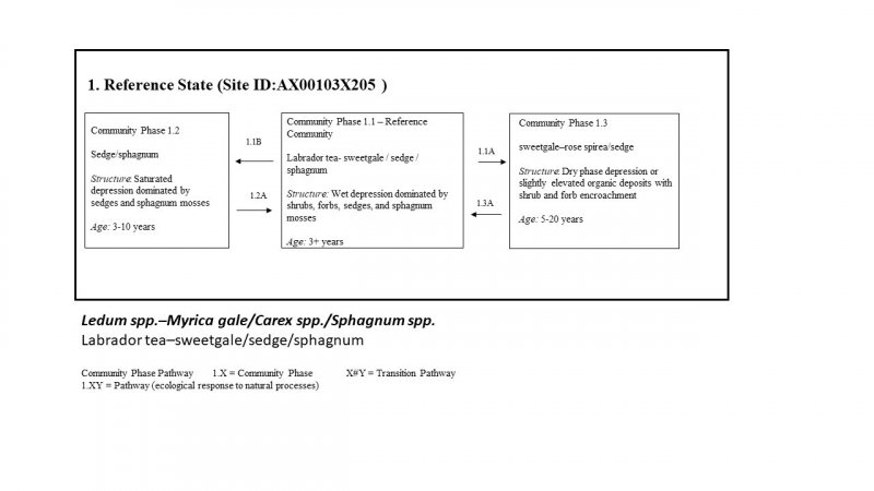
Click on box and path labels to scroll to the respective text.
