
Natural Resources
Conservation Service
Ecological site F004BX111CA
Redwood/western swordfern-redwood sorrel, floodplains and terraces, loam
Accessed: 12/06/2025
General information
Provisional. A provisional ecological site description has undergone quality control and quality assurance review. It contains a working state and transition model and enough information to identify the ecological site.
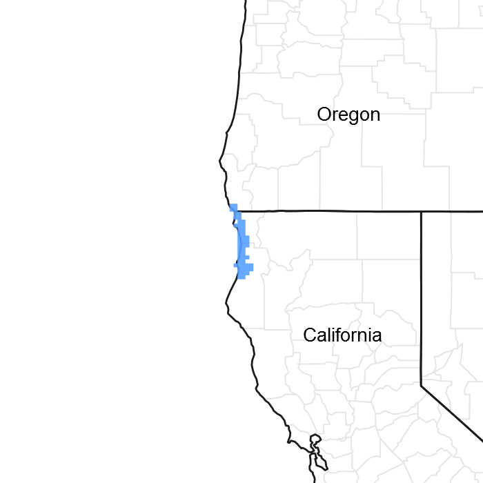
Figure 1. Mapped extent
Areas shown in blue indicate the maximum mapped extent of this ecological site. Other ecological sites likely occur within the highlighted areas. It is also possible for this ecological site to occur outside of highlighted areas if detailed soil survey has not been completed or recently updated.
Associated sites
| F004BX103CA |
Redwood-Douglas-fir/Pacific rhododendron, mountain slopes, sandstone, clay loam This site may be found in conjunction with F004BX111CA. |
|---|---|
| F004BX106CA |
Redwood/Douglas-fir/California huckleberry/western swordfern, hills, soft sandstone, very gravelly loam This site may be found in conjunction with F004BX111CA. |
| F004BX107CA |
Redwood/western swordfern, hills, soft sandstone, clay loam This site may be found in conjunction with F004BX111CA. |
| F004BX108CA |
Redwood, western swordfern, mountain slopes, sandstone and schist, clay loam This site may be found in conjunction with F004BX111CA. |
Similar sites
| F004BX107CA |
Redwood/western swordfern, hills, soft sandstone, clay loam F004BX107CA has similar in vegetation to F004BX111CA but is found on summits, shoulders and backslopes. |
|---|---|
| F004BX108CA |
Redwood, western swordfern, mountain slopes, sandstone and schist, clay loam F004BX108CA has similar vegetation to Foo4BX111CA but is found on summits and ridges. |
Table 1. Dominant plant species
| Tree |
(1) Sequoia sempervirens |
|---|---|
| Shrub |
Not specified |
| Herbaceous |
(1) Polystichum munitum |
Physiographic features
This ecological site is found throughout the survey area. It occurs on moist valley floors near creeks and rivers, as well as low terraces, alluvial fans, and fan remnants. Slopes are nearly level to gently sloping.
Table 2. Representative physiographic features
| Landforms |
(1)
Alluvial fan
(2) Terrace |
|---|---|
| Flooding duration | Brief (2 to 7 days) |
| Flooding frequency | Occasional |
| Ponding frequency | None |
| Elevation | 1 – 247 m |
| Slope | 0 – 9% |
| Ponding depth | 0 cm |
| Water table depth | 5 – 152 cm |
| Aspect | Aspect is not a significant factor |
Climatic features
The climate is humid with cool, foggy summers and cool, moist winters. Coastal influence limits the diurnal range in temperatures. Summertime temperatures range from 65 to 70 degrees F. The mean annual precipitation ranges from 60 to 75 inches and usually falls from October to May.
Table 3. Representative climatic features
| Frost-free period (average) | 300 days |
|---|---|
| Freeze-free period (average) | 300 days |
| Precipitation total (average) | 1,727 mm |
Figure 2. Monthly precipitation range
Figure 3. Monthly average minimum and maximum temperature
Figure 4. Annual precipitation pattern
Figure 5. Annual average temperature pattern
Influencing water features
The soil mapping conducted was order level III and is not fine enough to determine the Rosgen stream type.
Soil features
These very deep soils are very poorly drained to well-drained. They developed from alluvium derived from mixed sources, and are moderately to strongly acidic at 40 inches. They have a dominantly loamy subsurface rock content ranging from non-gravelly to gravelly.
CA605R mapunits and soil components include:
MU Component
171 Arlynda
171 Worswick
174 Bigtree
174 Mystery
253 Littleriver
Table 4. Representative soil features
| Surface texture |
(1) Loam (2) Silt loam (3) Very fine sand |
|---|---|
| Family particle size |
(1) Loamy |
| Drainage class | Poorly drained to well drained |
| Permeability class | Moderate to moderately rapid |
| Soil depth | 152 cm |
| Surface fragment cover <=3" | 0% |
| Surface fragment cover >3" | 0% |
| Available water capacity (0-101.6cm) |
12.7 – 22.86 cm |
| Calcium carbonate equivalent (0-101.6cm) |
0% |
| Electrical conductivity (0-101.6cm) |
0 mmhos/cm |
| Sodium adsorption ratio (0-101.6cm) |
0 |
| Soil reaction (1:1 water) (0-101.6cm) |
5.1 – 6 |
| Subsurface fragment volume <=3" (Depth not specified) |
0 – 20% |
| Subsurface fragment volume >3" (Depth not specified) |
0% |
Ecological dynamics
The historical origin of fires within the Northern Redwood Region remains unknown. Lightning-ignited fires are considered rare. However, Native American burning is thought to have played a major role by burning fires from the interior into the redwood zone (Veirs, 1996). Natural fire intervals ranged from 500 to 600 years on the coast, 150 to 200 years on intermediate sites, and 50 years on inland sites. The northern range of redwoods evolved within a low to moderate natural disturbance regime. (Veirs, 1979).
Surface fires likely modified the tree species composition by favoring the thicker-barked redwood (Sequoia sempervirens) and killing western hemlock (Tsuga heterophylla), tanoak (Lithocarpus densiflorus) and grand fir (Abies grandis) (Veirs, 1979). Western hemlock's shallow roots and thin bark make it susceptible to fire damage (Arno, 2002). The establishment of a western hemlock understory is increased by surface fires. This is due to the exposure of mineral-rich soil and the reduction of other plant competition (Veirs, 1979, Williamson, 1976). Tanoak seedlings and sapling-sized stems are often top-killed by surface fire, though larger stems may survive with only basal wounding (Tappeiner, 1984).
A moderate fire could lead towards more of a mosaic in regeneration patterns. Patches of trees would be killed leaving others slightly damaged or unharmed. Douglas-fir (Pseudotsuga menziesii) regeneration would be favored in the large gaps that are created following a moderate fire, potentially leading to a larger proportion of Douglas-fir to redwood for several centuries (Agee, 1993). Without these gaps caused by fire, Douglas-fir regeneration is unsuccessful, and with continued lack of disturbance it may slowly be replaced by redwood as the dominant canopy species (Veirs, 1979, 1996).
Other potential disturbances in the redwood zone include winter storms that can cause top breakage. This breakage may kill individual or groups of trees and create small openings from windfall (Noss, 2000). This would likely favor the establishment of redwood and other shade tolerant conifers. On alluvial sites with periodic flooding, redwood may dominate, along with other colonizing hardwoods (Veirs, 1996). Where existing redwoods are inundated, new roots develop in newly deposited silt (Veirs, 1996).
The redwood's interior range is largely contained within the coastal fog belt. Coastal fog ameliorates the effects of solar radiation on conifer transpiration rates (Daniel, 1942). Research in the redwood region (Dawson 1998) has indicated that fog drip and direct fog uptake by foliage may contribute significant amounts of moisture to the forest floor during summer months and over the course of the year.
State and transition model
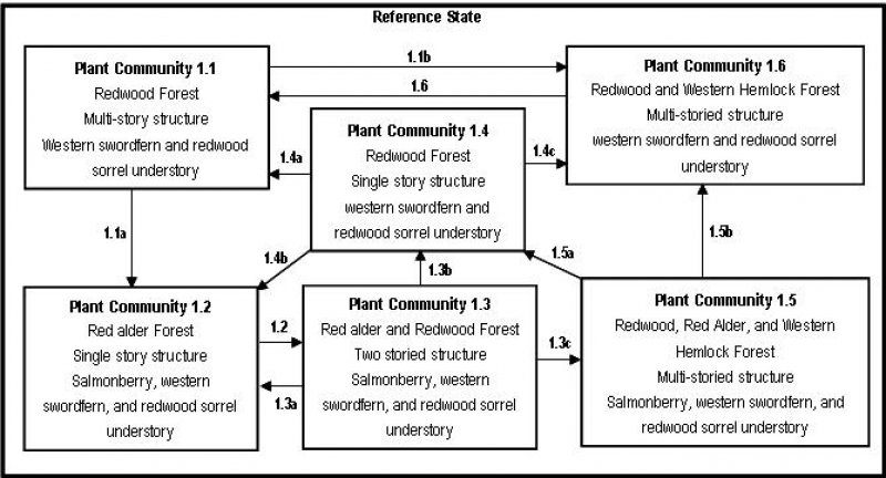
Figure 6. State and Transition Model
More interactive model formats are also available.
View Interactive Models
More interactive model formats are also available.
View Interactive Models
Click on state and transition labels to scroll to the respective text
State 1 submodel, plant communities
State 2 submodel, plant communities
State 3 submodel, plant communities
State 4 submodel, plant communities
State 5 submodel, plant communities
State 6 submodel, plant communities
State 1
Plant Community 1.2 - Red Alder Forest
Community 1.1
Plant Community 1.2 - Red Alder Forest

Figure 7. Alder-salmonberry
Red alder, salmonberry, and western swordfern may rapidly invade a site after a disturbance. Redwood-sorrel may also increase in cover. The estimated tree age for this plant community ranges from 0 to 5 years. Community Pathway 2.1: This community will transition to PC 1.3 as redwood sprouts slowly grow in height to become part of the canopy along with red alder.
State 2
Plant Community 1.1 - Redwood Forest
Community 2.1
Plant Community 1.1 - Redwood Forest
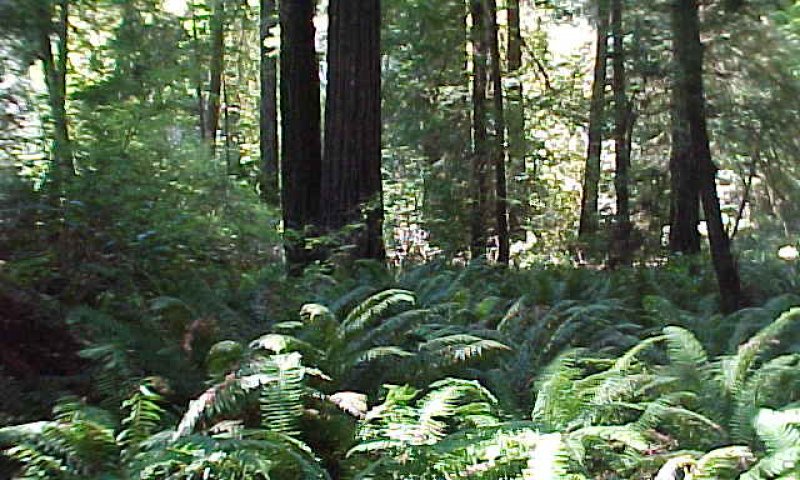
Figure 8. sese
The overstory of the interpretive plant community for this site is dominated by redwood (Sequoia sempervirens), with small groups or individuals of Sitka spruce (Picea sitchensis), western hemlock (Tsuga heterophyllia), and occasionally, grand fir (Abies grandis) occurring throughout this site. The tree age is this community is estimated to be 200 years or more. Red alder (Alnus rubra) may be present on some sites. Tanoak (Lithocarpus densiflorus) is usually not found, but may be a rare minor component.** Cover of shrubs is generally low and discontinuous, and may include small patches of salmonberry (Rubus spectabilis), California huckleberry (Vaccinium ovatum), red huckleberry (Vaccinium parvifolium) or salal (Gaultheria shallon). Cover of forbs is moderate to high, and includes western swordfern (Polystichum munitum), deer fern (Blechnum spicant) and redwood-sorrel (Oxalis oregano). The effects of winter winds create gaps in the canopy and contribute to the variations in species composition and stand structures in this plant community. Shade tolerant redwood, western hemlock or grand fir may fill in the smaller overstory gaps. Harvesting practices that mimic natural disturbances will tend to create similar species and compositional changes. Partial cutting and windthrow will allow regeneration of shade tolerant redwood, western hemlock, and grand fir within plant community 1.1. Community Pathway 1.1a: Block harvesting in moist redwood stands will commonly allow an infill of red alder, which may rapidly invade the site following a disturbance, and may transition PC 1.1 to PC 1.2. Community Pathway 1.1b: A lack of fire on some sites may cause western hemlock to become more common over time, transitioning this plant community to PC 1.6 **Note: This ecological site includes the riparian zone of some creeks within Redwood National and State Parks. Individual ecological sites must be described at a level equivalent to the individual components of the Order III soils map (NFM, 2000); because riparian zones were not delineated separately from alluvial terraces, they do not have individual ecosites. It is acknowledged that riparian vegetation composition and structure may vary significantly from the vegetation described in F004BX111CA.
Forest overstory. The overstory is dominated by redwood, with occasional stands of western hemlock, Sitka spruce, grand fir or Douglas-fir. Red alder may occur in patches in the sub-canopy.
Main overstory and average canopy cover
Redwood (Sequoia sempervirens)
60-100%
Sitka spruce (Picea sitchensis)
1-5%
Western hemlock (Tsuga heterophyllia) 5-10%
Grand fir (Abies grandis) 0-5%
Red alder (Alnus rubra) 1-5%
Forest understory. The understory is dominated by western swordfern and redwood-sorrel with ladyfern (Athyrium spp.) and deer fern as occasional associates. Salmonberry, California huckleberry, red huckleberry and salal may occur in small brush patches.
Shrub average cover
California huckleberry (Vaccinium ovatum) 5-10%
Salmonberry (Rubus spectabilis)
0-10%
Red huckleberry (Vaccinium parvifolium) 0-15%
Salal (Gaultheria shallon) 0-5
Forb average cover
Western swordfern (Polystichum munitum) 40-80%
Redwood-sorrel (Oxalis oregano)
5-15%
Ladyfern (Athyrium spp.) 0-5
Deer fern (Blechnum spicant) 0-10
Table 5. Ground cover
| Tree foliar cover | 75-100% |
|---|---|
| Shrub/vine/liana foliar cover | 10-40% |
| Grass/grasslike foliar cover | 0% |
| Forb foliar cover | 40-80% |
| Non-vascular plants | 0% |
| Biological crusts | 0% |
| Litter | 90-100% |
| Surface fragments >0.25" and <=3" | 0% |
| Surface fragments >3" | 0% |
| Bedrock | 0% |
| Water | 0% |
| Bare ground | 0% |
Table 6. Canopy structure (% cover)
| Height Above Ground (m) | Tree | Shrub/Vine | Grass/ Grasslike |
Forb |
|---|---|---|---|---|
| <0.15 | – | – | – | – |
| >0.15 <= 0.3 | – | – | – | – |
| >0.3 <= 0.6 | – | – | – | – |
| >0.6 <= 1.4 | – | – | – | 40-80% |
| >1.4 <= 4 | – | 10-40% | – | – |
| >4 <= 12 | – | – | – | – |
| >12 <= 24 | 0-5% | – | – | – |
| >24 <= 37 | 10-30% | – | – | – |
| >37 | 50-60% | – | – | – |
State 3
Plant Community 1.4 - Redwood Forest
Community 3.1
Plant Community 1.4 - Redwood Forest
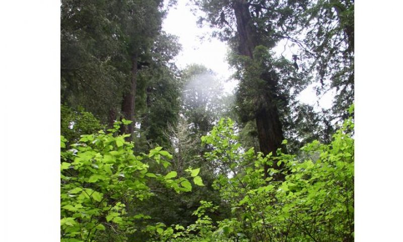
Figure 9. Salmonberry-Western swordfern
The redwood/western swordfern plant community could develop by using active management and removing the red alder. Redwood continues to grow and responds by filling in canopy gaps. The estimated tree age for this site ranges from 35 to 70 years. Remnants of salmonberry remain, but have less cover due to canopy closure. Western swordfern and redwood-sorrel remain the dominant forb cover. Community Pathway 1.4a: Over several hundred years, and with no significant disturbance, this plant community could be expected to return to the multi-storied redwood plant community seen in PC 1.1. Community Pathway 1.4b: If the redwood/red alder are block harvested, alder and salmonberry would likely infill, transitioning this plant community to PC 1.2. Community Pathway 1.4c: As other shade-tolerant conifers infill and grow, the population of western hemlock could potential increase at the site, and transition PC 1.4 to PC 1.6.
State 4
Plant Community 1.3 - Red alder-Redwood Forest
Community 4.1
Plant Community 1.3 - Red alder-Redwood Forest
The red alder/redwood plant community evolves after the initial red alder invasion. Redwood sprouts may be dominated by alder for a period of 25 years or more. The estimated tree age for this site ranges from 20 to 40 years. Salmonberry, western swordfern, and redwood-sorrel persist in the understory. Community Pathway 1.3a: If the red alder and redwoods are block harvested, the plant community would likely re-seed to red alder, transitioning this community back to PC 1.2. Remnants of salmonberry and western swordfern would return to the disturbed area rapidly via sprouting and wind-disseminated seed. Community Pathway 1.3b: The partial cutting of red alder would favor redwood by changing the species composition and transitioning the community to PC 1.4—a redwood-dominated forest. Remnants of the shrub community would inhabit the site, but may be diminished in number over time with increasing crown closure. Western swordfern and redwood-sorrel remain the dominant forb cover. Community Pathway 1.3c: With continued growth and lack of significant disturbances, redwood will eventually overtop the alder to dominate the site, and transition this community to PC 1.5. Remnants of the shrub community would remain but would be diminished in number with crown closure.
State 5
Plant Community 1.6 - Redwood-Western Hemlock
Community 5.1
Plant Community 1.6 - Redwood-Western Hemlock
Redwood dominates the overstory, with western hemlock as a significant associate. Shade-tolerant western hemlock and redwood regenerate are found in the understory. The estimated tree age for this site ranges from 75 to 200 years. If there is no significant disturbance, western hemlock and redwood will continue to regenerate in the understory and maintain PC 1.6. Community Pathway 1.6: Although infrequent, a light to moderate fire could kill the small and mature hemlock. With the seed source removed, the amount of western hemlock in the plant community would be reduced, transitioning the community back to PC 1.1.
State 6
Plant Community 1.5: Redwood-Red alder Forest
Community 6.1
Plant Community 1.5: Redwood-Red alder Forest
If given an extended period of time without disturbance, the conifers will surpass the height of the red alder, causing the alder to slowly die off. Western hemlock and redwood seedlings will continue to regenerate in the understory. The estimated tree age for this community ranges from 40 to 80 years. Community Pathway 1.5a: A redwood/western swordfern plant community could develop by either continued growth over time or by partial cutting, and transition this community back to PC 1.4. The estimated tree age for this community ranges from 40 to 80 years Community Pathway 1.5b: If there is a lack of significant disturbance, PC 1.5 will transition to PC 1.6, a mature multi-storied stand that includes redwood and western hemlock in the overstory.
Additional community tables
Interpretations
Animal community
The redwood forest supports an unknown, but large number of invertebrate species, and more that two hundred vertebrates. Few animal species are endemic and no known species are restricted to this site. The evidence suggests that most vertebrate species opportunistically adapted to the redwoods relatively recently, rather than having co-evolved with redwoods over a long period of geologic time (Noss and Cooperrider, 2000). The majority of this ecological site is free from both historic and recent logging activity.
A common invertebrate found on this site is the banana slug, which is a mature forest specialist. A number of other invertebrate species, including beetles, harvestman, spiders, millipedes, and freshwater mussels are also specialists throughout these sites.
This site is characterized by low reptile diversity with only northern alligator lizard, rubber boa, and California mountain king snake being found at the site. Streams, shaded seeps, and ample downed wood in various states of decay provide habitat for a variety of amphibians, including clouded salamander, California slender salamander, ensatina salamander, black salamander and tailed frog.
Although over a 100 bird species use redwood forests for breeding, feeding or nesting for at least one season, this redwood-dominated community provides a suitable habitat for only 41 species. The small groups of Sitka spruce, western hemlock and occasional grand fir increase the diversity of snags, downed logs and complex tree canopies. These structural components provide greater potential for nest sites and food resources (i.e. acorns and insects). The more common year round resident species are the Stellar’s jay, chestnut backed chickadee, brown creeper, winter wren, varied thrush, and hermit thrush. Summer breeders typically include Vaux’s swift, pacific slope flycatcher, hermit warbler, and Wilson’s warbler. Sensitive birds that nest in the site are the Marbled Murrelet and Northern spotted owl.
Watershed changes upstream resulted in the reduction of the historical runs of anadromous fish, which has subsequently decreased the diversity and abundance of predator species of mammals and birds. Such alterations in the food chain have contributed to the extirpation of the grizzly bear and the redistribution of species like the Bald Eagle, osprey, black bear, mountain lion, bobcat, and marten. These species may continue to use this habitat as transitory routes while moving around surrounding habitats.
What remains of the historic mammalian carnivores are the fisher and the raccoon. Other mammals common to this vegetation community are the fog shrew, Trowbridge shrew, shrew-mole, silver-haired bat and northern flying squirrel. Sensitive mammal species include fisher, marten, and mountain beaver.
Inclusions of riparian species (e.g. salmonberry, red alder, and big leaf maple (Acer macrophyllum)) along streams provide essential food and cover resources to the redwood forest wildlife that depend on riparian or aquatic habitats. Linear strips or patches of trees and shrubs adjacent to these streams provide nest sites, prey, berries, and water for breeding salamanders, snakes, birds, and bats.
Streams support both anadromous and resident fish populations. Anadromous salmonids known to occur include: coastal cutthroat trout, fall chinook salmon, chum salmon, and coho salmon, which uses lower gradient streams with medium gravels and a moderate pool to riffle ratio as spawning sites. Steelhead salmon is also common. It spawns in upper headwater reaches that may not be accessible to other anadromous salmonids.
Other fish species include river lamprey, pacific lamprey, threespine stickleback, and Klamath smallscale sucker. Tidewater gobies and longfin smelt are likely present in the estuaries, but they are a brackish or saltwater species and so are not expected to occur in freshwater streams on this site.
Hydrological functions
These soils have a moderate infiltration rate when thoroughly wet. They are very deep, poorly drained to well-drained and have a moderately fine texture. These soils have a moderate rate of water transmission.
Flooding or ponding is rare.
Hydrologic Groups
Bigtree--B
Mystery--B
Arlynda--B/D
Refer to the Soil Survey Manuscript for further information.
Recreational uses
Recreational use and development for campgrounds and trails may be limited by ponding and in very rare occasions, flooding.
Wood products
Redwood is a highly valued lumber because of its resistance to decay. Uses of redwood include house siding, paneling, trim and cabinetry, decks, hot tubs, fences, garden structures and retaining walls. Other uses include fascia, molding and industrial storage and processing tanks.
Sitka spruce is used in saw timber, wood pulp and plywood. It has a high weight to strength ratio, and is valued for use as masts for sail boats, oars, boats and racing sculls. It is also valued for use in making guitars and for piano sounding boards.
Other products
Salmonberry provides important food and cover for a variety of animals. Both deer and elk graze the leaves and twigs. Numerous bird and animal species consume the berries of the plant.
Supporting information
Inventory data references
Forestry data was collected at the following soil pits and notes:
Map unit Component Plot #
171 Arlynda no plots
171 Worswick no plots
174 Bigtree 04-007 04-013
04-012 04-058
174 Mystery 04-031 04-039
04-041
253 Littleriver 08-042
08-032
08-030
08-005 transect
Three transects were completed in map units 171 (1)and 174 (2).
Type locality
| Location 1: Humboldt County, CA | |
|---|---|
| Township/Range/Section | T10N R1E S9 |
| UTM zone | N |
| UTM northing | 4568578 |
| UTM easting | 409708 |
| General legal description | 2.5 miles south of intersection of westside access road and South Operations Center road on access road. |
Other references
Agee, James K. 1993. Fire Ecology of Northwest Forests. P 187-225.
Noss, Reed, F. editor. 2000. The Redwood Forest. 377 pages.
Silvics of North America. 1990. USDA Handbook 654
Viers, Stephen D. 1996. Ecology of the Coast Redwood. Conference on Coast Redwood Forest Ecology and Management. P 9-12.
Contributors
Judy Welles
Rangeland health reference sheet
Interpreting Indicators of Rangeland Health is a qualitative assessment protocol used to determine ecosystem condition based on benchmark characteristics described in the Reference Sheet. A suite of 17 (or more) indicators are typically considered in an assessment. The ecological site(s) representative of an assessment location must be known prior to applying the protocol and must be verified based on soils and climate. Current plant community cannot be used to identify the ecological site.
| Author(s)/participant(s) | |
|---|---|
| Contact for lead author | |
| Date | |
| Approved by | |
| Approval date | |
| Composition (Indicators 10 and 12) based on | Annual Production |
Indicators
-
Number and extent of rills:
-
Presence of water flow patterns:
-
Number and height of erosional pedestals or terracettes:
-
Bare ground from Ecological Site Description or other studies (rock, litter, lichen, moss, plant canopy are not bare ground):
-
Number of gullies and erosion associated with gullies:
-
Extent of wind scoured, blowouts and/or depositional areas:
-
Amount of litter movement (describe size and distance expected to travel):
-
Soil surface (top few mm) resistance to erosion (stability values are averages - most sites will show a range of values):
-
Soil surface structure and SOM content (include type of structure and A-horizon color and thickness):
-
Effect of community phase composition (relative proportion of different functional groups) and spatial distribution on infiltration and runoff:
-
Presence and thickness of compaction layer (usually none; describe soil profile features which may be mistaken for compaction on this site):
-
Functional/Structural Groups (list in order of descending dominance by above-ground annual-production or live foliar cover using symbols: >>, >, = to indicate much greater than, greater than, and equal to):
Dominant:
Sub-dominant:
Other:
Additional:
-
Amount of plant mortality and decadence (include which functional groups are expected to show mortality or decadence):
-
Average percent litter cover (%) and depth ( in):
-
Expected annual annual-production (this is TOTAL above-ground annual-production, not just forage annual-production):
-
Potential invasive (including noxious) species (native and non-native). List species which BOTH characterize degraded states and have the potential to become a dominant or co-dominant species on the ecological site if their future establishment and growth is not actively controlled by management interventions. Species that become dominant for only one to several years (e.g., short-term response to drought or wildfire) are not invasive plants. Note that unlike other indicators, we are describing what is NOT expected in the reference state for the ecological site:
-
Perennial plant reproductive capability:
Print Options
Sections
Font
Other
The Ecosystem Dynamics Interpretive Tool is an information system framework developed by the USDA-ARS Jornada Experimental Range, USDA Natural Resources Conservation Service, and New Mexico State University.
Click on box and path labels to scroll to the respective text.