
Natural Resources
Conservation Service
Ecological site R007XY153WA
Cool Loamy
Last updated: 3/11/2025
Accessed: 04/27/2025
General information
Provisional. A provisional ecological site description has undergone quality control and quality assurance review. It contains a working state and transition model and enough information to identify the ecological site.
MLRA notes
Major Land Resource Area (MLRA): 007X–Columbia Basin
This MLRA is in the Walla Walla Plateau section of the Columbia Plateaus province of the Intermontane Plateaus. The Columbia River flows through this MLRA, and the Snake and Yakima Rivers join the Columbia River within it. This MLRA is almost entirely underlain by Miocene basalt flows. Columbia River Basalt is covered in most areas with as much as 200 feet of eolian, lacustrine, and alluvial deposits. The dominant soil orders in this MLRA are Aridisols and Entisols. The soils in the area dominantly have a mesic temperature regime, an aridic moisture regime, and mixed mineralogy. They generally are moderately deep to very deep and well drained to excessively drained.
Classification relationships
Major Land Resource Area (MLRA): 007X – Columbia Basin
LRU – Common Resource Areas (CRA):
7.1 – Sandy Missoula Flood Deposits
7.2 – Silty Missoula Flood Deposits
7.4 – Dry Yakima Folds
7.5 – Yakima Valley – Pleistocene Lake Basins
Ecological site concept
Diagnostics:
Cool Loamy ecological site in MLRA 007X is much more limited in extent than the Cool Loamy ecological site in MLRA 008X.
This site is confined to north to north-east facing slopes on Saddle Mountain and Frenchman Hills at elevations of 1500 to 2000 feet. Cool Loamy ecological site is also found on the MLRA 007X portions of Rattlesnake Hills, Horse Heaven Hills and Beazley Hills, again on north to northeast slopes. Below 8 inches of precipitation, the Cool Loamy ecological site may be virtually nonexistent even on north aspects.
This is an upland site occurring on 20 inches and deeper loamy soils. These sites occur most commonly on silt loam, sandy loam and stony loam soils.
Cool Loamy ecological site in MLRA 007X has less threetip sage, less Idaho fescue, but more bluebunch wheatgrass than Cool Loamy in MLRA 008X. The shrub layer is generally a mixture of Wyoming big sagebrush, threetip sagebrush, horsebrush and rabbitbrush. The cover of Wyoming and basin big sagebrush will depend on how long it has been since the site burned. Bluebunch wheatgrass dominates the herbaceous layer with Idaho fescue a minor to co-dominant species.
Carey balsamroot is a common marker for MLRA 007X (less than 9 inches of precipitation).
Principle Vegetative Drivers:
The vegetative expression of this productive site is driven by two factors: (1) moderately deep to deep soil depth provides unrestricted rooting for most species, and (2) the microclimate which allows the shift in major plant species. With higher elevations or northerly facing slopes this ecological site has cooler temperatures year-round and longer lasting snowpack than other MLRA 007X ecological sites. This site provides crucial water to the vegetation at the hottest time of the growing season allowing the ecological site more resilience when impacted by disturbances. Also, being wetter and cooler, Cool Loamy ecological site supports a denser plant cover than the Loamy ecological site.
Associated sites
R007XY001WA |
Very Shallow |
---|---|
R007XY120WA |
Stony |
R007XY130WA |
Loamy |
Similar sites
R008XY153WA |
Cool Loamy threetip sagebrush Greater abundance of Idaho fescue and threetip sagebrush. |
---|---|
R008XY650WA |
Loamy North Aspect grassland Lacks threetip sagebrush. |
R009XC450WA |
North Aspect Bunchgrass 15-18 PZ Lacks threetip sagebrush. |
Table 1. Dominant plant species
Tree |
Not specified |
---|---|
Shrub |
(1) Artemisia tridentata ssp. wyomingensis |
Herbaceous |
(1) Pseudoroegneria spicata |
Physiographic features
The landscape is part of the Columbia basalt plateau. Cool Loamy sites are most commonly found on broad ridges, benches and plateaus, stream terraces, drier draw bottoms, north and northeast-facing hillslopes and in small basins
Physiographic Division: Intermontane Plateau
Physiographic Province: Columbia Plateau
Physiographic Sections: Walla Walla Plateau Section
Table 2. Representative physiographic features
Geomorphic position, hills |
(1) Nose Slope |
---|---|
Hillslope profile |
(1) Footslope |
Landforms |
(1)
Basin
(2) Hills (3) Terrace (4) Hillslope |
Flooding frequency | None |
Ponding frequency | None |
Elevation | 1,500 – 2,000 ft |
Slope | 2 – 30% |
Water table depth | 60 in |
Aspect | NW, N, NE |
Table 3. Representative physiographic features (actual ranges)
Flooding frequency | Not specified |
---|---|
Ponding frequency | Not specified |
Elevation | 220 – 3,500 ft |
Slope | 60% |
Water table depth | Not specified |
Climatic features
MLRA 007X is the lowest, driest and hottest portions of the entire Columbia River region and the sagebrush-bluebunch wheatgrass zone. Areas with threetip sagebrush and Idaho fescue when compared to Wyoming big sagebrush-bluebunch wheatgrass regions, are cooler from late-fall to early-spring (October through April), and has higher precipitation and precipitation-transpiration for five months (September, November, December, January and March) (Daubenmire).
The climate across MLRA 007X is characterized by moderately cold, wet winters, and hot, dry summers, with limited precipitation due to the rain shadow effect of the Cascades. The average annual precipitation for Cool Loamy ecological site is mostly between 6 and 10 inches. Seventy to seventy-five percent of the precipitation comes late October through March as a mixture of rain and snow. For Cool Loamy, March-May rains ensure good production and seed formation for Idaho fescue. June through early October is dry. Freezing temperatures generally occur from late-October through early-April. Temperature extremes are -10 degrees Fahrenheit in winter and 110 degrees Fahrenheit in summer. Winter fog is variable and often quite localized, as the fog settles on some areas but not others.
Table 4. Representative climatic features
Frost-free period (characteristic range) | 140-170 days |
---|---|
Freeze-free period (characteristic range) | |
Precipitation total (characteristic range) | 152-254 in |
Frost-free period (actual range) | 115-200 days |
Freeze-free period (actual range) | |
Precipitation total (actual range) |
Influencing water features
A plant’s ability to grow on a site and overall plant production is determined by soil-water-plant relationships
1. Whether rain and melting snow runs off-site or infiltrates into the soil
2. Whether soil condition remain aerobic or become saturated and become anaerobic
3. Water drainage and how quickly the soil reaches wilting point
Cool Loamy ecological site has cooler temperatures and longer lasting snow than other MLRA 008X ecological sites. Thus, this site supports a denser plant cover and provides water crucial to vegetation when it becomes hot.
Soil features
This ecological site components are dominantly Xeric taxonomic subgroup of Haplocambids great group of the Aridisols taxonomic orders. Soils are dominantly deep and very deep. Average available water capacity of about 7.0 inches (17.8 cm) in the 0 to 40 inches (0 to 100 cm) depth range.
Table 5. Representative soil features
Parent material |
(1)
Loess
|
---|---|
Surface texture |
(1) Silt loam (2) Very fine sandy loam |
Family particle size |
(1) Coarse-silty |
Drainage class | Well drained |
Depth to restrictive layer | 60 in |
Soil depth | 60 in |
Surface fragment cover <=3" | 2% |
Surface fragment cover >3" | Not specified |
Available water capacity (0-40in) |
7 in |
Electrical conductivity (Depth not specified) |
Not specified |
Sodium adsorption ratio (Depth not specified) |
Not specified |
Soil reaction (1:1 water) (0-10in) |
6.6 – 8.4 |
Subsurface fragment volume <=3" (Depth not specified) |
5% |
Subsurface fragment volume >3" (Depth not specified) |
1% |
Table 6. Representative soil features (actual values)
Drainage class | Not specified |
---|---|
Depth to restrictive layer | Not specified |
Soil depth | Not specified |
Surface fragment cover <=3" | 10% |
Surface fragment cover >3" | 5% |
Available water capacity (0-40in) |
2.7 – 8.3 in |
Electrical conductivity (Depth not specified) |
2 mmhos/cm |
Sodium adsorption ratio (Depth not specified) |
Not specified |
Soil reaction (1:1 water) (0-10in) |
Not specified |
Subsurface fragment volume <=3" (Depth not specified) |
20% |
Subsurface fragment volume >3" (Depth not specified) |
5% |
Ecological dynamics
Vegetation Dynamics:
Cool Loamy ecological site produces about 800 to 1200 pounds per acre of biomass annually.
On MLRA 008X Cool Loamy ecological sites, Idaho fescue and threetip sagebrush are dominant species. MLRA 007X is enough drier so that Cool Loamy ecological site is far more restricted on the landscape and Idaho fescue and threetip sagebrush are not as prominent in the plant community.
Compared to other upland ecological sites in MLRA 007X, Cool Loamy has more available soil moisture. This happens twofold: (1) there is more moisture (more spring rain, deeper snowpack, more fog), and (2) the precipitation is more effective (cooler temperatures, less runoff and less evaporation due to closer spacing of plants, and hence, more soil cover). Threetip sagebrush and Idaho fescue are especially linked to the additional soil moisture on this ecological site. The third dominant species in the Reference State, bluebunch wheatgrass, is not as linked to the additional soil moisture.
Threetip sagebrush is a short, shallow-rooted, evergreen shrub. Leaves are more deeply lobed than big sagebrush. Compared to big sagebrush, threetip sagebrush grows on sites that are moister or at higher elevations. Threetip sagebrush has a very slow growth rate, reaching a height of one foot after twenty years. In Washington threetip sagebrush generally sprouts following fire but it is not a big-time sprouter like rabbitbrush. It can take years for threetip sagebrush to get back to pre-burn conditions.
Idaho fescue is shorter and has a dense clump of shoots, while bluebunch wheatgrass is taller and is less dense. Both species are long-lived bunchgrasses. Bluebunch has an awned or awnless seed head arranged in a spike, while Idaho fescue has an awned seed head arranged in a panicle. The ratio of Idaho fescue to bluebunch wheatgrass plants on any site can vary due to aspect and elevation.
Both grasses provide a crucial and extensive network of roots to the upper portions (up to 48 inches deep in soils with no root-restrictive horizons) of the soil profile. These roots create a massive underground source to stabilize the soils, provide organic matter and nutrients inputs, and help maintain soil pore space for water infiltration and water retention in the soil profile. The extensive rooting system of mid-sized bunchgrasses leave very little soil niche space available for invasion by other species. This drought resistant root can compete with, and suppress, the spread of exotic weeds.
The stability and resiliency of the reference communities is directly linked to the health and vigor of Idaho fescue and bluebunch wheatgrass. More details about bunchgrass physiology included later. Research has found that the community remains resistant to medusahead invasion if the site maintains at least 0.8 plants per square foot of mid-sized bunchgrass (K. Davies 2008). These two bunchgrasses hold the system together. If we lose either or both bunchgrass the ecosystem begins to unravel.
The natural disturbance regime for grassland communities is periodic lightning-caused fires. The fire return intervals (FRI) listed in research for sagebrush steppe communities is quite variable. Ponderosa pine communities have the shortest FRI of about 10-20 years (Miller). The FRI increases as one moves to wetter forested sites or to dries shrub steppe communities. Given the uncertainties and opinions of reviewers, a mean of 75 years and a range of 50 to 100 years was chosen for Wyoming big sagebrush communities (Rapid Assessment Model). Threetip sagebrush-Idaho fescue areas should have a comparable fire return interval.
Some fires are spotty or do not burn hot enough to fully remove the sagebrush. Fires with light severity will remove less sagebrush and open smaller patches for grass and forb recovery, whereas the more severe fires will remove almost all the sagebrush and leave vast areas open to return to bunchgrass dominance. This is how the patchy distribution occurs. Rabbitbrush and horsebrush are sprouting shrubs and may also increase following fire.
The effect of fire on the main species is mixed for the Cool Loamy site. Threetip sagebrush in Central Washington sprouts from lateral roots or the root crown following fire and bluebunch wheatgrass is fire tolerant. Threetip sagebrush is also a vigorous, wind-dispersed seeder and in many cases, after fire, threetip sagebrush will both re-sprout and disperse new seed from the surviving plants. Both species recover quickly. But Idaho fescue is much more sensitive to fire. Under windy conditions, a fire can burn into the crown of Idaho fescue, leaving behind “black holes” or nothing but ash. When a site loses Idaho fescue, the holes will be filled by vigorous native species or exotic weeds. Threetip sagebrush and bluebunch wheatgrass keeps the site resistant to change, while Idaho fescue makes the site more at risk.
A severe fire puts stress on the entire community. The sagebrush layer is completely removed. Spots or patches with heavy sagebrush are sterilized by the fire and must be seeded to prevent invasive species (annual grasses, tumble mustard) from totally occupying the site. Bluebunch wheatgrass and basin wildrye will have weak vigor for a few years but generally survive. Idaho fescue plants are very much at risk with a severe burn coupled with wind. The result can be “black holes” or ash two to three inches into the crown. The death of Idaho fescue plants creates holes in the community, and the opportunity for exotic species to colonize. Needle and thread is one native species that can increase via new seedlings.
Idaho fescue and bluebunch wheatgrass exhibit rapid tillering when there is light severity fires and favorable soil moisture. But, the longer the site goes without fire and the more grazing pressure added, the more threetip sagebrush cover increases and the bunchgrasses decline.
Grazing is another common disturbance that occurs to this ecological site. Grazing pressure can be defined as heavy grazing intensity, or frequent grazing during reproductive growth, or season-long grazing (the same plants grazed more than once). As grazing pressure increases the plant community unravels in stages:
1. Idaho fescue declines while bluebunch wheatgrass and threetip sagebrush increase
2. Both Idaho fescue and bluebunch wheatgrass decline while threetip sagebrush and threadleaf sedge increase
3. With further decline invasive species colonize the site
4. The site can become a threetip sagebrush-threadleaf sedge community
Managing sagebrush steppe to improve the vigor and health of native bunchgrasses begins with an understanding of grass physiology. New growth each year begins from basal buds. Given the opportunity Idaho fescue readily produces new seedlings while bluebunch wheatgrass plants rely principally on tillering. During seed formation, the growing points of bluebunch wheatgrass become elevated and are vulnerable to damage or removal. Idaho fescue has weak stems and is much more sensitive to grazing than bluebunch wheatgrass.
If defoliated during the formation of seeds, bluebunch wheatgrass has limited capacity to tiller compared with other, more grazing resistant grasses (Caldwell et al., 1981). Repeated critical period grazing is especially damaging. Over several years each native bunchgrass pasture should be rested during the critical period two out of every three years (approximately April 15 – July 15). And each pasture should be rested the entire growing-season every third year (approximately March 1 – July 15).
In the spring each year it is important to monitor and maintain an adequate top growth: (1) so plants have enough energy to replace basal buds annually, (2) to optimize regrowth following spring grazing, (3) to protect the elevated growing points of bluebunch wheatgrass, and (4) to avoid excessing defoliation of Idaho fescue with its weak stems.
These grasses remain competitive if:
(1) Basal buds are replaced annually,
(2) Enough top-growth is maintained for growth and protection of growing points, and
(3) The timing of grazing and non-grazing is managed over a several-year period. Careful management of late spring grazing is especially critical
For more grazing management information refer to Range Technical Notes found in Section I Reference Lists of NRCS Field Office Technical Guide for Washington State.
In Washington, threetip sagebrush – Idaho fescue/bluebunch wheatgrass communities provide habitat for a variety of upland wildlife species.
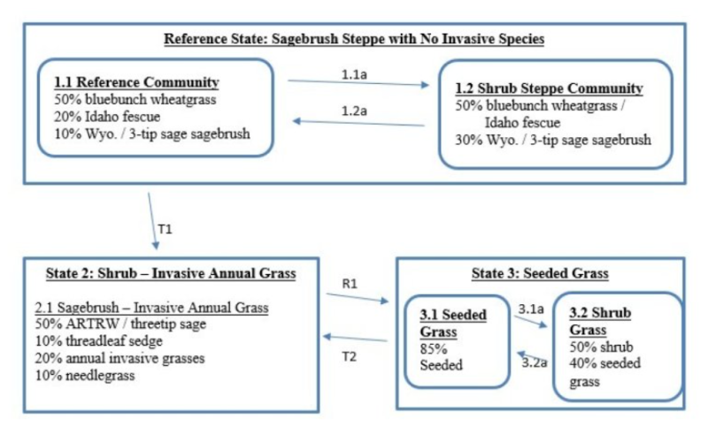
State and transition model

More interactive model formats are also available.
View Interactive Models
More interactive model formats are also available.
View Interactive Models
Click on state and transition labels to scroll to the respective text
Ecosystem states
State 2 submodel, plant communities
State 3 submodel, plant communities
State 1
Reference
Communities 1.1 and 1.2 are stable with a high cover of bluebunch wheatgrass/Idaho fescue and low to moderate cover of Wyoming big or threetip sagebrush. Both communities have a minor amount of threadleaf sedge which is native, but also rhizomatous. But when the dominant bunchgrasses exhibit low vigor and decline, sagebrush and threadleaf sedge increase and Japanese brome colonizes the disturbed sites. Dominate Reference State Species: Bluebunch wheatgrass, Idaho fescue, sagebrush (Wyoming big/threetip) At-risk Communities: • All communities in the reference state are at risk of invasive species. The seed source for Japanese brome or other invasive annual seed blows onto most sites annually. • Any community becomes at-risk of moving to State 3 when bluebunch wheatgrass and Idaho fescue have low vigor, the cover of sagebrush is expanding, and Japanese brome has colonized the site. • Any community is at risk when fire kills the Idaho fescue plants. The holes could quickly be filled by Japanese brome, cheatgrass or threadleaf sedge. The site should be inter-seeded that fall or early the following spring
Community 1.1
Bluebunch Wheatgrass, Idaho Fescue, Wyoming Big Sagebrush, and Threetip Sagebrush
Figure 1. Annual production by plant type (representative values) or group (midpoint values)
Community 1.2
Wyoming Big Sagebrush, Threetip Sagebrush, Idaho Fescue, and Bluebunch Wheatgrass
Pathway 1.1A
Community 1.1 to 1.2
Result: shift from reference community to shrub steppe community. Moderate reduction in bunchgrasses and a moderate increase in threetip sagebrush Primary Trigger: grazing pressure (heavy grazing intensity, season long grazing or frequent late spring grazing) coupled with a period of no fire, give shrubs the competitive edge. Ecological process: Consistent defoliation pressure to Idaho fescue and bluebunch wheatgrass results in poor vigor and shrinking crowns. Sagebrush sets new seedlings and expands. Indicators: decrease in Idaho fescue and bluebunch wheatgrass cover coupled with new sagebrush seedlings.
Pathway 1.2A
Community 1.2 to 1.1
Result: shift from shrub steppe community to reference community. Sagebrush declines while bunchgrasses increase Primary Trigger: Moderate severity fire kills Wyoming big sagebrush and sets threetip sagebrush back while perennial bunchgrasses expand given the opportunity and good vigor both pre- and post-fire. Also, the fire would need to not burn into the root crown of Idaho fescue. Ecological process: Idaho fescue and other bunchgrasses have good vigor post-fire and expand via tillering and new seedlings.
State 2
Shrub and Invasive Annual Grass
State 2 represents a shrub-invasive annual grass community. Many native functional, structural groups have been altered or are missing. Annual grasses such as Japanese brome are present but secondary to the shrub and sedge components.
Community 2.1
Wyoming Big Sagebrush, Threetip Sagebrush, Threadleaf Sedge, and Invasive Annual Grasses
50% Wyoming Big Sagebrush / Threetip Sagebrush 10% Threadleaf Sedge 20% Invasive Annual Grasses 10% Needlegrass
State 3
Seeded
State 3 represents sites that have been seeded. The site was no longer productive for intended uses. So, a commitment was made to kill existing stand and seed more desirable species.
Community 3.1
Seeded Grasses
85% seeded grasses
Community 3.2
Shrubs and Seeded Grasses
50% shrubs, 40% seeded grasses
Pathway 3.1A
Community 3.1 to 3.2
Seeded grass community shifts to a shrub-grass community. Primary Trigger: heavy grazing pressure to the desirable grasses put them in decline while the shrubs increase. Ecological Process: consistent defoliation pressure to desirable seeded species results in poor vigor, shrinking crowns and mortality. The shrub layer expands and becomes co-dominant via new seedlings.
Pathway 3.2A
Community 3.2 to 3.1
Shrub-grass community shifts back to seeded grass community Primary Trigger: If the stand still has a good stand of bunchgrasses, shrubs are controlled by chemical treatment. Bunchgrasses will need good plant vigor pre- and post-treatment. Fire conditions and post-fire grazing management allows Idaho and bluebunch wheatgrass to thrive and expand. Ecological Process: fire kills the Wyoming sagebrush and sets threetip sagebrush back which releases resources. Bunchgrasses thrive and expand via tillering or new seedlings.
Transition T1A
State 1 to 2
The Reference State has only a minor amount of threadleaf sedge and no invasive species. In State 2 sagebrush and invasive annual grasses become dominant. Primary Trigger: Heavy grazing pressure (heavy grazing intensity, season-long grazing or frequent late-spring grazing) on bluebunch wheatgrass and Idaho fescue. Also, soil disturbances by rodents and badgers allow annual grasses to colonize. Ecological process. Consistent defoliation pressure (heavy grazing, season long grazing or frequent late spring grazing) The cover of sagebrush increases, and invasive annual grasses have colonized the site and become prominent. Indicators: increasing gaps between dominant bunchgrasses (bluebunch wheatgrass and Idaho fescue). Expanding cover of sagebrush and invasive species.
Restoration pathway R2A
State 2 to 3
This restoration transition does not occur without significant time and inputs to control weeds, prepare a seedbed, seed desirable species, and post-seeding weed control and management. This requires a commitment of two years or more to kill threadleaf sedge and for weed control. Care must be taken to maintain soil structure so that the seedbed has many safe sites for the seed. Seed placement must be managed to achieve seed-soil contact at very shallow depth (about 1/8 inch is desired). Proper grazing management is essential to maintain the stand post-seeding. Secar Snake River wheatgrass, thickspike wheatgrass, Sherman big bluegrass, Sandberg bluegrass, and crested or intermediate wheatgrass are typical species seeded on Cool Loamy ecological site. The actual transition occurs when the seeded species have successfully established and are outcompeting the threadleaf sedge, shrubs and annual species for cover and dominance of resources.
Transition T3A
State 3 to 2
This transition occurs when the cover of seeded grasses drops to less than 10% and invasive annual grasses have assumed a dominant position in the community. Primary trigger: heavy grazing pressure (heavy grazing intensity, season long grazing or frequent late spring grazing) reduces the vigor of the desirable seeded species. Ecological process: consistent defoliation pressure to desirable seeded grasses results in poor vigor, shrinking crowns and mortality. The competitive edge has shifted from seeded grasses to shrubs and annual grasses. Indicators: Declining cover for the seeded species. Increasing canopy gaps between desirable seeded species. Increasing cover of sagebrush and invasive species.
Additional community tables
Table 7. Community 1.1 plant community composition
Group | Common name | Symbol | Scientific name | Annual production (lb/acre) | Foliar cover (%) | |
---|---|---|---|---|---|---|
Shrub/Vine
|
||||||
1 | 85 | |||||
Wyoming big sagebrush | ARTRW8 | Artemisia tridentata ssp. wyomingensis | – | – | ||
2 | 45 | |||||
threetip sagebrush | ARTR4 | Artemisia tripartita | – | – | ||
rabbitbrush | CHRYS9 | Chrysothamnus | – | – | ||
spineless horsebrush | TECA2 | Tetradymia canescens | – | – | ||
buckwheat | ERIOG | Eriogonum | – | – | ||
Grass/Grasslike
|
||||||
3 | 650 | |||||
bluebunch wheatgrass | PSSP6 | Pseudoroegneria spicata | – | – | ||
Idaho fescue | FEID | Festuca idahoensis | – | – | ||
4 | 45 | |||||
squirreltail | ELEL5 | Elymus elymoides | – | – | ||
Thurber's needlegrass | ACTH7 | Achnatherum thurberianum | – | – | ||
needle and thread | HECO26 | Hesperostipa comata | – | – | ||
5 | 45 | |||||
Sandberg bluegrass | POSE | Poa secunda | – | – | ||
6 | 0 | |||||
threadleaf sedge | CAFI | Carex filifolia | – | – | ||
Forb
|
||||||
7 | 45 | |||||
Carey's balsamroot | BACA3 | Balsamorhiza careyana | – | – | ||
lupine | LUPIN | Lupinus | – | – | ||
hawksbeard | CREPI | Crepis | – | – | ||
longleaf phlox | PHLO2 | Phlox longifolia | – | – | ||
spiny phlox | PHHO | Phlox hoodii | – | – | ||
desertparsley | LOMAT | Lomatium | – | – | ||
milkvetch | ASTRA | Astragalus | – | – | ||
low pussytoes | ANDI2 | Antennaria dimorpha | – | – | ||
woolly plantain | PLPA2 | Plantago patagonica | – | – | ||
common yarrow | ACMI2 | Achillea millefolium | – | – | ||
silverpuffs | MICRO6 | Microseris | – | – | ||
onion | ALLIU | Allium | – | – | ||
mariposa lily | CALOC | Calochortus | – | – | ||
fleabane | ERIGE2 | Erigeron | – | – | ||
granite prickly phlox | LIPU11 | Linanthus pungens | – | – | ||
buckwheat | ERIOG | Eriogonum | – | – | ||
Indian paintbrush | CASTI2 | Castilleja | – | – | ||
trumpet | COLLO | Collomia | – | – | ||
western stoneseed | LIRU4 | Lithospermum ruderale | – | – |
Interpretations
Supporting information
Inventory data references
Data to populate Reference Community came from several sources: (1) NRCS ecological sites from 2004, (2) Soil Conservation Service range sites from 1980s and 1990s, (3) Daubenmire’s habitat types, and (4) ecological systems from Natural Heritage Program
Other references
Boling M., Frazier B., Busacca, A., General Soil Map of Washington, Washington State University, 1998
Daubenmire, R., Steppe Vegetation of Washington, EB1446, March 1968
Davies, Kirk, Medusahead Dispersal and Establishment in Sagebrush Steppe Plant Communities, Rangeland Ecology & Management, 2008
Environmental Protection Agency, map of Level III and IV Ecoregions of Washington, June 2010
Miller, Baisan, Rose and Pacioretty, “Pre and Post Settlement Fire regimes in mountain Sagebrush communities: The Northern Intermountain Region
Natural Resources Conservation Service, map of Common Resource Areas of Washington, 2003
Rapid Assessment Reference Condition Model for Wyoming sagebrush, LANDFIRE project, 2008
Rocchio, Joseph & Crawford, Rex C., Ecological Systems of Washington State. A Guide to Identification. Washington State Department of Natural Resources, October 2015. Pages 156-161 Inter-Mountain Basin Big Sagebrush
Rouse, Gerald, MLRA 8 Ecological Sites as referenced from Natural Resources Conservation Service-Washington FOTG, 2004
Soil Conservation Service, Range Sites for MLRA 8 from 1980s and 1990s
Tart, D., Kelley, P., and Schlafly, P., Rangeland Vegetation of the Yakima Indian reservation, August 1987, YIN Soil and Vegetation Survey
Approval
Kirt Walstad, 3/11/2025
Rangeland health reference sheet
Interpreting Indicators of Rangeland Health is a qualitative assessment protocol used to determine ecosystem condition based on benchmark characteristics described in the Reference Sheet. A suite of 17 (or more) indicators are typically considered in an assessment. The ecological site(s) representative of an assessment location must be known prior to applying the protocol and must be verified based on soils and climate. Current plant community cannot be used to identify the ecological site.
Author(s)/participant(s) | |
---|---|
Contact for lead author | |
Date | 01/24/2025 |
Approved by | Kirt Walstad |
Approval date | |
Composition (Indicators 10 and 12) based on | Annual Production |
Indicators
-
Number and extent of rills:
-
Presence of water flow patterns:
-
Number and height of erosional pedestals or terracettes:
-
Bare ground from Ecological Site Description or other studies (rock, litter, lichen, moss, plant canopy are not bare ground):
-
Number of gullies and erosion associated with gullies:
-
Extent of wind scoured, blowouts and/or depositional areas:
-
Amount of litter movement (describe size and distance expected to travel):
-
Soil surface (top few mm) resistance to erosion (stability values are averages - most sites will show a range of values):
-
Soil surface structure and SOM content (include type of structure and A-horizon color and thickness):
-
Effect of community phase composition (relative proportion of different functional groups) and spatial distribution on infiltration and runoff:
-
Presence and thickness of compaction layer (usually none; describe soil profile features which may be mistaken for compaction on this site):
-
Functional/Structural Groups (list in order of descending dominance by above-ground annual-production or live foliar cover using symbols: >>, >, = to indicate much greater than, greater than, and equal to):
Dominant:
Sub-dominant:
Other:
Additional:
-
Amount of plant mortality and decadence (include which functional groups are expected to show mortality or decadence):
-
Average percent litter cover (%) and depth ( in):
-
Expected annual annual-production (this is TOTAL above-ground annual-production, not just forage annual-production):
-
Potential invasive (including noxious) species (native and non-native). List species which BOTH characterize degraded states and have the potential to become a dominant or co-dominant species on the ecological site if their future establishment and growth is not actively controlled by management interventions. Species that become dominant for only one to several years (e.g., short-term response to drought or wildfire) are not invasive plants. Note that unlike other indicators, we are describing what is NOT expected in the reference state for the ecological site:
-
Perennial plant reproductive capability:
Print Options
Sections
Font
Other
The Ecosystem Dynamics Interpretive Tool is an information system framework developed by the USDA-ARS Jornada Experimental Range, USDA Natural Resources Conservation Service, and New Mexico State University.
Click on box and path labels to scroll to the respective text.