Natural Resources
Conservation Service
Ecological site R007XY720WA
Riparian Complex
Last updated: 2/06/2025
Accessed: 04/12/2026
General information
Provisional. A provisional ecological site description has undergone quality control and quality assurance review. It contains a working state and transition model and enough information to identify the ecological site.
MLRA notes
Major Land Resource Area (MLRA): 007X–Columbia Basin
This MLRA is in the Walla Walla Plateau section of the Columbia Plateaus province of the Intermontane Plateaus. The Columbia River flows through this MLRA, and the Snake and Yakima Rivers join the Columbia River within it. This MLRA is almost entirely underlain by Miocene basalt flows. Columbia River Basalt is covered in most areas with as much as 200 feet of eolian, lacustrine, and alluvial deposits. The dominant soil orders in this MLRA are Aridisols and Entisols. The soils in the area dominantly have a mesic temperature regime, an aridic moisture regime, and mixed mineralogy. They generally are moderately deep to very deep and well drained to excessively drained.
Classification relationships
Major Land Resource Area (MLRA): 007X – Columbia Basin
LRU – Common Resource Areas (CRA):
7.1 – Sandy Missoula Flood Deposits
7.2 – Silty Missoula Flood Deposits
7.3 – Dry Loess Islands
7.4 – Dry Yakima Folds
7.5 – Yakima Valley – Pleistocene Lake Basins
Ecological site concept
NRCS Washington has never had an ecological site for riparian areas in MLRA 007X, 008X and 009X, so this is a starting point. The Riparian complex ecological site is extremely general and will continue to be a work in progress for some time. There are precipitation ranges for these sites, but precipitation is not the main driver of the site development.
Diagnostics:
A bottomland tree-shrub ecological site, Riparian Complex sits in the floodplain position of the landscape as a narrow, linear corridor along perennial streams or spring fed reaches on intermittent streams. It also occurs as a small patch near ponds, lakes and springs, or on bottoms, depressions and basins.
This site receives seasonal flooding or discharging groundwater from sites uphill. Riparian complex ecological site is part of the lotic or flowing water ecosystem. Soils are often cobbly and well drained, so they remain saturated for only a short period. The soils are not hydric, nor is this ecological site a wetland.
In the sagebrush steppe and grassland steppe regions, bunchgrasses, shrubs and forbs are common, but trees are rare. The Riparian Complex ecological site stands out because of the presence of trees and tall shrubs.
Principle Vegetative Drivers:
The vegetative expression of the Riparian complex ecological site is driven by three situations. First, this site receives off-site water - overbank flooding and surface runoff for some sites or, discharging groundwater for sites influenced by springs or seeps. Second, the soils are deep and have unrestricted rooting. Third, the soils are well drained and supports trees and shrubs instead of aquatic plants.
Table 1. Dominant plant species
| Tree |
(1) Populus balsamifera ssp. trichocarpa |
|---|---|
| Shrub |
(1) Salix |
| Herbaceous |
Not specified |
Physiographic features
The landscape is part of the Columbia basalt plateau. Riparian complex ecological sites occur as a narrow, linear corridor on floodplains and terraces along perennial streams or spring-fed reaches of intermittent streams at elevations of 300 to 2,000 feet. There are also Riparian Complex ecological site patches on draws, basins, depressions, and near ponds, lakes or springs. Slopes of 0 to 5 percent are most common. In the upland setting ecological sites are often expansive, and thus, can be delineated and separated on aerial photos. But in the landscape position of bottoms, basins and depressions this is rarely the case as small changes in soil chemistry, the water table and elevation or aspect results in significant changes in plant community composition. In short distances there are often big swings of available water holding capacity, and soils can go from hydric to non-hydric, or from saline-sodic to not. So, in bottoms, riparian areas and depressions, ecological sites and community phases occur as small spots, strips and patches, or as narrow rings around vernal ponds. Generally, in a matter of steps one can walk across several ecological sites. On any given site location, two or more of these ecological sites occur as a patchwork – Loamy Bottom, Alkali Terrace, Sodic Flat, Wet Meadow, Herbaceous Wetland and Riparian Complex. These ecological sites may need to be mapped as a complex when doing resource inventory.
Physiographic Division: Intermontane Plateau
Physiographic Province: Columbia Plateau
Physiographic Sections: Walla Walla Plateau Section
Table 2. Representative physiographic features
| Slope shape up-down |
(1) Concave |
|---|---|
| Slope shape across |
(1) Concave |
| Landforms |
(1)
Valley
(2) Hills (3) Plateau (4) Flood plain (5) Drainageway |
| Flooding frequency | Rare to frequent |
| Ponding frequency | None |
| Elevation | 300 – 2,000 ft |
| Slope | 3% |
| Water table depth | 20 – 60 in |
| Aspect | W, NW, N, NE, E, SE, S, SW |
Table 3. Representative physiographic features (actual ranges)
| Flooding frequency | Not specified |
|---|---|
| Ponding frequency | Not specified |
| Elevation | Not specified |
| Slope | 5% |
| Water table depth | Not specified |
Climatic features
The climate is characterized by moderately cold, wet winters, and hot, dry summers, with limited precipitation due to the rain shadow effect of the Cascades. Taxonomic soil climate is an aridic or aquic moisture regime with a mesic temperature regime. This MLRA is the warmest and driest MLRA within the Columbia Plateau geographic area.
Table 4. Representative climatic features
| Frost-free period (characteristic range) | 140-170 days |
|---|---|
| Freeze-free period (characteristic range) | |
| Precipitation total (characteristic range) | 152-254 in |
| Frost-free period (actual range) | 130-200 days |
| Freeze-free period (actual range) | |
| Precipitation total (actual range) |
Influencing water features
A plant’s ability to grow on a site and overall plant production is determined by soil-water-plant relationships:
1. Whether rain and melting snow run off-site or infiltrate into the soil
2. Whether soil condition remain aerobic or become saturated and anaerobic
3. How quickly the soil reaches the wilting point
Most sites experience overbank flooding and surface runoff. But for sites influenced by springs or seeps, discharging groundwater is the important driver. The soils are deep, well drained, and often cobbly, and thus, remain saturated for only a short period in late winter to early spring. With adequate cover of live plants and litter, there are no water infiltrating restrictions on Riparian Complex.
Soil features
This ecological site’s soil components are dominantly Xeric, Fluvaquentic and Torrifluventic taxonomic subgroups of Torrifluvents, Haploxerolls and Endoaquolls great groups of the Mollisol and Entisol taxonomic order, but also includes the Aquandic subgroups of Aridisols taxonomic order. Soils are dominantly very deep. Average available water capacity of about 4 inches (15.3 cm) in the 0 to 40 inches (0 to 100 cm) depth range.
The associated soils are Weirman, Xeric Torriorthents and similar soils.
Table 5. Representative soil features
| Parent material |
(1)
Alluvium
|
|---|---|
| Surface texture |
(1) Silt loam (2) Gravelly sandy loam |
| Drainage class | Somewhat poorly drained to somewhat excessively drained |
| Depth to restrictive layer | 60 in |
| Soil depth | 60 in |
| Surface fragment cover <=3" | 10% |
| Surface fragment cover >3" | 5% |
| Available water capacity (0-40in) |
4 in |
| Calcium carbonate equivalent (Depth not specified) |
30% |
| Electrical conductivity (Depth not specified) |
20 mmhos/cm |
| Sodium adsorption ratio (Depth not specified) |
30 |
| Soil reaction (1:1 water) (0-10in) |
6.1 – 9.5 |
| Subsurface fragment volume <=3" (Depth not specified) |
10% |
| Subsurface fragment volume >3" (Depth not specified) |
10% |
Table 6. Representative soil features (actual values)
| Drainage class | Not specified |
|---|---|
| Depth to restrictive layer | Not specified |
| Soil depth | Not specified |
| Surface fragment cover <=3" | 25% |
| Surface fragment cover >3" | 30% |
| Available water capacity (0-40in) |
1 – 9.1 in |
| Calcium carbonate equivalent (Depth not specified) |
Not specified |
| Electrical conductivity (Depth not specified) |
Not specified |
| Sodium adsorption ratio (Depth not specified) |
Not specified |
| Soil reaction (1:1 water) (0-10in) |
Not specified |
| Subsurface fragment volume <=3" (Depth not specified) |
40% |
| Subsurface fragment volume >3" (Depth not specified) |
30% |
Ecological dynamics
Vegetation Dynamics:
Riparian complex ecological site produces about 2000 pounds per acre of biomass annually up to 4.5 feet Understory production is dependent on canopy cover.
Low canopy = high production. High canopy = low production
Ecological Dynamics Overview:
Riparian areas are heavily influenced by fluvial processes. This provisional ecological site concept is composed of a variety of different riverine systems and will require more detailed field investigations to refine the site concepts and likely develop several new sites that are correlated to similar geologic structure and processes, hydrologic regimes, and vegetation characteristics. This ecological site concept captures variety of typical riparian vegetation expressions. The band of riparian vegetation may be broader if part of a larger river system, or narrower if part of a small stream system.
Basic Understanding of Riparian Systems – Abiotic Factors/Primary Disturbance
(from Kendra Moseley, NRCS):
Riparian forests are a complex interaction of many various physical and biologic factors, including function of valley morphology, physical processes, vegetative legacies, and life history strategies. The watershed geomorphology and physical processes form the basis for understanding the spatial extent of the riparian forests, which includes the valley shape, hillslope processes, fluvial processes, soil processes, and hydrologic processes. Soil development within alluvial environments is highly variable. Frequent erosional and depositional disturbances from flooding create a complex mosaic of soil conditions in the active floodplain that fundamentally influences vegetation colonization and establishment. Well-drained soil or recently deposited mineral alluvium may be found adjacent to very poorly drained organic soils in abandoned high-flow channels. This variability in soil conditions is a major factor in maintaining the high plant diversity typical of riparian ecological sites.
The disturbances that drive this ecological site concept are dependent on the type, frequency, predictability, extent, magnitude, and timing of the disturbance. The fluvial processes that are dominant in this riparian ecological site concept include stream power, basal shear stress, channel migration, and sediment deposition. The characteristic vegetation pattern of these low-gradient valleys is maintained by fluvial disturbances and geomorphology. The amount of force exerted on the channel bed and vegetation growing in the active channel and floodplain during a flood is a product of fluid density, gravitational acceleration, flow depth, and water surface slope.
The diagram below outlines the complexity of abiotic factors that play a role in these mostly alluvial river systems and the riparian vegetation expression and dynamics that are associated with them.
Basic understanding of Channel Evolution
(From Stream Visual Assessment, Version 2, December 2009:
Some understanding of stream geomorphology helps our understanding of the ecological dynamics of these fluvial systems.
Channel slope is directly related to topography, geology, sinuosity, bed material and watershed size. Straight stream channels are indicative of strong geologic structure (bedrock) or human control. Braided streams have multiple interwoven channels. Meandering channels are highly variable and sinuous.
The shape of a stream channel changes constantly, im¬perceptibly, or dramatically, depending on the condi¬tion of the stream corridor (channel, riparian area, and flood plain) and how it transports water and materials. Channel condition is a description of the geomorphic stage of the channel as it adjusts its shape relative to its flood plain. Channel adjustments resulting in a dra¬matic drop in streambed elevation (incision or degra¬dation) or excessive deposition of bedload that raises the bed elevation (aggradation) affect the degree of bank shear and often decrease stream channel stabil¬ity. Such channel adjustments can have substantial effects on the condition of streams, adjacent riparian areas, associated habitats, and their biota. For ex¬ample, the greater the incision in a channel, the more it is separated from its flood plain, both physically and ecologically. Conversely, the greater the aggradation, the wider and shallower a stream becomes, which can affect riparian vegetation, surface water temperatures, and stream and riparian habitat features.
Conceptual models of how a channel evolves or ad¬justs over time illustrate the sequence of geomorphic changes in a stream that result from disturbances in the watershed. Such sequences are useful for evalu¬ating trends in channel condition. The stages of the Schumm Channel Evolution Model (CEM), as shown in figure 3, provide a visual orientation of the pattern of streambed adjustment in an incising stream, its gradual detachment from the existing flood plain, and eventual formation of a new flood plain at a lower elevation. A similar model by Simon (1989) is also de¬scribed in the Stream Corridor Restoration Handbook (FISRWG 1998) available in most NRCS field offices.
Evolution of a Stream:
Stage I channels are generally stable and have fre¬quent interaction with their flood plains. The relative stability of the streambed and banks is because the stream and its flood plain are connected, and flooding occurs at regular intervals (Q2). Consequently, the stream’s banks and flood plain are well vegetated. The Stage I channel undergoes initial incision. In Stage II the bed degrades, and banks are stable. During Stage III the bed aggrades, banks are unstable, and the channel goes through the widening phase. Stage IV is the stabilizing phase where the bed continues aggrading, but the banks are stable. Then in Stage V the slow aggrading continues but now banks are stable, and the new floodplain is forming. The new floodplain is lower and narrower than the original floodplain.
Especially on larger streams, variations on riparian areas (clumps and strips) are common. Variations are controlled by valley width, sediment type and overbank flooding. Clumps and strips of dominant trees species found on riparian areas can include – black cottonwood, aspen, water birch, white alder and several different willow species. Smaller streams are less diverse than larger streams. Overbank flooding and gravel bars are required for tree regeneration for many riparian trees, especially for black cottonwood.
Ecological Dynamics (from Frank G.):
The riparian woodland sites in MLRAs 007X, 008X, and 009X will vary based on their locations in various watersheds of the region and available moisture and soil texture/depth of the sites. Sites that have sufficient soil texture and depth will have a tall tree component like black cottonwood and/or quaking aspen. Sites that are drier will have a short tree or shrub component like hawthorn, chokecherry or mockorange. Also, the size of the watershed that drains an area and adjacent land cover will influence the amount of water entering the riparian area.
Riparian woodlands are essential to keep streambanks stable, stream temperatures cool, and buffer potential impacts from adjacent land uses. Riparian woodlands provide valuable wildlife habitat for a variety of species. Native riparian woodlands can recover from low intensity fires through tree/shrub root sprouting or seed regeneration. Serious impacts can occur when these areas are continually overgrazed or removed/reduced for another land use.
Fire Ecology:
Forested riparian areas (Riparian Woodlands) are unique ecosystems which provide critical habitat for many species of terrestrial and aquatic species. Forested riparian zones occur adjacent to two broadly associated upland ecosystems. In dryer areas, the adjacent upland type was historically steppe or shrub/steppe, and in areas of increasing rainfall, the adjacent upland was dominated by coniferous forests. In large scale watersheds with appreciable climatic gradients, the riparian zone passes through and connects these two upland types.
Riparian areas are subject to a number of ecologic disturbance influences, including wildfire. Wildfire frequency (the historic intervals between various types of fires), severity (the impacts of any given fire episode), and the type (surface, crown, mixed) of fire occurring within these riparian zones was highly variable.
Riparian ecosystems that were adjacent to prairie vegetation experienced a relatively frequent surface fire return interval. Fire typically entered into the riparian zone from fires originating in the upland grass dominated vegetation. Black cottonwood hardwoods were likely the only true tree species, growing along with adapted understory shrubs and grass species.
Riparian areas adjacent to upland conifer forests have a wider expression of tree and understory species. These areas would typically burn in the same upland fire event, and experience the impacts similar to the surrounding upland forests, especially when upland the fire episode was more severe.
Fire impacts, and natural adaptation to common riparian tree, shrub and grass species:
Black cottonwood is easily killed by fire, but coppice sprouting is common. Fire can improve seedling establishment by increasing light penetration and exposing mineral soil to allow seedling establishment if moisture is available. It can endure on site as well as invade following fire.
Ponderosa pine is resistant to fire by the development of thick, platy bark which begins to form at a young age. It naturally prunes the lower bole, decreasing the likelihood of crown ignition, and the open nature of the needles resist damage when upper crow fires do occur. It is also long lived, and will regenerate on open, sunny areas which are often produced by surface fire.
Quaking aspen regenerates by clonal regeneration following light to moderately severe fire.
Various species of willows, sedges and grasses regrow following all but severe fires, from root crowns or underground rhizomes.
Lupine, manzanita and Ceanothus produce hard shelled seeds that require fire scarification to germinate and become established.
Many other plant species produce light weight seeds which easily travel on wind currents to disturbed areas.
In the past century, in what is referred to as the period of post-European settlement, riparian forests have undergone many human caused changes. Logging up to the edge of the stream, conversion to agriculture, fire exclusion, forest fragmentation and especially unregulated livestock grazing have all contributed to the degradation and proper function of riparian woodlands. These factors have all contributed to changes from the historic fire regimes and impacts of native riparian woodland forests.
State and transition model
More interactive model formats are also available.
View Interactive Models
More interactive model formats are also available.
View Interactive Models
Click on state and transition labels to scroll to the respective text
Ecosystem states
State 1 submodel, plant communities
State 2 submodel, plant communities
State 3 submodel, plant communities
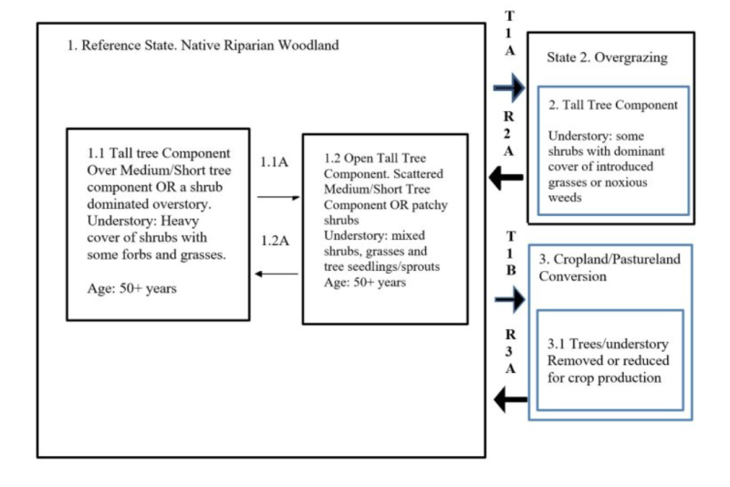
State 1
Reference
In its native state riparian woodlands have a dynamic mix of either a tall tree component mixed with a medium or short tree component and understory of dense shrubs with grasses, sedges, and forbs. In drier areas the dominant overstory will be shrubs or shrubby willows. Mortality can occur through natural influences such as insects, disease, floods, and fire. Low intensity ground fires will open these riparian woodlands, however will recover quickly through root sprouting or seed regeneration. Severe fires can kill much of the vegetation and may take longer to recover if native seed sources are scarce or adjacent land uses impact these areas through intensive grazing, erosion from crop production, and invasion of introduced or exotic species. Below is a list of species that may be encountered in these MLRAs. Black Cottonwood and quaking aspen will be seen throughout the region if moisture is plentiful. Ponderosa pine more prevalent in the north areas and in the Palouse. Oregon White Oak is unique to the Yakima and Klickitat area. Black hawthorn is well adapted to the Palouse region. White alder and netleaf hackberry common in the Southeastern portion of the state. The junipers will be suited to the driest portions of these MLRAs. The short willows and shrubs will occur throughout the state. For specific plant lists relative to riparian plant associations in Washington MLRAs refer to the following references: Riparian Vegetation Classification of the Columbia Basin, WA. Rex C Crawford, Ph.D. March 2003 Washington Natural Heritage Program. Washington Dept. of Natural Resources in Coordination with Bureau of Land Management, Spokane, WA and the Nature Conservancy Trees and Shrubs for Riparian Plantings. USDA, NRCS Washington. Plant Materials Technical Note 24. Key Tall Tree Species Black Cottonwood (Populus balsamifera spp. Trichocarpa) Quaking Aspen (Populus tremuloides) Ponderosa pine (Pinus ponderosa) Oregon White Oak (Quercus garryana) Water Birch (Betula occidentalis) Medium/short Tree Species White Alder (Alnus rhombifolia) Thinleaf Alder (Alnus incana spp. tenuifolia) Black Hawthorn (Crataegus douglasii) Rocky Mt. Juniper (Juniperus scopulorum) Western Juniper (Juniperus occidentalis) Netleaf Hackberry (Celtis laevigata var. reticulata) Willow spp. (Salix spp.) Shrub Species Snowberry (Symphoricarpos albus) Red Osier Dogwood (Cornus sericea ssp. sericea) Mockorange (Philadelphus lewisii) Narrowleaf Willow (Salix exigua) Wood’s Rose (Rosa woodsia) Chokecherry (Prunus virginiana) Serviceberry (Amelanchier alnifolia) Oceanspray (Holodiscus discolor) Big Sagebrush (Artemisia tridentata).
Community 1.1
Tall Tree Over Medium and Short Tree or Shrub Dominated Overstory
Understory: Heavy cover of shrubs with some forbs and grasses This would be the non-disturbed Reference Plant Community with a tall tree overstory with a possible mid-level canopy of medium or short trees. A heavy cover of shrubs will be in the understory along with some native grasses, sedges, and forbs. Drier areas will not have a tall or medium tree component. These areas will be dominated by shrubs or shrubby willows. Mortality will occur through natural processes such as insects, disease, floods, and low intensity ground fires. If not impacted by outside influences such as overgrazing, land use change, or severed fire these riparian woodlands will recover through tree/shrub root sprouting or seed.
Community 1.2
Open Tall Tree, Scattered Medium and Short Tree, or Patchy Shrubs
Understory: Mixed Shrubs, Grasses, and Tree Seedlings/Sprouts. Tall Tree canopy is opened up with some mortality. Medium tree mid-level canopy and understory shrub cover is reduced. Site will recover quickly with tree/shrub root sprouting or through seed. Native Grass and forb cover may increase. Site recovery will depend on adjacent land use not influencing riparian area with invasion of exotic species, overgrazing, and riparian area removal or reduction.
Pathway 1.1A
Community 1.1 to 1.2
Low intensity ground fire opens up understory. Some tall tree, medium/short tree, and shrubs killed. Tree overstory canopy is opened up. Grasses and forbs may increase.
Pathway 1.2A
Community 1.2 to 1.1
Tree/shrub sprouts increase. Some trees/shrubs increase by seed. Grasses and forbs reduced as tree/shrub overstory advances.
State 2
Overgrazed
Riparian woodland subjected to frequent grazing in spring and early summer causing loss of native shrubs, grasses, and forbs. Tall, medium, and short tree components become stressed and some mortality occurs. The overstory tree component becomes more open allowing introduce grasses and noxious weeds to enter and compete with native species.
Community 2.1
Tall Tree, Introduced Grass, and Noxious Weeds
Open stand of overstory trees over mix of native shrubs and introduced cool-season grasses or noxious weeds. Little or no tree/shrub sprout or seedling development.
State 3
Cropland or Pasture
Many riparian woodland areas of MLRAs 007X, 008X, and 009X have been removed or their widths reduced for crop production. The Palouse Area would be a good example with riparian areas of black hawthorn, ponderosa pine, snowberry, and other native shrubs that have been removed or reduced.
Community 3.1
Cropland
Riparian woodland removed or reduced leaving a narrow strip of trees, shrubs, and grass.
Transition T1A
State 1 to 2
Overgrazing severely reduce native shrubs, grasses and forbs. Introduced cool-season grasses invade and dominate understory. Tall tree component remains. Some medium/short tree components may still remain. No tree regeneration or root sprouts.
Transition T1B
State 1 to 3
Riparian converted to pasture or cropland land use. Trees removed. Riparian width reduced.
Restoration pathway R2A
State 2 to 1
Livestock exclusion with possible site preparation and tree/shrub planting and seeding of native species.
Restoration pathway R3A
State 3 to 1
Riparian forest buffer planted and livestock excluded. Seed understory to native grasses to minimize weed invasion.
Additional community tables
Interpretations
Supporting information
Approval
Kirt Walstad, 2/06/2025
Rangeland health reference sheet
Interpreting Indicators of Rangeland Health is a qualitative assessment protocol used to determine ecosystem condition based on benchmark characteristics described in the Reference Sheet. A suite of 17 (or more) indicators are typically considered in an assessment. The ecological site(s) representative of an assessment location must be known prior to applying the protocol and must be verified based on soils and climate. Current plant community cannot be used to identify the ecological site.
| Author(s)/participant(s) | |
|---|---|
| Contact for lead author | |
| Date | 01/30/2025 |
| Approved by | Kirt Walstad |
| Approval date | |
| Composition (Indicators 10 and 12) based on | Annual Production |
Indicators
-
Number and extent of rills:
-
Presence of water flow patterns:
-
Number and height of erosional pedestals or terracettes:
-
Bare ground from Ecological Site Description or other studies (rock, litter, lichen, moss, plant canopy are not bare ground):
-
Number of gullies and erosion associated with gullies:
-
Extent of wind scoured, blowouts and/or depositional areas:
-
Amount of litter movement (describe size and distance expected to travel):
-
Soil surface (top few mm) resistance to erosion (stability values are averages - most sites will show a range of values):
-
Soil surface structure and SOM content (include type of structure and A-horizon color and thickness):
-
Effect of community phase composition (relative proportion of different functional groups) and spatial distribution on infiltration and runoff:
-
Presence and thickness of compaction layer (usually none; describe soil profile features which may be mistaken for compaction on this site):
-
Functional/Structural Groups (list in order of descending dominance by above-ground annual-production or live foliar cover using symbols: >>, >, = to indicate much greater than, greater than, and equal to):
Dominant:
Sub-dominant:
Other:
Additional:
-
Amount of plant mortality and decadence (include which functional groups are expected to show mortality or decadence):
-
Average percent litter cover (%) and depth ( in):
-
Expected annual annual-production (this is TOTAL above-ground annual-production, not just forage annual-production):
-
Potential invasive (including noxious) species (native and non-native). List species which BOTH characterize degraded states and have the potential to become a dominant or co-dominant species on the ecological site if their future establishment and growth is not actively controlled by management interventions. Species that become dominant for only one to several years (e.g., short-term response to drought or wildfire) are not invasive plants. Note that unlike other indicators, we are describing what is NOT expected in the reference state for the ecological site:
-
Perennial plant reproductive capability:
Print Options
Sections
Font
Other
The Ecosystem Dynamics Interpretive Tool is an information system framework developed by the USDA-ARS Jornada Experimental Range, USDA Natural Resources Conservation Service, and New Mexico State University.
Click on box and path labels to scroll to the respective text.