
Natural Resources
Conservation Service
Ecological site R008XY435WA
Loamy 14-20 PZ Goldendale Prairie
Last updated: 5/23/2025
Accessed: 06/13/2025
General information
Provisional. A provisional ecological site description has undergone quality control and quality assurance review. It contains a working state and transition model and enough information to identify the ecological site.
MLRA notes
Major Land Resource Area (MLRA): 008X–Columbia Plateau
MLRA 8 encompasses about 50,100 square kilometers mainly in Washington and Oregon, with a small area in Idaho. This MLRA is characterized by loess hills, surrounding scablands, and alluvial deposits. This MLRA consists mostly of Miocene Columbia River Basalt covered with up to 200 feet of loess and volcanic ash. The dominant soil order in this MLRA is Mollisols. Soils in this MLRA dominantly have a mesic temperature regime, a xeric moisture regime, and mixed minerology.
Classification relationships
Major Land Resource Area (MLRA): 8 – Columbia Plateau
LRU – Common Resource Areas (CRA):
8.5 - Moist Yakima Folds
Ecological site concept
Note: For MLRA 8 there are four ecological sites with the name “Loamy’.
1. One for the sagebrush steppe region
2. One specifically for grasslands on Goldendale Prairie (Klickitat Co.)
3. One specifically for grasslands on south side of Columbia Hills (Klickitat Co.)
4. One for other grassland regions in MLRA 8
a. SE portion of MLRA 8 includes portions of Adams, Franklin, Walla Walla, Asotin, Columbia and Garfield Counties
b. Area above Coulee Dam in Douglas Co.
The Loamy ESD below is for the grasslands on the Goldendale Prairie in Klickitat Co. (see 2 above).
Diagnostics:
The soils for this upland site are 20 inches and deeper with a loamy surface texture and limited rock fragments (generally 10 percent or less) in the root-growing portions of the soil profile. Silt loam soils are most common, but a variety of soils and landforms are possible. This Loamy is found on flat areas and west, east and south slopes.
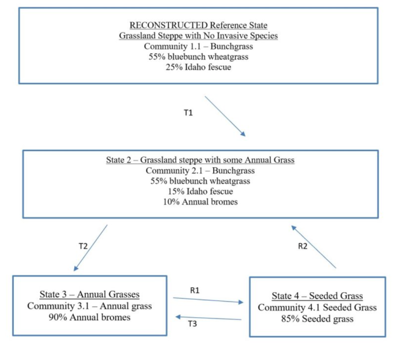
Note: due to historic farming and grazing the Goldendale Prairie has been heavily disturbed. No pristine remnant is known, so the reference state has been reconstructed based on experience in MLRA 8.
The Goldendale Prairie is a grassland steppe area and has not had sagebrush for more than 50 years and is not expected to have sagebrush. This area does not have sagebrush, nor bitterbrush, and no rabbitbrush except for one small area in a road cut.
Perennial bunchgrasses would dominate the Reference state. Cool-season bunchgrasses form two distinct layers. Bluebunch wheatgrass (Pseudoroegneria spicata) would be the dominant bunchgrass in the top grass layer, with Idaho fescue (Festuca idahoensis) as sub-dominant. Sandberg bluegrass (Poa secunda) would be the major grass of the lower grass layer. Native forbs would fill the interspaces.
Principle Vegetative Drivers:
The moderately deep to deep silt loam soils drive the vegetative expression of this productive site. Most species have unrestricted rooting. Loamy 14-20 PZ Goldendale Prairie has enough moisture for Idaho fescue to assume a sub-dominate role.
Associated Sites:
In the Goldendale Prairie portion of MLRA 8, Loamy and North Aspect (both 14 to 20 inch PZ) are closely associated. Stony Foothills, Stony Foothills South Aspect, Very Shallow and Riparian Complex may also be nearby.
Similar Sites:
Loamy on the Goldendale Prairie has higher precipitation (14 to 20-inch) with more Idaho fescue than the other Loamy ecological sites in MLRA 8.
Associated sites
R008XY455WA |
Loamy North Aspect 14-20 PZ Goldendale Prairie |
---|---|
R008XY220WA |
Stony Foothills bitterbrush |
R008XY226WA |
Stony Foothills South Aspect bitterbrush |
R008XY001WA |
Very Shallow |
R008XY720WA |
Riparian Complex |
Similar sites
R008XY101WA |
Dry Loamy 10-16 PZ |
---|
Table 1. Dominant plant species
Tree |
Not specified |
---|---|
Shrub |
Not specified |
Herbaceous |
(1) Pseudoroegneria spicata |
Physiographic features
The landscape is part of the Columbia basalt plateau. Loamy 14-20PZ Goldendale Prairie sites occur on broad ridges and plateaus, stream terrace in Klickitat County.
Physiographic Division: Intermontane Plateau
Physiographic Province: Columbia Plateau
Physiographic Sections: Walla Walla Plateau Section
Landscapes: Hills and plateaus
Landform: Sideslopes, terraces, alluvial fans
Table 2. Representative physiographic features
Geomorphic position, hills |
(1) Side Slope |
---|---|
Landforms |
(1)
Hills
(2) Plateau (3) Terrace (4) Alluvial fan |
Flooding frequency | None |
Ponding frequency | None |
Elevation | 305 – 914 m |
Slope | 2 – 30% |
Water table depth | 152 cm |
Aspect | W, NW, N, NE, E, SE, S, SW |
Table 3. Representative physiographic features (actual ranges)
Flooding frequency | Not specified |
---|---|
Ponding frequency | Not specified |
Elevation | 244 – 975 m |
Slope | 2 – 65% |
Water table depth | Not specified |
Climatic features
Grasslands do not have shrubs because they receive more spring precipitation especially in March (Daubenmire). The climate is characterized by moderately cold, wet winters, and hot, dry summers, with limited precipitation due to the rain shadow effect of the Cascades. Taxonomic soil climate is xeric moisture regime with a mesic temperature regime.
Table 4. Representative climatic features
Frost-free period (characteristic range) | 120-150 days |
---|---|
Freeze-free period (characteristic range) | |
Precipitation total (characteristic range) | 356-508 mm |
Frost-free period (actual range) | 110-160 days |
Freeze-free period (actual range) | |
Precipitation total (actual range) |
Influencing water features
A plant’s ability to grow on a site and overall plant production is determined by soil-water-plant relationships:
1. Whether rain and melting snow run off-site or infiltrates into the soil
2. Whether soil conditions remain aerobic or become saturated and become anaerobic
3. Water drainage and how quickly the soil reaches the wilting point
With adequate cover of live plants and litter, there are no restrictions on Loamy sites with water infiltrating into the soil. These sites are well drained and are saturated for only a short period.
Soil features
The ecological site's components are dominantly Ultic and Typic taxonomic subgroups of Haploxerolls, Durixerolls and Argixerolls great groups of the Mollisols taxonomic order. Soils are moderately deep to very deep. Average available water capacity of about seven inches (17.8 cm) in the zero to 40 inches (zero to100 cm) depth range.
Soil parent material is dominantly loess mixed with colluvium and residuum with the influence of volcanic ash possible.
The associated soils are Goldendale, Niva and similar soils.
Dominant soil surface is silt loam.
Dominant particle-size class is clayey to fine-loamy.
Table 5. Representative soil features
Parent material |
(1)
Loess
(2) Colluvium (3) Residuum |
---|---|
Surface texture |
(1) Silt loam |
Family particle size |
(1) Clayey (2) Fine-loamy |
Drainage class | Well drained |
Depth to restrictive layer | 51 – 152 cm |
Soil depth | 152 cm |
Surface fragment cover <=3" | 5% |
Surface fragment cover >3" | 0% |
Available water capacity (0-101.6cm) |
17.78 cm |
Calcium carbonate equivalent (Depth not specified) |
0% |
Electrical conductivity (Depth not specified) |
0 mmhos/cm |
Sodium adsorption ratio (Depth not specified) |
0 |
Soil reaction (1:1 water) (0-25.4cm) |
5.6 – 7.3 |
Subsurface fragment volume <=3" (Depth not specified) |
5% |
Subsurface fragment volume >3" (Depth not specified) |
0% |
Table 6. Representative soil features (actual values)
Drainage class | Not specified |
---|---|
Depth to restrictive layer | Not specified |
Soil depth | Not specified |
Surface fragment cover <=3" | 0 – 10% |
Surface fragment cover >3" | 0 – 5% |
Available water capacity (0-101.6cm) |
8.64 – 20.83 cm |
Calcium carbonate equivalent (Depth not specified) |
Not specified |
Electrical conductivity (Depth not specified) |
Not specified |
Sodium adsorption ratio (Depth not specified) |
Not specified |
Soil reaction (1:1 water) (0-25.4cm) |
Not specified |
Subsurface fragment volume <=3" (Depth not specified) |
0 – 15% |
Subsurface fragment volume >3" (Depth not specified) |
0 – 5% |
Ecological dynamics
Loamy 14-20 PZ Goldendale Prairie produces about 800 to 1,200 pounds per acre of biomass annually.
The line between sagebrush steppe and true grasslands has been discussed and debated for many years. Daubenmire states that the line has nothing to do with pre-settlement as native ungulates played no significant role in the evolution of ecotypes. He also says that there is no evidence that the distribution of vegetative types is related to fire. And he also says there is no useful correlation between soil classification and the line between grasslands and sagebrush steppe.
The ecotones between Daubenmire’s vegetation types can be defined on the basis of consistent differences in climate and consistent differences in vegetation. Higher spring precipitation, especially in March, favors grasses over sagebrush. The grassland area of southeastern Adams and eastern Franklin counties have more precipitation in March. The same for the grasslands in Walla Walla, Asotin and Garfield counties. The Goldendale Prairie and the high elevation grassland above Coulee Dam in Douglas county also have higher spring precipitation. So, the grassland areas of MLRA 8 are consistent with Daubenmire’s findings.
Bluebunch wheatgrass would dominate the Loamy ecological site with Idaho fescue as sub-dominate. Both species are long-lived, mid-sized bunchgrasses. Idaho fescue is shorter and has a dense clump of shoots, while bluebunch wheatgrass is taller and is less dense. Bluebunch has an awned spike seedhead while Idaho fescue has an awned panicle seedhead.
Both grasses provide a crucial and extensive network of roots to the upper portions (up to 48 inches deep in soils with no root-restrictive horizons) of the soil profile. These roots create a massive underground source to stabilize the soils, provide organic matter and nutrients inputs, and help maintain soil pore space for water infiltration and water retention in the soil profile. The extensive rooting system of mid-sized bunchgrasses leave very little soil niche space available for invasion by other species. This drought resistant root can compete with, and suppress, the spread of exotic weeds.
The stability and resiliency of the reference communities is directly linked to the health and vigor of bluebunch wheatgrass. Refer to pages 8 to 9 for more details about bluebunch physiology. Research has found that the community remains resistant to medusahead if the site maintains at least 0.8 mid-sized bunchgrass plant square feet (K. Davies, 2008). It is bluebunch that holds the system together. If we lose the bluebunch or Idaho fescue the ecosystem crashes or unravels.
The natural disturbance regime for grassland communities is periodic lightning-caused fires. Ponderosa pine communities have the shortest Fire Return Interval (FRI) of about 10 to 20 years (Miller). The FRI increases as one moves to wetter forested sites or to dries shrub steppe communities. Given the uncertainties and opinions of reviewers, a mean of 75 years was chosen for Wyoming sagebrush communities (Rapid Assessment Model). This would place the historic FRI for grassland steppe around 30 to 50 years
The effect of fire on the community depends upon the severity of the burn. With a light to moderate fire there can be a mosaic of burned and unburned patches. Bunchgrasses thrive as the fire does not get into the crown. With adequate soil moisture bluebunch wheatgrass can make tremendous growth the year after the fire. Largely, the community is not affected by lower intensity fire.
A severe fire puts stress on the entire community. Spots and areas that were completely sterilized are especially vulnerable to exotic invasive species. Sterilized spots must be seeded to prevent invasive species (annual grasses, tumble mustard) from totally occupying the site. Bluebunch wheatgrass and basin wildrye will have weak vigor for a few years but generally survive. Idaho fescue plants are very much at risk with a severe burn coupled with wind. The result can be “black holes” or ash two to three inches into the crown.
The death of Idaho fescue and Cusick bluegrass plants creates holes in the community, and the opportunity for exotic species to colonize. Needle and thread (Hesperostipa comata) is one native species that can increase via new seedlings.
Grazing is another common disturbance that occurs to this ecological site. Grazing pressure can be defined as heavy grazing intensity, or frequent grazing during reproductive growth, or season-long grazing (the same plants grazed more than once). As grazing pressure increases the plant community unravels in stages:
1. Cusick bluegrass is eliminated. Adjacent natives fill the void
2. Idaho fescue declines while bluebunch wheatgrass increases
3. Both Idaho fescue and bluebunch wheatgrass decline
4. With further decline invasive species colonize the site
5. The site can become an invasive grass community
Managing grasslands to improve the vigor and health of native bunchgrasses begins with an understanding of grass physiology. New growth each year begins from basal buds. Bluebunch wheatgrass plants rely principally on tillering, rather than establishment of new plants through natural reseeding. During seed formation, the growing points become elevated and are vulnerable to damage or removal.
If defoliated during the formation of seeds, bluebunch wheatgrass has limited capacity to tiller compared with other, more grazing-resistant grasses (Caldwell et al., 1981). Repeated critical period grazing (boot stage through seed formation) is especially damaging. Over several years each native bunchgrass pasture should be rested during the critical period two out of every three years (approximately April 15 to July 15). And each pasture should be rested the entire growing season every third year (approximately March 1 to July 15).
In the spring each year it is important to monitor and maintain adequate top growth: (1) so plants have enough energy to replace basal buds annually, (2) to optimize regrowth following spring grazing, 3) to protect the elevated growing points of bluebunch wheatgrass, and (4) to avoid excessive defoliation of Idaho fescue with its weak stems.
Bluebunch wheatgrass and Idaho fescue remain competitive if:
(1) Basal buds are replaced annually,
(2) Enough top-growth is maintained for growth and protection of growing points, and
(3) The timing of grazing and non-grazing is managed over a several-year period. Careful management of late spring grazing is especially critical
For more grazing management information refer to Range Technical Notes found in Section I Reference Lists of NRCS Field Office Technical Guide for Washington State.
In Washington, bluebunch wheatgrass communities provide habitat for a variety of upland wildlife species.
State and transition model

More interactive model formats are also available.
View Interactive Models
More interactive model formats are also available.
View Interactive Models
Click on state and transition labels to scroll to the respective text
State 1 submodel, plant communities
State 2 submodel, plant communities
State 3 submodel, plant communities
State 4 submodel, plant communities
State 1
Historical Reference
Note: most sites on the Goldendale Prairie have already crossed the threshold into State 3 State 1 Narrative: State 1 represents grassland steppe with no invasive or exotic weed species. Each functional, structural group has one or more native species. The Goldendale Prairie has no sagebrush or bitterbrush, and except for a spot along a road cut, also has no rabbitbrush. Reference State Communities: 1.1 Reference Bluebunch wheatgrass-Idaho fescue. Dominate Reference State Species: Bluebunch wheatgrass and Idaho fescue. At-risk Communities: • Note: most sites on the Goldendale Prairie have already crossed the threshold into State 3 Pathways within State 1 There are no pathways in Reference State for this grassland steppe Loamy ecological site.
Community 1.1
Reference Bluebunch Wheatgrass and Idaho Fescue
55% bluebunch wheatgrass 25% Idaho fescue
Figure 1. Annual production by plant type (representative values) or group (midpoint values)
State 2
Current Potential Grassland Steppe with some Annual Grass
Note: most sites on the Goldendale Prairie have already crossed the threshold into State 3 State 2 Narrative: State 2 represents grassland steppe with the inclusion of invasive annual grasses such as annual bromes. All the native functional, structural groups are still represented by one or more species. Annual grasses are a minor component in State 2. Once a community has been invaded by cheatgrass the chance of going back to State 1 is small. Dominant State 2 Species: Bluebunch wheatgrass and Idaho fescue Community for State 2: 2.1 Bunchgrass Bluebunch wheatgrass In Community and 2.1, the reference community has been invaded by some annual grasses such as annual bromes. Annual grasses are a minor component in State 2. Once a community has been invaded by cheatgrass the chance of going back to State 1 is small. Pathways within State 2 There are no pathways in State 2 for this grassland steppe Loamy ecological site.
Community 2.1
Bluebunch Wheatgrass, Idaho Fescue, and Annual Bromes
55% bluebunch wheatgrass 15% Idaho fescue 10% annual bromes
State 3
Annual Grasses
Note: most sites on the Goldendale Prairie have already crossed the threshold into State 3 State 3 Narrative: State 3 represents sites dominated by invasive annual species and has crossed a biological threshold. As State 1 or State to unravels the dominant bunchgrasses decline while invasive grasses become more and more prominent. Virtually all the native functional, structural groups are missing in State 3. Community Phases for State 3: 3.1 Annual Grass annual bromes Dominate State 3 Species: Cheatgrass Other important invasive species can include medusahead, ventenata, mustard, prickly lettuce and diffuse knapweed. Pathways within State 3 There are no pathways in State 3 for this grassland steppe Loamy ecological site.
Community 3.1
Annual Grass
90% annual bromes
State 4
Seeded Grass
State 4 represents a site that has been seeded to desirable grasses such as Secar Snake River wheatgrass, Sherman big bluegrass, or intermediate wheatgrass. State 4 is stable if 0.8 plant per sq. ft. or greater of the desired bunchgrasses is maintained. Community for State 4: 4.1 Seeded Grasses. Dominant State 4 Species: Desirable seeded grasses with or without legumes Pathways within State 4: There are no pathways in State 4 for this grassland steppe Loamy ecological site.
Community 4.1
Seeded Grass
85% seeded grass
Transition T1A
State 1 to 2
Note: most sites on the Goldendale Prairie have already crossed the threshold into State 3 Transitions from State to State T1A Result: transition from Reference State to State 2 (grassland steppe with a few annuals). The Reference State does not have invasive species. State 2 has the same communities but with minor additions of invasive annual grasses such as annual bromes. Ecological process. Most sites in the Reference State have some scattered annual grass seed that has blown onto the site. This seed is waiting for seed-to-soil contact to enable germination. Primary Trigger: Soil disturbances from rodents or badgers. Indicators: The occurrence of annual grasses on sites where they had been absent.
Transition T2A
State 2 to 3
Result: Transition from State 2 to State 3 which is dominated by annuals. This transition occurs once the cover of bluebunch wheatgrass-Idaho fescue declines to less than 10 percent while invasive species cover is 40 percent or more. Primary Trigger: Chronic heavy grazing, season-long grazing, or late spring grazing. Note: chronic season-long grazing in the 1880s to 1940s created thousands of acres of annual grass dominated communities. Ecological Process: Consistent defoliation pressure to bluebunch wheatgrass and Idaho fescue causes poor vigor, shrinking crowns and plant mortality. Native species are all but eliminated while invasive species such as annual bromes have the competitive advantage. With more and more of the soil surface and upper soil rooting surface open, opportunistic, exotic weeds take advantage of the available niche space to colonize and expand until they dominate the community. The site has lost its primary species that stabilize and protect the soil from wind and water erosion and has also lost the ability to retain sufficient soil moisture for many of the native perennial species. Indicators: Decreasing cover of bluebunch wheatgrass and Idaho fescue, increasing cover of invasive annual species. Increasing distance between bunchgrass plants. Decreasing soil organic matter, soil water retention, limited water infiltration and percolation in the soil profile
Restoration pathway R3A
State 3 to 4
Transition from State 3 (a community dominated by invasive annual species) to State 4, which is predominately desirable seeded grasses. This restoration transition does not occur without significant time and inputs to control weeds, prepare a seedbed, seed desirable species, and post-seeding weed control and management. This requires a commitment of two years or more for weed control. Care must be taken to maintain soil structure so that the seedbed has many safe sites for the seed. Seed placement must be managed to achieve seed-soil contact at very shallow depth (about 1/8 inch is desired). Proper grazing management is essential to maintain the stand post-seeding. Secar Snake River wheatgrass, thickspike wheatgrass, Sherman big bluegrass, Sandberg bluegrass, and intermediate wheatgrass are typical species seeded on Loamy ecological site. The actual transition occurs when the seeded species have successfully established and are outcompeting the annual species for cover and dominance of resources.
Restoration pathway R4A
State 4 to 2
Result: Shift from State 4 back to State 2. This restoration transition does not occur without a significant commitment of time & resource inputs to restore ecological processes, native bunchgrasses and native forb species. Shifting from State 3 to State 4 to State 2: If the goal is to restore back to a native plant community, State 3 must first be shifted to State 4. It will take two years or longer to kill annual species and to exhaust the seedbank of invasive species. Site will then need to be seeded to perennial species such as Snake River wheatgrass to restore soil properties before native species can survive and thrive on site. The seeded species rebuild some of the basic soil properties including increased soil organic matter, increased soil moisture, and likely would also require the soil’s pore spaces, bulk density and soil microorganisms to return before the native species that used to survive in this ecological site can return. The site would also need several years of no significant fires and proper grazing management as well. See narrative for R1A transition above. Shifting from State 4 to State 2: This assumes that the shift from State 3 to State 4 has been successful. State 4 stand must be killed before proceeding. The seeding of native species should occur in two steps: (1) a seeding of native bunchgrasses so that broadleaf weeds may be controlled, (2) a re-introduction of native forbs. The site would also need several years of no significant fires and proper grazing management as well to ensure plant establishment and vigor.
Transition T4A
State 4 to 3
Result: shift from seeded grass State 4 to State 3 which is dominated by invasive annual species. Primary Trigger: This transition occurs when chronic heavy grazing has removed too much of the perennial bunchgrass cover allowing invasive annual species to colonize the site. As this continues the competitive advantage goes to the exotic species which are opportunistic and take most of the site’s resources. Little of the resources remain for the desirable species. Secondary Trigger: Frequent fires or a severe fire that removes too much of the perennial bunchgrass cover and gives the competitive advantage back to the invasive species. Indicators: shrinking crowns and mortality of desirable species, increasing caps gaps between perennial species, increasing cover by annual grasses.
Additional community tables
Table 7. Community 1.1 plant community composition
Group | Common name | Symbol | Scientific name | Annual production (kg/hectare) | Foliar cover (%) | |
---|---|---|---|---|---|---|
Shrub/Vine
|
||||||
1 | Sprouting Shrubs - Minor | 45– | ||||
currant | RIBES | Ribes | – | – | ||
rose | ROSA5 | Rosa | – | – | ||
Grass/Grasslike
|
||||||
2 | Dominant Mid-Size Bunchgrasses | 1065– | ||||
bluebunch wheatgrass | PSSP6 | Pseudoroegneria spicata | 729– | – | ||
Idaho fescue | FEID | Festuca idahoensis | 336– | – | ||
3 | Other Mid-Size Bunchgrasses - Minor | 45– | ||||
squirreltail | ELEL5 | Elymus elymoides | – | – | ||
Thurber's needlegrass | ACTH7 | Achnatherum thurberianum | – | – | ||
needle and thread | HECOC8 | Hesperostipa comata ssp. comata | – | – | ||
Cusick's bluegrass | POCU3 | Poa cusickii | – | – | ||
Columbia needlegrass | ACNE9 | Achnatherum nelsonii | – | – | ||
basin wildrye | LECI4 | Leymus cinereus | – | – | ||
prairie Junegrass | KOMA | Koeleria macrantha | – | – | ||
4 | Short Grass - Minor | 135– | ||||
Sandberg bluegrass | POSE | Poa secunda | – | – | ||
Forb
|
||||||
5 | Native Forbs - Minor | 135– | ||||
arrowleaf balsamroot | BASA3 | Balsamorhiza sagittata | – | – | ||
lupine | LUPIN | Lupinus | – | – | ||
hawksbeard | CREPI | Crepis | – | – | ||
longleaf phlox | PHLO2 | Phlox longifolia | – | – | ||
spiny phlox | PHHO | Phlox hoodii | – | – | ||
granite prickly phlox | LIPU11 | Linanthus pungens | – | – | ||
buckwheat | ERIOG | Eriogonum | – | – | ||
Indian paintbrush | CASTI2 | Castilleja | – | – | ||
silverpuffs | MICRO6 | Microseris | – | – | ||
yellow fritillary | FRPU2 | Fritillaria pudica | – | – | ||
fleabane | ERIGE2 | Erigeron | – | – | ||
desertparsley | LOMAT | Lomatium | – | – | ||
milkvetch | ASTRA | Astragalus | – | – | ||
hawkweed | HIERA | Hieracium | – | – | ||
mariposa lily | CALOC | Calochortus | – | – | ||
woolly plantain | PLPA2 | Plantago patagonica | – | – | ||
western stoneseed | LIRU4 | Lithospermum ruderale | – | – | ||
trumpet | COLLO | Collomia | – | – | ||
larkspur | DELPH | Delphinium | – | – | ||
low pussytoes | ANDI2 | Antennaria dimorpha | – | – |
Interpretations
Supporting information
Other references
Boling M., Frazier B., Busacca, A., General Soil Map of Washington, Washington State University, 1998 Daubenmire, R., Steppe Vegetation of Washington, EB1446, March 1968
Davies, Kirk, Medusahead Dispersal and Establishment in Sagebrush Steppe Plant Communities, Rangeland Ecology & Management, 2008 Environmental Protection Agency, map of Level III and IV Ecoregions of Washington, June 2010
Miller, Baisan, Rose and Pacioretty, “Pre and Post Settlement Fire regimes in mountain Sagebrush communities: The Northern Intermountain Region Natural Resources Conservation Service, map of Common Resource Areas of Washington, 2003 Rapid Assessment Reference Condition Model for Wyoming sagebrush, LANDFIRE project, 2008
Rocchio, Joseph & Crawford, Rex C., Ecological Systems of Washington State. A Guide to Identification. Washington State Department of Natural Resources, October 2015. Pages 156-161 Inter-Mountain Basin Big Sagebrush
Rouse, Gerald, MLRA 8 Ecological Sites as referenced from Natural Resources Conservation Service-Washington FOTG, 2004 Soil Conservation Service, Range Sites for MLRA 8 from 1980s and 1990s
Tart, D., Kelley, P., and Schlafly, P., Rangeland Vegetation of the Yakima Indian reservation, August 1987, YIN Soil and Vegetation Survey
Contributors
Kevin Guinn
Approval
Kirt Walstad, 5/23/2025
Acknowledgments
Contributors
Provisional Site Author: Kevin Guinn
Technical Team: K. Moseley, G. Fults, R. Fleenor, W. Keller, C. Smith, K. Bomberger, C. Gaines, K. Paup-Lefferts
Rangeland health reference sheet
Interpreting Indicators of Rangeland Health is a qualitative assessment protocol used to determine ecosystem condition based on benchmark characteristics described in the Reference Sheet. A suite of 17 (or more) indicators are typically considered in an assessment. The ecological site(s) representative of an assessment location must be known prior to applying the protocol and must be verified based on soils and climate. Current plant community cannot be used to identify the ecological site.
Author(s)/participant(s) | |
---|---|
Contact for lead author | |
Date | 05/08/2025 |
Approved by | Kirt Walstad |
Approval date | |
Composition (Indicators 10 and 12) based on | Annual Production |
Indicators
-
Number and extent of rills:
-
Presence of water flow patterns:
-
Number and height of erosional pedestals or terracettes:
-
Bare ground from Ecological Site Description or other studies (rock, litter, lichen, moss, plant canopy are not bare ground):
-
Number of gullies and erosion associated with gullies:
-
Extent of wind scoured, blowouts and/or depositional areas:
-
Amount of litter movement (describe size and distance expected to travel):
-
Soil surface (top few mm) resistance to erosion (stability values are averages - most sites will show a range of values):
-
Soil surface structure and SOM content (include type of structure and A-horizon color and thickness):
-
Effect of community phase composition (relative proportion of different functional groups) and spatial distribution on infiltration and runoff:
-
Presence and thickness of compaction layer (usually none; describe soil profile features which may be mistaken for compaction on this site):
-
Functional/Structural Groups (list in order of descending dominance by above-ground annual-production or live foliar cover using symbols: >>, >, = to indicate much greater than, greater than, and equal to):
Dominant:
Sub-dominant:
Other:
Additional:
-
Amount of plant mortality and decadence (include which functional groups are expected to show mortality or decadence):
-
Average percent litter cover (%) and depth ( in):
-
Expected annual annual-production (this is TOTAL above-ground annual-production, not just forage annual-production):
-
Potential invasive (including noxious) species (native and non-native). List species which BOTH characterize degraded states and have the potential to become a dominant or co-dominant species on the ecological site if their future establishment and growth is not actively controlled by management interventions. Species that become dominant for only one to several years (e.g., short-term response to drought or wildfire) are not invasive plants. Note that unlike other indicators, we are describing what is NOT expected in the reference state for the ecological site:
-
Perennial plant reproductive capability:
Print Options
Sections
Font
Other
The Ecosystem Dynamics Interpretive Tool is an information system framework developed by the USDA-ARS Jornada Experimental Range, USDA Natural Resources Conservation Service, and New Mexico State University.
Click on box and path labels to scroll to the respective text.