Natural Resources
Conservation Service
Ecological site R008XY988WA
Wetland Complex
Last updated: 5/23/2025
Accessed: 04/10/2026
General information
Provisional. A provisional ecological site description has undergone quality control and quality assurance review. It contains a working state and transition model and enough information to identify the ecological site.
MLRA notes
Major Land Resource Area (MLRA): 008X–Columbia Plateau
MLRA 8 encompasses about 50,100 square kilometers mainly in Washington and Oregon, with a small area in Idaho. This MLRA is characterized by loess hills, surrounding scablands, and alluvial deposits. This MLRA consists mostly of Miocene Columbia River Basalt covered with up to 200 feet of loess and volcanic ash. The dominant soil order in this MLRA is Mollisols. Soils in this MLRA dominantly have a mesic temperature regime, a xeric moisture regime, and mixed minerology.
Classification relationships
Major Land Resource Area (MLRA): 8 – Columbia Plateau
LRU – Common Resource Areas (CRA):
8.1 - Channeled Scablands
8.2 - Loess Islands
8.3 - Okanogan Drift Hills
8.4 - Moist Pleistocene Lake Basins
8.5 - Moist Yakima Folds
8.6 - Lower Snake and Clearwater Canyons
8.7 - Okanogan Valley
Ecological site concept
In the upland setting ecological sites are often expansive, and thus, can be delineated and separated on aerial photos. But in the landscape position of bottoms, basins and depressions this is rarely the case as small changes in soil chemistry, the water table and elevation or aspect results in significant changes in plant community composition. In short distances there are often big swings of available water holding capacity, and soils can go from hydric to non-hydric, or from saline-sodic to not. So, in bottoms, riparian areas and depressions, ecological sites and community phases occur as small spots, strips and patches, or as narrow rings around vernal ponds. And generally, in a matter of steps one can walk across several ecological sites. On any given site location, two or more of these sites occur as a patchwork– Loamy Bottom, Alkali Terrace, Sodic Flat, Wet Meadow, Wetland Complex and Riparian Complex. These ecological sites may need to be mapped as a complex when doing resource inventory.
Diagnostics:
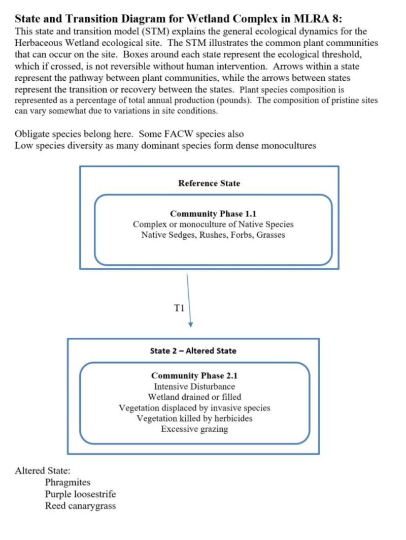
Wetland Complex in MLRAs 7, 8, and 9 is a bottomland site, is the “classic wetland” and is characterized by two conditions – hydric soil and aquatic plants. This small patch ecosystem sits on the lowest position of the landscape, on landforms such as depressions, bottoms, floodplains and basins. Wetland Complex also occurs on pond and lake fringes, and along slow-moving streams and rivers. These sites are so small they are indicated on a soil map as a spot symbol.
Wetland Complex is part of the lentic (standing water) ecosystem. Wetlands are frequently or continually inundated by up to two feet of water. Water level fluctuations support the development of different wetland zones (floating, submergent, emergent). This ecological site only considers the emergent vegetative zone of the wetland (where plants rise above the water surface). The floating and submergent zones are not considered in this description.
Soils are saturated to the surface or there is standing water for an extended portion of the growing season. Thus, the soils show all the signs of hydric soils such as mottling and greying. These saturated wetland soils are not saline or sodic but, are hydric. The soils are moderately deep to deep, silt loam or sandy loam texture.
These plant communities are exclusively herbaceous (non-woody) and predominately wetland obligate species. Cattails, bulrush, sedges, wetland grasses and Baltic rush are major species. Wetlands often have low species diversity as many of the dominant species form dense monocultures. Wetland Complex remains wet all season and rarely, if ever, burn.
A subset of this ecological site occurs around the edge of basalt pothole ponds. In addition to the herbaceous species, this subset can have woody species such as aspen, coyote willow, wood rose and hawthorn.
Principle Vegetative Drivers:
Prolonged saturated and anaerobic soil conditions drive the vegetative expression of Wetland Complex. Seasonal fluctuations in water levels control vegetation patterns. This site is dominated by hydrophytic species.
Associated Sites:
Wetland Complex is associated with other ecological sites in bottoms and basin areas of MLRA 8, including Loamy Bottom, Alkali Terrace, Sodic Flat, Wet Meadow and Riparian Complex. Wetland Complex is also associated with upland sites such as Loamy, Stony, and Cool Loamy.
Similar Sites:
MLRAs 7, 8, and 9 share the same Wetland Complex ecological site description.
Associated sites
| R008XY980WA |
Wet Meadow |
|---|---|
| R008XY720WA |
Riparian Complex |
| R008XY930WA |
Loamy Bottom |
| R008XY970WA |
Alkali Terrace |
| R008XY978WA |
Sodic Flat |
Similar sites
| R008XY980WA |
Wet Meadow |
|---|
Table 1. Dominant plant species
| Tree |
Not specified |
|---|---|
| Shrub |
Not specified |
| Herbaceous |
(1) Typha latifolia |
Click on box and path labels to scroll to the respective text.