Ecological dynamics
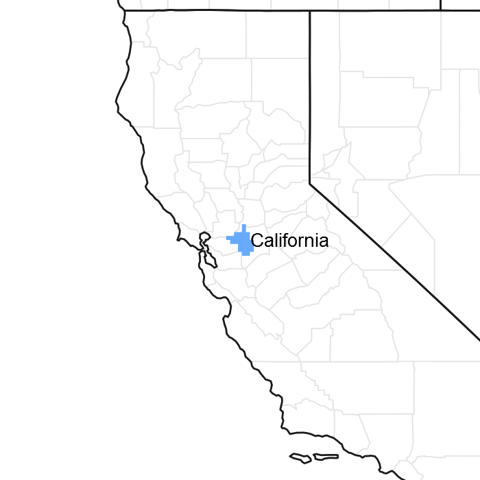
This ecological site historically would be represented by a complex series of comparatively high relief stable dunes in a mosaic pattern with 016XA001. Well sorted, discontinuously weakly cemented wind-deposited sands largely of granitic origin (Sierra Nevada) are the hallmark of the ecological site along the southern fringe of the western part of the LRU. Much of this site was historically occasionally inundated but due the high water table and capillary action of the sands, some salts have accumulated in the soil surface horizon and this site was able to support large amounts of saltgrass. Shrub species distribution across the site was likely largely dictated by the relative depth of the high water table. This site is of limited extent covering just 1% of the LRU near the city of Oakley, predominantly on Bethel and Jersey islands.
Almost all of this ecological site has been substantially altered from its pre-gold mining era conditions. This is largely due to levee construction and direct conversion to production agriculture. Most extents of the site not currently in agricultural production have been developed. Some areas retain the topography of low relief transverse dues but most of it has been partially leveled for Bermuda grass production. Areas without active management or grazing are dominated by annual grasses, most notably ripgut brome which grows to only a moderate height, presumably due to salts in the soil and the resulting water stress on the plants.
Coyote brush, salt fat hen and lupine were historically the most likely shrub components on this site although coyote brush currently occurs only incidentally. Other shrubs and trees present in the mosaic are more likely associated with the sister site 016XA001 on the lowest portions of the mosaic with willows frequently accompanied by cattails and blackberry there.
Currently, pumping of groundwater is necessary to keep much of the site from continuous inundation as a result of subsidence. It is assumed here that much of the subsidence associated with the ecological site has been in conjunction with the 016XA001 portion of the mosaic; surficial losses of organic matter, while comparatively trivial in quantity, are assumed to have occurred on nearly the entire ecological site due to historic tillage and land levelling efforts.
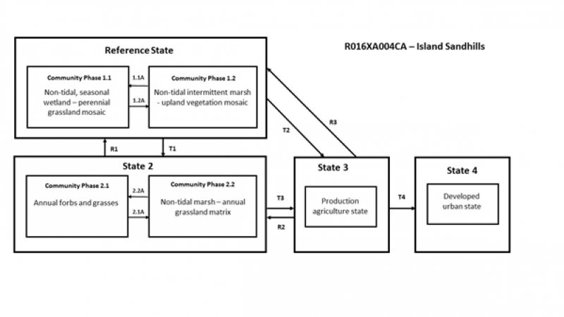
State 1
Reference State
Saltgrass, coyote brush, salt fat hen, poison oak and bush lupine typically dominate upland areas whereas the intergrade between histic 016XA001 and this site includes some groundwater fed wetland species, primarily Eleocharis and Juncus species. Wetland vegetation may expand upslope somewhat during very wet years and then contract to the lower elevation during years of poor rainfall. Some amount of organic matter accumulation within this zone is likely, but not to the extent demonstrated in 016XA001.
Community 1.1
Non-tidal, seasonal wetland perennial grassland mosaic
Saltgrass, coyote brush, poison oak and bush lupine; meadow barley, spike rushes and Juncus species in concavities.
Community 1.2
Non-tidal, intermittent marsh - upland vegetation mosaic
California meadow barley, spike rushes and Juncus species dominate with expanded range of occurence; bush lupine and coyote brush sparse or in patches with saltgrass restricting recruitment of young shrubs.
Pathway 1.2A
Community 1.1 to 1.2
Two or more wetter than normal climate years facilitating the expansion of wetland vegetation upslope from the community’s previous location.
Pathway 1.1A
Community 1.2 to 1.1
Prolonged drought causing reduction in wetland obligate species along the upper elevations of seasonal wetlands.
State 2
Modified Surface Hydrology
This state is most likely to occur in the form of small exclusions in odd field corners and other unmanaged areas. Following reclamation and the introduction of disturbance favored, grazing-adapted annual species, most of the drier portions of the ecological site would come to be dominated by such species with decreasing amounts of saltgrass in areas left ungrazed. Shrub species would be mostly reduced to trace amounts in such areas due to active control. At the lower elevation of this ecological site, facultative annual wetland species would likely compete heavily at the drying fringe, reducing the extent of dominance by historic species, but not excluding them altogether.
Community 2.1
Annual forbs and grasses
Ripgut brome, farmer’s foxtail, annual fescue, field bindweed, smooth cats ear, and to a lesser degree, saltgrass, poison hemlock and black mustard.
Community 2.2
Non-tidal marsh - annual grassland matrix
California meadow barley, spike rush, Juncus species, Mediterranean barley, scarlet pimpernel and saltgrass.
Pathway 2.1A
Community 2.1 to 2.2
Vegetation control such as mowing and grazing decreases competition for light and nutrients allowing the expansion of saltgrass and species adapted to moist to wet soil conditions such as meadow barley and spike rushes.
| Prescribed Grazing |
|
| Herbaceous Weed Control |
|
Pathway 2.2A
Community 2.2 to 2.1
Removal of vegetation controls such as grazing and mowing increases the composition of introduced annual species thereby displacing wetland species along the wetter portions of the ecological site and reducing the success of saltgrass in drier areas.
State 3
Agricultural Production
Active agricultural use, primarily for Bermuda grass production. The current typical grass crop is likely following previous annual wheat and other small grain cultivation.
State 4
Developed
Developed with structures and attending infrastructure. While restoration is conceptually possible, it has not been demonstrated economically feasible. Compared to other ecological sites within the LRU, this ecological site presents fewer immediate hazards to structures and lesser likelihood of full restoration and therefore are less likely to be targeted for restoration.
Transition T1
State 1 to 2
Levee installation, land levelling, burning, and cultivation; introduction of grazing-adapted annual vegetation species and brush control.
Transition T2
State 1 to 3
Levee installation, land levelling, burning, and annual cultivation; introduction of grazing-adapted annual vegetation species and brush control.
Restoration pathway R1
State 2 to 1
Restoration of natural hydrology, reintroduction of native species and control of competing non-native vegetation.
| Range Planting |
|
| Integrated Pest Management (IPM) |
|
| Tree/Shrub Establishment |
|
| Wetland Restoration |
|
Transition T3
State 2 to 3
Levee installation, land levelling, burning, and annual cultivation; introduction of grazing-adapted annual vegetation species and brush control. Primary difference between T2 and T3 is the degree of surface disturbance and loss of soil organic matter resulting from annual tillage.
Restoration pathway R3
State 3 to 1
Removal of cultivation practices, restoration of natural hydrology, reintroduction of native species and control of competing non-native vegetation.
| Range Planting |
|
| Drainage Water Management |
|
| Integrated Pest Management (IPM) |
|
| Tree/Shrub Establishment |
|
| Wetland Restoration |
|
Restoration pathway R2
State 3 to 2
Removal of cultivation practices.
Transition T4
State 3 to 4
Conversion to urban land use.


