Natural Resources
Conservation Service
Ecological site R023XY030NV
SOUTH SLOPE 8-12 P.Z.
Last updated: 4/10/2025
Accessed: 04/06/2026
General information
Provisional. A provisional ecological site description has undergone quality control and quality assurance review. It contains a working state and transition model and enough information to identify the ecological site.
Ecological site concept
Currently there is only a draft of the initial concept for this ecological site. The initial concept for this site places it within the Loamy Aridic Plateaus Low Production Wyoming and Lahontan Sagebrush sites w Sparse Juniper Ecological Site Group. To view the General STM and other information available for this ESG please go to https://edit.jornada.nmsu.edu/catalogs/esg/023X/R023XY910NV
This site is slightly more productive than the modal site with 300 lbs/ac in normal years. This site occurs on steep sideslopes of hills and plateaus on southerly aspects. The soils are typically shallow to very shallow, well drained and low available water capacity. Some soils have moderate to high amounts of gravel on the surface. More sunlight is received on the steep, south-facing, sideslopes of this site and the soils tend to warm and promote plant growth earlier in the spring but also have high evapotranspiration potentials. These soils have high potential for sheet and rill erosion and often evidence signs of active erosion. Desert needlegrass and bluebunch wheatgrass are codominant bunchgrasses in this site’s plant community. This site is written to have Wyoming big sagebrush, but site visits indicate a Lahontan sagebrush/antelope bitterbrush dominated community is possible, with the possibility of an Eroded State. This model is similar to the group modal site with four stable states.
Similar sites
| R023XY016NV |
SOUTH SLOPE 12-16 P.Z. PSSPS dominant grass; ARTRV dominant shrub; more productive site |
|---|---|
| R023XY039NV |
LOAMY SLOPE 10-14 P.Z. PSSPS dominant grass; more productive site |
| R023XY006NV |
LOAMY 8-10 P.Z. ACTH7 dominant grass; more productive site |
Table 1. Dominant plant species
| Tree |
Not specified |
|---|---|
| Shrub |
(1) Artemisia tridentata ssp. wyomingensis |
| Herbaceous |
(1) Achnatherum speciosum |
Physiographic features
This site occurs on steep sideslopes of hills, mountains, pediments, and plateaus on southerly aspects. Slopes range from 8 to 75 percent, but slope gradients of 15 to 50 percent are most typical. Elevations are 4000 to 7200 feet.
Table 2. Representative physiographic features
| Landforms |
(1)
Hill
(2) Mountain (3) Pediment |
|---|---|
| Elevation | 4,000 – 7,200 ft |
| Slope | 8 – 75% |
| Aspect | S |
Climatic features
The climate associated with this site is semiarid and characterized by cool, moist winters and warm, dry summers. Average annual precipitation is 8 to 12 inches. Mean annual air temperature is 49 to 51 degrees F. The average growing season is about 90 to 110 days.
Nevada’s climate is predominantly arid, with large daily ranges of temperature, infrequent severe storms, heavy snowfall in the higher mountains, and great location variations with elevation. Three basic geographical factors largely influence Nevada’s climate: continentality, latitude, and elevation. Continentality is the most important factor. The strong continental effect is expressed in the form of both dryness and large temperature variations. Nevada lies on the eastern, lee side of the Sierra Nevada Range, a massive mountain barrier that markedly influences the climate of the State. The prevailing winds are from the west, and as the warm moist air from the Pacific Ocean ascend the western slopes of the Sierra Range, the air cools, condensation occurs and most of the moisture falls as precipitation. As the air descends the eastern slope, it is warmed by compression, and very little precipitation occurs. The effects of this mountain barrier are felt not only in the West but throughout the state, with the result that the lowlands of Nevada are largely desert or steppes. The temperature regime is also affected by the blocking of the inland-moving maritime air. Nevada sheltered from maritime winds, has a continental climate with well-developed seasons and the terrain responds quickly to changes in solar heating.
Nevada lies within the mid-latitude belt of prevailing westerly winds which occur most of the year. These winds bring frequent changes in weather during the late fall, winter and spring months, when most of the precipitation occurs. To the south of the mid-latitude westerlies, lies a zone of high pressure in subtropical latitudes, with a center over the Pacific Ocean. In the summer, this high-pressure belt shifts northward over the latitudes of Nevada, blocking storms from the ocean. The resulting weather is mostly clear and dry during the summer and early fall, with scattered thundershowers. The eastern portion of the state receives significant summer thunderstorms generated from monsoonal moisture pushed up from the Gulf of California, known as the North American monsoon. The monsoon system peaks in August and by October the monsoon high over the Western U.S. begins to weaken and the precipitation retreats southward towards the tropics (NOAA 2004).
Average annual precipitation is 16 to over 20 inches. Mean annual air temperature is 41 to 44 degrees F. The average growing season is about 50 to 70 days.
Mean annual precipitaion at the Bear Creek, Nevada SNOTEL station (170501020301) is 37.69 inches.
monthly mean precipitation is:
January 3.84; February 3.75; March 4.38; April 4.9;
May 3.99; June 2.82; July .95; August 1.66;
September 1.22; October 2.12;
November 3.67; December 4.38.
Table 3. Representative climatic features
| Frost-free period (average) | 10 days |
|---|---|
| Freeze-free period (average) | |
| Precipitation total (average) | 100 in |
Figure 1. Monthly precipitation range
Figure 2. Monthly average minimum and maximum temperature
Figure 3. Annual precipitation pattern
Figure 4. Annual average temperature pattern
Influencing water features
There are no influencing water features associated with this site.
Soil features
The soils associated with this site are typically very shallow to deep and well drained. Some soils have moderate to high amounts of gravel on the surface. The available water capacity is very low due to shallow soil depth and/or rock fragments within the soil profile. More sunlight is received on the steep, south-facing, sideslopes of this site than on adjacent landscapes and the soils tend to warm and promote plant growth earlier in the spring. High evapotranspiration potentials on this site result in depletion of the available soil moisture supply early in the growing season. These soils have high potential for sheet and rill erosion and often evidence signs of active erosion, i.e. rills, shallow gullies and pedestalled plants. The soil series associated with this site include: Chalco, Puett, and Skedaddle.
Table 4. Representative soil features
| Surface texture |
(1) Very gravelly loam (2) Very stony loam (3) Very cobbly loam |
|---|---|
| Family particle size |
(1) Loamy |
| Drainage class | Well drained |
| Permeability class | Very slow to moderately rapid |
| Soil depth | 4 – 60 in |
| Surface fragment cover <=3" | 25 – 46% |
| Surface fragment cover >3" | 2 – 26% |
| Available water capacity (0-40in) |
0.4 – 2.4 in |
| Calcium carbonate equivalent (0-40in) |
5% |
| Electrical conductivity (0-40in) |
2 mmhos/cm |
| Sodium adsorption ratio (0-40in) |
12 |
| Soil reaction (1:1 water) (0-40in) |
6.1 – 9 |
| Subsurface fragment volume <=3" (Depth not specified) |
6 – 40% |
| Subsurface fragment volume >3" (Depth not specified) |
2 – 23% |
Ecological dynamics
As ecological condition declines, perennial forbs and bunchgrasses are replaced by annual forbs and grasses, such as tansy mustard and cheatgrass. When erosion is severe, this site will not support a stable plant community and shrub species predominate.
Fire Ecology:
The fire return interval for Wyoming big sagebrush communities ranges from 10 to 70 years. Fire is the principal means of renewal for decadent stands of Wyoming big sagebrush. Wyoming big sagebrush is killed by fire and establishes after fire from a seedbank; from seed produced by remnant plants that escaped fire; and from plants adjacent to the burn that seed in. Purple sage has a high tolerance to fire and will resprout following fire. Ephedra generally sprouts vigorously from the roots or woody root crown after fire and rapidly produces aboveground biomass from surviving meristematic tissue. Desert needlegrass has persistent dead leaf bases, which make it susceptible to burning. Fire removes the accumulation; a rapid, cool fire will not burn deep into the root crown. Burning bluebunch wheatgrass may remove most of the aboveground biomass but does not usually result in plant mortality. Bluebunch wheatgrass is generally favored by burning. Burning stimulates flowering and seed production. However, season of burning affects mortality. Indian ricegrass can be killed by fire, depending on severity and season of burn. Indian ricegrass reestablishes on burned sites through seed dispersed from adjacent unburned areas. Thurber’s needlegrass is classified as moderately resistant, but depending on season of burn, phenology, and fire severity, this perennial bunchgrass is moderately to severely damaged by fire. Early season burning is more damaging to this needlegrass than late season burning.
State and transition model
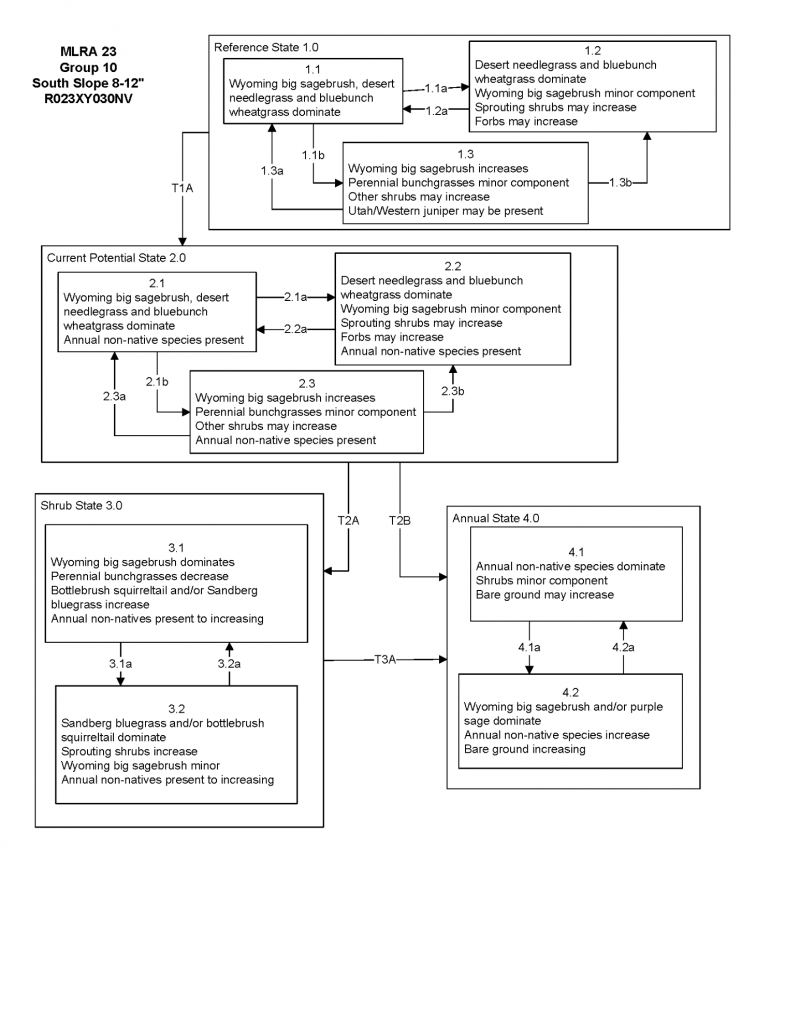

More interactive model formats are also available.
View Interactive Models
Click on state and transition labels to scroll to the respective text
State 1 submodel, plant communities
State 2 submodel, plant communities
State 3 submodel, plant communities
State 4 submodel, plant communities
State 1
Reference State
Community 1.1
Community Phase
The reference plant community is dominated by Wyoming big sagebrush, desert needlegrass and bluebunch wheatgrass. Potential vegetative composition is about 55% grasses, 5% forbs and 40% shrubs. Approximate ground cover (basal and crown) is about 15 to 25 percent.
Figure 5. Annual production by plant type (representative values) or group (midpoint values)
Table 5. Annual production by plant type
| Plant type | Low (lb/acre) |
Representative value (lb/acre) |
High (lb/acre) |
|---|---|---|---|
| Grass/Grasslike | 83 | 165 | 275 |
| Shrub/Vine | 57 | 114 | 190 |
| Forb | 7 | 15 | 25 |
| Tree | 3 | 6 | 10 |
| Total | 150 | 300 | 500 |
Community 1.2
Community Phase
Community 1.3
Community Phase
Pathway a
Community 1.1 to 1.2
Pathway b
Community 1.1 to 1.3
Pathway a
Community 1.2 to 1.1
Pathway a
Community 1.3 to 1.1
Pathway b
Community 1.3 to 1.2
State 2
Current Potential
Community 2.1
Community Phase
Community 2.2
Community Phase
Community 2.3
Community Phase
Pathway a
Community 2.1 to 2.2
Pathway b
Community 2.1 to 2.3
Pathway a
Community 2.2 to 2.1
Pathway b
Community 2.3 to 2.2
State 3
Shrub State
Community 3.1
Community Phase (at risk)
Community 3.2
Community Phase (at risk)
Pathway a
Community 3.1 to 3.2
Pathway a
Community 3.2 to 3.1
State 4
Annual State
Community 4.1
Community Phase (at risk)
State 5
Tree State
Possible tree state - needs verification in the field
State 6
Seeded State
Possible seeded state - needs more verification in the field
Transition A
State 1 to 2
Transition A
State 2 to 3
Transition B
State 2 to 4
Transition A
State 3 to 4
Additional community tables
Table 6. Community 1.1 plant community composition
| Group | Common name | Symbol | Scientific name | Annual production (lb/acre) | Foliar cover (%) | |
|---|---|---|---|---|---|---|
|
Grass/Grasslike
|
||||||
| 1 | Primary Perennial Grasses | 87–228 | ||||
| desert needlegrass | ACSP12 | Achnatherum speciosum | 45–90 | – | ||
| bluebunch wheatgrass | PSSPS | Pseudoroegneria spicata ssp. spicata | 30–90 | – | ||
| Thurber's needlegrass | ACTH7 | Achnatherum thurberianum | 6–24 | – | ||
| Indian ricegrass | ACHY | Achnatherum hymenoides | 6–24 | – | ||
| 2 | Secondary Perennial Grasses | 6–24 | ||||
| squirreltail | ELEL5 | Elymus elymoides | 2–9 | – | ||
| basin wildrye | LECI4 | Leymus cinereus | 2–9 | – | ||
| Sandberg bluegrass | POSE | Poa secunda | 2–9 | – | ||
|
Forb
|
||||||
| 3 | Perennial | 6–24 | ||||
| milkvetch | ASTRA | Astragalus | 2–6 | – | ||
| buckwheat | ERIOG | Eriogonum | 2–6 | – | ||
| princesplume | STANL | Stanleya | 2–6 | – | ||
|
Shrub/Vine
|
||||||
| 4 | Primary Shrubs | 81–165 | ||||
| Wyoming big sagebrush | ARTRW8 | Artemisia tridentata ssp. wyomingensis | 60–90 | – | ||
| purple sage | SADOI | Salvia dorrii ssp. dorrii var. incana | 15–45 | – | ||
| jointfir | EPHED | Ephedra | 6–30 | – | ||
| 5 | Secondary Shrubs | 30–45 | ||||
| shadscale saltbush | ATCO | Atriplex confertifolia | 3–15 | – | ||
| buckwheat | ERIOG | Eriogonum | 3–15 | – | ||
| spiny hopsage | GRSP | Grayia spinosa | 3–15 | – | ||
| desert peach | PRAN2 | Prunus andersonii | 3–15 | – | ||
| antelope bitterbrush | PUTR2 | Purshia tridentata | 3–15 | – | ||
| horsebrush | TETRA3 | Tetradymia | 3–15 | – | ||
|
Tree
|
||||||
| 6 | Evergreen | 2–6 | ||||
| Utah juniper | JUOS | Juniperus osteosperma | 2–6 | – | ||
Interpretations
Animal community
Livestock Interpretations:
This site has limited value for livestock grazing, due to the low forage production and steep slopes. Young desert needlegrass is palatable to all classes of livestock. Mature herbage is moderately grazed by horses and cattle, but rarely grazed by sheep. Bluebunch wheatgrass is considered one of the most important forage grass species on western rangelands for livestock. Although bluebunch wheatgrass can be a crucial source of forage, it is not necessarily the most highly preferred species. Indian ricegrass is highly palatable to all classes of livestock in both green and cured condition. It supplies a source of green feed before most other native grasses have produced much new growth. Thurber’s needlegrass species begin growth early in the year and remain green throughout a relatively long growing season. This pattern of development enables animals to use Thurber’s needlegrass when many other grasses are unavailable. Cattle prefer Thurber’s needlegrass in early spring before fruits have developed as it becomes less palatable when mature. Thurber’s needlegrasses are grazed in the fall only if the fruits are softened by rain. Livestock browse Wyoming big sagebrush, but may use it only lightly when palatable herbaceous species are available. Purple sage has low to medium palatability for livestock. Ephedra is heavily browsed by livestock on winter range but only moderately or lightly browsed during other seasons.
Stocking rates vary over time depending upon season of use, climate variations, site, and previous and current management goals. A safe starting stocking rate is an estimated stocking rate that is fine tuned by the client by adaptive management through the year and from year to year.
Wildlife Interpretations:
Wyoming big sagebrush is preferred browse for wild ungulates. Pronghorn usually browse Wyoming big sagebrush heavily. Sagebrush-grassland communities provide critical sage-grouse breeding and nesting habitats. Meadows surrounded by sagebrush may be used as feeding and strutting grounds. Sagebrush is a crucial component of their diet year-round, and sage-grouse select sagebrush almost exclusively for cover. Sage-grouse prefer mountain big sagebrush and Wyoming big sagebrush communities to basin big sagebrush communities. Purple sage has low to medium palatability for wildlife. Ephedra is an important browse species for big game animals. Ephedra is heavily used by wildlife on winter ranges. Young desert needlegrass is palatable to many species of wildlife. Desert needlegrass produces considerable basal foliage and is good forage while young. Desert bighorn sheep graze desert needlegrass. Bluebunch wheatgrass is considered one of the most important forage grass species on western rangelands for wildlife. Bluebunch wheatgrass does not generally provide sufficient cover for ungulates, however, mule deer are frequently found in bluebunch-dominated grasslands. Indian ricegrass is eaten by pronghorn in moderate amounts whenever available. A number of heteromyid rodents inhabiting desert rangelands show preference for seed of Indian ricegrass. Indian ricegrass is an important component of jackrabbit diets in spring and summer. Indian ricegrass seed provides food for many species of birds. Doves, for example, eat large amounts of shattered Indian ricegrass seed lying on the ground. Thurber needlegrass is valuable forage for wildlife.
Hydrological functions
Runoff is high to very high. Permeability is very slow to moderately rapid. Hydrologic soil group is C and D.
Recreational uses
Aesthetic value is derived from the diverse floral and faunal composition and the colorful flowering of wild flowers and shrubs during the spring and early summer. This site offers rewarding opportunities to photographers and for nature study. This site is used for hiking and has potential for upland and big game hunting.
Other products
Native Americans made tea from big sagebrush leaves. They used the tea as a tonic, an antiseptic, for treating colds, diarrhea, and sore eyes and as a rinse to ward off ticks. Big sagebrush seeds were eaten raw or made into meal. Indian ricegrass was traditionally eaten by some Native Americans. The Paiutes used the seed as a reserve food source.
Other information
Wyoming big sagebrush is used for stabilizing slopes and gullies and for restoring degraded wildlife habitat, rangelands, mine spoils and other disturbed sites. It is particularly recommended on dry upland sites where other shrubs are difficult to establish. Ephedra is listed as a successful shrub for restoring western rangeland communities and can be used to rehabilitate disturbed lands. It also has value for reducing soil erosion on both clay and sandy soils. Ephedra establishes readily through direct seeding, transplants, and stem cuttings.
Supporting information
Type locality
| Location 1: Washoe County, NV | |
|---|---|
| Township/Range/Section | T29N R19E S6 |
| UTM zone | N |
| UTM northing | 254552 |
| UTM easting | 4477661 |
| Latitude | 40° 24′ 48″ |
| Longitude | 119° 53′ 34″ |
| General legal description | NE 1/4 SE 1/4, Willow Canyon area, west side of Smoke Creek Desert, Washoe County, Nevada. This site also occurs in Humboldt County, Nevada. |
Other references
Fire Effects Information System (Online; http://www.fs.fed.us/database/feis/plants/).
USDA-NRCS Plants Database (Online; http://www.plants.usda.gov).
Great Basin Ecological Site Development Project: State and Transition Models for Major Land Resource Area 23, Nevada and portions of California (Online; https://naes.agnt.unr.edu/PMS/Pubs/2019-4060.pdf)
Contributors
BH/SW
T Stringham (UNR under contract with BLM)
Approval
Kendra Moseley, 4/10/2025
Rangeland health reference sheet
Interpreting Indicators of Rangeland Health is a qualitative assessment protocol used to determine ecosystem condition based on benchmark characteristics described in the Reference Sheet. A suite of 17 (or more) indicators are typically considered in an assessment. The ecological site(s) representative of an assessment location must be known prior to applying the protocol and must be verified based on soils and climate. Current plant community cannot be used to identify the ecological site.
| Author(s)/participant(s) | P Novak-Echenique |
|---|---|
| Contact for lead author | State Rangeland Management Specialist |
| Date | 08/19/2010 |
| Approved by | Kendra Moseley |
| Approval date | |
| Composition (Indicators 10 and 12) based on | Annual Production |
Indicators
-
Number and extent of rills:
A few rills may be expected on steeper slopes in areas subjected to summer convection storms or rapid spring snowmelt. -
Presence of water flow patterns:
Water flow patterns are short (<5’ ) between shrubs and grasses. Some flow patterns may be connected to form small rills. -
Number and height of erosional pedestals or terracettes:
Pedestals are typically non-existent. Frost heaving of shallow rooted plants should not be considered a "normal" condition. -
Bare ground from Ecological Site Description or other studies (rock, litter, lichen, moss, plant canopy are not bare ground):
Bare Ground ± 15-30%; surface rock fragments less than 50%; foliar cover of perennial herbaceous plants 15 to 25 %. -
Number of gullies and erosion associated with gullies:
Gullies are non-existent in areas of this site that occur on stable landforms. -
Extent of wind scoured, blowouts and/or depositional areas:
None -
Amount of litter movement (describe size and distance expected to travel):
Fine litter (foliage from grasses and annual & perennial forbs) expected to move distance of slope length during intense summer convection storms or rapid snowmelt events. Persistent litter (large woody material) will remain in place except during catastrophic events. -
Soil surface (top few mm) resistance to erosion (stability values are averages - most sites will show a range of values):
Soil stability values should be 3 to 6 on most soil textures found on this site. (To be field tested.) -
Soil surface structure and SOM content (include type of structure and A-horizon color and thickness):
Surface structure is weak subangular blocky, massive, or weak medium platy. Soil surface colors are light brownish gray and soils are typified by an ochric epipedon. Organic matter content- 1 to 3 percent under shrub canopy. -
Effect of community phase composition (relative proportion of different functional groups) and spatial distribution on infiltration and runoff:
Perennial herbaceous plants (especially deep-rooted bunchgrasses [i.e., bluebunch wheatgrass] slow runoff and increase infiltration. Shrub canopy and associated litter break raindrop impact and provide opportunity for snow catch and accumulation on site. -
Presence and thickness of compaction layer (usually none; describe soil profile features which may be mistaken for compaction on this site):
Compacted layers are not typical. Subsoil argillic horizons shallow to the surface are not to be interpreted as compacted layers. -
Functional/Structural Groups (list in order of descending dominance by above-ground annual-production or live foliar cover using symbols: >>, >, = to indicate much greater than, greater than, and equal to):
Dominant:
Deep-rooted, cool season, perennial bunchgrassesSub-dominant:
tall shrubs (Wyoming big sagebrush) > associated shrubs>>deep-rooted, cool season, perennial forbs > fibrous, shallow-rooted, cool season, perennial and annual forbs = shallow-rooted, cool season, perennial grasses (Sandberg’s bluegrass); Shrub State: will have tall shrubs dominant>associated shrubs>>deep-rooted, cool-season perennial bunchgrassesOther:
Additional:
-
Amount of plant mortality and decadence (include which functional groups are expected to show mortality or decadence):
Dead branches within individual shrubs common and standing dead shrub canopy material may be as much as 25% of total woody canopy; some of the mature bunchgrasses (<10%) have dead centers. -
Average percent litter cover (%) and depth ( in):
Between plant interspaces (± 25%) and litter depth is ± ½ inch. -
Expected annual annual-production (this is TOTAL above-ground annual-production, not just forage annual-production):
For normal or average growing season (through June) ± 300 lbs/ac; Spring moisture significantly affects total production -
Potential invasive (including noxious) species (native and non-native). List species which BOTH characterize degraded states and have the potential to become a dominant or co-dominant species on the ecological site if their future establishment and growth is not actively controlled by management interventions. Species that become dominant for only one to several years (e.g., short-term response to drought or wildfire) are not invasive plants. Note that unlike other indicators, we are describing what is NOT expected in the reference state for the ecological site:
Invaders on this site include cheatgrass; rabbitbrush spp.; annual mustards, and knapweeds. Western juniper is an increaser on this site. -
Perennial plant reproductive capability:
All functional groups should reproduce in average (or normal) and above average growing season years
Print Options
Sections
Font
Other
The Ecosystem Dynamics Interpretive Tool is an information system framework developed by the USDA-ARS Jornada Experimental Range, USDA Natural Resources Conservation Service, and New Mexico State University.
Click on box and path labels to scroll to the respective text.