Natural Resources
Conservation Service
Ecological site R023XY089NV
WET MEADOW 10-14 P.Z.
Last updated: 4/10/2025
Accessed: 04/03/2026
General information
Provisional. A provisional ecological site description has undergone quality control and quality assurance review. It contains a working state and transition model and enough information to identify the ecological site.
MLRA notes
Major Land Resource Area (MLRA): 023X–Malheur High Plateau
Major Land Resource Area 23, known as the Malheur High Plateau, is 22,895 square miles (14.6 million acres) in size. Most of MLRA 23 is located in southeastern Oregon, with the remainder in northwestern Nevada and along the Nevada border in northeastern California. Elevation ranges from 3,900 – 6,900 feet in most of the area, but it exceeds 9,000 feet on some mountains. This MLRA consists of nearly level to moderately steep plateaus, basins, and valleys bordered by long, gently sloping alluvial vans. Occasional north-south fault-block mountain ranges separate the basins. Volcanic plateaus with basalt rock rims are common. Most of this are consists of young andesite and basalt layers. Basins between mountains are filled with alluvium, continental sediments, and volcanic ash. Playas or shallow seasonal
lakes are common in the lowest areas within the closed basins. The dominant soil orders in MLRA 23 are Aridisols and Mollisols. Soils primarily have a mesic or frigid temperature regime, and aridic or xericmoisture regime. Soils tend to be loamy or clayey.
The average annual precipitation is 6 – 12 inches, but can be as high as 57 inches in certain mountain ranges. This area experiences dry summers and receives most of its moisture throughout the fall, winter, and spring. Snow is common in winter. The average annual temperature is 39-52°F, decreasing with elevation. The freeze-free period averages 105 days, but ranges from 35 to 175 days along an elevation gradient.
Ecological site concept
This site occurs on flood plains in intermountain basins and receives supplemental water as run in. A water table is present throughout the growing season at a depth between 6 and 84 inches.
Site is very productive with 3000 lb/ac representative.
Associated sites
| R023XY009NV |
LOAMY BOTTOM 8-12 P.Z. Soil is loamy and water table is >60 inches. |
|---|
Similar sites
| R023XY002NV |
SALINE MEADOW DISP & PULE important grasses; SAVE4 commonly occurs; less productive site; soils saline-alkali affected |
|---|---|
| R023XY025NV |
WET MEADOW 14+ P.Z. DECE dominant grass; LETR5 absent to rare; higher elevations |
Table 1. Dominant plant species
| Tree |
Not specified |
|---|---|
| Shrub |
Not specified |
| Herbaceous |
(1) Poa nevadensis |
Physiographic features
This site occurs on inset fans adjacent to perennial streams and is often found localized around flowing springs and seeps. Slopes range from 0 to 4 percent, but slope gradients of 0 to 2 percent are most typical. Elevations are 4400 to 6200 feet.
Table 2. Representative physiographic features
| Landforms |
(1)
Inset fan
|
|---|---|
| Flooding duration | Long (7 to 30 days) |
| Flooding frequency | Rare to frequent |
| Elevation | 1,341 – 1,890 m |
| Slope | 0 – 4% |
| Water table depth | 15 – 213 cm |
| Aspect | Aspect is not a significant factor |
Climatic features
The climate associated with this site is semiarid and characterized by cool, moist winters and warm, dry summers. Average annual precipitation is 8 to 14 inches. Mean annual air temperature is 45 to 47 degrees F. The average growing season is about 80 to 100 days.
Nevada’s climate is predominantly arid, with large daily ranges of temperature, infrequent severe storms, heavy snowfall in the higher mountains, and great location variations with elevation. Three basic geographical factors largely influence Nevada’s climate: continentality, latitude, and elevation. Continentality is the most important factor. The strong continental effect is expressed in the form of both dryness and large temperature variations. Nevada lies on the eastern, lee side of the Sierra Nevada Range, a massive mountain barrier that markedly influences the climate of the State. The prevailing winds are from the west, and as the warm moist air from the Pacific Ocean ascend the western slopes of the Sierra Range, the air cools, condensation occurs and most of the moisture falls as precipitation. As the air descends the eastern slope, it is warmed by compression, and very little precipitation occurs. The effects of this mountain barrier are felt not only in the West but throughout the state, with the result that the lowlands of Nevada are largely desert or steppes. The temperature regime is also affected by the blocking of the inland-moving maritime air. Nevada sheltered from maritime winds, has a continental climate with well-developed seasons and the terrain responds quickly to changes in solar heating.
Nevada lies within the mid-latitude belt of prevailing westerly winds which occur most of the year. These winds bring frequent changes in weather during the late fall, winter and spring months, when most of the precipitation occurs. To the south of the mid-latitude westerlies, lies a zone of high pressure in subtropical latitudes, with a center over the Pacific Ocean. In the summer, this high-pressure belt shifts northward over the latitudes of Nevada, blocking storms from the ocean. The resulting weather is mostly clear and dry during the summer and early fall, with scattered thundershowers. The eastern portion of the state receives significant summer thunderstorms generated from monsoonal moisture pushed up from the Gulf of California, known as the North American monsoon. The monsoon system peaks in August and by October the monsoon high over the Western U.S. begins to weaken and the precipitation retreats southward towards the tropics (NOAA 2004).
Average annual precipitation is 16 to over 20 inches. Mean annual air temperature is 41 to 44 degrees F. The average growing season is about 50 to 70 days.
Mean annual precipitaion at the Bear Creek, Nevada SNOTEL station (170501020301) is 37.69 inches.
monthly mean precipitation is:
January 3.84; February 3.75; March 4.38; April 4.9;
May 3.99; June 2.82; July .95; August 1.66;
September 1.22; October 2.12;
November 3.67; December 4.38.
Table 3. Representative climatic features
| Frost-free period (characteristic range) | 80 days |
|---|---|
| Freeze-free period (characteristic range) | 114 days |
| Precipitation total (characteristic range) | 406-457 mm |
| Frost-free period (actual range) | 80 days |
| Freeze-free period (actual range) | 114 days |
| Precipitation total (actual range) | 406-457 mm |
| Frost-free period (average) | 80 days |
| Freeze-free period (average) | 114 days |
| Precipitation total (average) | 432 mm |
Figure 1. Monthly precipitation range
Figure 2. Monthly minimum temperature range
Figure 3. Monthly maximum temperature range
Figure 4. Monthly average minimum and maximum temperature
Figure 5. Annual precipitation pattern
Figure 6. Annual average temperature pattern
Climate stations used
-
(1) FT BIDWELL [USC00043157], Cedarville, CA
-
(2) DENIO 52 WSW [USW00004139], Gerlach, NV
Influencing water features
This site occurs adjacent to perennial streams and is often found localized around flowing springs and seeps.
Soil features
The soils associated with this site are very deep and very poorly drained. The soils are formed in alluvium derived from pyroclastic volcanic rocks. There are high amounts of vitric volcanic ash and glass throughout the soil profile which enhances the water holding capacity. The available water capacity is high. Endosaturation is present with an apparent seasonal high water table between the soil surface and 46 cm between January and May. These soils are susceptible to occasional flooding for brief periods or frequent flooding for long periods mainly between January and May. A thick mollic epipedon occurs from the soil surface to 104 cm. The soil series associated with this site include: Wetvit, a ashy, glassy, mesic, Aquandic Endoaquolls.
Table 4. Representative soil features
| Parent material |
(1)
Alluvium
–
pyroclastic rock
|
|---|---|
| Surface texture |
(1) Ashy loam (2) Loam |
| Family particle size |
(1) Clayey |
| Drainage class | Poorly drained |
| Permeability class | Moderately slow |
| Soil depth | 183 – 213 cm |
| Surface fragment cover <=3" | 0% |
| Surface fragment cover >3" | 0% |
| Available water capacity (0-101.6cm) |
19.05 – 21.08 cm |
| Calcium carbonate equivalent (0-101.6cm) |
0% |
| Electrical conductivity (0-101.6cm) |
0 mmhos/cm |
| Sodium adsorption ratio (0-101.6cm) |
0 |
| Soil reaction (1:1 water) (0-101.6cm) |
6.1 – 7.8 |
| Subsurface fragment volume <=3" (Depth not specified) |
3 – 9% |
| Subsurface fragment volume >3" (Depth not specified) |
0% |
Ecological dynamics
Where management results in abusive grazing by livestock and/or feral horses, coarse-fibered grass-like plants and forbs become dominant on this site as Nevada bluegrass and other desirable forage grasses and forbs. Creeping wildrye is prevalent on the wetter areas within the site. This plant community is susceptible to gully erosion, which can result in a lowering of the water table reducing site productivity and changing the species composition toward more drought tolerant plants. Thistles and woody vegetation are plants likely to invade this site.
Fire Ecology:
Fire in wet meadow communities often only top-kills plants. Prescribed fires are most effective in late summer, early fall, or during dry years when the water is below the soil surface. The sedges have deep buried rhizomes which usually survive all but the most severe fires. Nevada bluegrass is generally unharmed by fire. It produces little litter, and its small bunch size and sparse litter reduces the amount of heat transferred to perennating buds in the soil. Creeping wildrye is top-killed by fire. Creeping wildrye is generally tolerant of fire but may be damaged by early season fire combined with dry soil conditions. Sedge is top-killed by fire, with rhizomes protected by insulating soil. The rhizomes of sedge species may be killed by high-severity fires that remove most of the soil organic layer. Reestablishment after fire occurs by seed establishment and/or rhizomatous spread. Meadow barley has high fire tolerance. Meadow barley grows in moist habitats that experience infrequent fire. Baltic rush is fire tolerant when dormant and top-killed by fire during the growing season. It establishes after fire through seed and/or lateral spread by rhizomes. Basin wildrye is top-killed by fire. Older basin wildrye plants with large proportions of dead material within the perennial crown can be expected to show higher mortality due to fire than younger plants having little debris. Basin wildrye is generally tolerant of fire but may be damaged by early season fire combined with dry soil conditions.
State and transition model
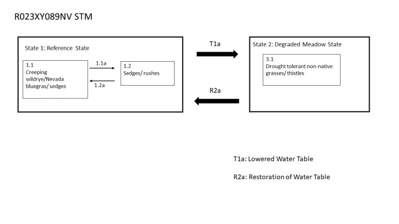
Figure 7. R023XY089NV State and Transition Model
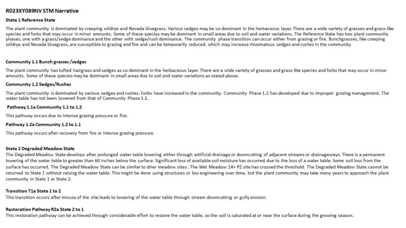
Figure 8. R023XY089NV STM Narrative
More interactive model formats are also available.
View Interactive Models
More interactive model formats are also available.
View Interactive Models
Click on state and transition labels to scroll to the respective text
Ecosystem states
State 1 submodel, plant communities
State 1
Reference Plant Community
Community 1.1
Reference Plant Community
The reference plant community is dominated by Nevada bluegrass, creeping wildrye, and grass-like plants. Potential vegetative composition is about 84% grasses, 15% forbs, and 1% shrubs. Approximate ground cover (basal) is about 75 to 85 percent.
Figure 9. Annual production by plant type (representative values) or group (midpoint values)
Table 5. Annual production by plant type
| Plant type | Low (kg/hectare) |
Representative value (kg/hectare) |
High (kg/hectare) |
|---|---|---|---|
| Grass/Grasslike | 1883 | 2825 | 3766 |
| Forb | 336 | 504 | 673 |
| Shrub/Vine | 22 | 34 | 45 |
| Total | 2241 | 3363 | 4484 |
Additional community tables
Table 6. Community 1.1 plant community composition
| Group | Common name | Symbol | Scientific name | Annual production (kg/hectare) | Foliar cover (%) | |
|---|---|---|---|---|---|---|
|
Grass/Grasslike
|
||||||
| 1 | Primary Perennial Grasses/Grasslikes | 2387–4506 | ||||
| beardless wildrye | LETR5 | Leymus triticoides | 504–1009 | – | ||
| sedge | CAREX | Carex | 336–673 | – | ||
| meadow barley | HOBR2 | Hordeum brachyantherum | 67–269 | – | ||
| basin wildrye | LECI4 | Leymus cinereus | 67–269 | – | ||
| 2 | Secondary Perennial Grasses/Grasslikes | 168–504 | ||||
| bentgrass | AGROS2 | Agrostis | 17–168 | – | ||
| sloughgrass | BECKM | Beckmannia | 17–168 | – | ||
| tufted hairgrass | DECE | Deschampsia cespitosa | 17–168 | – | ||
| spikerush | ELEOC | Eleocharis | 17–168 | – | ||
| foxtail barley | HOJU | Hordeum jubatum | 17–168 | – | ||
|
Forb
|
||||||
| 3 | Perennial | 336–673 | ||||
| common yarrow | ACMI2 | Achillea millefolium | 17–101 | – | ||
| Rocky Mountain iris | IRMI | Iris missouriensis | 17–101 | – | ||
| cinquefoil | POTEN | Potentilla | 17–101 | – | ||
| ragwort | SENEC | Senecio | 17–101 | – | ||
|
Shrub/Vine
|
||||||
| 4 | Primary Shrubs | 1–67 | ||||
| silver sagebrush | ARCA13 | Artemisia cana | 17–34 | – | ||
| big sagebrush | ARTR2 | Artemisia tridentata | 17–34 | – | ||
| gooseberry currant | RIMO2 | Ribes montigenum | 17–34 | – | ||
| rose | ROSA5 | Rosa | 17–34 | – | ||
| willow | SALIX | Salix | 17–34 | – | ||
Interpretations
Animal community
Livestock Interpretations:
This site is suitable for livestock grazing. Grazing management should be keyed to perennial grass production. Nevada bluegrass is a widespread forage grass. It is one of the earliest grasses in the spring and is sought by domestic livestock and several wildlife species. Nevada bluegrass is a palatable species, but its production is closely tied to weather conditions. It produces little forage in drought years, making it a less dependable food source than other perennial bunchgrasses. Creeping wildrye can be used for forage and is very palatable to all livestock. Once established it is very rhizomatous and maintains stands for many years. Sedge provides good to fair forage for domestic grazing. Meadow barley tends to increase and replace the more palatable plants in moist meadows and in other sites favorable to growth, especially if such areas are somewhat overgrazed. Baltic rush is described as a fair to good forage species for cattle. On average, Baltic rush’s palatability is considered medium to moderately low. Baltic rush is considered palatable early in the growing season when plants are young and tender, but as stems mature and toughen palatability declines. The early growth and abundant production of basin wildrye make it a valuable source of forage for livestock. It is important forage for cattle and is readily grazed by cattle and horses in early spring and fall. Though coarse-textured during the winter, basin wildrye may be utilized more frequently by livestock and wildlife when snow has covered low shrubs and other grasses.
Stocking rates vary over time depending upon season of use, climate variations, site, and previous and current management goals. A safe starting stocking rate is an estimated stocking rate that is fine tuned by the client by adaptive management through the year and from year to year.
Wildlife Interpretations:
Nevada bluegrass is desirable for pronghorn antelope and mule deer in the spring and preferable in the spring, summer, and fall for elk and desirable as part of their winter range. Creeping wildrye is used for forage for many wildlife species and is often used for cover. Sedges have a high to moderate resource value for elk and a medium value for mule deer. Elk consume beaked sedge later in the growing season. Meadow barley is an important forage species for many wildlife species. Baltic rush provides food for several wildlife species and waterfowl. Baltic rush is an important cover species for a variety of small birds, upland game birds, birds of prey, and waterfowl. Basin wildrye provides winter forage for mule deer, though use is often low compared to other native grasses. Basin wildrye provides summer forage for black-tailed jackrabbits. Because basin wildrye remains green throughout early summer, it remains available for small mammal forage for longer time than other grasses.
Hydrological functions
Runoff is very high. Permeability is moderately slow. Hydrologic soil group is C and D.
Recreational uses
Aesthetic value is derived from the diverse floral and faunal composition and the colorful flowering of wild flowers and shrubs during the spring and early summer. This site offers rewarding opportunities to photographers and for nature study. This site is used for camping and hiking and has potential for upland and big game hunting.
Other products
The stems of Baltic rush were historically used by Native Americans as a foundation for coiled basketry. Basin wildrye was used as bedding for various Native American ceremonies, providing a cool place for dancers to stand.
Other information
Creeping wildrye is primarily used for reclamation of wet, saline soils. Baltic rush's production of deep and fibrous roots originating from a mass of coarse and creeping rhizomes makes it a valuable species for stabilizing streambanks and protecting against soil erosion. Basin wildrye is useful in mine reclamation, fire rehabilitation and stabilizing disturbed areas. Its usefulness in range seeding, however, may be limited by initially weak stand establishment.
Supporting information
Inventory data references
NRCS-ECS-5
3 NV-ECS-1
NRCS-RANGE-417
NV-4400-13 (BLM)
Type locality
| Location 1: Washoe County, NV | |
|---|---|
| Township/Range/Section | T42N R19E S34 |
| UTM zone | N |
| UTM northing | 262963 |
| UTM easting | 4600112 |
| Latitude | 41° 31′ 3″ |
| Longitude | 119° 50′ 26″ |
| General legal description | NW 1/4, About 5½ miles south of Vya, on east side of County Road 34, Long Valley area, Washoe County, Nevada. This site also occurs in Humboldt County, Nevada. |
Other references
Fire Effects Information System (Online; http://www.fs.fed.us/database/feis/plants/).
USDA-NRCS Plants Database (Online; http://www.plants.usda.gov).
Central Nevada Riparian Field Guide, Weixelman et al USFS 1996.
Contributors
GKB
DMP
Rangeland health reference sheet
Interpreting Indicators of Rangeland Health is a qualitative assessment protocol used to determine ecosystem condition based on benchmark characteristics described in the Reference Sheet. A suite of 17 (or more) indicators are typically considered in an assessment. The ecological site(s) representative of an assessment location must be known prior to applying the protocol and must be verified based on soils and climate. Current plant community cannot be used to identify the ecological site.
| Author(s)/participant(s) | PNOVAK-ECHENIQUE |
|---|---|
| Contact for lead author | State Rangeland Management Specialist |
| Date | 05/06/2013 |
| Approved by | Kendra Moseley |
| Approval date | |
| Composition (Indicators 10 and 12) based on | Annual Production |
Indicators
-
Number and extent of rills:
Rills are none. -
Presence of water flow patterns:
Water flow patterns are none. -
Number and height of erosional pedestals or terracettes:
Pedestals are none. -
Bare ground from Ecological Site Description or other studies (rock, litter, lichen, moss, plant canopy are not bare ground):
Bare Ground ± 5-15%. -
Number of gullies and erosion associated with gullies:
None -
Extent of wind scoured, blowouts and/or depositional areas:
None -
Amount of litter movement (describe size and distance expected to travel):
Fine litter (foliage of grasses and annual & perennial forbs) only expected to move during periods of flooding by adjacent streams. Persistent litter (large woody material) will remain in place except during flooding events. -
Soil surface (top few mm) resistance to erosion (stability values are averages - most sites will show a range of values):
Soil stability values will range from 4 to 6. (To be field tested.) -
Soil surface structure and SOM content (include type of structure and A-horizon color and thickness):
Soil surface structure is subangular blocky, medium platy, or granular. Soil surface colors are dark browns and the soils have thick mollic epipedons. Organic matter can range from 2 to 4 percent for much of the upper 20 inches. -
Effect of community phase composition (relative proportion of different functional groups) and spatial distribution on infiltration and runoff:
Deep-rooted perennial grasses and/or rhizomatous grass-likes (i.e. rush) slow runoff and increase infiltration. -
Presence and thickness of compaction layer (usually none; describe soil profile features which may be mistaken for compaction on this site):
Compacted layers are none. Prismatic structure or massive subsurface layers are not to be interpreted as compaction. -
Functional/Structural Groups (list in order of descending dominance by above-ground annual-production or live foliar cover using symbols: >>, >, = to indicate much greater than, greater than, and equal to):
Dominant:
Deep-rooted, cool season, perennial grasses and grass-like plants > rhizomatous grassesSub-dominant:
deep-rooted, cool season, perennial forbs = fibrous, shallow-rooted, cool season, annual and perennial forbs > tall shrubs.Other:
Additional:
-
Amount of plant mortality and decadence (include which functional groups are expected to show mortality or decadence):
Little to no decadence present -
Average percent litter cover (%) and depth ( in):
Under canopy and between plant interspaces up to 80% and litter depth is > ¼ inch. -
Expected annual annual-production (this is TOTAL above-ground annual-production, not just forage annual-production):
For normal or average growing season (through June) ± 3000 lbs/ac. Favorable years ± 4000 lbs/ac, unfavorable years ± 2000 lbs/ac -
Potential invasive (including noxious) species (native and non-native). List species which BOTH characterize degraded states and have the potential to become a dominant or co-dominant species on the ecological site if their future establishment and growth is not actively controlled by management interventions. Species that become dominant for only one to several years (e.g., short-term response to drought or wildfire) are not invasive plants. Note that unlike other indicators, we are describing what is NOT expected in the reference state for the ecological site:
Potential invaders include rubber rabbitbrush, thistles, knapweeds, tall whitetop (perennial pepperweed), and salt cedar. -
Perennial plant reproductive capability:
All functional groups should reproduce in most years.
Print Options
Sections
Font
Other
The Ecosystem Dynamics Interpretive Tool is an information system framework developed by the USDA-ARS Jornada Experimental Range, USDA Natural Resources Conservation Service, and New Mexico State University.
Click on box and path labels to scroll to the respective text.