Natural Resources
Conservation Service
Ecological site R023XY104OR
LOAMY BOTTOM
Last updated: 4/10/2025
Accessed: 04/02/2026
General information
Provisional. A provisional ecological site description has undergone quality control and quality assurance review. It contains a working state and transition model and enough information to identify the ecological site.
Ecological site concept
This site typically occurs on low terraces associated with intermittent or perennial drainage systems or on low terraces on large lake basins. Elevations range from 4000 to 5500 feet and slopes range from 0 to 7 percent. The soils associated with this site are deep to moderately deep. Available moisture for plant growth is augmented by run-on water and a seasonal water table. The soil climate is frigid (soil temperature regime) and xeric (soil moisture regime). The reference plant community is characterized by basin big sagebrush in the overstory and basin wildrye dominating the understory, Nevada bluegrass and creeping wildrye are also common in the understory.
Associated sites
| R023XY115OR |
WET MARSH |
|---|---|
| R023XY117OR |
BASIN WET MEADOW |
| R023XY118OR |
BASIN DRY MEADOW |
| R023XY414OR |
SEMI WET MEADOW |
Similar sites
| R023XY009NV |
LOAMY BOTTOM 8-12 P.Z. |
|---|
Table 1. Dominant plant species
| Tree |
Not specified |
|---|---|
| Shrub |
(1) Artemisia tridentata ssp. tridentata |
| Herbaceous |
(1) Leymus cinereus |
Physiographic features
This site typically occurs on low terraces associated with intermittent or perennial drainage systems or on low terraces on large lake basins. Slopes range from 0 to 7 percent. Elevations range from 4000 to 5500 feet.
Table 2. Representative physiographic features
| Landforms |
(1)
Terrace--stream or lake
|
|---|---|
| Flooding frequency | None |
| Ponding duration | Very brief (4 to 48 hours) to brief (2 to 7 days) |
| Ponding frequency | None to rare |
| Elevation | 4,000 – 5,500 ft |
| Slope | 7% |
| Water table depth | 30 – 60 in |
| Aspect | Aspect is not a significant factor |
Climatic features
The annual precipitation ranges from 10 to 16 inches, most of which occurs in the form of snow during December through February. This moisture is augmented by run-on water and a seasonal water table allowing the site to occur across a large climatic gradient. The soil temperature regime is frigid. Extreme temperatures range from 110 degrees F to -30 degrees F. The frost-free period is from 50 to 90 days. The optimum period for plant growth is early April through July.
Precipitation is augmented by run-on water and seasonal water table.
Table 3. Representative climatic features
| Frost-free period (characteristic range) | 52-67 days |
|---|---|
| Freeze-free period (characteristic range) | 110-113 days |
| Precipitation total (characteristic range) | 10-16 in |
| Frost-free period (average) | 59 days |
| Freeze-free period (average) | 112 days |
| Precipitation total (average) | 12 in |
Figure 1. Monthly precipitation range
Figure 2. Monthly minimum temperature range
Figure 3. Monthly maximum temperature range
Figure 4. Monthly average minimum and maximum temperature
Figure 5. Annual precipitation pattern
Figure 6. Annual average temperature pattern
Climate stations used
-
(1) O O RCH [USC00356302], Riley, OR
-
(2) MALHEUR REFUGE HQ [USC00355162], Burns, OR
-
(3) P-RANCH SOUTH PLACE [USC00356853], Princeton, OR
Influencing water features
This site is influenced by run-on water from adjacent sites and a seasonal water table between 30 and 60 inches.
Soil features
The soils of this site are deep to moderately deep, moderately well-drained to well-drained, and medium to fine-textured. Soils are derived from alluvium or lacustrine deposits. The surface layer is typically a silt loam. The subsoil and substratum is typically silt loam or loam. Permeability is moderate to moderately slow. The available water holding capacity (AWC) is 10 to 15 inches for the profile. Depth to water table is usually greater than 60 inches, but may be in the root zone during part of the growing season.
Representative soil series for this site is Widowspring.
Table 4. Representative soil features
| Parent material |
(1)
Alluvium
(2) Lacustrine deposits |
|---|---|
| Surface texture |
(1) Silt loam |
| Family particle size |
(1) Fine-silty (2) Fine-loamy |
| Drainage class | Moderately well drained to well drained |
| Permeability class | Moderate to moderately slow |
| Soil depth | 40 – 100 in |
| Surface fragment cover <=3" | 5% |
| Surface fragment cover >3" | 2% |
| Available water capacity (0-40in) |
8 – 9 in |
| Soil reaction (1:1 water) (0-40in) |
6.5 – 8 |
| Subsurface fragment volume <=3" (0-40in) |
10% |
| Subsurface fragment volume >3" (0-40in) |
2% |
Ecological dynamics
The reference plant community is dominated by basin wildrye with basin big sagebrush in the overstory. Creeping wildrye and Nevada bluegrass are also common. The site occurs on low terraces associated with intermittent or perennial drainage systems or on low terraces on large lake basins. Available moisture for plant growth is augmented by run-on water and a seasonal water table allowing the site to occur across a large climatic gradient.
The site has moderate resilience to disturbance and resistance to invasion (Stringham et al. 2015). Resilience is a system’s capacity to regain its structure, processes, and function following stressors or disturbance (e.g. drought or fire). Resistance is the capacity of the system to retain its structure, processes, and function despite stressors or disturbances (including pressure from invasive species) (Chambers 2014). Increased resilience increases with elevation, aspect, increased precipitation and increased nutrient availability (Stringham et al. 2015); where greater resource availability and more favorable environmental conditions exist for plant growth and reproduction (Chambers 2014). High available soil moisture allows this site to be highly productive. This added productivity results in fewer open spaces where invasive annual grasses and undesirable forbs can become established.
A primary disturbances on this ecological site are drought, fire, flooding, Aroga infestation (Aroga websteri), and channel incision or other disturbance leading to a lowered seasonal water table. This facilitates an increase in shrubs and a decrease in basin wildrye. Troublesome non-native weeds such as broadleaved pepperweed (or tall whitetop, Lepidium latifolium), hoary cress (or whitetop, Cardaria draba), scotch cottonthistle (Onopordum acanthium), or bull thistle (Cirsium vulgare) are potential invaders on this site.
Basin wildrye is a large, cool-season, perennial bunchgrass with an extensive deep, coarse fibrous, weakly rhizomatous, root system (Reynolds and Fraley 1989, Zschaechner 1985). Clumps may reach up to six feet in height (Ogle et al. 2012). Basin wildrye does not tolerate long periods of inundation; it prefers cycles of wet winters and dry summers and is most commonly found in deep soils with high water holding capacities or seasonally high water tables (Ogle et al. 2012, Perryman and Skinner 2007).
Although no longer considered a different species than Sandberg’s bluegrass, ecologically speaking Nevada bluegrass occupies a different ecological niche and is not as grazing tolerant as Sandberg bluegrass. The species occurs throughout an unusually wide elevational range from a few hundred feet above sea level to near 11,000 feet in Colorado. It is often found along partially shaded stream banks and creek bottoms, irrigated fields and meadows and where moisture is plentiful has produced a good enough stand to be hayed (USDA 1988).
Hydrology:
The typical seasonally high water table occurs at depths within 60 inches of the surface which allows for significant production of basin wildrye. Seasonally high water tables have been found necessary for maintenance of site productivity and reestablishment of basin wildrye stands following disturbances such as fire, drought or excessive herbivory (Eckert et al. 1973). The sensitivity of basin wildrye seedling establishment to reduced soil water availability is increased as soil pH increases (Stuart et al. 1971). Lowering of the water table through extended drought, channel incision or water pumping will decrease basin wildrye production and establishment while sagebrush, black greasewood, rabbitbrush, and invasive weeds increase. Farming and abandonment may facilitate the creation of surface vesicular crust, increased surface ponding and decreased infiltration; which leads to dominance by sprouting shrubs with a weedy understory.
Fire Ecology:
Fire return intervals in basin big sagebrush are intermediate between mountain big sagebrush (15 to 25 years) and Wyoming big sagebrush (10 to 70 years). A naturally wide variation in fire frequency in this system is expected. Basin big sagebrush is readily killed when aboveground plant parts are charred by fire. Prolific seed production from nearby unburned plants coupled with high germination rates enables seedlings to establish rapidly following fire.
Basin wildrye is top-killed by fire. Older basin wildrye plants with large proportions of dead material within the perennial crown can be expected to show higher mortality due to fire than younger plants having little debris. Basin wildrye is generally tolerant of fire but may be damaged by early season fire combined with dry soil conditions. Nevada bluegrass is generally unharmed by fire. It produces little litter, and its small bunch size and sparse litter reduces the amount of heat transferred to perennating buds in the soil.
Adapted from: Stringham, T.K., D. Snyder, P. Novak-Echenique, A. Wartgow, A. Badertscher, K. O’Neill. 2019. Great Basin Ecological Site Development Project: State-and-Transition Models for Major Land Resource Area 23, Nevada and Portions of California. University of Nevada Reno, Nevada Agricultural Experiment Station Research Report 2019-01. 605 p.
State and transition model

More interactive model formats are also available.
View Interactive Models
Click on state and transition labels to scroll to the respective text
Ecosystem states
State 2 submodel, plant communities
State 3 submodel, plant communities
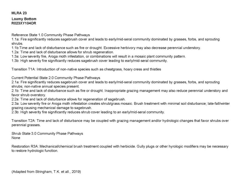
State 1
Reference State
The Reference State 1.0 represents the natural range of variability under pristine conditions. The reference state has three general community phases: a shrub-grass dominant phase, a perennial grass dominant phase, and a shrub dominant phase. State dynamics are maintained by interactions between climatic patterns and disturbance regimes. Negative feedbacks enhance ecosystem resilience and contribute to the stability of the state. These include the presence of all structural and functional groups, low fine fuel loads, and retention of organic matter and nutrients. Plant community phase changes are primarily driven by fire, periodic drought, and/or insect or disease attack.
Community 1.1
Basin wildrye, western wheatgrass, and basin big sagebrush dominate the plant community. Forbs and other grasses make up smaller components. *POSE is Nevada Bluegrass (PONE3)
Dominant plant species
-
basin big sagebrush (Artemisia tridentata ssp. tridentata), shrub
-
basin wildrye (Leymus cinereus), grass
Figure 7. Annual production by plant type (representative values) or group (midpoint values)
Table 5. Annual production by plant type
| Plant type | Low (lb/acre) |
Representative value (lb/acre) |
High (lb/acre) |
|---|---|---|---|
| Grass/Grasslike | 1625 | 3655 | 4875 |
| Shrub/Vine | 200 | 450 | 600 |
| Forb | 175 | 395 | 525 |
| Total | 2000 | 4500 | 6000 |
Community 1.2
This community phase is characteristic of a post-disturbance, early to mid-seral community phase. Basin wildrye, Nevada bluegrass, western wheatgrass, and other perennial bunchgrasses dominate. Depending on fire severity or intensity of Aroga moth infestation, patches of intact sagebrush may remain. Rabbitbrush may be sprouting.
Community 1.3
Big sagebrush and rabbitbrush increase in the absence of disturbance. Decadent sagebrush dominates the overstory and the deep-rooted perennial bunchgrasses in the understory are reduced either from competition with shrubs and/or from herbivory. Povertyweed and squirreltail increase.
Pathway 1.1a
Community 1.1 to 1.2
Fire would decrease or eliminate the overstory of sagebrush and allow the perennial bunchgrasses and rhizomatous grasses to dominate the site. Due to the productivity of this site, fires would typically eliminate or severely reduce the sagebrush component. A severe infestation of Aroga moth could also cause a large decrease in sagebrush giving a competitive advantage to the perennial grasses and forbs.
Pathway 1.1b
Community 1.1 to 1.3
Time and lack of disturbance such as fire allows sagebrush to increase and become decadent. Long-term drought, herbivory, or combinations of these would cause a decline in perennial bunchgrasses and fine fuels and lead to a reduced fire frequency allowing big sagebrush and/or rubber rabbitbrush to dominate the site.
Pathway 1.2a
Community 1.2 to 1.1
Time and lack of disturbance allows big sagebrush to reestablish and increase.
Pathway 1.3a
Community 1.3 to 1.1
A low severity fire, Aroga moth or combination would reduce the sagebrush overstory and create a sagebrush/grass mosaic with sagebrush and perennial bunchgrasses co-dominant.
Pathway 1.3b
Community 1.3 to 1.2
Fire would decrease or eliminate the overstory of sagebrush and allow the perennial bunchgrasses to dominate the site. Fires would typically be low severity resulting in a mosaic pattern due to low fine fuel loads. A fire following an unusually wet spring or a change in management favoring an increase in fine fuels, may be more severe and reduce sagebrush cover to trace amounts. A severe infestation of Aroga moth could also cause a large decrease in sagebrush within the community, giving a competitive advantage to the perennial grasses and forbs.
State 2
Current Potential
This state is similar to the Reference State 1.0 with the same three general community phases. Ecological function has not changed, however the resiliency of the state has been reduced by the presence of invasive weeds. Negative feedbacks enhance ecosystem resilience and contribute to the stability of the state. These include the presence of all structural and functional groups, fine fuel loads within the range of site variability and retention of organic matter and nutrients. Positive feedbacks decrease ecosystem resilience and stability of the state. These include the non-natives’ high seed output, persistent seed bank, rapid growth rate, ability to cross pollinate and adaptations for seed dispersal. Additionally, the presence of highly flammable, non-native species reduces State resilience because these species can promote fire where historically fire has been infrequent leading to positive feedbacks that further the degradation of the system.
Community 2.1
This community phase is similar to the Reference State Community Phase 1.1, with the presence of some non-native weedy species. Basin wildrye, Nevada bluegrass, western wheatgrass, and basin big sagebrush dominate the site. Non-native species are present in minor amounts.
Community 2.2
This community phase is characteristic of a post-disturbance, early seral community phase. Basin wildrye, Nevada bluegrass, western wheatgrass, and other perennial bunchgrasses dominate the site. Sagebrush is present in trace amounts. Depending on fire severity or intensity of Aroga moth infestations, patches of intact sagebrush may remain. Non-native species generally respond well after fire and may be stable or increasing within the community. Rabbitbrush may be sprouting and/or dominant in overstory. Seeded species may be present.
Community 2.3
(At Risk)
This community is at risk of crossing a threshold to another state. Sagebrush dominates the overstory and perennial bunchgrasses in the understory are reduced, either from competition with shrubs or from inappropriate grazing management, or from both. Rabbitbrush may be a significant component. Povertyweed and squirreltail increase. Non-native species may be stable or increasing due to lack of competition with perennial bunchgrasses. This site is susceptible to further degradation from inappropriate grazing management, drought, fire, and/or hydrologic change.
Pathway 2.1a
Community 2.1 to 2.2
Fire reduces the shrub overstory and allows perennial bunchgrasses to dominate the site. Fires typically remove the majority of the big sagebrush overstory due the large amount of fine fuel produced by this site. A severe infestation of Aroga moth could also cause a large decrease in sagebrush within the community, giving a competitive advantage to the perennial grasses and forbs. Non-native species are likely to increase after fire.
Pathway 2.1b
Community 2.1 to 2.3
Time, long-term drought, grazing management or a combination of these that favors shrubs would allow sagebrush and rabbitbrush to increase and dominate the site, causing a reduction in the perennial bunchgrasses.
Pathway 2.2a
Community 2.2 to 2.1
Time and lack of disturbance and/or grazing management that favors the establishment and growth of sagebrush allows the shrub component to recover. The establishment of big sagebrush may take many years.
Pathway 2.3a
Community 2.3 to 2.1
A low severity fire, Aroga moth infestation, brush management with minimal soil disturbance, or late fall/winter grazing would decrease sagebrush and allow the perennial bunchgrass understory to increase.
Pathway 2.3b
Community 2.3 to 2.2
High severity fire would decrease or eliminate the overstory of sagebrush and allow the perennial bunchgrasses to dominate the site. Rabbitbrush may increase.
State 3
Shrub State
This state has one community phase: a big sagebrush-dominated phase likely with a significant component of rabbitbrush. This state is a product of many years of heavy grazing during periods harmful to perennial bunchgrasses and/or hydrologic modification resulting in a lowered water table. Povertyweed and non-native species may become the dominate understory. The shrub overstory dominates site resources such that soil water, nutrient capture, nutrient cycling and soil organic matter are temporally and spatially redistributed.
Community 3.1
Basin big sagebrush dominates the overstory. Sagebrush canopy cover is high and sagebrush may be decadent, reflecting stand maturity and lack of seedling establishment due to competition with mature plants. Rabbitbrush may be a significant component. Deep-rooted perennial bunchgrasses may be present in trace amounts or absent from the community. Non-native species increase. Bare ground is significant.
Transition 1A
State 1 to 2
Trigger: This transition is caused by the introduction of non-native annual or perennial species, such as cheatgrass, mustard (Descurainia sp.), hoary cress, scotch thistle and bull thistle. Slow variables: Over time, the non-native plants will increase within the community decreasing organic matter inputs from deep-rooted perennial bunchgrasses resulting in reductions in soil water availability for perennial bunchgrasses. Threshold: Any amount of introduced non-native species causes an immediate decrease in the resilience of the site. Non-native species cannot be easily removed from the system and have the potential to significantly alter disturbance regimes from their historic range of variation.
Transition 2A
State 2 to 3
Trigger: Inappropriate, long-term grazing of perennial bunchgrasses during growing season would favor shrub growth and establishment. Alteration in the hydrology of the site may also cause an increase in sagebrush; with gullying of floodplain surface the seasonally high water table is dropped and may cause a decrease in perennial bunchgrasses. Community Phase 3.1. Slow variables: Long term decrease in deep-rooted perennial grass density resulting in a decrease in organic matter inputs and subsequent soil water decline. Threshold: Loss of deep-rooted perennial bunchgrasses changes spatial and temporal nutrient cycling and nutrient redistribution, and reduces soil organic matter. Loss of seasonally high water table.
Restoration pathway 3A
State 3 to 2
Brush management such as mowing, coupled with seeding of basin wildrye. May be coupled with restoration of the water table where gully formation has occurred. Engineered structures or low-tech process based restoration may be required. See USDA, NRCS National Engineering Handbook and Wheaton et al. 2019.
Additional community tables
Table 6. Community 1.1 plant community composition
| Group | Common name | Symbol | Scientific name | Annual production (lb/acre) | Foliar cover (%) | |
|---|---|---|---|---|---|---|
|
Grass/Grasslike
|
||||||
| 1 | Perennial, deep-rooted bunchgrass | 3150–3825 | ||||
| basin wildrye | LECI4 | Leymus cinereus | 2925–3375 | – | ||
| Sandberg bluegrass | POSE | Poa secunda | 225–450 | – | ||
| 2 | Perennial, rhizomatous | 225–450 | ||||
| beardless wildrye | LETR5 | Leymus triticoides | 225–450 | – | ||
| 3 | Other Perennial Grass/Grasslikes | 0–450 | ||||
| squirreltail | ELEL5 | Elymus elymoides | 0–225 | – | ||
| sedge | CAREX | Carex | 0–225 | – | ||
| rush | JUNCU | Juncus | 0–225 | – | ||
|
Forb
|
||||||
| 4 | Perennial Forbs | 180–360 | ||||
| silver cinquefoil | POAR8 | Potentilla argentea | 45–90 | – | ||
| common yarrow | ACMI2 | Achillea millefolium | 45–90 | – | ||
| larkspur | DELPH | Delphinium | 45–90 | – | ||
| buttercup | RANUN | Ranunculus | 45–90 | – | ||
| 5 | Other Forbs | 0–225 | ||||
| ragwort | SENEC | Senecio | 0–45 | – | ||
| clover | TRIFO | Trifolium | 0–45 | – | ||
| povertyweed | IVAX | Iva axillaris | 0–45 | – | ||
| lupine | LUPIN | Lupinus | 0–45 | – | ||
|
Shrub/Vine
|
||||||
| 6 | Shrubs | 225–450 | ||||
| basin big sagebrush | ARTRT | Artemisia tridentata ssp. tridentata | 225–450 | – | ||
| 7 | Other Shrubs | 0–225 | ||||
| yellow rabbitbrush | CHVI8 | Chrysothamnus viscidiflorus | 0–45 | – | ||
| rose | ROSA5 | Rosa | 0–45 | – | ||
| greasewood | SAVE4 | Sarcobatus vermiculatus | 0–45 | – | ||
| willow | SALIX | Salix | 0–45 | – | ||
Interpretations
Animal community
Livestock/Wildlife Grazing Interpretations:
Basin wildrye is valuable forage for livestock (Ganskopp et al. 2007) and wildlife, but is intolerant of heavy, repeated, or spring grazing (Krall et al. 1971). Basin wildrye is used often as a winter feed for livestock and wildlife; not only providing roughage above the snow but also cover in the early spring months (Majerus 1992).
Overgrazing leads to an increase in big sagebrush, rabbitbrush and black greasewood and a decline in understory plants like basin wildrye and Nevada bluegrass (Poa sp.). Reduced bunchgrass vigor or density provides an opportunity for creeping wildrye and/or povertyweed and other invasive species to occupy interspaces. Creeping wildrye, so named due to its rhizomatous rooting characteristic, is tolerant of grazing and increases under grazing pressure (USDA 1988).
During settlement, many of the cattle in the Great Basin were wintered on extensive basin wildrye stands, however due to sensitivity to spring use many stands were decimated by early in the 20th century (Young et al. 1975). Less palatable species increased in dominance along with invasive non-native/weedy species such as povertyweed, Russian thistle, mustards and cheatgrass (Roundy 1985). Spring defoliation of basin wildrye and/or consistent, heavy grazing during the growing season has been found to significantly reduce basin wildrye production and density (Krall et al. 1971). Thus, inadequate rest and recovery from defoliation can cause a decrease in basin wildrye and an increase in rabbitbrush and non-native weeds (Young et al. 1975, Roundy 1985). Additionally, natural Great Basin wildrye seed viability has been found to be low and seedlings lack vigor (Young and Evans 1981). Roundy (1985) found that although basin wildrye is adapted to seasonally dry saline soils, high and frequent spring precipitation is necessary to establish it from seed suggesting that establishment of natural basin wildrye seedlings occurs only during years of unusually high precipitation. Therefore, reestablishment of a stand that has been decimated by grazing may be episodic.
Nevada bluegrass is an important forage source because it is one of the first grasses to resume growth in the spring and is palatable. The grass rates as excellent forage for cattle and horses, good to excellent for sheep, good for elk and fair to good for deer. This grass, with the exception of Sandberg bluegrass, is the most drought tolerant of the bluegrasses. Remarkably deep, extensive, and fibrous roots enable this plant to grow on rather dry sites and to endure extended droughts. Unlike the related Sandberg bluegrass, this plant succumbs to heavy grazing and trampling and has been reduced in extent on many western ranges due to over-utilization. (USDA 1988).
Basin big sagebrush/basin wildrye communities provide cover and food for large ungulates, upland game birds, and smaller wildlife. Because of its tall, heavy growth, basin wildrye provides forage for elk (Cervus canadensis) and other big game in the winter when snow cover is more than two feet (Plummer et al. 1968).
Wild ungulates use basin big sagebrush for cover and feed. Mule deer, pronghorn (Antilocarpra americana) and elk will browse basin big sagebrush from autumn through early spring (Wambolt et al. 1994). Early and midseral basin big sagebrush provide forage and protection from predators for mule deer (Wildlife Action Plan Team 2012). Mule deer preference for the shrub varies seasonally. Basin big sagebrush was used more by mule deer populations in Oregon and Utah in winter than by the same populations in fall. (Sheehy and Winward 1981, Welch et al. 1981) This could be because basin big sagebrush is consumed as a last resort plant and browsed when plants considered more palatable were no longer available (Welch et al. 1981). Elk and pronghorn antelope will browse basin big sagebrush in areas where mountain and Wyoming sagebrush are unavailable (Beale and Smith 1970, Wambolt 1996).
Basin big sagebrush serves as valuable habitat for native birds. Studies have suggested that sage grouse use basin big sagebrush for cover and food where mountain and Wyoming big sagebrush are absent (Welch et al. 1991). Birds such as Brewer’s sparrows (Spizella breweri) are considered dependent on sagebrush communities for cover and will nest in basin big sagebrush. Thus when basin big sagebrush communities are converted to agriculture fields, Brewer’s sparrow populations can decline due to loss of habitat (Knick et al. 2003). In fact, mature basin big sagebrush act as nesting structures, protection from predators and thermal cover for Greater sage grouse (Centrocercus urophasianus), the loggerhead shrike (Lanius ludovicianus), the sage sparrow (Artemisiospiza nevadensis), Brewer’s sparrow and sage thrasher (Oreoscoptes montanus) (Wildlife Action Plan Team 2012). The plant also acts as important cover for game-birds such as the gray partridge (Perdix perdix), mountain quail (Oreotyx pictus), and mourning doves (Zenaida macroura), as well as passerines such as, towhees (Pipilo spp.) and finches (Haemorhous spp.), that occur on arid range lands in the West (Dobbs et al. 2012, Booth 1985).
Changes in plant community composition caused by, human activity, invasive weeds, fire frequency associated with this ecological site could affect the distribution and presence of wildlife species.
Hydrological functions
The soils of this site have medium infiltration rates and low runoff potential. The hydrologic soil groups are B and C.
Recreational uses
This site offers great potential for deer and upland game bird hunting, as well as fishing in the associated perennial streams.
Supporting information
Inventory data references
Vale District BLM Ecological Site Inventory
NASIS component and pedon data
Range Site Descriptions
Field knowledge of range-trained personnel
Other references
Beale, D. M., and A. D. Smith. 1970. Forage Use, Water Consumption, and Productivity of Pronghorn Antelope in Western Utah. The Journal of Wildlife Management 34(3):570-582.
Booth, D. T. 1985. The role of fourwing saltbush in mined land reclamation: A viewpoint. Journal of Range Management 38(6):562-565.
Chambers, J. C., B. A. Roundy, R. R. Blank, S. E. Meyer, and A. Whittaker. 2007. What makes great basin sagebrush ecosystems invasible by Bromus tectorum? Ecological Monographs 77(1):117-145.
Chambers, Jeanne C.; Pyke, David A.; Maestas, Jeremy D.; Pellant, Mike; Boyd, Chad S.;
Campbell, Steven B.; Espinosa, Shawn; Havlina, Douglas W.; Mayer, Kenneth E.; Wuenschel, Amarina. 2014. Using resistance and resilience concepts to reduce impacts of invasive annual grasses and altered fire regimes on the sagebrush ecosystem and greater sage-grouse: A strategic multi-scale approach. Gen. Tech. Rep. RMRS-GTR-326. Fort Collins, CO:
U.S. Department of Agriculture, Forest Service, Rocky Mountain Research Station. 73 p.
Dobbs, R. C., P. R. Martin and T. E. Martin. 2012. Green-tailed Towhee (Pipilo chlorurus), The Birds of North America Online (A. Poole, Ed.). Ithaca: Cornell Lab of Ornithology; Retrieved from the Birds of North America Online: http://bna.birds.cornell.edu/bna/species/368 doi:10.2173/ bna.368
Eckert, E. E., Jr., A. D. Bruner, and G. J. Klomp. 1973. Productivity of tall wheatgrass and great basin wildrye under irrigation on a greasewood-rabbitbrush range site. Journal of Range Management 26(4):286-288.
Ganskopp, D., L. Aguilera, and M. Vavra. 2007. Livestock forage conditioning among six northern Great Basin grasses. Rangeland Ecology & Management 60(1):71-78.
Knick, S., D. S. Dobkin, J. T. Rotenberry, M. A. Schroeder, W. M. Vander Haegen, and C. van Riper III. 2003. Teetering on the edge or too late? Conservation and research issues for avifauna of sagebrush habitats. The Condor 105(4):611-634.
Krall, J. L., J. R. Stroh, C. S. Cooper, and S. R. Chapman. 1971. Effect of Time and Extent of Harvesting Basin Wildrye. Journal of Range Management 24(6):414-418.
Majerus, M. E. 1992. High-stature grasses for winter grazing. Journal of Soil and Water Conservation 47(3):224-225.
Ogle, D. G., D. Tilley, and L. S. John. 2012. Plant Guide for basin wildrye (Leymus cinereus). USDA-Natural Resources Conservation Service, Aberdeen Plant Materials Center, Aberdeen, ID.
Perryman, B. L., and Q. D. Skinner. 2007. A Field Guide to Nevada Grasses. Indigenous Rangeland Management Press, Lander, WY. 256 p.
Plummer, A. P., D. R. Christensen, and S. B. Monsen. 1968. Restoring Big-Game Range in Utah. Pub. No. 68-3. Utah Division of Fish and Game, Salt Lake City, UT. 183 p.
Reynolds, T. D., and L. Fraley. 1989. Root profiles of some native and exotic plant species in southeastern Idaho. Environmental and Experimental Botany 29(2):241-248.
Roundy, B. A. 1985. Germination and Seedling Growth of Tall Wheatgrass and Basin Wildrye in Relation to Boron. Journal of Range Management 38(3):270-272.
Sheehy, D. P. and A. H. Winward. 1981. Relative Palatability of Seven Artemisia Taxa to Mule Deer and Sheep. Journal of Range Management 34(5):397-399.
Stringham, T.K., D. Snyder, P. Novak-Echenique, A. Wartgow, A. Badertscher, K. O’Neill. 2019. Great Basin Ecological Site Development Project: State-and-Transition Models for Major Land Resource Area 23, Nevada and Portions of California. University of Nevada Reno, Nevada Agricultural Experiment Station Research Report 2019-01. 605 p.
Stuart, D. M., G. E. Schuman, and A. S. Dylla. 1971. Chemical Characteristics of the Coppice Dune Soils in Paradise Valley, Nevada. Soil Science Society America Journal 35(4):607-611.
[USDA] United States Department of Agriculture. 1988. Range Plant Handbook (Reproduction of the 1937 edition). Dover Publications, Inc.: New York. 848 pp.
Wambolt, C. L. 1996. Mule Deer and Elk Foraging Preference for 4 Sagebrush Taxa. Journal of Range Management 49(6):499-503.
Wambolt, C. L., W. H. Creamer, and R. J. Rossi. 1994. Predicting big sagebrush winter forage by subspecies and browse form class. Journal of Range Management 47(3):231-234.
Welch, B. L., E. D. McArthur, and J. E. Davis. 1981. Differential preference of wintering mule deer for accessions of big sagebrush and for black sagebrush. Journal of Range Management 34(5):409-411.
Wheaton J.M., Bennett S.N., Bouwes, N., Maestas J.D. and Shahverdian S.M. (Editors). 2019. Low-Tech Process- Based Restoration of Riverscapes: Design Manual. Version 1.0. Utah State University Restoration Consortium. Logan, UT. Available at: http://lowtechpbr.restoration.usu.edu/manual
Wildlife Action Plan Team. 2012. Nevada Wildlife Action Plan. Nevada Department of Wildlife, Reno, NV.
Young, J. A., and R. A. Evans. 1981. Germination of Great Basin Wildrye Seeds Collected from Native Stands. Agronomy Journal 73(6):917-920.
Young, J. A., R. A. Evans, and P. T. Tueller. 1975. Great Basin plant communities- pristine and grazed. Holocene environmental change in the Great Basin. Nevada Archeological Survey Research Paper 6. Pages 187-212.
Zschaechner, G. A. 1985. Studying rangeland fire effects: a case study in Nevada. In: K. Sanders and J. Durham, (eds.). Rangeland Fire Effects: A Symposium. 1984, November 27-29. USDI-BLM Idaho State Office, Boise, ID. Pages 66-84.
Contributors
Bob Gillaspy
SCS/BLM ESI Team - Hines, OR
Jennifer Moffitt
Approval
Kendra Moseley, 4/10/2025
Rangeland health reference sheet
Interpreting Indicators of Rangeland Health is a qualitative assessment protocol used to determine ecosystem condition based on benchmark characteristics described in the Reference Sheet. A suite of 17 (or more) indicators are typically considered in an assessment. The ecological site(s) representative of an assessment location must be known prior to applying the protocol and must be verified based on soils and climate. Current plant community cannot be used to identify the ecological site.
| Author(s)/participant(s) | |
|---|---|
| Contact for lead author | |
| Date | 08/09/2012 |
| Approved by | Kendra Moseley |
| Approval date | |
| Composition (Indicators 10 and 12) based on | Annual Production |
Indicators
-
Number and extent of rills:
None -
Presence of water flow patterns:
None -
Number and height of erosional pedestals or terracettes:
None -
Bare ground from Ecological Site Description or other studies (rock, litter, lichen, moss, plant canopy are not bare ground):
10-25% -
Number of gullies and erosion associated with gullies:
None -
Extent of wind scoured, blowouts and/or depositional areas:
None, moderate wind erosion hazard -
Amount of litter movement (describe size and distance expected to travel):
Fine to moderately coarse - limited movement -
Soil surface (top few mm) resistance to erosion (stability values are averages - most sites will show a range of values):
Moderately resistant to erosion: aggregate stability = 3-5 -
Soil surface structure and SOM content (include type of structure and A-horizon color and thickness):
Deep well drained silt loam: Moderate OM (3-5%) -
Effect of community phase composition (relative proportion of different functional groups) and spatial distribution on infiltration and runoff:
Moderate ground cover (40-60%) and gentle slopes (0-7%) effectively limit rainfall impact and overland flow -
Presence and thickness of compaction layer (usually none; describe soil profile features which may be mistaken for compaction on this site):
None -
Functional/Structural Groups (list in order of descending dominance by above-ground annual-production or live foliar cover using symbols: >>, >, = to indicate much greater than, greater than, and equal to):
Dominant:
Basin wildrye > other grasses > shrubs > forbsSub-dominant:
Other:
Additional:
-
Amount of plant mortality and decadence (include which functional groups are expected to show mortality or decadence):
Normal decadence and mortality expected -
Average percent litter cover (%) and depth ( in):
-
Expected annual annual-production (this is TOTAL above-ground annual-production, not just forage annual-production):
Favorable: 6000, Normal: 4500, Unfavorable: 2000 lbs/acre/year at high RSI (HCPC) -
Potential invasive (including noxious) species (native and non-native). List species which BOTH characterize degraded states and have the potential to become a dominant or co-dominant species on the ecological site if their future establishment and growth is not actively controlled by management interventions. Species that become dominant for only one to several years (e.g., short-term response to drought or wildfire) are not invasive plants. Note that unlike other indicators, we are describing what is NOT expected in the reference state for the ecological site:
Perennial brush species will increase with deterioration of plant community. Cheatgrass and Medusahead invade sites that have lost deep rooted perennial grass functional groups. -
Perennial plant reproductive capability:
All species should be capable of reproducing annually
Print Options
Sections
Font
Other
The Ecosystem Dynamics Interpretive Tool is an information system framework developed by the USDA-ARS Jornada Experimental Range, USDA Natural Resources Conservation Service, and New Mexico State University.
Click on box and path labels to scroll to the respective text.