Natural Resources
Conservation Service
Ecological site R025XY063OR
SKELETAL CLAYPAN 11+ PZ
Last updated: 4/25/2024
Accessed: 02/08/2026
General information
Provisional. A provisional ecological site description has undergone quality control and quality assurance review. It contains a working state and transition model and enough information to identify the ecological site.
MLRA notes
Major Land Resource Area (MLRA): 025X–Owyhee High Plateau
The Owyhee High Plateau, MLRA 25, lies within the Intermontane Plateaus physiographic province. The southern half is found in the Great Basin while the northern half is located in the Columbia Plateaus. The southern section of the Owyhee High Plateau is characterized by isolated, uplifted fault-block mountain ranges separated by narrow, aggraded desert plains. This geologically older terrain has been dissected by numerous streams draining to the Humboldt River. The northern section forms the southern boundary of the extensive Columbia Plateau basalt flows. Deep, narrow canyons drain to the Snake River across the broad volcanic plain.
This MLRA is characteristically cooler and wetter than the neighboring MLRAs of the Great Basin. Elevation ranges from 3,000 to 7,550 feet on rolling plateaus and in gently sloping basins. It is more than 9,840 feet on some steep mountains. The average annual precipitation in most of this area is typically 11 to 22 inches. It increases to as much as 49 inches at the higher elevations. Precipitation occurs mainly as snow in winter. The supply of water from precipitation and streamflow is small and unreliable, except along major rivers. Streamflow depends largely on accumulated snow in the mountains.
The dominant soil orders in this MLRA are Aridisols and Mollisols. The soils in the area dominantly have a mesic or frigid temperature regime and an aridic, arid bordering on xeric, or xeric moisture regime. Most of the soils formed in mixed parent material. Volcanic ash and loess mantle the landscape. Surface soil textures are loam and silt loam, and have ashy texture modifiers in some cases. Argillic horizons occur on the more stable landforms.
Ecological site concept
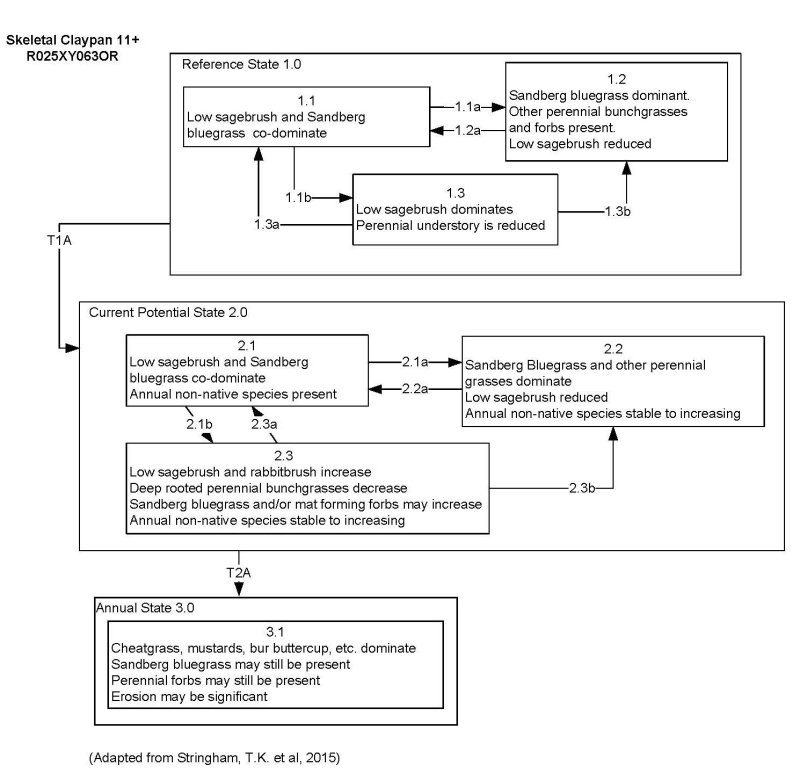
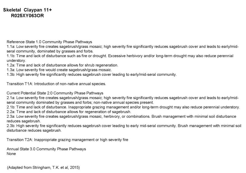
This ecological site is on gently sloping foothills and broad tablelands associated with volcanic plateau landscapes. Elevations range from 4,300 to 6,500 ft. The soils associated with this site are very shallow or shallow to a duripan or lithic contact and have an abrupt boundary in the top 10 inches resulting in wet non-satiated conditions. These soils have high amounts of gravels, cobbles, or stones on the surface which occupy plant growing space yet protect the soil from excessive erosion. The available water capacity is low due to a high volume of rock fragments throughout the profile, but the surface cover of rock fragments helps to reduce evaporation and conserve soil moisture. Lower water holding capacity results in lower overall site production. The soil climate is frigid. The reference plant community is characterized by low sagebrush in the overstory and Sandberg bluegrass in the understory.
(wet non-saturated conditions - Schoeneberger, P.J., 2012, pg 1-15)
Associated sites
| R025XY011OR |
VERY SHALLOW 8-13 PZ |
|---|---|
| R025XY061OR |
SHALLOW CLAYPAN 8-11 PZ |
| R025XY016OR |
SHALLOW CLAYPAN 11-13 PZ |
| R025XY018OR |
SHALLOW CLAYPAN 13-16 PZ |
| R025XY064OR |
SHRUBBY SHALLOW CLAYPAN 13-16 PZ |
| R025XY010OR |
LOAMY 8-11 PZ |
| R025XY012OR |
LOAMY 11-13 PZ |
| R025XY014OR |
LOAMY 13-16 PZ |
| R025XY065OR |
SHRUBBY LOAM 13-16 PZ |
Similar sites
| R025XY011OR |
VERY SHALLOW 8-13 PZ This site is on very shallow and shallow soils with high rock fragment content. Production is much lower and vegetation is dominated by stiff sage (Artemesia rigida) and Sandberg bluegrass. |
|---|---|
| R025XY061OR |
SHALLOW CLAYPAN 8-11 PZ This site has higher available water holding capacity resulting in higher production. The perennial deep rooted grass layer is dominated by bluebunch wheatgrass and Sandberg bluegrass. |
| R025XY016OR |
SHALLOW CLAYPAN 11-13 PZ This site has higher available water holding capacity resulting in higher production. The perennial deep rooted grass layer is dominated by Idaho fescue. |
| R025XY018OR |
SHALLOW CLAYPAN 13-16 PZ This site has higher available water holding capacity resulting in higher production. The perennial deep rooted grass layer is dominated by Idaho fescue. |
Table 1. Dominant plant species
| Tree |
Not specified |
|---|---|
| Shrub |
(1) Artemisia arbuscula |
| Herbaceous |
(1) Poa secunda |
Click on box and path labels to scroll to the respective text.

