Natural Resources
Conservation Service
Ecological site R028AY121NV
DEEP LOAMY 8-10 P.Z.
Last updated: 6/12/2025
Accessed: 04/15/2026
General information
Provisional. A provisional ecological site description has undergone quality control and quality assurance review. It contains a working state and transition model and enough information to identify the ecological site.
MLRA notes
Major Land Resource Area (MLRA): 028A–Ancient Lake Bonneville
MLRA 28A occurs in Utah (82%), Nevada (16%), and Idaho (2%). It makes up about 36,775 square miles. A large area west and southwest of Great Salt Lake is a salty playa. This area is the farthest eastern extent of the Great Basin Section of the Basin and Range Province of the Intermontane Plateaus. It is an area of nearly level basins between widely separated mountain ranges trending north to south. The basins are bordered by long, gently sloping alluvial fans. The mountains are uplifted fault blocks with steep side slopes. They are not well dissected because of low rainfall in the MLRA. Most of the valleys are closed basins containing sinks or playa lakes. Elevation ranges from 3,950 to 6,560 ft. in the basins and from 6,560 to 11,150 ft. in the mountains. Most of this area has alluvial valley fill and playa lakebed deposits at the surface. Great Salt Lake is all that remains of glacial Lake Bonneville. A level line on some mountain slopes indicates the former extent of this glacial lake. Most of the mountains in the interior of this area consist of tilted blocks of marine sediments from Cambrian to Mississippian age. Scattered outcrops of Tertiary continental sediments and volcanic rocks are throughout the area. The average annual precipitation is 5 to 12 ins. in the valleys and is as much as 49 ins. in the mountains. Most of the rainfall occurs as high-intensity, convective thunderstorms during the growing season. The driest period is from midsummer to early autumn. Precipitation in winter typically occurs as snow. The average annual temperature is 39 to 53 °F. The freeze-free period averages 165 days and ranges from 110 to 215 days, decreasing in length with elevation. The dominant soil orders in this MLRA are Aridisols, Entisols, and Mollisols. The soils in the area dominantly have a mesic or frigid soil temperature regime, an aridic or xeric soil moisture regime, and mixed mineralogy. They generally are well drained, loamy or loamy-skeletal, and very deep.
Ecological site concept
This site is occurs on fan aprons. Slopes range from 0 to 8 percent. Elevations are from 5700 feet to about 5900 feet.
The climate associated with this site is semiarid, characterized by cool, moist winters and warm, dry summers. Average annual precipitation is 8 to 10 inches. Mean annual air temperature is 44 to 50 degrees F. The average growing season is about 90 to 120 days.
The soils associated with this site are very deep and well drained. These soils have formed in silty alluvium from mixed rock sources. Surface textures are generally silt loams or very fine sandy loams. Surface soils may be slightly to moderately alkaline but soil reaction decreases with soil depth. Soils have very low to low runoff and have moderately rapid permeability. Many areas receive additional moisture as run-in from higher landscapes.
The reference state is dominated by basin wildrye and basin big sagebrush. Production ranges from 900 to 2200 pounds per acre.
Associated sites
| R028AY013NV |
SHALLOW CALCAREOUS LOAM 8-10 P.Z. |
|---|---|
| R028AY015NV |
LOAMY 8-10 P.Z. |
| R028AY030NV |
SILTY 8-10 P.Z. |
Similar sites
| R028AY025NV |
DRY FLOODPLAIN ELCI2-ELTR3 codominant grasses |
|---|---|
| R028AY091NV |
LOAMY FAN 10-14 P.Z. Less productive site; ARTRV dominant shrub |
| R028AY122NV |
DEEP SODIC LOAM 8-10 P.Z. SAVE4 important shrub |
| R028BY045NV |
LOAMY FAN 8-12 P.Z. Less productive site |
| R028AY092NV |
LOAMY 12-14 P.Z. Less productive site; HECO26 codominant grass |
| R028BY041NV |
DRY FLOODPLAIN Occurs on floodplains; SAVE4 often important shrub |
| R028AY008NV |
SODIC TERRACE 8-10 P. Z. Less productive site; SAVE4 codominant shrub |
Table 1. Dominant plant species
| Tree |
Not specified |
|---|---|
| Shrub |
(1) Artemisia tridentata ssp. tridentata |
| Herbaceous |
(1) Leymus cinereus |
Physiographic features
This site is occurs on fan aprons. Slopes range from 0 to 8 percent. Elevations are from 5700 feet to about 5900 feet.
Table 2. Representative physiographic features
| Landforms |
(1)
Fan apron
|
|---|---|
| Flooding duration | Very brief (4 to 48 hours) |
| Flooding frequency | Rare to occasional |
| Ponding frequency | None |
| Elevation | 5,700 – 5,900 ft |
| Slope | 8% |
| Aspect | Aspect is not a significant factor |
Climatic features
Nevada’s climate is predominantly arid, with large daily ranges of temperature, infrequent severe storms, heavy snowfall in the higher mountains, and great location variations with elevation. Three basic geographical factors largely influence Nevada’s climate: continentality, latitude, and elevation. Continentality is the most important factor. The strong continental effect is expressed in the form of both dryness and large temperature variations. Nevada lies on the eastern, lee side of the Sierra Nevada Range, a massive mountain barrier that markedly influences the climate of the State. The prevailing winds are from the west, and as the warm moist air from the Pacific Ocean ascend the western slopes of the Sierra Range, the air cools, condensation occurs and most of the moisture falls as precipitation. As the air descends the eastern slope, it is warmed by compression, and very little precipitation occurs. The effects of this mountain barrier are felt not only in the West but throughout the state, with the result that the lowlands of Nevada are largely desert or steppes. The temperature regime is also affected by the blocking of the inland-moving maritime air. Nevada sheltered from maritime winds, has a continental climate with well-developed seasons and the terrain responds quickly to changes in solar heating.
Nevada lies within the mid-latitude belt of prevailing westerly winds which occur most of the year. These winds bring frequent changes in weather during the late fall, winter and spring months, when most of the precipitation occurs. To the south of the mid-latitude westerlies, lies a zone of high pressure in subtropical latitudes, with a center over the Pacific Ocean. In the summer, this high-pressure belt shifts northward over the latitudes of Nevada, blocking storms from the ocean. The resulting weather is mostly clear and dry during the summer and early fall, with scattered thundershowers. The eastern portion of the state receives significant summer thunderstorms generated from monsoonal moisture pushed up from the Gulf of California, known as the North American monsoon. The monsoon system peaks in August and by October the monsoon high over the Western U.S. begins to weaken and the precipitation retreats southward towards the tropics (NOAA 2004).
The climate associated with this site is semiarid, characterized by cool, moist winters and warm, dry summers. Average annual precipitation is 8 to 10 inches. Mean annual air temperature is 44 to 50 degrees F. The average growing season is about 90 to 120 days.
Mean annual precipitaion at the LUND, NEVADA climate station (264745) is 10.04 inches.
January 0.78; February 0.85; March 1; April 0.98:
May 0.95; June 0.82; July 0.69; August 0.87;
September 0.77; October 0.92; November 0.69;
December 0.73.
Table 3. Representative climatic features
| Frost-free period (average) | |
|---|---|
| Freeze-free period (average) | 105 days |
| Precipitation total (average) | 9 in |
Figure 1. Monthly average minimum and maximum temperature
Figure 2. Annual precipitation pattern
Figure 3. Annual average temperature pattern
Influencing water features
Many areas receive additional moisture as run-in from higher landscapes.
Soil features
The soils associated with this site are very deep and well drained. These soils have formed in silty alluvium from mixed rock sources. Surface textures are generally silt loams or very fine sandy loams. Surface soils may be slightly to moderately alkaline but soil reaction decreases with soil depth. Soils have very low to low runoff and have moderately rapid permeability. Many areas receive additional moisture as run-in from higher landscapes. Soil series associated with this site include: Atlanta.
The representative soil series is Atlanta, a Coarse-loamy, mixed, superactive, mesic Xeric Haplocalcids. Diagnostic horizons include an Ochric epipedon from the soil surface to a depth of 18 cm, and a Calcic horizon from 25 to 58 cm. Clay content in the particle control section averages 8 to 18 percent. Rock fragments range from 15 to 35 percent, mainly gravel; individual strata range from 0 to 65 percent. Reaction is Moderately or strongly alkaline. Effervescence is violently effervescent. Lithology consists of limestone.
Table 4. Representative soil features
| Parent material |
(1)
Alluvium
–
limestone
|
|---|---|
| Surface texture |
(1) Fine sandy loam |
| Family particle size |
(1) Loamy |
| Drainage class | Well drained |
| Permeability class | Moderate to moderately rapid |
| Soil depth | 55 – 60 in |
| Surface fragment cover <=3" | Not specified |
| Surface fragment cover >3" | Not specified |
| Available water capacity (0-40in) |
4.2 – 4.3 in |
| Calcium carbonate equivalent (0-40in) |
15 – 35% |
| Electrical conductivity (0-40in) |
Not specified |
| Sodium adsorption ratio (0-40in) |
Not specified |
| Soil reaction (1:1 water) (0-40in) |
8 – 8.6 |
| Subsurface fragment volume <=3" (Depth not specified) |
15 – 35% |
| Subsurface fragment volume >3" (Depth not specified) |
Not specified |
Ecological dynamics
An ecological site is the product of all the environmental factors responsible for its development and it has a set of key characteristics that influence a site’s resilience to disturbance and resistance to invasives. Key characteristics include 1) climate (precipitation, temperature), 2) topography (aspect, slope, elevation, and landform), 3) hydrology (infiltration, runoff), 4) soils (depth, texture, structure, organic matter), 5) plant communities (functional groups, productivity), and 6) natural disturbance regime (fire, herbivory, etc.) (Caudle et al 2013). Biotic factors that influence resilience include site productivity, species composition and structure, and population regulation and regeneration (Chambers et al. 2013).
The Great Basin sagebrush communities have high spatial and temporal variability in precipitation both among years and within growing seasons. Nutrient availability is typically low but increases with elevation and closely follows moisture availability. The moisture resource supporting the greatest amount of plant growth is usually the water stored in the soil profile during the winter. The invasibility of plant communities is often linked to resource availability. Disturbance can decrease resource uptake due to damage or mortality of the native species and depressed competition or can increase resource pools by the decomposition of dead plant material following disturbance. The invasion of sagebrush communities by cheatgrass has been linked to disturbances (fire, abusive grazing) that have resulted in fluctuations in resources (Chambers et al 2007).
This ecological site is dominated by the deep-rooted cool season, perennial bunchgrasses such as basin wildrye and long-lived shrubs (50+ years) such as basin big sagebrush and Wyoming big sagebrush. These shrubs have high root to shoot ratios. Root length of mature big sagebrush plants was measured to a depth of 2 meters in alluvial soils in Utah (Richards and Caldwell 1987). These shrubs have a flexible generalized root system with development of both deep taproots and laterals near the surface (Comstock and Ehleringer 1992). Differences in root depth distribution between grasses and shrubs result in resource partitioning in this system.
The perennial bunchgrasses generally have somewhat shallower root systems than the shrubs, but root densities are often as high as or higher than those of shrubs in the upper 0.5 m but taper off more rapidly than shrubs. However, basin wildrye is weakly rhizomatous and has been found to root to depths of up to 2 meters and to exhibit greater lateral root spread than many other grass species (Abbott et al. 1991, Reynolds and Fraley 1989).
Basin wildrye is a large, cool-season perennial bunchgrass with an extensive deep coarse fibrous root system (Reynolds and Fraley 1989). Clumps may reach up to six feet in height (Ogle et al 2012b). Basin wildrye does not tolerate long periods of inundation; it prefers cycles of wet winters and dry summers and is most commonly found in deep soils with high water holding capacities or seasonally high water tables (Ogle et al 2012b, Perryman and Skinner 2007).
This ecological site has moderate resilience to disturbance and resistance to invasion. A primary disturbance on these ecological sites is drought, fire, flooding, Aroga infestation (Aroga websteri), and groundwater pumping that may lead to a lowered seasonal water table. This facilitates an increase in shrubs and a decrease in basin wildrye. The introduction of annual weedy species, like cheatgrass (Bromus tectorum), may cause an increase in fire frequency and eventually lead to an annual state or a state dominated by rabbitbrush. Other troublesome non-native weeds such as broadleaved pepperweed or tall whitetop (Lepidium latifolium), hoary cress or whitetop (Cardaria draba), scotch cottonthistle (Onopordum acanthium) or bull thistle (Cirsium vulgare) are potential invaders on this site. Two possible alternative stable states have been identified
As ecological condition declines density of basin wildrye is reduced while basin big sagebrush increases in the overstory. With continued site degradation, a nearly pure stand of basin big sagebrush is obtained that covers a barren understory. Rabbitbrush may dominate the visual aspect of this site following wildfire.
Fire Ecology:
Grassland communities with a basin wildrye component historically experienced mostly infrequent to frequent stand replacing fires. Grassland vegetation types experienced both short fire intervals of less than 35 years as well as intervals ranging from 35 to 100 years, depending on climate and ignition sources. Basin wildrye is top-killed by fire. Older basin wildrye plants with large proportions of dead material within the perennial crown can be expected to show higher mortality due to fire than younger plants having little debris. Basin wildrye is generally tolerant of fire but may be damaged by early season fire combined with dry soil conditions. Basin big sagebrush is readily killed when aboveground plant parts are charred by fire. Prolific seed production from nearby unburned plants coupled with high germination rates enables seedlings to establish rapidly following fire.
State and transition model

Figure 4. P Novak-Echenique 8/2017

Figure 5. Legend
More interactive model formats are also available.
View Interactive Models
More interactive model formats are also available.
View Interactive Models
Click on state and transition labels to scroll to the respective text
Ecosystem states
State 1 submodel, plant communities
State 3 submodel, plant communities
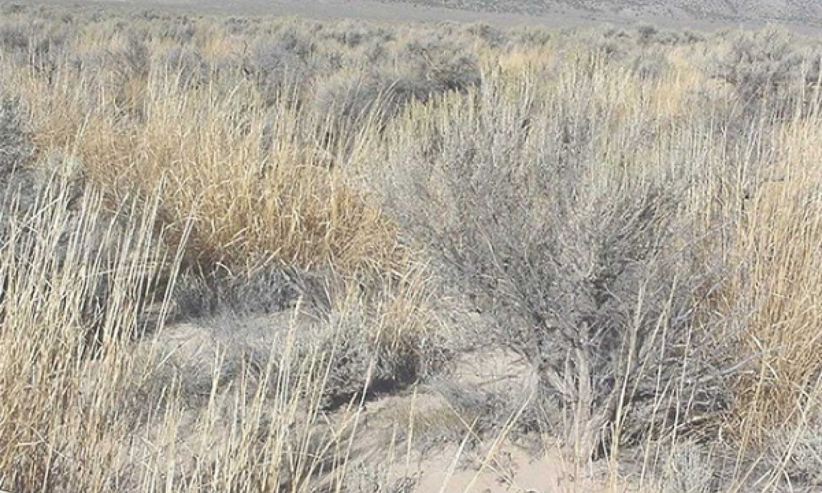
State 1
Reference State
Community 1.1
Basin wildrye/basin big sagebrush

Figure 6. Deep Loamy 8-10", Soil Series- Atlanta, P.Novak-Echenique 6/2012
The reference plant community is dominated by basin wildrye and basin big sagebrush. Potential vegetative composition is about 80% grasses, 5% forbs, and 15% shrubs. Approximate ground cover (basal and crown) is 20 to 35 percent.
Figure 7. Annual production by plant type (representative values) or group (midpoint values)
Table 5. Annual production by plant type
| Plant type | Low (lb/acre) |
Representative value (lb/acre) |
High (lb/acre) |
|---|---|---|---|
| Grass/Grasslike | 720 | 1200 | 1760 |
| Shrub/Vine | 135 | 225 | 330 |
| Forb | 45 | 75 | 110 |
| Total | 900 | 1500 | 2200 |
Community 1.2
Basin wildrye
This community phase is characteristic of a post-disturbance, early-seral community. Basin wildrye and other perennial bunchgrasses dominate. Rubber rabbitbrush may be sprouting. Depending on fire severity or intensity of Aroga moth infestations, patches of intact big sagebrush may remain.
Community 1.3
Basin big sagebrush/basin wildrye
Basin big sagebrush increases in the absence of disturbance. Decadent big sagebrush and/or rubber rabbitbrush dominates the overstory and the deep-rooted perennial bunchgrasses in the understory are reduced either from competition with shrubs and/or from herbivory. Wyoming big sagebrush and black greasewood may also be present.
Pathway 1.1a
Community 1.1 to 1.2
Low severity fire creates a grass/sagebrush mosaic. High severity fire significantly reduces sagebrush cover and leads to a plant community dominated by grasses and forbs.
Pathway 1.1b
Community 1.1 to 1.3
Time and lack of disturbance (fire or drought). Excessive herbivory may also decrease perennial understory.
Pathway 1.2a
Community 1.2 to 1.1
Time and lack of disturbance allows for shrub regeneration.
Pathway 1.3a
Community 1.3 to 1.1
A low severity fire, aroga moth, or a combination of these will reduce the sagebrush overstory and allow grasses to increase.
Pathway 1.3b
Community 1.3 to 1.2
High severity fire significantly reduces sagebrush cover and allows grass to dominate.
State 2
Current Potential State
This state is similar to the Reference State 1 with three similar community phases. Ecological function has not changed, however the resiliency of the state has been reduced by the presence of invasive weeds. Non-natives may increase in abundance but will not become dominant within this State. These non-natives can be highly flammable and can promote fire where historically fire had been infrequent. Negative feedbacks enhance ecosystem resilience and contribute to the stability of the state. These feedbacks include the presence of all structural and functional groups, low fine fuel loads, and retention of organic matter and nutrients. Positive feedbacks decrease ecosystem resilience and stability of the state. These include the non-natives’ high seed output, persistent seed bank, rapid growth rate, ability to cross pollinate, and adaptations for seed dispersal. A site may be consider
Community 2.1
Basin wildrye/basin big sagebrush/non-native species
This community phase is similar to the Reference State Community Phase 1.1, but non-native species are present in trace amounts. Basin wildrye and basin big sagebrush dominate the site. Wyoming big sagebrush may also be present. Seeded species such as crested wheatgrass may be present and/or dominate the understory. Forbs and other shrubs and grasses make up smaller components of this site.
Community 2.2
Basin wildrye/annual non-native species
This community phase is characteristic of a post-disturbance, early seral community where annual non-native species are present. Sagebrush is present in trace amounts; perennial bunchgrasses dominate the site. Depending on fire severity or intensity of Aroga moth infestations, patches of intact sagebrush may remain. Rabbitbrush may be sprouting. Seeded species such as crested wheatgrass may be present and/or dominate the understory. Perennial forbs may be a significant component after fire
Community 2.3
Basin big sagebrush/basin wildrye/annual non-native species (At-risk)
This community is at risk of crossing a threshold to another state. Basin big sagebrush dominates the overstory and perennial bunchgrasses in the understory are reduced, either from competition with shrubs or from inappropriate grazing, or from both. Wyoming big sagebrush and black greasewood may also be present. Rabbitbrush may be a significant component. Annual nonnatives species may be stable or increasing due to lack of competition with perennial bunchgrasses. Seeded species such as crested wheatgrass (Agropyron cristatum) may be present. This site is susceptible to further degradation from grazing, drought, and fire.
Pathway 2.1a
Community 2.1 to 2.2
Low severity fire creates a grass/sagebrush mosaic. A high severity fire significantly reduces sagebrush cover and leads to a grass and forb dominated community. Non-native annual species are present.
Pathway 2.1b
Community 2.1 to 2.3
Time and lack of disturbance (fire or drought). Inappropriate grazing management may also reduce perennial understory.
Pathway 2.2a
Community 2.2 to 2.1
Time and lack of disturbance allows for shrubs to regenerate.
Pathway 2.3a
Community 2.3 to 2.1
A low severity fire, aroga moth, or combination of these will reduce some of the sagebrush overstory and allow grass to increase. May also be caused by brush management with minimal soil disturbance or late season grazing that causes mechanical damage to sagebrush.
Pathway 2.3b
Community 2.3 to 2.2
High severity fire significantly reduces sagebrush cover and allows grass species to dominate.
State 3
Shrub State
This state is a product of many years of heavy grazing during time periods harmful to perennial bunchgrasses. Basin wildrye is significantly reduced and other perennial grasses such as beardless wildrye will increase. Big sagebrush dominates the overstory and rabbitbrush may be a significant component. Big sagebrush cover exceeds site concept and may be decadent, reflecting stand maturity and lack of seedling establishment due to competition with mature plants. The shrub overstory and shallower rooted grasses dominate site resources such that soil water, nutrient capture, nutrient cycling and soil organic matter are temporally and spatially redistributed.
Community 3.1
Big sagebrush
Decadent big sagebrush dominates the overstory. Rabbitbrush and black greasewood may be significant components. Deep-rooted perennial bunchgrasses may be present in trace amounts or absent from the community. Creeping wildrye is present but may be found only in patches. Annual non-native species increase. Crested wheatgrass may be a significant component in this phase if the site has a history of seeding treatments. Bare ground is significant.
Community 3.2
Rabbitbrush
Rabbitbrush increases when a fire or other disturbance removes the sagebrush.
Pathway 3.1a
Community 3.1 to 3.2
Fire or brush treatment with minimal soil disturbance.
Transition T1A
State 1 to 2
Introduction of annual non-native species.
Transition T2A
State 2 to 3
Time and lack of disturbance. This may be coupled with grazing management or hydrologic changes that favor shrubs over perennial grasses.
Restoration pathway R3A
State 3 to 2
Mechanical or chemical brush treatment coupled with herbicide. Seeding of perennial bunch grasses may be necessary.
Additional community tables
Table 6. Community 1.1 plant community composition
| Group | Common name | Symbol | Scientific name | Annual production (lb/acre) | Foliar cover (%) | |
|---|---|---|---|---|---|---|
|
Grass/Grasslike
|
||||||
| 1 | Primary Perennial Grasses | 1050–1275 | ||||
| basin wildrye | LECI4 | Leymus cinereus | 1050–1275 | – | ||
| 2 | Secondary Perennial Grasses | 30–120 | ||||
| Indian ricegrass | ACHY | Achnatherum hymenoides | 8–45 | – | ||
| squirreltail | ELEL5 | Elymus elymoides | 8–45 | – | ||
| western wheatgrass | PASM | Pascopyrum smithii | 8–45 | – | ||
|
Forb
|
||||||
| 3 | Perennial | 30–120 | ||||
| Indian ricegrass | ACHY | Achnatherum hymenoides | 45–90 | – | ||
| squirreltail | ELEL5 | Elymus elymoides | 45–90 | – | ||
| milkvetch | ASTRA | Astragalus | 8–30 | – | ||
| lupine | LUPIN | Lupinus | 8–30 | – | ||
|
Shrub/Vine
|
||||||
| 4 | Primary Shrubs | 150–300 | ||||
| basin big sagebrush | ARTRT | Artemisia tridentata ssp. tridentata | 150–300 | – | ||
| 5 | Secondary Shrubs | 1–75 | ||||
| yellow rabbitbrush | CHVI8 | Chrysothamnus viscidiflorus | 8–30 | – | ||
| rubber rabbitbrush | ERNA10 | Ericameria nauseosa | 8–30 | – | ||
Interpretations
Animal community
Livestock Interpretations:
This site is suited to livestock production. Grazing management should be keyed to basin wildrye production. The early growth and abundant production of basin wildrye make it a valuable source of forage for livestock. It is important forage for cattle and is readily grazed by cattle and horses in early spring and fall. Though coarse-textured during the winter, basin wildrye may be utilized more frequently by livestock and wildlife when snow has covered low shrubs and other grasses. Basin big sagebrush may serve as emergency food during severe winter weather, but it is not usually sought out by livestock.
Stocking rates vary over time depending upon season of use, climate variations, site, and previous and current management goals. A safe starting stocking rate is an estimated stocking rate that is fine tuned by the client by adaptive management through the year and from year to year.
Wildlife Interpretations:
Basin big sagebrush is the least palatable of all the subspecies of big sagebrush. Basin big sagebrush is browsed by mule deer from fall to early spring, but is not preferred. Basin wildrye provides winter forage for mule deer, though use is often low compared to other native grasses. Basin wildrye provides summer forage for black-tailed jackrabbits. Because basin wildrye remains green throughout early summer, it remains available for small mammal forage for a longer time than other grasses.
Hydrological functions
Permeability is moderately rapid. Runoff is very low to low.
Recreational uses
Aesthetic value is derived from the diverse floral and faunal composition and the colorful flowering of wild flowers and shrubs during the spring and early summer. This site offers rewarding opportunities to photographers and for nature study. This site is used for camping and hiking and has potential for upland and big game hunting.
Other products
Some Native American peoples used the bark of big sagebrush to make rope and baskets. Basin wildrye was used as bedding for various Native American ceremonies, providing a cool place for dancers to stand.
Other information
Basin big sagebrush shows high potential for range restoration and soil stabilization. Basin big sagebrush grows rapidly and spreads readily from seed. Basin wildrye is useful in mine reclamation, fire rehabilitation and stabilizing disturbed areas. Its usefulness in range seeding, however, may be limited by initially weak stand establishment.
Supporting information
Type locality
| Location 1: White Pine County, NV | |
|---|---|
| Township/Range/Section | T10N R67E S18 |
| Latitude | 38° 44′ 2″ |
| Longitude | 114° 29′ 51″ |
| General legal description | UTMn 04291254 UTMe 0717492 NAD 27 About 7 miles south of Shoshone, east of USHwy 93 along Highline Road, Spring Valley area, White Pine County, Nevada. This site also occurs in Elko, and Lincoln Counties, Nevada. |
Other references
Abbott, M. L., L. Fraley Jr., and T. D. Reynolds. 1991. Root profiles of selected cold desert shrubs and grasses in disturbed and undisturbed soils. Environmental and Experimental Botany 31(2): 165-178.
Akinsoji, A. 1988. Postfire vegetation dynamics in a sagebrush steppe in southeastern Idaho, USA. Vegetatio 78:151-155.
Baker, W. L. 2006. Fire and restoration of sagebrush ecosystems. Wildlife Society Bulletin 34:177-185.
Baker, W. L. 2011. Pre-euro-american and recent fire in sagebrush ecosystems. Pp 185-201 In S. T. Knick and J. W. Connelly, editors. Greater Sage-grouse: Ecology and Conservation of a Landscape Species and its Habitats. University of California Press, Berkeley, California.
Balch, J. K., B. A. Bradley, C. M. D'Antonio, and J. Gómez-Dans. 2013. Introduced annual grass increases regional fire activity across the arid western USA (1980–2009). Global Change Biology 19:173-183.
Beale, D. M. and A.D. Smith. 1970. Forage use, water consumption, and productivity of pronghorn antelope in western Utah. The Journal of Wildlife Management. 34: 570-582.
Blaisdell, J. P. 1953. Ecological effects of planned burning of sagebrush-grass range on the upper Snake River Plains. US Dept. of Agriculture.
Booth, DT. 1985. The role of fourwing saltbush in mined land reclamation: A viewpoint. Journal of Range Management. 28:562-565.
Bradley, A. F., N. V. Noste, and W. C. Fischer. 1992. Gen. Tech. Rep. INT-287: Fire Ecology of Forests and Woodlands in Utah. . U.S. Department of Agriculture, Forest Service, Intermountain Research Station, Ogden, UT.
Brown, K.W. 1977. Food habits of desert bighorn sheep in Nevada, 1956–1976. Desert Bighorn Council Transactions, 21: 32–60.
Bunting, S. C., B. M. Kilgore, and C. L. Bushey. 1987. Guidelines for Prescribed Burning Sagebrush-grass Rangelands in the Northern Great Basin. US Department of Agriculture, Forest Service, Intermountain Research Station Ogden, UT, USA.
Caudle, D., J. DiBenedetto, M. Karl, H. Sanchez, and C. Talbot. 2013. Interagency Ecological Site Handbook for Rangelands. Available at: http://jornada.nmsu.edu/sites/jornada.nmsu.edu/files/InteragencyEcolSiteHandbook.pdf. Accessed 4 October 2013.
Chambers, J., B. Bradley, C. Brown, C. D’Antonio, M. Germino, J. Grace, S. Hardegree, R. Miller, and D. Pyke. 2013. Resilience to stress and disturbance, and resistance to Bromus tectorum L. invasion in cold desert shrublands of western North America. Ecosystems:1-16.
Chambers, J.C., B.A. Roundy, R.R. Blank, S.E. Meyer, and A. Whittaker. 2007. What makes Great Basin sagebrush ecosystems invasible by Bromus tectorum? Ecological Monographs 77:117-145.
Comstock, J. P. and J. R. Ehleringer. 1992. Plant adaptation in the Great Basin and Colorado plateau. Western North American Naturalist 52:195-215.
Dobbs, R. C., P. R. Martin and T. E. Martin. 2012. Green-tailed Towhee (Pipilo chlorurus), The Birds of North America Online (A. Poole, Ed.). Ithaca: Cornell Lab of Ornithology; Retrieved from the Birds of North America Online: < http://bna.birds.cornell.edu/bna/species/368 doi:10.2173/ bna.368>
Eckert, R. E., Jr., A. D. Bruner, and G. J. Klomp. 1973. Productivity of tall wheatgrass and Great Basin wildrye under irrigation on a greasewood-rabbitbrush range site. Journal of Range Management 26:286-288.
Evans, R. A. and J. A. Young. 1978. Effectiveness of rehabilitation practices following wildfire in a degraded big sagebrush-downy brome community. Journal of Range Management 31:185-188.
Fire Effects Information System (Online; http://www.fs.fed.us/database/feis/plants/).
Ganskopp, D., L. Aguilera, and M. Vavra. 2007. Livestock forage conditioning among six northern Great Basin grasses. Rangeland Ecology & Management 60:71-78.
Goodrich, S., E. D. McArthur, and A. H. Winward. 1985. A new combination and a new variety in Artemisia tridentata. The Great Basin Naturalist 45:99-104.
Green, J.S. and J.T. Flinders. 1980. Habitat and dietary relationships of the pygmy rabbit. J. Range Manage. 33:136-142.
Hickey, Jr., W.C. and H.W. Springfield. 1966. Alkali sacaton: its merits for forage and cover. Journal of Range Management 19(2):71-74.
Houghton, J.G., C.M. Sakamoto, and R.O. Gifford. 1975. Nevada’s Weather and Climate, Special Publication 2. Nevada Bureau of Mines and Geology, Mackay School of Mines, University of Nevada, Reno, NV.
Humphrey, L. D. 1984. Patterns and mechanisms of plant succession after fire on Artemisia-grass sites in southeastern Idaho. Vegetatio 57:91-101.
Johnson, J. R. and G. F. Payne. 1968. Sagebrush reinvasion as affected by some environmental influences. Journal of Range Management 21:209-213.
Knick, S.T., D.S. Dobkin, J.T. Rotenberry, M.A. Schroeder, W.M.V. Haegen, and C. Van Riper III. 2003. Teetering on the edge or too late? Conservation and research issues for avifauna of sagebrush habitats. The Condor. 105:611-634.
Krall, J. L., J. R. Stroh, C. S. Cooper, and S. R. Chapman. 1971. Effect of time and extent of harvesting basin wildrye. Journal of Range Management 24:414-418.
Larrison, C.J. and D.R. Johnson 1973. Density changes and habitat affinities of rodents of shadscale and sagebrush associations. Great Basin Naturalist. 33:255-264.
Lulow, M. E. 2006. Invasion by non-native annual grasses: The importance of species biomass, composition, and time among California native grasses of the Central Valley. Restoration Ecology, 14(4), 616-626.
Majerus, M. E. 1992. High-stature grasses for winter grazing. Journal of soil and water conservation 47:224-225.
Marcum, K.B. and D.H. Kopec. 1997. Salinity tolerance of turfgrasses and alternative species in the subfamily Chloridoideae (Poaceae). International Turfgrass Society Research Journal 8:735-742.
McKell, C. M. and W. W. Chilcote. 1957. Response of Rabbitbrush Following Removal of Competing Vegetation. Journal of Range Management Archives 10:228-229.
Miller, R. F., J. C. Chambers, D. A. Pyke, F. B. Pierson, and C. J. Williams. 2013. A review of fire effects on vegetation and soils in the Great Basin Region: response and ecological site characteristics.
National Oceanic and Atmospheric Administration. 2004. The North American Monsoon. Reports to the Nation. National Weather Service, Climate Prediction Center. Available online: http://www.weather.gov/.
Ogle, D.G., St. John, L., and D. Tilley. 2012b. Plant Guide for Fourwing Saltbush (Atriplex canescens). USDA Natural Resources Conservation Service, Aberdeen, ID Plant Materials Center. 83210-0296.
Ogle, D.G., Tilley, D., and L. St. John. 2012a. Plant Guide for basin wildrye (Leymus cinereus). USDA-Natural Resources Conservation Service, Aberdeen Plant Materials Center. Aberdeen, Idaho.
Paysen, T. E., R. J. Ansley, J. K. Brown, G. J. Gottfried, S. M. Haase, M. G. Harrington, M. G. Narog, S. S. Sackett, and R. C. Wilson. 2000. Fire in Western Shrubland, Woodland, and Grassland Ecosystems. Wildland Fire in Ecosystems: Effects of fire on flora. Gen. Tech. Rep. RMRS-GTR-42-vol 2:121-159.
Perryman, B.L. and Q.D. Skinner. 2007. A Field Guide to Nevada Grasses. Indigenous Rangeland Management Press, Lander, Wyoming. 256 p.
Plummer, A.P., D.R. Christensen, and S.B. Monsen. 1968. Restoring big-game range in Utah. Utah Division of Fish and Game Publication No. 683.
Reynolds, T.D., and L. Fraley Jr. 1989. Root profiles of some native and exotic plant species in southeastern Idaho. Environmental and Experimental Botany. 29(2): 241-248.
Richards, J. H. and M. M. Caldwell. 1987. Hydraulic lift: Substantial nocturnal water transport between soil layers by Artemisia tridentata roots. Oecologia 73:486-489.
Robberecht, R. and G. Defossé. 1995. The relative sensitivity of two bunchgrass species to fire. International Journal of Wildland Fire 5:127-134.
Roundy, B. A. 1985. Emergence and establishment of basin wildrye and tall wheatgrass in relation to moisture and salinity. Journal of Range Management 38:126-131.
Sapsis, D. B. and J. B. Kauffman. 1991. Fuel consumption and fire behavior associated with prescribed fires in sagebrush ecosystems. Northwest Science 65:173-179.
Sheehy, P.D. and A.H. Winward. 1981. Relative palatability of seven Artemisia taxa to mule deer and sheep. J. Range Manage. 34:397-399.
Shumar, M. L. and J. E. Anderson. 1986. Water relations of two subspecies of big sagebrush on sand dunes in southeastern Idaho. Northwest Science 60:179-185.
Smoliak, S., J. F. Dormaar, and A. Johnston. 1972. Long-term grazing effects on Stipa-Bouteloua prairie soils. Journal of Range Management 25:246-250.
Stringham, T.K., P. Novak-Echenique, P. Blackburn, C. Coombs, D. Snyder and A. Wartgow. 2015. Final Report for USDA Ecological Site Description State-and-Transition Models, Major Land Resource Area 28A and 28B Nevada. University of Nevada Reno, Nevada Agricultural Experiment Station Research Report 2015-01. p. 1524.
Stuart, D. M., G. E. Schuman, and A. S. Dylla. 1971. Chemical characteristics of the coppice dune soils in Paradise Valley, Nevada. Soil Sci. Soc. Am. J. 35:607-611.
Tueller, P. T. and W. H. Blackburn. 1974. Condition and trend of the big sagebrush/needleandthread habitat type in Nevada. Journal of Range Management 27:36-40.
USDA-NRCS Plants Database (Online; http://www.plants.usda.gov).
Wambolt, C.L. 1996. Mule deer and elk foraging preference for 4 sagebrush taxa. J. Range Manage. 49:499-503.
Wambolt, C.L., W.H. Creamer, and R.J. Rossi. 1994. Predicting big sagebrush winter forage by sub-species and browse form class. J. Range Manage. 47:231-234.
Welch B.L., E. D. McArthur, and J.N. Davis. 1981. Differential preference of wintering mule deer for accessions of big sagebrush and for black sagebrush. J. Range Manage. 34:409-411
White, S. M., J.T. Flinders, and B.S. Welch. 1982. Preference of pygmy rabbits (Brachylagus idahoensis) for various populations of big sagebrush (Artemisia tridentata). Journal of Range Management. 35: 724-726.
Wildlife Action Plan Team. 2012. Nevada Wildlife Action Plan. Nevada Department of Wildlife. Reno, Nevada.
Wright, H. A. 1971. Why squirreltail Is more tolerant to burning than needle-and-thread. Journal of Range Management 24:277-284.
Wright, H. A. and A. W. Bailey. 1982. Fire ecology: United States and southern Canada. Wiley & Sons.
Wright, H. A. and J. O. Klemmedson. 1965. Effect of fire on bunchgrasses of the sagebrush-grass region in southern Idaho. Ecology 46:680-688.
Young, J. A. and R. A. Evans. 1981. Germination of Great Basin wildrye seeds collected from native stands. Agron. J. 73:917-920.
Young, J. A., R. A. Evans, and P. T. Tueller. 1976. Great Basin plant communities-pristine and grazed. Holocene environmental change in the Great Basin. Nevada Archeological Survey Research Paper 6:186-215.
Young, R. P. 1983. Fire as a vegetation management tool in rangelands of the intermountain region. Pp.18-31 In Managing Intermountain Rangelands - Improvement of Range and Wildlife Habitats. USDA, Forest Service.
Young-Mathews, A. and S.R. Winslow. 2010. Plant guide for beardless wildrye (Leymus triticoides). USDA-Natural Resources Conservation Service, Plant Materials Center. Lockeford, CA.
Zlatnik, Elena. 1999. Agropyron cristatum. In: Fire Effects Information System, [Online]. U.S. Department of Agriculture, Forest Service, Rocky Mountain Research Station, Fire Sciences Laboratory (Producer). Available: http://www.fs.fed.us/database/feis/
Zschaechner, G. A. 1985. Studying rangeland fire effects: a case study in Nevada. Pp. 66-84 in Rangeland Fire Effects, A Symposium. Bureau of Land Management, Boise, Idaho.
Contributors
PWB/GKB
P NovakEchenique
Approval
Kendra Moseley, 6/12/2025
Rangeland health reference sheet
Interpreting Indicators of Rangeland Health is a qualitative assessment protocol used to determine ecosystem condition based on benchmark characteristics described in the Reference Sheet. A suite of 17 (or more) indicators are typically considered in an assessment. The ecological site(s) representative of an assessment location must be known prior to applying the protocol and must be verified based on soils and climate. Current plant community cannot be used to identify the ecological site.
| Author(s)/participant(s) | P NOVAK-ECHENIQUE |
|---|---|
| Contact for lead author | State Rangeland Management Specialist |
| Date | 07/12/2012 |
| Approved by | Kendra Moseley |
| Approval date | |
| Composition (Indicators 10 and 12) based on | Annual Production |
Indicators
-
Number and extent of rills:
Rills are rare. A few rills can be expected in areas subjected to summer convection storms or rapid spring snowmelt. -
Presence of water flow patterns:
Water flow patterns are none to rare but may occur in areas recently subjected to summer convection storms or rapid snowmelt. -
Number and height of erosional pedestals or terracettes:
Pedestals are rare. Occurrence is usually limited to areas of water flow patterns. Frost heaving of shallow rooted plants should not be considered a "normal" condition. -
Bare ground from Ecological Site Description or other studies (rock, litter, lichen, moss, plant canopy are not bare ground):
Bare ground 50-60% depending on amount of surface rock fragments -
Number of gullies and erosion associated with gullies:
None -
Extent of wind scoured, blowouts and/or depositional areas:
None -
Amount of litter movement (describe size and distance expected to travel):
Fine litter (foliage from grasses and annual & perennial forbs) expected to move distance of slope length during intense summer convection storms or rapid snowmelt events. Persistent litter (large woody material) will remain in place except during large rainfall events. -
Soil surface (top few mm) resistance to erosion (stability values are averages - most sites will show a range of values):
Soil stability values should be 3 to 6 on most soil textures found on this site. (To be field tested.) -
Soil surface structure and SOM content (include type of structure and A-horizon color and thickness):
Surface structure is typically moderate, thick platy. Soil surface colors are yellowish-browns and soils are typified by an ochric epipedon. Organic matter of the surface 2 to 4 inches is typically 1.25 to 3 percent dropping off quickly below. Organic matter content can be more or less depending on micro-topography. -
Effect of community phase composition (relative proportion of different functional groups) and spatial distribution on infiltration and runoff:
Deep-rooted perennial herbaceous bunchgrasses (basin wildrye) slow runoff and increase infiltration. Tall stature and relatively coarse foliage of basin wildrye and associated shrubs break raindrop impact and provide opportunity for snow catch and moisture accumulation on site. -
Presence and thickness of compaction layer (usually none; describe soil profile features which may be mistaken for compaction on this site):
Compacted layers are none. Calcic or massive sub-surface horizon are not to be interpreted as compacted soil layers. -
Functional/Structural Groups (list in order of descending dominance by above-ground annual-production or live foliar cover using symbols: >>, >, = to indicate much greater than, greater than, and equal to):
Dominant:
Reference State: Deep-rooted, cool season perennial bunchgrasses >Tall shrubs (big sagebrush)Sub-dominant:
deep-rooted cool season perennial forbs > associated shrubs > rhizomatous grasses > shallow-rooted, cool season, perennial bunchgrasses > fibrous, shallow-rooted, cool season, perennial and annual forbs.Other:
Additional:
-
Amount of plant mortality and decadence (include which functional groups are expected to show mortality or decadence):
Dead branches within individual shrubs common and standing dead shrub canopy material may be as much as 25% of total woody canopy; mature bunchgrasses may have dead centers (±25%). -
Average percent litter cover (%) and depth ( in):
Reference Plant Community: Under canopy and between plant interspaces (20-35%) and litter depth is ± ½ inch. -
Expected annual annual-production (this is TOTAL above-ground annual-production, not just forage annual-production):
For normal or average growing season (through mid-June) ± 1500lbs/ac; Favorable years 2200 lbs/ac and unfavorable years 000 lbs/ac. -
Potential invasive (including noxious) species (native and non-native). List species which BOTH characterize degraded states and have the potential to become a dominant or co-dominant species on the ecological site if their future establishment and growth is not actively controlled by management interventions. Species that become dominant for only one to several years (e.g., short-term response to drought or wildfire) are not invasive plants. Note that unlike other indicators, we are describing what is NOT expected in the reference state for the ecological site:
Potential invaders on this site include cheatgrass, halogeton, Russian thistle, annual mustards, knapweeds, tall whitetop, and bur buttercup. -
Perennial plant reproductive capability:
All functional groups should reproduce in average (or normal) and above average growing season years. Little growth or reproduction occurs during drought years.
Print Options
Sections
Font
Other
The Ecosystem Dynamics Interpretive Tool is an information system framework developed by the USDA-ARS Jornada Experimental Range, USDA Natural Resources Conservation Service, and New Mexico State University.
Click on box and path labels to scroll to the respective text.