
Natural Resources
Conservation Service
Ecological site F028BY083NV
Cobbly Calcareous Mountain Slopes 10-12 P.Z.
Last updated: 2/19/2025
Accessed: 04/09/2026
General information
Provisional. A provisional ecological site description has undergone quality control and quality assurance review. It contains a working state and transition model and enough information to identify the ecological site.
MLRA notes
Major Land Resource Area (MLRA): 028B–Central Nevada Basin and Range
MLRA 28B occurs entirely in Nevada and comprises about 23,555 square miles (61,035 square kilometers). More than nine-tenths of this MLRA is federally owned. This area is in the Great Basin Section of the Basin and Range Province of the Intermontane Plateaus. It is an area of nearly level, aggraded desert basins and valleys between a series of mountain ranges trending north to south. The basins are bordered by long, gently sloping to strongly sloping alluvial fans. The mountains are uplifted fault blocks with steep sideslopes. Many of the valleys are closed basins containing sinks or playas. Elevation ranges from 4,900 to 6,550 feet (1,495 to 1,995 meters) in the valleys and basins and from 6,550 to 11,900 feet (1,995 to 3,630 meters) in the mountains.
The mountains in the southern half are dominated by andesite and basalt rocks that were formed in the Miocene and Oligocene. Paleozoic and older carbonate rocks are prominent in the mountains to the north. Scattered outcrops of older Tertiary intrusives and very young tuffaceous sediments are throughout this area. The valleys consist mostly of alluvial fill, but lake deposits are at the lowest elevations in the closed basins. The alluvial valley fill consists of cobbles, gravel, and coarse sand near the mountains in the apex of the alluvial fans. Sands, silts, and clays are on the distal ends of the fans.
The average annual precipitation ranges from 4 to 12 inches (100 to 305 millimeters) in most areas on the valley floors. Average annual precipitation in the mountains ranges from 8 to 36 inches (205 to 915 millimeters) depending on elevation. The driest period is from midsummer to midautumn. The average annual temperature is 34 to 52 degrees F (1 to 11 degrees C). The freeze-free period averages 125 days and ranges from 80 to 170 days, decreasing in length with elevation.
The dominant soil orders in this MLRA are Aridisols, Entisols, and Mollisols. The soils in the area dominantly have a mesic soil temperature regime, an aridic or xeric soil moisture regime, and mixed or carbonatic mineralogy. They generally are well drained, loamy or loamyskeletal, and shallow to very deep.
Nevada’s climate is predominantly arid, with large daily ranges of temperature, infrequent severe storms and heavy snowfall in the higher mountains. Three basic geographical factors largely influence Nevada’s climate: continentality, latitude, and elevation. The strong continental effect is expressed in the form of both dryness and large temperature variations. Nevada lies on the eastern, lee side of the Sierra Nevada Range, a massive mountain barrier that markedly influences the climate of the State. The prevailing winds are from the west, and as the warm moist air from the Pacific Ocean ascend the western slopes of the Sierra Range, the air cools, condensation occurs and most of the moisture falls as precipitation. As the air descends the eastern slope, it is warmed by compression, and very little precipitation occurs. The effects of this mountain barrier are felt not only in the West but throughout the state, as a result the lowlands of Nevada are largely desert or steppes.
The temperature regime is also affected by the blocking of the inland-moving maritime air. Nevada sheltered from maritime winds, has a continental climate with well-developed seasons and the terrain responds quickly to changes in solar heating. Nevada lies within the midlatitude belt of prevailing westerly winds which occur most of the year. These winds bring frequent changes in weather during the late fall, winter and spring months, when most of the precipitation occurs.
To the south of the mid-latitude westerlies, lies a zone of high pressure in subtropical latitudes, with a center over the Pacific Ocean. In the summer, this high-pressure belt shifts northward over the latitudes of Nevada, blocking storms from the ocean. The resulting weather is mostly clear and dry during the summer and early fall, with occasional thundershowers. The eastern portion of the state receives noteworthy summer thunderstorms generated from monsoonal moisture pushed up from the Gulf of California, known as the North American monsoon. The monsoon system peaks in August and by October the monsoon high over the Western U.S. begins to weaken and the precipitation retreats southward towards the tropics (NOAA 2004).
Ecological site concept
The Cobbly Calcareous Mountain Slopes 10-12 P.Z. occurs on hills and rock pediments on all exposures. Slopes are typically 8 to 30 percent. Elevations are 5200 to 7500 feet. Soils are shallow, well drained and have over 50 percent gravels and cobbles by volume distributed throughout the profile and formed in residuum and/or colluvium.
The reference state is dominated by very old Utah juniper. Black sagebrush is the principal understory shrub. Indian ricegrass, needle and thread, and Sandberg bluegrass are the most prevalent understory grasses. An overstory canopy of 15 to 25 percent is assumed to be representative. Understory production ranges from 125 to 300 pounds per acre. Occurrences of this site on fan remnants should be considered a treed state of black sagebrush rangeland, not a forest ecological site.
Cobbly Calcareous Mountain Slopes 10-12 P.Z. was previously named JUOS/ARNO4/ACHY-HECO26.
Associated sites
| R028BY011NV |
SHALLOW CALCAREOUS LOAM 8-10 P.Z. This site occurs on fan remnants on all exposures. Slopes gradients of 2 to 10 are typical. Elevations are 5000 to 7000 feet. |
|---|---|
| R028BY016NV |
SHALLOW CALCAREOUS SLOPE 8-10 P.Z. The site typically occurs on hills and mountains. Slopes gradients >30 percent are typical. Elevations range from 5500 to 7500 feet. |
Similar sites
| F028BY060NV |
PIMO-JUOS/ARNO4/PSSPS-ACHY Singleleaf pinyon is co-dominant with Utah juniper. Bluebunch wheatgrass is a dominant grass. Higher site index. |
|---|
Table 1. Dominant plant species
| Tree |
(1) Juniperus osteosperma |
|---|---|
| Shrub |
(1) Artemisia nova |
| Herbaceous |
(1) Achnatherum hymenoides |
Physiographic features
The Cobbly Calcareous Mountain Slopes 10-12 P.Z. site occurs on hills and rock pediments on all exposures. Slopes range from 4 to 50 percent, but are typically 8 to 30 percent. Elevations are 5200 to 7500 feet.
Table 2. Representative physiographic features
| Landforms |
(1)
Hill
(2) Pediment |
|---|---|
| Runoff class | High to very high |
| Elevation | 5,200 – 7,500 ft |
| Slope | 8 – 30% |
| Water table depth | 72 in |
| Aspect | Aspect is not a significant factor |
Table 3. Representative physiographic features (actual ranges)
| Runoff class | Not specified |
|---|---|
| Elevation | Not specified |
| Slope | 4 – 50% |
| Water table depth | Not specified |
Climatic features
The climate is semi-arid. In general it is characterized by cold, moist winters and warm, dry summers.
Average annual precipitation ranges from 10 to 12 inches. Mean annual air temperature is about 45 to 47 degrees F. The average growing season is 100 to 120 days.
Mean annual precipitation at the ELY WBO,NEVADA climate station (262631) is 9.72 inches.
monthly mean precipitation is:
January 0.77; February 0.78; March 1.01; April 1.03;
May 1.10; June 0.65; July 0.64; August 0.81;
September 0.75; October 0.82;
November 0.68; December 0.68.
Table 4. Representative climatic features
| Frost-free period (characteristic range) | 49 days |
|---|---|
| Freeze-free period (characteristic range) | 80 days |
| Precipitation total (characteristic range) | 10 in |
| Frost-free period (actual range) | 49 days |
| Freeze-free period (actual range) | 80 days |
| Precipitation total (actual range) | 10 in |
| Frost-free period (average) | 49 days |
| Freeze-free period (average) | 80 days |
| Precipitation total (average) | 10 in |
Figure 1. Monthly precipitation range
Figure 2. Monthly minimum temperature range
Figure 3. Monthly maximum temperature range
Figure 4. Monthly average minimum and maximum temperature
Figure 5. Annual precipitation pattern
Figure 6. Annual average temperature pattern
Climate stations used
-
(1) ELY YELLAND FLD AP [USW00023154], Ely, NV
Influencing water features
Influencing water features are not associated with this site.
Soil features
Soils are very shallow to shallow, well drained, and have over 50 percent gravels and cobbles by volume distributed throughout the profile. They have formed in residuum weathered from mixed rock material. Soil reaction is slightly to strongly alkaline and soils are calcareous. Available water holding capacity is very low. The soil temperature regime is mesic and the soil moisture regime is aridic bordering on xeric. Soil series associated with this site include: Biken, Hundraw, Izar, and Roden.
Representative soil characteristics are discussed above, at this time there is not a representative soil series. The above mentioned soil series do not meet the site concept and new series will be established.
Table 5. Representative soil features
| Parent material |
(1)
Residuum
–
volcanic rock
(2) Colluvium – volcanic rock |
|---|---|
| Surface texture |
(1) Very gravelly sandy loam (2) Very gravelly fine sandy loam |
| Family particle size |
(1) Loamy |
| Drainage class | Well drained to somewhat excessively drained |
| Permeability class | Slow to moderate |
| Soil depth | 4 – 20 in |
| Surface fragment cover <=3" | 24 – 40% |
| Surface fragment cover >3" | 7% |
| Available water capacity (0-40in) |
0.7 – 2.7 in |
| Calcium carbonate equivalent (0-40in) |
10% |
| Electrical conductivity (0-40in) |
Not specified |
| Sodium adsorption ratio (0-40in) |
Not specified |
| Soil reaction (1:1 water) (0-40in) |
8.3 – 8.8 |
| Subsurface fragment volume <=3" (Depth not specified) |
30 – 60% |
| Subsurface fragment volume >3" (Depth not specified) |
3 – 9% |
Ecological dynamics
An ecological site is the product of all the environmental factors responsible for its development and has a set of key characteristics that influence a site’s resilience to disturbance and resistance to invasives. Key characteristics include 1) climate (precipitation, temperature), 2) topography (aspect, slope, elevation, and landform), 3) hydrology (infiltration, runoff), 4) soils (depth, texture, structure, organic matter), 5) plant communities (functional groups, productivity), and 6) natural disturbance regime (fire, herbivory, etc.) (Caudle et al 2013). Biotic factors that influence resilience include site productivity, species composition and structure, and population regulation and regeneration (Chambers et al. 2013).
Pinyon- and juniper-dominated plant communities in the cold desert of the Intermountain West occupy over 18 million ha (44,600,000 acres) (Miller and Tausch 2001). In the mid to late 1900’s, the number of pinyon and juniper trees establishing per decade began to increase compared to the previous several hundred years. The substantial increase in conifer establishment is attributed to a number of factors, the most important including: (1) cessation of the aboriginal burning (Tausch 1999), (2) change in climate with rising temperatures (Heyerdahl et al. 2006), (3) the reduced frequency of fire likely driven by the introduction of domestic livestock, (4) a decrease in wildfire frequency along with improved wildfire suppression efforts and (5) potentially increased CO2 levels favoring woody plant establishment (Tausch 1999, Bunting 1994). Miller et al. (2008) found presettlement tree densities averaged 2 to 11 per acre in six woodlands studied across the Intermountain West. Current stand densities range from 80 to 358 trees/ac. In Utah, Nevada, and Oregon, trees establishing prior to 1860 accounted for only 2 percent or less of the total population of pinyon and juniper (Miller et al. 2008). Research strongly suggests that for over 200 years prior to settlement, woodlands in the Great Basin were relatively low density with limited rates of establishment (Miller et al. 2008, Miller and Tausch 2001); thus, tree canopy cover of 10 to 20% may be more representative of these sites in pristine condition. Increases in pinyon and juniper densities post-settlement were the result of both infill in mixed age tree communities and expansion into shrub-steppe communities. Pre-settlement trees accounted for less than 2 percent of the stands sampled in Nevada, Oregon and Utah (Miller et al. 2008, Miller and Tausch 2001, Miller et al. 1999). However, the proportion of old-growth can vary depending on disturbance regimes, soils and climate. Some ecological sites are capable of supporting persistent woodlands, likely due to specific soils and climate resulting in infrequent stand replacement disturbance regimes. In the Great Basin, old-growth trees have been found to typically grow on rocky shallow or sandy soils that support little understory vegetation to carry a fire (Holmes et al. 1986, Miller and Rose 1995, West et al. 1998).
Utah Juniper growth is dependent mostly upon soil moisture stored from winter precipitation, mainly snow. Much of the summer precipitation is ineffective, being lost in runoff after summer convection storms or by evaporation and interception (Tueller and Clark 1975). Utah juniper is highly resistant to drought, a disturbance common in the Great Basin. Tap roots have a relatively rapid rate of root elongation and are thus able to persist until precipitation conditions are more favorable (Emerson 1932).
Infilling by younger trees increases canopy cover causing a decrease in understory perennial vegetation and an increase in bare ground. As juniper trees increase in density so does their litter. Phenolic compounds of juniper scales can have an inhibitory effect on grass growth (Jameson 1970). Furthermore, infilling shifts stand level biomass from ground fuels to canopy fuels which has the potential to significantly impact fire behavior. The more tree dominated pinyon and juniper woodlands become, the less likely they are to burn under moderate conditions, resulting in infrequent high intensity fires (Gruell 1999, Miller et al. 2008). Additionally, as the understory vegetation declines in vigor and density with increased canopy the seed and propagules of the understory plant community also decrease significantly. The increase in bare ground allows for the invasion of non-native annual species such as cheatgrass and with intensive wildfire the potential for conversion to annual exotics is a serious threat (Tausch 1999, Miller et al. 2008).
Specific successional pathways after disturbance in Utah juniper stands are dependent on a number of variables such as plant species present at the time of disturbance and their individual responses to disturbance, past management, type and size of disturbance, available seed sources in the soil or adjacent areas, and site and climatic conditions throughout the successional process.
Utah juniper can be killed by a fungus called juniper pocket rot (Pyrofomes demidoffi), also known as white truck rot (Eddleman et al. 1994 and Durham 2014). Pocket rot enters the tree through any wound or opening that exposes the heartwood. In an advanced stage, this fungus can cause high mortality (Durham 2014). Dwarf mistletoe (Phorandendron spp.), a parasitic plant, may also affect Utah juniper and without treatment or pruning, may kill the tree 10-15 years after infection. Seedlings and saplings are most susceptible to dwarf mistletoe (Christopherson 2014). Other diseases affecting juniper include: witches’-broom (Gymnosporangium sp.), which may girdle and kill branches; leaf rust (Gymnosporangium sp.) on leaves and young branches; and juniper blight (Phomopsis sp.). Insects include flat-head borers (Chrysobothris sp.), which attack the wood; long-horned beetles (Methia juniper (Styloxus bicolor) which girdle limbs and twigs; and round-head borers (Callidium spp.), which attack twigs and limbs (Tueller and Clark 1975).
Black sagebrush is generally long-lived; therefore it is not necessary for new individuals to recruit every year for perpetuation of the stand. Infrequent large recruitment events and simultaneous low, continuous recruitment are the foundation of population maintenance (Noy-Meir 1973). Survival of the seedlings is dependent on adequate moisture conditions.
The perennial bunchgrasses that are co-dominant with the shrubs include Indian ricegrass and needleandthread. These species generally have somewhat shallower root systems than the shrubs, but root densities are often as high as or higher than those of shrubs in the upper 0.5 m of the soil profile. General differences in root depth distributions between grasses and shrubs results in resource partitioning in these shrub/grass systems.
The ecological site has low to moderate resilience to disturbance and resistance to invasion. Resilience increases with elevation, aspect, increased precipitation and increased nutrient availability. Two possible alternative stable states have been identified for this site.
Fire Ecology:
Replacement fires were uncommon to rare (100-600 years) and occurred primarily during extreme fire behavior conditions. Spreading, low-intensity surface fires had a very limited role in molding stand structure and dynamics. Surface spread was more likely to occur in higher-density woodlands growing on more productive sites (Romme et al 2007). Pre-settlement fire return intervals in the Great Basin National Park, Nevada were found to have a mean range between 50 to 100 years with north-facing slopes burning every 15 to 20 years and rocky landscapes with sparse understory very infrequently (Gruell 1999). Woodland dynamics are largely attributed to long-term climatic shifts (temperature, amounts and distribution of precipitation) and the extent and return intervals of fire (Miller and Tausch 2001). Limited data exists that describes fire histories across woodlands in the Great Basin. The infilling of younger trees into the old-growth stands and the expansion of trees into the surrounding sagebrush steppe ecological sites has increased the risk of loss of pre-settlement trees due to increased fire severity and size resulting from the increase in the abundance and landscape level continuity of fuels (Miller et al. 2008).
Utah juniper is usually killed by fire, and is most vulnerable to fire when it is under four feet tall (Bradley et al. 1992). Larger trees, because they have foliage farther from the ground and thicker bark, can survive low severity fires but mortality does occur when 60% or more of the crown is scorched (Bradley et al. 1992). Singleleaf pinyons are also most vulnerable to fire when less than four feet tall, however mature trees do not self-prune their dead branches allowing for accumulated fuel in the crowns. This characteristic and the relative flammability of the foliage make individual mature trees susceptible to fire (Bradley et al. 1992). With the low production of the understory vegetation and low density of trees per acre, high severity fires within this plant community were not likely and rarely became crown fires (Bradley et al. 1992, Miller and Tausch 2001).
Initial response of native understory species following fire correlates closely with percent crown cover. In general, research indicates that understory response to disturbance is most productive when crown cover is at or below 20% while beyond 30% there is a rapid decline in understory species and soil seed reserves (Huber et al. 1999). The reference state understory vegetation of black sagebrush, needleandthread and Indian ricegrass further supports the evidence of a presettlement community with an open overstory and infrequent ground fire.
Black sagebrush plants have no morphological adaptations for surviving fire and must reestablish from seed following fire (Wright et al. 1979). Fire return intervals in black sagebrush ecosystems have been estimated at 100-200 years (Kitchen and McArthur 2007); however, fires were probably patchy and very infrequent due to the low productivity of these sites. The ability of black sagebrush to establish after fire is mostly dependent on the amount of seed deposited in the seed bank the year before the fire. Seeds typically do not persist in the soil for more than one growing season (Beetle 1960). A few seeds may remain viable in soil for two years (Meyer 2008); however, even in dry storage, black sagebrush seed viability has been found to drop rapidly over time, from 81% to 1% viability after two and 10 years of storage, respectively (Stevens et al. 1981). Thus, repeated frequent fires can eliminate black sagebrush from a site, however black sagebrush in zones that receive 12 to 16 inches of annual precipitation have been found to have greater fire survival (Boltz 1994). In lower precipitation zones rabbitbrush may become the dominant shrub species following fire, often with an understory of Sandberg bluegrass and/or cheatgrass and other weedy species.
The effect of fire on bunchgrasses relates to culm density, culm-leaf morphology, and the size of the plant. The initial condition of bunchgrasses within the site along with seasonality and intensity of the fire all factor into individual species' responses. For most forbs and grasses the growing points are located at or below the soil surface providing relative protection from disturbances which decrease above ground biomass, such as grazing or fire. Thus, fire mortality is more correlated to duration and intensity of heat which is related to culm density, culm-leaf morphology, size of plant and abundance of old growth (Wright 1971, Young 1983). However, season and severity of the fire will influence plant response. Plant response will vary depending on post-fire soil moisture availability.
Indian ricegrass, a prominent grass on this site, is fairly fire tolerant (Wright 1985), which is likely due to its low culm density and below ground plant crowns. Vallentine (1989) cites several studies in the sagebrush zone that classified Indian ricegrass as being slightly damaged from late summer burning. Indian ricegrass has also been found to reestablish on burned sites through seed dispersed from adjacent unburned areas (Young 1983, West 1994). Thus the presence of surviving, seed producing plants facilitates the reestablishment of Indian ricegrass. Grazing management following fire to promote seed production and establishment of seedlings is important.
Needle and thread is a fine leaf grass and is considered sensitive to fire (Akinsoji 1988, Bradley et al. 1992, Miller et al. 2013). In a study by Wright and Klemmedson (1965), season of burn rather than fire intensity seemed to be the crucial factor in mortality for needle and thread grass. Early spring season burning was seen to kill the plants while August burning had no effect. Thus, under wildfire scenarios needle and thread is often present in the post-burn community.
Bottlebrush squirreltail is considered one of the most fire resistant bunchgrasses due to its small size, coarse stems, and sparse leafy material (Britton et al. 1990). Postfire regeneration occurs from surviving root crowns and from on- and off-site seed sources. Bottlebrush squirreltail has the ability to produce large numbers of highly germinable seeds, with relatively rapid germination (Young and Evans 1977) when exposed to the correct environmental cues. It exhibits the ability to germinate in the late fall and very early spring at a wide range of temperatures making it a strong competitor with cheatgrass (USDA NRCS Plant Fact Sheet). Early spring growth and ability to grow at low temperatures contribute to the persistence of bottlebrush squirreltail among cheatgrass dominated ranges (Hironaka and Tisdale 1973).
Sandberg bluegrass, a minor component of this ecological site, has been found to increase following fire likely due to its low stature and productivity (Daubenmire 1975). Sandberg bluegrass may retard reestablishment of deeper rooted bunchgrass.
State and transition model
More interactive model formats are also available.
View Interactive Models
Click on state and transition labels to scroll to the respective text
State 1 submodel, plant communities
State 2 submodel, plant communities
State 3 submodel, plant communities
State 4 submodel, plant communities
State 1
Reference State
The Reference State 1.0 is representative of the natural range of variability under pristine conditions. This Reference State has four general community phases: an old-growth woodland phase, a shrub-herbaceous phase, an immature woodland phase, and an infilled tree phase. State dynamics are maintained by interactions between climatic patterns and disturbance regimes. Negative feedbacks enhance ecosystem resilience and contribute to the stability of the state. These include the presence of all structural and functional groups, low fine fuel loads, and retention of organic matter and nutrients. Plant community phase changes are primarily driven by fire, periodic drought, and/or insect or disease attack.
Community 1.1
Mature Utah juniper
This plant community is dominated by Utah juniper. Black sagebrush is the principal understory shrub. Indian ricegrass, needleandthread, and Sandberg bluegrass are the most prevalent understory grasses. Overstory tree canopy composition is 100 percent Utah juniper. However, as this site associates with a singleleaf pinyon/Utah juniper site, there will be less than 5 percent singleleaf pinyon mixing into the stand. An overstory canopy of 10 to 25 percent is assumed to be representative of tree dominance on this site in the pristine environment. Fires within this community are infrequent and likely small and patchy due to low fuel loads. This fire type will create a plant community mosaic that will include all/most of the following community phases within this state.
Forest overstory. OLD GROWTH: The visual aspect and vegetal structure are dominated by Utah juniper that have reached or are near maximal heights for the site. Dominant trees average greater than five inches in diameter at one-foot stump height. Upper crowns of Utah juniper are typically either irregularly or smoothly flat-topped or rounded. Tree canopy cover ranges from 10 to 25 percent.
Forest understory. Understory vegetative composition is about 35 percent grasses, 15 percent forbs and 50 percent shrubs and young trees when the average overstory canopy is medium (15 to 25 percent). Average understory production ranges from 125 to 300 pounds per acre with a medium canopy cover. Understory production includes the total annual production of all species within 4.5 feet of the ground surface.
Understory vegetation is strongly influenced by tree competition, overstory shading, duff accumulation, etc. Infrequent, yet periodic wildfire is a natural factor influencing the understory of mature Utah juniper woodlands. Few seedlings and/or saplings of Utah juniper occur in the understory.
Figure 7. Annual production by plant type (representative values) or group (midpoint values)
Table 6. Annual production by plant type
| Plant type | Low (lb/acre) |
Representative value (lb/acre) |
High (lb/acre) |
|---|---|---|---|
| Grass/Grasslike | 56 | 90 | 135 |
| Shrub/Vine | 42 | 66 | 99 |
| Tree | 21 | 34 | 51 |
| Forb | 6 | 10 | 15 |
| Total | 125 | 200 | 300 |
Community 1.2
Herbaceous
This community phase is characterized by a post-fire shrub and herbaceous community. Indian ricegrass, needleandthread and other perennial grasses dominate. Forbs may increase post-fire but will likely return to pre-burn levels within a few years. Utah juniper seedlings up to 20 inches in height may be present. Black sagebrush may be present in unburned patches. Burned tree skeletons may be present; however these have little or no effect on the understory vegetation.
Forest overstory. Various amounts of tree seedlings and saplings occur with an overstory canopy of 10 percent or less.
Forest understory. Herbaceous vegetation and woody shrubs dominate the site. Understory production ranges from 200 to 500 pounds per acre.
Community 1.3
Immature woodland
This community phase is characterized by an immature woodland, with Utah juniper trees averaging over 4.5 feet in height. Tree canopy cover is between 10 to 20 percent. Tree crowns are typically cone- or pyramidal-shaped. Understory vegetation consists of smaller tree seedling and saplings, as well as perennial bunchgrasses and shrubs.
Forest overstory. The visual aspect and vegetal structure are dominated by Utah juniper. Seedlings and saplings are present in the understory. Canopy cover is less than 20 percent.
Forest understory. Understory production ranges from 200 to 500 pounds per acre. Understory vegetation is moderately influenced by a tree overstory canopy of 10 to 20 percent.
Community 1.4
Infilled trees (At Risk)
This phase is dominated by Utah juniper. The stand exhibits mixed age classes and canopy cover exceeds 20%. The density and vigor of the black sagebrush and perennial bunchgrass understory is decreased. Bare ground areas are likely to increase. Mat-forming forbs may increase. This community is at risk of crossing a threshold; without proper management this phase will transition to the infilled tree state 3.0. This community phase is typically described as early Phase II woodland (Miller et al. 2008).
Forest overstory. The visual aspect and vegetal structure are dominated by Utah juniper that have reached or are near maximal heights for the site. Dominant trees average greater than five inches in diameter at one-foot stump height. Upper crowns of Utah juniper are typically either irregularly or smoothly flat-topped or rounded. Tree canopy cover exceeds 20 percent. Understory vegetation is strongly influenced by tree competition, overstory shading, duff accumulation, etc. Infrequent, yet periodic wildfire is a natural factor influencing the understory of mature Utah juniper forestlands. Few seedlings and/or saplings of Utah juniper occur in the understory.
Forest understory. Understory vegetative composition is about 35 percent grasses, 15 percent forbs and 50 percent shrubs and young trees when the average overstory canopy ranges from 20 to 30 percent. Average understory production ranges from 75 to 175 pounds per acre. Understory production includes the total annual production of all species within 4.5 feet of the ground surface.
Pathway 1.1a
Community 1.1 to 1.2
A high-severity crown fire will eliminate or reduce the Utah juniper overstory and the shrub component. This allows for the perennial bunchgrasses and sprouting shrubs to dominate the site.
Pathway 1.1b
Community 1.1 to 1.4
Time without disturbance such as fire, drought, or disease will allow for the gradual infilling of Utah juniper.
Pathway 1.2a
Community 1.2 to 1.3
Time without disturbance such as fire, drought, or disease will allow for the gradual maturation of the Utah juniper component. Black sagebrush reestablishes. Excessive herbivory may also reduce perennial grass understory.
Pathway 1.3b
Community 1.3 to 1.2
Fire reduces or eliminates tree canopy, allowing perennial grasses and sprouting shrubs to dominate the site.
Pathway 1.3a
Community 1.3 to 1.4
Time without disturbance such as fire, drought, or disease will allow for the gradual maturation of Utah juniper. Infilling by younger trees continues.
Pathway 1.4a
Community 1.4 to 1.1
Low intensity fire, insect infestation, or disease kills individual trees within the stand reducing canopy cover to less than 20%. Over time young trees mature to replace and maintain the old-growth woodland. The black sagebrush and perennial bunchgrass community increases in density and vigor.
Pathway 1.4b
Community 1.4 to 1.2
A high-severity crown fire will eliminate or reduce the Utah juniper overstory and the shrub component which will allow for the perennial bunchgrasses to dominate the site.
State 2
Current Potential State
This state is similar to the Reference State 1.0, with four general community phases: an old-growth woodland phase, a shrub-herbaceous phase, an immature tree phase, and an infilled woodland phase. Ecological function has not changed, however the resiliency of the state has been reduced by the presence of non-native species. These non-natives, particularly cheatgrass, can be highly flammable and promote fire where historically fire had been infrequent. Negative feedbacks enhance ecosystem resilience and contribute to the stability of the state. These include the presence of all structural and functional groups, low fine fuel loads and retention of organic matter and nutrients. Positive feedbacks decrease ecosystem resilience and stability of the state. These include the non-natives’ high seed output, persistent seed bank, rapid growth rate, ability to cross pollinate, and adaptations for seed dispersal. Fires within this community with the small amount of non-native annual species present are likely still small and patchy due to low fuel loads. This fire type will create a plant community mosaic that will include all/most of the following community phases within this state.
Community 2.1
Old growth juniper
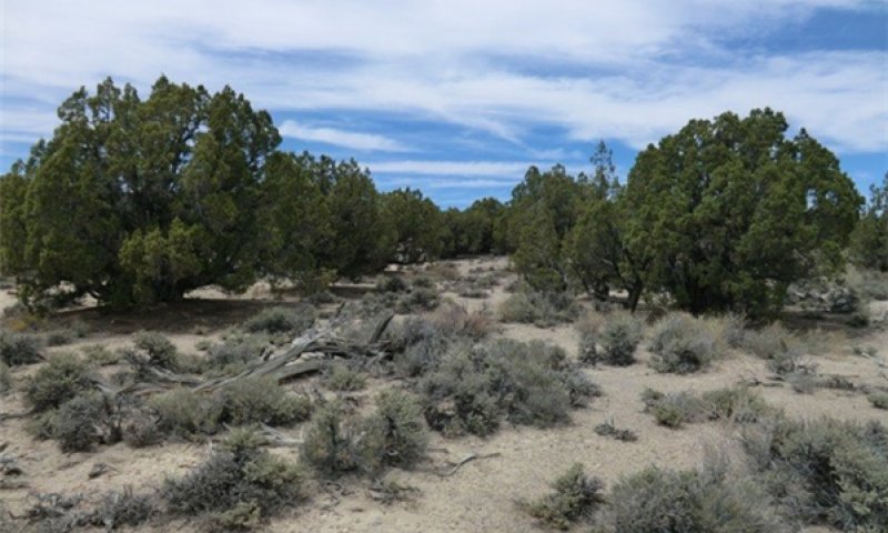
Figure 8. T.Stringham June 2013; NV780, MU1240
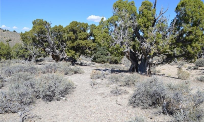
Figure 9. T.Stringham September 2014; NV 779, MU 3143
This phase is characterized by a widely dispersed old-growth Utah juniper trees with a black sagebrush perennial bunchgrass understory. The visual aspect is dominated by Utah juniper which make up 10 to 20 percent of the overstory canopy cover. Trees have reached maximal or near maximal heights for the site and many tree crowns may be flat- or round-topped. Needleandthread and Indian ricegrass are the most prevalent grasses in the understory. Black sagebrush is the primary understory shrub. Forbs such as goldenweed, buckwheat, phlox, and Indian paintbrush are minor components. Overall, the understory is sparse with production ranging between 125 to 300 pounds per acre. Annual non-native species are present in trace amounts.
Forest overstory. OLD GROWTH: The visual aspect and vegetal structure are dominated by Utah juniper that have reached or are near maximal heights for the site. Dominant trees average greater than five inches in diameter at one-foot stump height. Upper crowns of Utah juniper are typically either irregularly or smoothly flat-topped or rounded. Tree canopy cover ranges from 10 to 20 percent.
Forest understory. Understory vegetative composition is about 35 percent grasses, 15 percent forbs and 50 percent shrubs and young trees when the average overstory canopy is medium (10 to 20 percent). Average understory production ranges from 125 to 300 pounds per acre with a medium canopy cover. Understory production includes the total annual production of all species within 4.5 feet of the ground surface.
Understory vegetation is strongly influenced by tree competition, overstory shading, duff accumulation, etc. Infrequent, yet periodic wildfire is a natural factor influencing the understory of mature Utah juniper woodlands. Few seedlings and/or saplings of Utah juniper occur in the understory.
Community 2.2
Herbaceous
This community phase is characterized by a post-fire shrub and herbaceous community. Indian ricegrass, needleandthread and other perennial grasses dominate. Forbs may increase post-fire but will likely return to pre-burn levels within a few years. Utah juniper seedlings up to 20 inches in height may be present. Black sagebrush may be present in unburned patches. Burned tree skeletons may be present; however these have little or no effect on the understory vegetation. Annual non-native species generally respond well after fire and may be stable or increasing within the community.
Forest overstory. Various amounts of tree seedlings and saplings occur in the overstory. Canopy cover is 10 percent or less.
Forest understory. Herbaceous vegetation and woody shrubs dominate the site. Understory production ranges from 200 to 500 pounds per acre.
Community 2.3
Immature woodland
This community phase is characterized by an immature woodland, with Utah juniper trees averaging over 4.5 feet in height. Tree canopy cover is between 10 to 20 percent. Tree crowns are typically cone- or pyramidal-shaped. Understory vegetation consists of smaller tree seedling and saplings, as well as perennial bunchgrasses and shrubs. Annual non-native species are present.
Forest overstory. The visual aspect and vegetal structure are dominated by Utah juniper. Seedlings and saplings are present in the understory. Canopy cover is less than 20 percent.
Forest understory. Understory production ranges from 200 to 500 pounds per acre. Understory vegetation is moderately influenced by a tree overstory canopy of 10 to 20 percent.
Community 2.4
Infilled trees (At Risk)
This phase is dominated by Utah juniper. The stand exhibits mixed age classes and canopy cover exceeds 20 percent. The density and vigor of the black sagebrush and perennial bunchgrass understory is decreased. Bare ground areas are likely to increase. Mat-forming forbs may increase. Annual non-native species are present primarily under tree canopies. This community is at risk of crossing a threshold, without proper management this phase will transition to the infilled tree state 3.0. This community phase is typically described as early Phase II woodland (Miller et al. 2008).
Forest overstory. The visual aspect and vegetal structure are dominated by Utah juniper that have reached or are near maximal heights for the site. Dominant trees average greater than five inches in diameter at one-foot stump height. Upper crowns of Utah juniper are typically either irregularly or smoothly flat-topped or rounded. Tree canopy cover is greater than 20 percent. Understory vegetation is strongly influenced by tree competition, overstory shading, duff accumulation, etc. Infrequent, yet periodic wildfire is a natural factor influencing the understory of mature Utah juniper forestlands. Few seedlings and/or saplings of Utah juniper occur in the understory.
Forest understory. Understory vegetative composition is about 35 percent grasses, 15 percent forbs and 50 percent shrubs and young trees when the average overstory canopy is greater than 20 percent. Average understory production ranges from 75 to 125 pounds per acre. Understory production includes the total annual production of all species within 4.5 feet of the ground surface.
Pathway 2.1a
Community 2.1 to 2.2
A high-severity crown fire will eliminate or reduce the Utah juniper overstory and the shrub component. This allows for the perennial bunchgrasses to dominate the site.
Pathway 2.1b
Community 2.1 to 2.4
Time without disturbance such as fire, drought, or disease will allow for the gradual infilling of Utah juniper.
Pathway 2.2a
Community 2.2 to 2.3
Time without disturbance such as fire, drought, or disease will allow for the gradual maturation of the Utah Juniper component. Black sagebrush and other shrubs reestablish.
Pathway 2.3b
Community 2.3 to 2.2
Fire reduces or eliminates tree canopy, allowing perennial grasses and sprouting shrubs to dominate the site.
Pathway 2.3a
Community 2.3 to 2.4
Time without disturbance such as fire, drought, or disease will allow for the gradual maturation of Utah juniper. Infilling by younger trees continues.
Pathway 2.4a
Community 2.4 to 2.1
Low intensity fire, insect infestation, or disease kills individual trees within the stand reducing canopy cover to less than 20 percent. Over time young trees mature to replace and maintain the old-growth woodland. The black sagebrush and perennial bunchgrass community increases in density and vigor. Annual non-natives present in trace amounts.
Pathway 2.4b
Community 2.4 to 2.2
A high-severity crown fire will eliminate or reduce the Utah juniper overstory and the shrub component which will allow for the perennial bunchgrasses to dominate the site. Annual non-native grasses typically respond positively to fire and may increase in the post-fire community.
State 3
Infilled Tree State
This state has two community phases and is identified by 30 to 50 percent cover of Utah juniper. Trees are at maximal height and upper crowns may be flat-topped or rounded. Understory vegetation is sparse due to increasing shade and competition from trees.
Community 3.1
Utah Juniper/sparse understory
Utah juniper dominates the aspect. Understory vegetation is thinning. Perennial bunchgrasses are sparse and black sagebrush skeletons are as common as live shrubs due to tree competition for soil water, overstory shading, and duff accumulation. Tree canopy cover is greater than 30 percent. Annual non-native species are present or co-dominate in the understory. Bare ground areas are prevalent. This community phase is typically described as a Phase II woodland (Miller et al. 2008).
Forest overstory. The visual aspect and vegetal structure are dominated by Utah juniper that have reached or are near maximal heights for the site. Dominant trees average greater than five inches in diameter at one-foot stump height. Upper crowns of Utah juniper are typically either irregularly or smoothly flat-topped or rounded. Tree canopy cover is greater than 30 percent.
Forest understory. Average understory production is less than 150 pounds/acre. Understory production includes the total annual production of all species within 4.5 feet of the ground surface.
Understory vegetation is strongly influenced by tree competition, overstory shading, duff accumulation, etc. Infrequent, yet periodic wildfire is a natural factor influencing the understory of mature Utah juniper woodlands.
Community 3.2
Utah Juniper
Utah juniper dominates the aspect. Tree canopy cover exceeds 50 percent. Understory vegetation is sparse to absent. Perennial bunchgrasses, if present exist in the dripline or under the canopy of trees. Black sagebrush skeletons are common or the sagebrush has been extinct long enough that only scattered limbs remain. Mat-forming forbs or Sandberg’s bluegrass may dominate interspaces. Annual non-native species are present and are typically found under the trees. Bare ground areas are large and interconnected. Soil redistribution may be extensive. This community phase is typically described as a Phase III woodland (Miller et al. 2008). Trees are dominant vegetation and influencing ecological processes on the site. There is limited tree recruitment.
Forest overstory. Dominant trees average greater than five inches in diameter at one-foot stump height. Upper crowns of Utah juniper are typically either irregularly or smoothly flat-topped or rounded. Tree canopy cover is greater than 50 percent.
Forest understory. Average understory production is less than 100 pounds per acre. Understory production includes the total annual production of all species within 4.5 feet of the ground surface.
Understory vegetation is strongly influenced by tree competition, overstory shading, duff accumulation, etc.
Pathway 3.1a
Community 3.1 to 3.2
Time without disturbance such as fire, drought, or disease will allow for the gradual maturation Utah juniper. Infilling by younger trees continues.
State 4
Eroded State
This site has one community phase. Abiotic factors including soil redistribution and erosion, excessive soil temperature, soil crusting and sealing are primary drivers of ecological condition within this state. Soil moisture, soil nutrients and soil organic matter distribution and cycling are severely altered due to degraded soil surface conditions. Utah juniper dominates the overstory and herbaceous species may be present in trace amount particularly under tree canopies. Recruitment of trees or herbaceous species is limited.
Community 4.1
Eroded Phase
Soil erosion is driving site dynamics. Utah juniper and other species may still be present on the site, but are reduced in density and not controlling site processes. Recruitment of trees or herbaceous species is limited. Site function is controlled by soil erosion, wind and excessive soil temperatures.
Forest overstory. Dominant and codominant trees average greater than five inches in diameter at one-foot stump height. Upper crowns are typically irregularly flat-topped or rounded.
Forest understory. Average understory production is less than 150 pounds per acre. Understory production includes the total annual production of all species within 4.5 feet of the ground surface.
Transition T1A
State 1 to 2
Trigger: Introduction of non-native annual species. Slow variables: Over time the annual non-native plants will increase within the community. Threshold: Any amount of introduced non-native species causes an immediate decrease in the resilience of the site. Annual non-native species cannot be easily removed from the system and have the potential to significantly alter disturbance regimes from their historic range of variation.
Transition T1B
State 1 to 3
Trigger: Time and a lack of disturbance allow trees to dominate site resources; may be coupled with inappropriate herbivory that favors shrub and tree dominance. Slow variables: Over time the abundance and size of trees will increase. Threshold: Juniper canopy cover is greater than 30 percent. Little understory vegetation remains due to competition with trees for site resources.
Transition T2A
State 2 to 3
Trigger: Time and a lack of disturbance allow trees to dominate site resources; may be coupled with inappropriate grazing management that favors shrub and tree dominance. Slow variables: Over time the abundance and size of trees will increase. Threshold: Utah juniper canopy cover is greater than 30 percent. Little understory vegetation remains due to competition with trees for site resources.
Restoration pathway R3A
State 3 to 2
Manual or mechanical thinning of trees coupled with seeding. Probability of success is highest from community phase 3.1.
Conservation practices
| Brush Management | |
|---|---|
| Range Planting |
Transition T3A
State 3 to 4
Trigger: Time allows for an increase in tree canopy cover and greatly reduces cover of all understory species. Bare ground greatly increases, allowing for soil movement. Slow variables: Increasing water and wind erosion coupled with lack of cover changes site soil properties: temperature, infiltration rates, and levels of organic matter no longer support reference vegetation. Threshold: Soil redistribution and erosion is significant and linked to vegetation mortality evidenced by pedestalling and burying of herbaceous species and / or lack of recruitment in the interspaces.
Additional community tables
Table 7. Community 1.1 plant community composition
| Group | Common name | Symbol | Scientific name | Annual production (lb/acre) | Foliar cover (%) | |
|---|---|---|---|---|---|---|
|
Grass/Grasslike
|
||||||
| 1 | Primary Perennial Grasses | 60–132 | ||||
| Indian ricegrass | ACHY | Achnatherum hymenoides | 20–48 | – | ||
| needle and thread | HECO26 | Hesperostipa comata | 20–48 | – | ||
| bluegrass | POA | Poa | 10–18 | – | ||
| squirreltail | ELEL5 | Elymus elymoides | 10–18 | – | ||
| 2 | Secondary Perennial Grasses | 2–10 | ||||
| basin wildrye | LECI4 | Leymus cinereus | 2–10 | – | ||
|
Forb
|
||||||
| 3 | Perennial | 6–15 | ||||
| matted buckwheat | ERCA8 | Eriogonum caespitosum | 2–10 | – | ||
| spiny phlox | PHHO | Phlox hoodii | 2–10 | – | ||
| stemless mock goldenweed | STAC | Stenotus acaulis | 2–10 | – | ||
| thickstem wild cabbage | CACR11 | Caulanthus crassicaulis | 2–10 | – | ||
| castilla | CASTI | Castilla | 2–5 | – | ||
| rockcress | ARABI | Arabidopsis | 2–5 | – | ||
| milkvetch | ASTRA | Astragalus | 2–5 | – | ||
| cryptantha | CRYPT | Cryptantha | 1–3 | – | ||
|
Shrub/Vine
|
||||||
| 4 | Primary Shrubs | 50–100 | ||||
| black sagebrush | ARNO4 | Artemisia nova | 50–100 | – | ||
| 5 | Secondary Shrubs | 2–10 | ||||
| antelope bitterbrush | PUTR2 | Purshia tridentata | 2–10 | – | ||
| desert snowberry | SYLO | Symphoricarpos longiflorus | 2–10 | – | ||
| yellow rabbitbrush | CHVI8 | Chrysothamnus viscidiflorus | 2–10 | – | ||
| Nevada jointfir | EPNE | Ephedra nevadensis | 2–10 | – | ||
| slender buckwheat | ERMI4 | Eriogonum microthecum | 2–5 | – | ||
| shadscale saltbush | ATCO | Atriplex confertifolia | 2–5 | – | ||
|
Tree
|
||||||
| 6 | Evergreen | 20–51 | ||||
| Utah juniper | JUOS | Juniperus osteosperma | 20–48 | – | ||
| singleleaf pinyon | PIMO | Pinus monophylla | 0–10 | – | ||
Interpretations
Animal community
Livestock Interpretations:
The history of livestock grazing in the pinyon-juniper ecosystem goes back to more than 200 years, depending on the particular locality within the ecosystem (Hurst 1975). Historically, pinyon-juniper woodlands were much more open and supported a diverse understory that provided forage for both livestock and wildlife. Historic livestock overuse and increased stand densities have reduced the carrying capacity of these pinyon-juniper stands and many current stands only provide shade and shelter for livestock.
Black sagebrush palatability has been rated as moderate to high depending on the ungulate and the season of use (Horton 1989, Wambolt 1996). The palatability of black sagebrush increase the potential negative impacts on remaining black sagebrush plants from grazing or browsing pressure following fire (Wambolt 1996). Pronghorn utilize black sagebrush heavily (Beale and Smith 1970). On the Desert Experiment Range, black sagebrush was found to comprise 68% of pronghorn diet even though it was only the 3rd most common plant. Fawns were found to prefer black sagebrush utilizing it more than all other forage species combined (Beale and Smith 1970). Domestic livestock will also utilize black sagebrush. The domestic sheep industry that emerged in the Great Basin in the early 1900s was largely based on wintering domestic sheep in black sagebrush communities (Mozingo 1987). Domestic sheep will browse black sagebrush during all seasons of the year depending on the availability of other forage species with greater amounts being consumed in fall and winter. Black sagebrush is generally less palatable to cattle than to domestic sheep and wild ungulates (McArthur et al. 1982); however, cattle use of black sagebrush has also been shown to be greatest in fall and winter (Schultz and McAdoo 2002), with only trace amounts being consumed in summer (Van Vuren 1984).
Inappropriate grazing management during the growing season will cause a decline in understory plants such as Indian ricegrass and needleandthread. Indian ricegrass is a preferred forage species for livestock and wildlife (Cook 1962, Booth et al. 2006). This species is often heavily utilized in winter because it cures well (Booth et al. 2006). It is also readily utilized in early spring, being a source of green feed before most other perennial grasses have produced new growth (Quinones 1981). Booth et al. (2006) note that the plant does well when utilized in winter and spring. Cook and Child (1971) however, found that repeated heavy grazing reduced crown cover, which may reduce seed production, density, and basal area of these plants. Additionally, heavy early spring grazing reduces plant vigor and stand density (Stubbendieck 1985). In eastern Idaho, productivity of Indian ricegrass was at least 10 times greater in undisturbed plots than in heavily grazed ones (Pearson 1965). Cook and Child (1971) found significant reduction in plant cover after seven years of rest from heavy (90%) and moderate (60%) spring use. The seed crop may be reduced where grazing is heavy (Bich et al. 1995). Tolerance to grazing increases after May, thus spring deferment may be necessary for stand enhancement (Pearson 1964, Cook and Child 1971); however, utilization of less than 60% is recommended.
Reduced bunchgrass vigor or density provides an opportunity for Sandberg bluegrass, mat forming forbs and/or cheatgrass and other invasive species to occupy interspaces. Sandberg bluegrass increases under grazing pressure (Tisdale and Hironaka 1981) and is capable of co-existing with cheatgrass. Excessive sheep grazing favors Sandberg bluegrass; however, where cattle are the dominant grazers, cheatgrass often dominates (Daubenmire 1970). Thus, depending on the season of use, the grazer and site conditions, either Sandberg bluegrass or cheatgrass may become the dominant understory with inappropriate grazing management. Field surveys indicate native, mat-forming forbs may also increase with decreased bunchgrass density.
Wildlife Interpretations
Pinyon-juniper woodlands provide a diversity of habitat for wildlife. Although the foliage of pinyon and juniper varies in palatability among fauna, the pinyon nuts and juniper berries are preferred by many species. The understory species provide fruits and browse for large ungulates, small mammals, birds and beaver (Wildlife Action Plan Team 2012).
Ungulates will use pinyon and juniper trees for cover and graze the foliage. The understory species also provide critical browse for deer. The trees provide important cover for mule deer (Odocoileus heminous), elk (Cervus canadensis) wild horses, mountain lion (Puma concolor), bobcat (Lynx rufus) and pronghorn (Antilocapra americana) (Gottfried and Severson 1994, Coates and Schemnitz 1994, Logan and Irwin 1985, Evans 1988).
Mule deer is considered the dominant big game species in the pinyon-juniper woodland and depend heavily on these woodlands for cover, shelter, and emergency forage during severe winters (Frischknecht 1975). Mule deer will eat singleleaf pinyon and juniper foliage, using the foliage moderately in winter, spring, and summer (Kufeld et al. 1973). Deep snows in higher elevation forest zones force mule deer and elk down into pinyon-juniper habitats during winter. This change in habitat allows mule deer and elk to browse the dwarf trees and shrubs (Gottfried and Severson 1994).
The diet of pronghorn antelope varies considerably; however, singleleaf pinyon was shown to comprise 1 to 2 percent of winter diet of pronghorn antelope that occur in pinyon-juniper habitat. Desert bighorn sheep (Ovis nelson) may utilize pinyon-juniper habitat, but only where the terrain is rocky and steep (Gottfried et al. 2000). Gray foxes, bobcats (Lynx rufus), coyotes (Canis latrans), weasels (Mustela frenata), skunks (Mephitis spp.), badgers (Taxidea taxus), and ringtail cats (Bassariscus astutus) search for prey in pinyon-juniper habitat woodlands (Short and McCulloch 1977).
Juniper "berries" or berry-cones are eaten by black-tailed jackrabbits, Lepus californicus, and coyotes (Gese et al. 1988, Kitchen et al. 2000). A study by Kitchen et al (1999) conducted in juniper-pinyon habitat found vegetation in coyote scats was mainly grass seeds or juniper berries. Jackrabbits are a major dispenser of juniper seeds (Schupp et al. 1999). The pinyon mouse (Peromyscus truei) is a pinyon-juniper obligate and uses the woodlands for cover and food (Hoffmeister 1981). Other small mammals include the porcupine (Hystricomorph hystricidae), desert cottontail (Sylvilagus audubonii), Nuttall’s cottontail (S. nuttallii), deer mouse (Peromyscus maniculatus), Great Basin pocket mouse (Perognathus parvus), chisel-toothed kangaroo rat (Dipodomys microps) and desert woodrat (Neotoma lepida) (Turkowski and Watkins 1976).
Many bird species are associated with the pinyon-juniper habitat; some are permanent residents, some summer residents, and some winter residents, depending upon location. For birds and bats, the woodland provides structure for nesting and roosting, and locations for foraging. Singleleaf pinyon provides a number of cavities and the stringy, fibrous bark provides quality nesting material as well as the food provided by the tree’s seeds and berries (Short and McCulloch 1977). Many bird species depend on juniper berry-cones and pine nuts for fall and winter food (Balda and Masters 1980). Several bird species are obligates including (gray flycatcher (Epidonax wrightii) scrub jay (Aphelocoma californica), plain titmouse (Parus inornatus ridgwayi), and gray vireo (Vireo vicinior) and several species are semi-obligates including black-chinned hummingbird (Archilochus alexandri), ash-throated flycatcher (Myiarchus cinerascens), pinion jay (Gymnorhinus cyanocephalus), American bushtit (Psaltriparus minimus), Bewick’s wren (Thryomanes bewickii), Northern mockingbird (Mimus polyglottos), blue-gray gnatcatcher (Polioptila caerulea), black-throated gray warbler (Dendroica nigrescens), house finch (Haemorhous mexicanus), spotted towhee (Pipilo maculatus), lark sparrow (Chondestes grammacus) and black-chinned sparrow (Zonotrichia atricapilla) (Balda and Masters 1980). Ferruginous hawk (Buteo regalis), a conservation priority species due to recent population declines in Nevada, nest in older trees of sufficient size and structure to support their large nest platforms. (Holechek 1981).
Diurnal reptiles include the sagebrush swift (Sceloporus graciosus), the blue-bellied lizard (Sceloporus elongates) the western collard lizard, the Great Basin rattlesnake, the Great Basin gopher snake (Pituophis catenifer) and horned lizard, also occur in Utah juniper habitat (Frischknecht 1975). However, the distribution of most of herpetofauna present in pinyon-juniper woodlands is poorly understood and more research and management are needed.
Hydrological functions
Runoff is medium to very high. Permeability is slow to moderate. Hydrologic soil group is D. Hydrologic processes are influenced by species composition, structural development and density patterns of the tree overstories and the nature of precipitation events occurring. Interception of precipitation is related to the composition, distribution, and density of trees in the overstory and intensity, duration, and type of precipitation. Infiltration rates are typically greater beneath tree overstories than on sites supporting herbaceous plants because the trees reduce the raindrop impact. The litter accumulation beneath the trees also slows overland flows. Evapotranspiration is generally the largest route of water outflow from the site (Ffolliott and Gottfried. 2012).
Recreational uses
The trees on this site provide a welcome break in an otherwise open landscape. It has potential for hiking, camping and deer and upland game bird hunting. Off-road vehicles can destroy the fragile soil-vegetation complex causing severe erosion problems.
Wood products
Utah juniper wood is very durable. Its primary uses have been for posts and fuelwood. It probably has considerable potential in the charcoal industry and possibly in wood fiber products.
PRODUCTIVE CAPACITY
This site is of very low site quality for tree production. Site index ranges from about 15 to 25 (Howell, 1946).
Productivity Class: 1
CMAI*: <1.3 to 1.7 cu ft/ac/yr;
0.09 to 0.12 cu m/hr/yr.
Culmination is estimated to be at 100 years.
*CMAI: is the culmination of mean annual increment or highest average growth rate of the stand in the units specified.
Fuelwood Production: 2 to 4 cords per acre for stands averaging 5 inches in diameter at 1 foot height. There are about 274,000 gross British Thermal Units (BTUs) heat content per cubic foot of Utah juniper. Firewood is commonly measured by the cord, or a stacked unit equivalent to 128 cubic feet. Solid wood volume in a cord varies but usually ranges from 65 to 90 cubic feet. Assuming an average of 75 cubic feet of solid wood per cord, there are about 20 million BTUs of heat value in a cord of Utah juniper.
Posts (7 foot): 10 to 20 per acre in stands of medium canopy.
MANAGEMENT GUIDES AND INTERPRETATIONS
1. LIMITATIONS AND CONSIDERATIONS
a. Potential for sheet and rill erosion is moderate to severe depending on slope.
b. Moderate to severe equipment limitations on steeper slopes and on sites having extreme surface stoniness.
c. Proper spacing is the key to a well managed, multiple use and multi-product Utah juniper woodland.
2. ESSENTIAL REQUIREMENTS
a. Adequately protect from uncontrolled burning.
b. Protect soils from accelerated erosion.
c. Apply proper grazing management practices.
3. SILVICULTURAL PRACTICES
Due to the low production of this site, silvicultural practices are not addressed.
Other products
Indian ricegrass was traditionally eaten by some Native American peoples. The Paiutes used the seed as a reserve food source. Juniper berries were eaten by Native Americans.
Other information
Indian ricegrass is well-suited for surface erosion control and desert revegetation although it is not highly effective in controlling sand movement. Needleandthread is useful for stabilizing eroded or degraded sites.
Table 8. Representative site productivity
| Common name | Symbol | Site index low | Site index high | CMAI low | CMAI high | Age of CMAI | Site index curve code | Site index curve basis | Citation |
|---|---|---|---|---|---|---|---|---|---|
| Utah juniper | JUOS | 15 | 25 | 1 | 2 | – | – | – |
Supporting information
Inventory data references
NASIS soil component data.
Type locality
| Location 1: White Pine County, NV | |
|---|---|
| Township/Range/Section | T14N R61E S28 |
| Latitude | 39° 2′ 55″ |
| Longitude | 115° 7′ 34″ |
| General legal description | Sierra Valley, South of Ely, Nevada, White Pine Co., Nevada. |
Other references
Anderson, E. W. and R. J. Scherzinger. 1975. Improving quality of winter forage for elk by cattle grazing. Journal of Range Management:120-125.
Beale, D. M. and A. D. Smith. 1970. Forage Use, Water Consumption, and Productivity of Pronghorn Antelope in Western Utah. The Journal of Wildlife Management 34:570-582.
Beetle, A. A. 1960. A study of sagebrush. The section Tridentatae of Artemisia. Bull. Wyo. agric. Exp. Stn. 368:83 pp.
Bich, B. S., J. L. Butler, and C. A. Schmidt. 1995. Effects of Differential Livestock Use on Key Plant Species and Rodent Populations within Selected Oryzopsis hymenoides/Hilaria jamesii Communities of Glen Canyon National Recreation Area. The Southwestern Naturalist 40:281-287.
Blaisdell, J. P. and J. F. Pechanec. 1949. Effects of Herbage Removal at Various Dates on Vigor of Bluebunch Wheatgrass and Arrowleaf Balsamroot. Ecology 30:298-305.
Boltz, M. 1994. Factors influencing postfire sagebrush regeneration in south-central Idaho. Pages 281-290 in Proceedings -- ecology and mangement of annual rangelands. Gen. Tech. Rep. INT-GTR-313. U.S. Department of Agriculture, Forest Service, Intermountain Research Station, Boise, ID.
Booth, D. T., C. G. Howard, and C. E. Mowry. 2006. 'Nezpar' Indian ricegrass: description, justification for release, and recommendations for use. Rangelands Archives 2:53-54.
Bradley, A. F., N. V. Noste, and W. C. Fischer. 1992. Gen. Tech. Rep. INT-287: Fire ecology of forests and woodlands in Utah. . U.S. Department of Agriculture, Forest Service, Intermountain Research Station, Ogden, UT.
Britton, C. M., G. R. McPherson, and F. A. Sneva. 1990. Effects of burning and clipping on five bunchgrasses in eastern Oregon. Great Basin Naturalist 50:115-120.
Bunting, S. 1994. Effects of Fire on Juniper woodland ecosystems in the great basin.in Proceedings--Ecology and Management of Annual Rangelands. USDA: FS Intermountain Research Station.
Busso, C. A. and J. H. Richards. 1995. Drought and clipping effects on tiller demography andgrowth of two tussock grasses in Utah. Journal of Arid Environments 29:239-251.
Caudle, D., J. DiBenedetto, M. Karl, H. Sanchez, and C. Talbot. 2013. Interagency ecological site handbook for rangelands. Available at: http://jornada.nmsu.edu/sites/jornada.nmsu.edu/files/InteragencyEcolSiteHandbook.pdf. Accessed 4 October 2013.
Chambers, J. C., B. A. Bradley, C. S. Brown, C. D’Antonio, M. J. Germino, J. B. Grace, S. P. Hardegree, R. F. Miller, and D. A. Pyke. 2013. Resilience to stress and disturbance, and resistance to Bromus tectorum L. invasion in cold desert shrublands of western North America. Ecosystems:1-16.
Chambers, J.C., E.W. Schupp and S.B. Vander Wall. 1999. Seed dispersal and seedling establishment of pinyon and juniper species within the pinon-juniper woodland. IN: Proceedings: ecology and management of pinyon–juniper communities within the Interior West. Ogden, UT, USA: US Department of Agriculture, Forest Service, Rocky Mountain Research Station, RMRS-P-9:29-34.
Christopherson, J. 2014. Dwarf Mistletoe (Arceuthobium spp.). Nevada Division of Forestry, 2478 Fairview Drive, Carson City Nevada.
Conrad, C. E. and C. E. Poulton. 1966. Effect of a wildfire on Idaho fescue and bluebunch wheatgrass. Journal of Range Management:138-141.
Cook, C. W. 1962. An Evaluation of Some Common Factors Affecting Utilization of Desert Range Species. Journal of Range Management 15:333-338.
Cook, C. W. and R. D. Child. 1971. Recovery of Desert Plants in Various States of Vigor. Journal of Range Management 24:339-343.
Daubenmire, R. 1970. Steppe vegetation of Washington. 131 pp.
Daubenmire, R. 1975. Plant succession on abandoned fields, and fire influences in a steppe area in southeastern Washington. Northwest Science 49:36-48.
Durham, G. 2014. Juniper Pocket Rot (Pyrofomes demidoffii.). Nevada Division of Forestry, 2478 Fairview Drive, Carson City, Nevada 89701.
Fire Effects Information System (Online; http://www.fs.fed.us/database/feis/plants/).
Ffolliott, P.F. and G.J. Gottfried. 2012. Hydrologic processes in the pinyon-juniper woodlands: A literature review. Gen. Tech. Rep. RMRS-GTR-271. Fort Collins, CO. U.S. Department of Agriculture, Forest Service, Rocky Mountain Research Station. 20 p.
Gruell, G.E. 1999. Historical and modern roles of fire in pinyon-juniper. In:Proceedings: ecology and management of pinyon–juniper communities within the Interior West. Ogden, UT, USA: US Department of Agriculture, Forest Service, Rocky Mountain Research Station, RMRS-P-9:35-46.
Heyerdahl, E.K., Miller, R.F, and Parsons, R.A. 2006. History of fire and Douglas-fir establishment in a savanna and sagebrush grassland mosaic, southwestern Montana, USA. Forest Ecology and Management. 230:107-118.
Holmes, R.L., R.K., Adams, H.C. Fritts. 1986. Tree ring chronologies of western North America: California, eastern Oregon and northern Great Basin. Chronology Series VI. Laboratory of Tree Ring Research, University of Arizona, Tucson, AZ 183p.
Horton, H. 1989. Interagency forage and conservation planting guide for Utah. Extension circular 433. Utah State University, Utah Cooperative Extension Service, Logan UT.
Howell, J. 1940. Pinyon and juniper: a preliminary study of volume, growth, and yield. Regional Bulletin 71. Albuquerque, NM: USDA, NRCS; 90p.
Houghton, J.G., C.M. Sakamoto, and R.O. Gifford. 1975. Nevada’s Weather and Climate, Special Publication 2. Nevada Bureau of Mines and Geology, Mackay School of Mines, University of Nevada, Reno, NV.
Huber, A., S. Goodrich, K. Anderson. 1999. Diversity with successional status in the pinyon-juniper/mountain mahogany/bluebunch wheatgrass community type Near Dutch John, Utah. US Department of Agriculture, Forest Service, Rocky Mountain Research Station Proceedings RMRSP-9.
Kitchen, S. G. and E. D. McArthur. 2007. Big and black sagebrush landscapes. Pages 73-95 in Fire ecology and mangement of the major ecosystems of southern Utah. Gen. Teck. Rep. RMRMS-GTR-202. U.S. Department of Agriculture, Forest Service, Rocky Mountain Research Station, Fort Collins, CO.
Koniak, S. 1985. Succession in pinyon-juniper woodlands following wildfire in the Great Basin. The Great Basin Naturalist 45:556-566.
Laycock, W. A. 1967. How heavy grazing and protection affect sagebrush-grass ranges. Journal of Range Management:206-213.
McArthur, E. D., A. Blaner, A. P. Plummer, and R. Stevens. 1982. Characteristics and hybridization of important Intermountain shrubs: 3. Sunflower family. En Ref. in Forest. Abstr 43:2176.
Meewig, R.O. and R.L. Bassett. 1983. Pinyon-juniper. In:Silvicultural Systems for the Major Forest Types of the United States. Agric. Handbook. 455, Washington, D.C.: USDA:84-86.
Meyer, S. E. 2008. Artemisia L. -- sagebrush. Pages 274-280 in F. T. Bonner and R. P. Karrfalt, editors. The woody plant seed manual. Agriculture Handbook 727. U.S. Department of Agriculture, Forest Service, Washington, DC.
Miller, R.F. and T.J. Rose. 1995. Historic expansion of Juniperus occidentalis (western juniper) in southeastern Oregon. Great Basin Naturalist. 55:37-45.
Miller, R.F. and T.J. Rose. 1999. Fire history and western juniper encroachment in sagebrush steppe. Journal of Range Management.52:550-559.
Miller, R.F. R.J. Tausch and W. Waichler. 1999. Old-growth juniper and pinyon woodlands. In: Monsen, S.D. and R. Stevens. Comps. Proceedings: Ecology and Management of Pinyon-Juniper communities within the interior West; 1997 September 15-18; Provo, UT. USDA, Forest Service RMRS-P-9: 375-384 Logan Ut.
Miller, R.F. and R.J. Tausch. 2001. The role of fire in pinyon and juniper woodlands: a descriptive analysis. In: Galley, K.E.M., Wilson, T.P. eds. Invasive Species: the role of fire in the control and spread of invasive species symposium. Miscellaneous Publication No. 11, Tall Timbers Research Station, Tallahassee, FL. 15-30.
Miller, R.F. R.J. Tasuch, E.D. McArthur, D.D. Johnson and S.C. Sanderson. 2008. Age Structure and Expansion of Pinon-Juniper Woodlands: A Regional Perspective in the Inter-Mountain West. USDA Forest Service RMRS-RP-69. pp. 1-13.
Mozingo, H. N. 1987. Shrubs of the Great Basin: A natural history. University of Nevada Press, Reno NV.
Mueggler, W. F. 1975. Rate and Pattern of Vigor Recovery in Idaho Fescue and Bluebunch Wheatgrass. Journal of Range Management 28:198-204.
National Oceanic and Atmospheric Administration. 2004. The North American Monsoon. Reports to the Nation. National Weather Service, Climate Prediction Center. Available online: http://www.weather.gov/
Pearson, L. 1964. Effect of harvest date on recovery of range grasses and shrubs. Agronomy Journal 56:80-82.
Pearson, L. C. 1965. Primary Production in Grazed and Ungrazed Desert Communities of Eastern Idaho. Ecology 46:278-285.
Phillips, G. 2014. Pinyon Needle Scales. Nevada Divison of Forestry, 2478 Fairview Drive, Carson City, Nevada.
Quinones, F. A. 1981. Indian ricegrass evaluation and breeding. Bulletin 681. Page 19. New Mexico State University, Agricultural Experiment Station, Las Cruces, NM.
Robberecht, R. and G. Defossé. 1995. The relative sensitivity of two bunchgrass species to fire. International Journal of Wildland Fire 5:127-134.
Schultz, B. W. and J. K. McAdoo. 2002. Common sagebrush in Nevada. Special Publication SP-02-02. University of Nevada, Cooperative Extension, Reno, NV.
Stevens, R., K. R. Jorgensen, and J. N. Davis. 1981. Viability of seed from thirty-two shrub and forb species through fifteen years of warehouse storage. Western North American Naturalist 41:274-277.
Stringham, T.K., P. Novak-Echenique, P. Blackburn, C. Coombs, D. Snyder and A. Wartgow. 2015. Final Report for USDA Ecological Site Description State-and-Transition Models, Major Land Resource Area 28A and 28B Nevada. University of Nevada Reno, Nevada Agricultural Experiment Station Research Report 2015-01. p. 1524.
Stubbendieck, J. L. 1985. Nebraska Range and Pasture Grasses: (including Grass-like Plants). University of Nebraska, Department of Agriculture, Cooperative Extension Service, Lincoln, NE.
Tausch, R. J. 1999. Historic pinyon and juniper woodland development. Proceedings: ecology and management of pinyon–juniper communities within the Interior West. Ogden, UT, USA: US Department of Agriculture, Forest Service, Rocky Mountain Research Station, RMRS-P-9:12-19.
Tausch, R. J. and N. E. West. 1988. Differential establishment of pinyon and juniper following fire. American Midland Naturalist:174-184.
Tisdale, E. W. and M. Hironaka. 1981. The sagebrush-grass region: A review of the ecological literature. University of Idaho, Forest, Wildlife and Range Experiment Station.
Uresk, D. W., J. F. Cline, and W. H. Rickard. 1976. Impact of wildfire on three perennial grasses in south-central Washington. Journal of Range Management 29:309-310.
USDA. 1997. Inventorying, Classifying, and Correlating Juniper and Pinyon Communities to Soils in Western United States. U.S. Department of Agriculture, Natural Resources Conservation Service, Grazing Lands Technology Institute, Fort Worth, TX.
USDA-NRCS Plants Database (Online; http://www.plants.usda.gov).
Vallentine, J. F. 1989. Range development and improvements. Academic Press, Inc.
Van Vuren, D. 1984. Summer Diets of Bison and Cattle in Southern Utah. Journal of Range Management 37:260-261.
Wambolt, C. L. 1996. Mule Deer and Elk Foraging Preference for 4 Sagebrush Taxa. Journal of Range Management 49:499-503.
West, N. E. 1994. Effects of fire on salt-desert shrub rangelands.in Proceedings--Ecology and Management of Annual Rangelands, General Technical Report INT-313. USDA Forest Service, Intermountain Research Station, Boise, ID.
West, N.E. R.J. Tausch and P.T. Tueller. 1998. A management oriented classificaton of pinyon-juniper woodlands in the Great Basin. Gen. Tech. Rep. USDA Forest Service, RMRS-GTR-12. Ogden, UT. pp. 43-52.
Wright, H. A. 1971. Why squirreltail is more tolerant to burning than needle-and-thread. Journal of Range Management 24:277-284.
Wright, H. A. 1985. Effects of fire on grasses and forbs in sagebrush-grass communities. Pages 12-21 in Rangeland Fire Effects; A Symposium: Boise, ID, USDI-BLM.
Wright, H. A., C. M. Britton, and L. F. Neuenschwander. 1979. The role and use of fire in sagebrush-grass and pinyon-juniper plant communities: a state-of-the-art review. Intermountain Forest and Range Experiment Station, Forest Service, US Department of Agriculture.
Young, R. P. 1983. Fire as a vegetation management tool in rangelands of the intermountain region. Pages 18-31 in Managing intermountain rangelands - improvement of range and wildlife habitats. USDA, Forest Service.
Contributors
T Stringham
RK
P NovakEchenique
Approval
Kendra Moseley, 2/19/2025
Rangeland health reference sheet
Interpreting Indicators of Rangeland Health is a qualitative assessment protocol used to determine ecosystem condition based on benchmark characteristics described in the Reference Sheet. A suite of 17 (or more) indicators are typically considered in an assessment. The ecological site(s) representative of an assessment location must be known prior to applying the protocol and must be verified based on soils and climate. Current plant community cannot be used to identify the ecological site.
| Author(s)/participant(s) | |
|---|---|
| Contact for lead author | |
| Date | 02/20/2025 |
| Approved by | Kendra Moseley |
| Approval date | |
| Composition (Indicators 10 and 12) based on | Annual Production |
Indicators
-
Number and extent of rills:
-
Presence of water flow patterns:
-
Number and height of erosional pedestals or terracettes:
-
Bare ground from Ecological Site Description or other studies (rock, litter, lichen, moss, plant canopy are not bare ground):
-
Number of gullies and erosion associated with gullies:
-
Extent of wind scoured, blowouts and/or depositional areas:
-
Amount of litter movement (describe size and distance expected to travel):
-
Soil surface (top few mm) resistance to erosion (stability values are averages - most sites will show a range of values):
-
Soil surface structure and SOM content (include type of structure and A-horizon color and thickness):
-
Effect of community phase composition (relative proportion of different functional groups) and spatial distribution on infiltration and runoff:
-
Presence and thickness of compaction layer (usually none; describe soil profile features which may be mistaken for compaction on this site):
-
Functional/Structural Groups (list in order of descending dominance by above-ground annual-production or live foliar cover using symbols: >>, >, = to indicate much greater than, greater than, and equal to):
Dominant:
Sub-dominant:
Other:
Additional:
-
Amount of plant mortality and decadence (include which functional groups are expected to show mortality or decadence):
-
Average percent litter cover (%) and depth ( in):
-
Expected annual annual-production (this is TOTAL above-ground annual-production, not just forage annual-production):
-
Potential invasive (including noxious) species (native and non-native). List species which BOTH characterize degraded states and have the potential to become a dominant or co-dominant species on the ecological site if their future establishment and growth is not actively controlled by management interventions. Species that become dominant for only one to several years (e.g., short-term response to drought or wildfire) are not invasive plants. Note that unlike other indicators, we are describing what is NOT expected in the reference state for the ecological site:
-
Perennial plant reproductive capability:
Print Options
Sections
Font
Other
The Ecosystem Dynamics Interpretive Tool is an information system framework developed by the USDA-ARS Jornada Experimental Range, USDA Natural Resources Conservation Service, and New Mexico State University.
Click on box and path labels to scroll to the respective text.