Natural Resources
Conservation Service
Ecological site R029XY042NV
COARSE SILTY 5-8 P.Z.
Last updated: 2/20/2025
Accessed: 04/10/2026
General information
Provisional. A provisional ecological site description has undergone quality control and quality assurance review. It contains a working state and transition model and enough information to identify the ecological site.
MLRA notes
Major Land Resource Area (MLRA): 029X–Southern Nevada Basin and Range
The Southern Nevada Basin and Range MLRA (29) represents the transition from the Mojave Desert to the Great Basin. It is cooler and wetter than the Mojave. It is warmer and typically receives more summer precipitation than the Great Basin. This area is in Nevada (73 percent), California (25 percent), and Utah (2 percent). It makes up about 26,295 square miles (68,140 square kilometers). Numerous national forests occur in the area, including the San Bernardino, Angeles, Sequoia, Inyo, Humboldt-Toiyabe, and Dixie National Forests. Portions of Death Valley National Monument, the Nuclear Regulatory Commission’s Nevada Test Site, the Hawthorne Ammunition Depot, and the Nellis Air Force Range in Nevada and the China Lake Naval Weapons Center in California also are in this MLRA. The northeast part of the Paiute Indian Reservation and the southern third of the Walker River Indian Reservation are in the part of this MLRA in Nevada, and the Lone Pine, Fort Independence, and Big Pine Indian Reservations are in the part in California.
Physiography:
The entire area is in the Great Basin Section of the Basin and Range Province of the Intermontane Plateaus. The area of broad, nearly level, aggraded desert basins and valleys between a series of mountain ranges trending north to south. The basins are bordered by sloping fans and pluvial lake terraces. The mountains are uplifted fault blocks with steep side slopes and not well dissected due to limited annual precipitation. Most of the valleys in this MLRA are closed basins or bolsons containing sinks or playa lakes.
Geology:
The mountains are dominated by Pliocene and Miocene andesite and basalt rocks, Paleozoic and Precambrian carbonate rocks prominent in some areas. Scattered outcrops of older Tertiary intrusives and very young tuffaceous sediments (Pliocene and Miocene) are in the western and eastern thirds of this MLRA. The valleys consist mostly of alluvial fill and playa deposits at the lowest elevations in the closed basins.
Climate:
The average annual precipitation is 3 to 12 inches (75 to 305 millimeters) in most of this area. It may be as high as 29 inches (735 millimeters), on the higher mountain slopes. Most of the rainfall occurs as high-intensity, convective thunderstorms during the growing season. Summers are dry, but sporadic storms are common in July and August.
Water Resources:
Water resources are scarce. Ground water and surface water sources are limited. Streams are small and intermittent. Quality of surface water in naturally degraded as streams cross area of valley fill effected by dissolved salts. Irrigation water may raise the levels of dissolved salts and suspended sediments causing contamination.
Soils:
Dominant soil orders include Entisols and Aridisols.
Ecological site concept
The Coarse Silty 5-8 P.Z. site occurs on inset fans, alluvial flats, fan skirts and fan remnants on all exposures. Slopes range from 2 to 15 percent, but slope gradients of 0 to 8 percent are typical. Elevations are 3000 to 7000 feet. The soils are typically very deep and well drained to somewhat excessively drained. Surface soils are typically moderately coarse to coarse textured. The soils are moderately to very strongly alkaline and calcareous throughout the profile.
Associated sites
| R029XY016NV |
LOAMY UPLAND 5-8 P.Z. This site occurs on piedmont slopes, alluvial fans and alluvial plains of all exposures. Slopes range from 0 to 50 percent, but slope gradients of 2 to 15 percent are typical. Elevations are 4200 to about 6000 feet. The soils of this site are moderately deep to deep and well drained. Some soils may have a restrictive layer below the main plant rooting depth. Water intake rates are moderate, available water capacity is very low to moderate, and runoff is medium. |
|---|---|
| R029XY017NV |
LOAMY 5-8 P.Z. This site occurs on piedmont slopes, fan skirts, inset fans, fan remnants and alluvial plains on all exposures. Slopes range from 0 to 30 percent, but slope gradients of 2 to 8 percent are most typical. Elevations are 3100 to 7000 feet. The soils associated with this site are typically very shallow to very deep and well drained. Some soils have a restrictive layer below the main plant rooting depth (at soil depths greater than 14 inches). Surface layers are usually gravelly or very gravelly and have less than 20 percent clay. Surface soils are moderately to strongly alkaline, non-saline to slightly saline, and non-sodic to very slightly sodic. |
| R029XY020NV |
SILTY 5-8 P.Z. This site occurs on alluvial flats, fan skirts, and inset fans on all exposures. Slopes range from 0 to 8 percent, but slope gradients of 0 to 2 percent are typical. Elevations are 3500 to about 7000 feet. The soils are very deep and moderately well drained. Surface soils are typically very fine sandy loams to silt loams. The surface layer of these soils will normally develop a vesicular crust, inhibiting water infiltration and seedling emergence. |
| R029XY046NV |
SANDY LOAM 5-8 P.Z. This site occurs on inset fans and on axial-stream floodplains of basin floors. Slopes range from 0 to 15 percent, but slope gradients of 0 to 8 percent are typical. Elevations are 4400 to about 7000 feet. The soils of this site are typically deep to very deep and well to excessively well drained. These soils have coarse textured surfaces (sandy loams, loamy sands). Water infiltration is moderate to moderately rapid, available water capacity is low. The soils have an ochric epipedon. |
| R029XY059NV |
SHALLOW SILTY 5-8 P.Z. This site occurs on lake plains and lake plain terraces of basin floors. Slopes gradients of 0 to 4 percent are most typical. Elevations are 3500 to about 6500 feet. The soils associated with this site have formed in alluvium over lacustrine deposits derived from mixed rock sources. The soils are very deep and are well drained. Permeability is slow and available water holding capacity is low to moderate. These soils have the potential for formation of gullies, especially in areas near shallow drainageways. |
| R029XY079NV |
DROUGHTY LOAM 5-8 P.Z. This site occurs on inset fans, fan piedmont slopes, and fan skirts. Slope gradients of 0 to 8 percent are typical. Elevations are 4200 to 6000 feet. The soils associated with this site are very shallow to very deep alluvium derived primarily from volcanic rock sources. Soil textures throughout the soil profile are loams to gravelly loams. Some soils may have a restrictive layer below the main plant rooting depth. |
Similar sites
| R029XY059NV |
SHALLOW SILTY 5-8 P.Z. ATCO dominant shrub |
|---|---|
| R029XY046NV |
SANDY LOAM 5-8 P.Z. More productive site; ATCA2-KRLA2 codominant shrubs |
| R029XY017NV |
LOAMY 5-8 P.Z. ATCO dominant shrub |
| R029XY020NV |
SILTY 5-8 P.Z. Less shrub diversity; KRLA2 dominant plant |
Table 1. Dominant plant species
| Tree |
Not specified |
|---|---|
| Shrub |
(1) Krascheninnikovia lanata |
| Herbaceous |
(1) Achnatherum hymenoides |
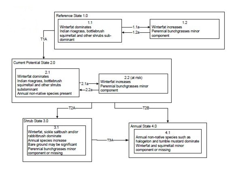
Click on box and path labels to scroll to the respective text.