Natural Resources
Conservation Service
Ecological site DX032X01B176
Very Shallow (VS) Big Horn Basin Rim
Last updated: 10/04/2019
Accessed: 12/19/2025
General information
Provisional. A provisional ecological site description has undergone quality control and quality assurance review. It contains a working state and transition model and enough information to identify the ecological site.

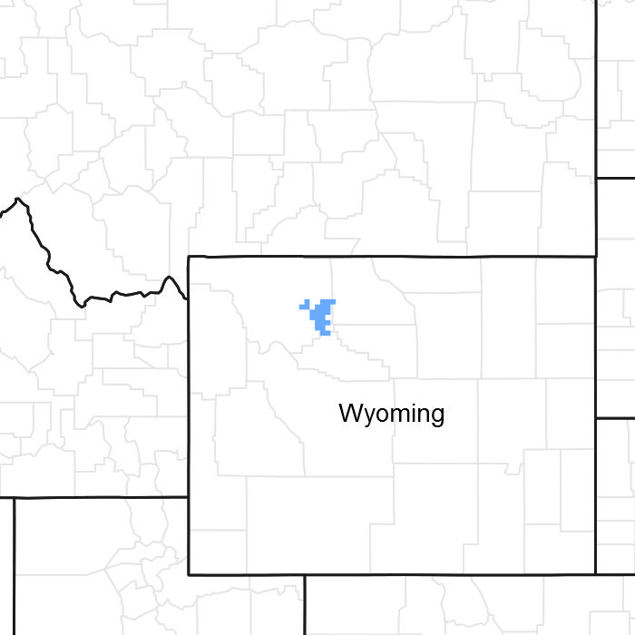
Figure 1. Mapped extent
Areas shown in blue indicate the maximum mapped extent of this ecological site. Other ecological sites likely occur within the highlighted areas. It is also possible for this ecological site to occur outside of highlighted areas if detailed soil survey has not been completed or recently updated.
MLRA notes
Major Land Resource Area (MLRA): 032X–Northern Intermountain Desertic Basins
Major land resource area (MLRA):
032X – Northern Intermountain Desertic Basins – This MLRA is comprised of two major Basins, the Big Horn and Wind River. These two basins are distinctly different and are split by LRU’s to allow individual ESD descriptions. These warm basins are surrounded by uplifts and rimmed by mountains, creating a unique set of plant responses and communities. Unique characteristics of the geology and geomorphology single these two basins out.
Further information regarding MLRAs, refer to: United States Department of Agriculture, Natural Resources Conservation Service. 2006. Land Resource Regions and Major Land Resource Areas of the United States, the Caribbean, and the Pacific Basin. U.S. Department of Agriculture Handbook 296. Available electronically at: http://www.nrcs.usda.gov/wps/portal/nrcs/detail/soils/ref/?cid=nrcs142p2_053624#handbook.
LRU notes
Land Resource Unit (LRU):
32X01B (WY): This LRU is the Big Horn Basin within MLRA 32. This LRU is lower in elevation, slightly warmer and receives slightly less overall precipitation than the Wind River Basin (LRU 02). This LRU was originally divided into two LRU's - LRU A which was the core and LRU B which was the rim. With the most current standards, this LRU is divided into two Subsets. This subset is Subset B, referred to as the Rim, is a transitional band between the basin floor and the lower foothills. The subset encircles Subset A which was originally LRU A. As the LRU shifts towards the south and tracks east, changes in geology and relation to the mountain position, creates a minor shift in soil chemistry influencing the variety of ecological sites and plant interactions. The extent of soils currently correlated to this ecological site does not fit within the digitized boundary. Many of the noted soils are provisional and will be reviewed and corrected in mapping update projects. Other map units are correlated as small inclusions within other MLRA’s/LRU’s based on elevation, landform, and biological references.
Moisture Regime: Ustic Aridic – Prior to 2012, many of the soils within this group were correlated as Frigid Ustic Aridic or as Mesic Typic Aridic, with few mapped within this cross over zone. As progressive soil survey mapping continues, these “crossover” or transitional areas are being identified and corrected.
Temperature Regime: Mesic
Dominant Cover: Rangeland, with Saltbush flats the dominant vegetative cover for this LRU/ESD.
Representative Value (RV) Effective Precipitation: 10-14 inches (254 – 355 mm)
RV Frost-Free Days: 105-125 days
Classification relationships
Relationship to Other Established Classification Systems:
National Vegetation Classification System (NVC):
3 Xeromorphic Woodland, Scrub & Herb Vegetation Class
3.B Cool Semi-Desert Scrub & Grassland Subclass
3.B.1 Cool Semi-Desert Scrub & Grassland formation
3.B.1.NE Western North American Cool Semi-Desert Scrub & Grassland Division
M169 Great Basin & Intermountain Tall Sagebrush Shrubland & Steppe Macrogroup
G302 Artemisia Tridentata - Artemisia tripartita - Purshia tridentata Big Sagebrush Steppe Group
Ecoregions (EPA):
Level I: 10 North American Deserts
Level II: 10.1 Cold Deserts
Level III: 10.1.18 Wyoming Basin
Level IV: 10.1.18.g Big Horn Salt Desert Shrub Basin
Ecological site concept
• Site receives no additional water.
• Slope is < 60%
• Soils are:
o Textures range from loamy sand to clay loam in top 4” (10 cm) of mineral soil surface
o Clay content is ≤ 35% in top 4” (10 cm) of mineral soil surface
o All subsurface horizons have a weighted average of < 35% clay.
o very shallow (< 10 in. (25 cm))
o <3% stone and boulder cover and < 15% cobble and gravel cover
o Generally not skeletal (< 35% rock fragments) but occasionally will have up to 75% gravels and cobbles.
Associated sites
| R032XY362WY |
Shallow Loamy (SwLy) 10-14" East Precipitation Zone Shallow Loamy is commonly located in a complex with very shallow along the scarp face, down slope on the dipslopes of escarpments or hllslopes (ridges) and is associated with inter-bedded sedimentary parent material. |
|---|---|
| R032XY366WY |
Shallow Sandy (SwSy) 10-14" East Precipitation Zone Shallow Sandy is commonly located in a complex with very shallow along the scarp face, down slope on the dipslopes of escarpments or hillslopes (ridges) and is associated with sandstone parent material. |
| R032XY358WY |
Shallow Clayey (SwCy) 10-14" East Precipitation Zone Shallow Clayey is commonly located in a complex with very shallow along the scarp face, down slope on the dipslopes of escarpments or hillslopes (ridges) and is associated with non-marine shale parent material. |
Similar sites
| R032XY176WY |
Very Shallow (VS) 5-9” Big Horn Basin Precipitation Zone Very Shallow Big Horn Basin Core will be lower in production. |
|---|---|
| R032XY276WY |
Very Shallow (VS) 5-9” Wind River Basin Precipitation Zone Very Shallow Wind River Basin Core will be lower in production. |
Table 1. Dominant plant species
| Tree |
Not specified |
|---|---|
| Shrub |
Not specified |
| Herbaceous |
(1) Pseudoroegneria spicata |
Legacy ID
R032XB176WY
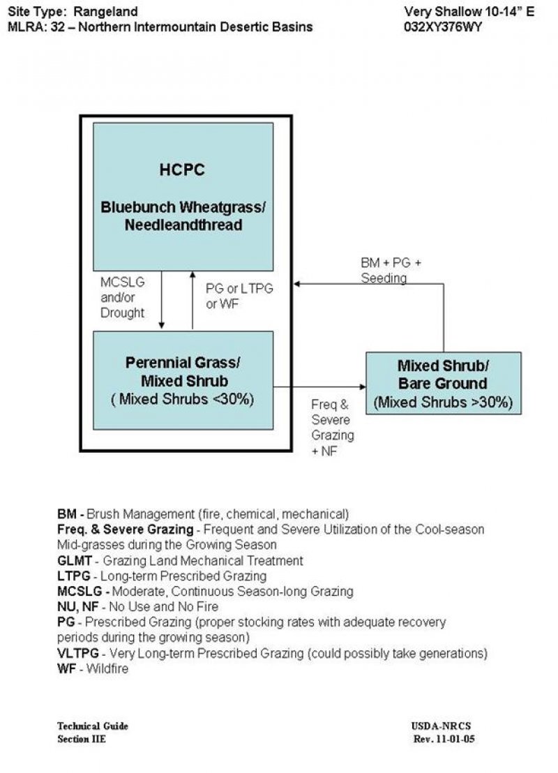
Click on box and path labels to scroll to the respective text.
