
Loamy Upland 10-14" p.z.
Scenario model
Current ecosystem state
Select a state

Management practices/drivers
Select a transition or restoration pathway
- Transition T1A More details
- Transition R2A More details
-
No transition or restoration pathway between the selected states has been described
Target ecosystem state
Select a state
State 1
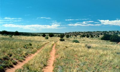
Reference State

Description
This state represents the most ecologically stable conditions in terms of resistance to erosion. Moreover, this state has the highest potential for productivity and plant diversity.
Submodel

Description
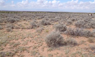
This state is characterized by a canopy dominated by sagebrush with a rabbitbrush and snakeweed. The understory is a mix of warm and cool season grasses along with annuals forbs.
Submodel
Mechanism
Season-long grazing providing little rest and recovery for preferred grazed plants during critical growing periods, coupled with high utilization. The introduction and establishment of invasive exotics is also a factor here.
Model keys
Briefcase
Add ecological sites and Major Land Resource Areas to your briefcase by clicking on the briefcase (![]() ) icon wherever it occurs. Drag and drop items to reorder. Cookies are used to store briefcase items between browsing sessions. Because of this, the number of items that can be added to your briefcase is limited, and briefcase items added on one device and browser cannot be accessed from another device or browser. Users who do not wish to place cookies on their devices should not use the briefcase tool. Briefcase cookies serve no other purpose than described here and are deleted whenever browsing history is cleared.
) icon wherever it occurs. Drag and drop items to reorder. Cookies are used to store briefcase items between browsing sessions. Because of this, the number of items that can be added to your briefcase is limited, and briefcase items added on one device and browser cannot be accessed from another device or browser. Users who do not wish to place cookies on their devices should not use the briefcase tool. Briefcase cookies serve no other purpose than described here and are deleted whenever browsing history is cleared.
Ecological sites
Major Land Resource Areas
The Ecosystem Dynamics Interpretive Tool is an information system framework developed by the USDA-ARS Jornada Experimental Range, USDA Natural Resources Conservation Service, and New Mexico State University.