Natural Resources
Conservation Service
Ecological site R035XF600NM
Malpais
Last updated: 5/19/2025
Accessed: 04/02/2026
General information
Provisional. A provisional ecological site description has undergone quality control and quality assurance review. It contains a working state and transition model and enough information to identify the ecological site.
Ecological site concept
This component is on lava flows, uplands, benches, mesas, and questas. The parent material consists of eolian deposits over alluvium derived from sandstone and shale. Depth to a root restrictive layer, basalt bedrock (lithic), is 10 to 20 inches. Slopes are 0 to 15 percent. The soil has a slightly sodic horizon within 30 inches of the soil surface.
Table 1. Dominant plant species
| Tree |
Not specified |
|---|---|
| Shrub |
(1) Artemisia tridentata |
| Herbaceous |
(1) Bouteloua gracilis |
Physiographic features
This component is on lava flows, uplands, benches, mesas, and questas. The parent material consists of eolian deposits over alluvium derived from sandstone and shale. Depth to a root restrictive layer, basalt bedrock (lithic), is 10 to 20 inches. Slopes are 0 to 15 percent and elevations range from about 5,600 to 7,500 feet above sea level.
Table 2. Representative physiographic features
| Landforms |
(1)
Mesa
(2) Terrace (3) Lava plateau |
|---|---|
| Flooding frequency | None |
| Ponding frequency | None |
| Elevation | 5,600 – 7,500 ft |
| Slope | 15% |
| Aspect | Aspect is not a significant factor |
Climatic features
Average annual precipitation varies from about 13 inches to just over 16 inches. Substantial fluctuations from year to year are common, ranging from a low of about 6 inches to a high of over 30 inches. Approximately one-half of the annual precipitation comes in the form of rainfall during the months of July, August, and September, although wintertime precipitation in the form of snow, sleet, or rain is sometimes significant. Spring and late fall months are normally dry.
The average frost-free period ranges from about 165 to 190 days and extends from approximately the third or fourth week in April to mid October. Average annual air temperatures are about 56 degrees F. Summer maximums can exceed 100 degrees F and winter minimums on occasion go below zero. Monthly mean temperatures generally exceed 70 degrees F for the period of June through August.
Growing conditions favor warm-season vegetation, although late winter and late summer precipitation is adequate to foster a significant cool-season component in the potential plant community. Occasional wet springs also create good conditions for annual forb production, but frequent winds from the west and southwest are common during this time of year and tend to deplete soil moisture at a critical time for the growth of these plants.
Climate data was obtained from http://www.wrcc.sage.dri.edu/summary/climsmnm.html web site using 50% probability for freeze-free and frost-free seasons using 28.5 degrees F and 32.5 degrees F respectively.
Table 3. Representative climatic features
| Frost-free period (average) | 142 days |
|---|---|
| Freeze-free period (average) | 146 days |
| Precipitation total (average) | 12 in |
Figure 1. Monthly precipitation range
Figure 2. Monthly average minimum and maximum temperature
Figure 3. Annual precipitation pattern
Figure 4. Annual average temperature pattern
Influencing water features
This site is not influenced by water from a wetland or stream.
Soil features
Slopes are 1 to 5 percent. This site is on lava flows, uplands, basalt uplands, mesas, and questas. The parent material consists of eolian deposits over alluvium derived from sandstone and shale. Depth to a root restrictive layer, basult bedrock (lithic), is 10 to 20 inches. The natural drainage class is well drained. Water movement in the most restrictive layer is moderately low. Available water to a depth of 60 inches is very low. Shrink-swell potential is high. This soil is not flooded. It is not ponded. There is no zone of water saturation within a depth of 72 inches. Organic matter content in the surface horizon is about 1 percent. Nonirrigated land capability classification is 7s. This soil does not meet hydric criteria. The calcium carbonate equivalent within 40 inches typically does not exceed 8 percent. The soil has a slightly sodic horizon within 30 inches of the soil surface.
SSA-692 McKinley County Area NM - 575 Pescado
Table 4. Representative soil features
| Surface texture |
(1) Stony fine sandy loam (2) Cobbly loam (3) Gravelly clay loam |
|---|---|
| Family particle size |
(1) Loamy |
| Drainage class | Well drained to moderately well drained |
| Permeability class | Slow to moderate |
| Soil depth | 10 – 20 in |
| Surface fragment cover <=3" | 5% |
| Surface fragment cover >3" | 10 – 20% |
| Available water capacity (0-40in) |
2.5 – 5 in |
| Calcium carbonate equivalent (0-40in) |
1 – 10% |
| Electrical conductivity (0-40in) |
2 mmhos/cm |
| Sodium adsorption ratio (0-40in) |
2 |
| Soil reaction (1:1 water) (0-40in) |
6.6 – 7.8 |
| Subsurface fragment volume <=3" (Depth not specified) |
10 – 15% |
| Subsurface fragment volume >3" (Depth not specified) |
35 – 45% |
Ecological dynamics
Overview
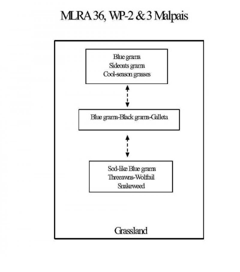
The Malpais site occurs on basalt-capped mesa tops, low hills and ridges, and on old lava flows. The soils are shallow over basalt and often cobbly or stony. This site is often associated with Loamy sites. The Loamy site can occur as low valleys dissecting the hills, ridges and old lava flows, or Loamy sites may occur with Malpais sites, as pockets of deeper soils on mesa tops. This is predominantly a grassland site characterized by a mixture of warm- and cool-season grasses, scattered shrubs, and a few trees. Blue grama and sideoats grama are the dominant grasses. Woody species may include winterfat, fourwing saltbush, piñon, and juniper. This site appears to be highly resistant to state change, as no alternate states were identified during our inventory. This resistance may be due in part to the high volume of rock fragments that occur on the soil surface, strong argillic horizons, and a shallow depth to bedrock. The cobbles and stones on the soil surface may help to protect the site from accelerated erosion and limit grazing accessibility by protecting grass bases. Argillic horizons and basalt bedrock can help to keep water perched and available, favoring shallow-rooted grasses.
State and transition model
More interactive model formats are also available.
View Interactive Models
More interactive model formats are also available.
View Interactive Models
Click on state and transition labels to scroll to the respective text
Ecosystem states
State 1 submodel, plant communities
State 1
Reference State
As of now, this is the only state identified. It is dominated by grasses.
Community 1.1
Historic Climax Plant Community
Grassland: Grasses are the dominant component of the historic plant community accounting for 75 to 85 percent of the total production. Blue grama and sideoats grama are the dominant grasses. Also characteristic are such species as western wheatgrass, little bluestem, spike muhly, alkali sacaton, black grama, galleta, and New Mexico feathergrass. Winterfat, fourwing saltbush, and broom snakeweed are common shrubs. A few piñon and juniper may be found widely scattered across the site. Changes in composition to the historic plant community may occur due to continuous heavy grazing. Typically, there is a decrease in cool season grasses, sideoats grama, little bluestem, and spike muhly. Communities dominated by blue grama, galleta, and black grama may result. Any of the three species may assume dominance depending on individual site characteristics. Blue grama seems to be the most grazing resistant species and under continued heavy use, a sod-like blue grama dominated community may result. Other species that are typically found in this community include threeawns, wolftail and snakeweed. Diagnosis: Grass composition is variable and cover ranges from uniform to patchy, with numerous small, spatially separated, bare patches. Shrubs and a few trees may be present on the site with a combined canopy cover averaging seven percent. Evidence of erosion such as pedestalling of grasses, rills, and gullies is limited.
Dominant plant species
-
blue grama (Bouteloua gracilis), grass
-
sideoats grama (Bouteloua curtipendula), grass
Figure 5. Annual production by plant type (representative values) or group (midpoint values)
Table 5. Annual production by plant type
| Plant type | Low (lb/acre) |
Representative value (lb/acre) |
High (lb/acre) |
|---|---|---|---|
| Grass/Grasslike | 340 | 610 | 880 |
| Forb | 43 | 77 | 110 |
| Shrub/Vine | 25 | 50 | 60 |
| Tree | 20 | 30 | 50 |
| Total | 428 | 767 | 1100 |
Table 6. Soil surface cover
| Tree basal cover | 5-10% |
|---|---|
| Shrub/vine/liana basal cover | 5-10% |
| Grass/grasslike basal cover | 20-25% |
| Forb basal cover | 5-10% |
| Non-vascular plants | 0% |
| Biological crusts | 0% |
| Litter | 5-10% |
| Surface fragments >0.25" and <=3" | 15-35% |
| Surface fragments >3" | 15-35% |
| Bedrock | 0% |
| Water | 0% |
| Bare ground | 8% |
Figure 6. Plant community growth curve (percent production by month). NM0301, R035XA109NM-Malpais-HCPC. Mixed warm/cool-season perennial grassland w/shrub and half-shrub component..
| Jan | Feb | Mar | Apr | May | Jun | Jul | Aug | Sep | Oct | Nov | Dec |
|---|---|---|---|---|---|---|---|---|---|---|---|
| J | F | M | A | M | J | J | A | S | O | N | D |
| 0 | 0 | 5 | 7 | 10 | 15 | 25 | 25 | 8 | 5 | 0 | 0 |
Community 1.2
Blue grama, black grama, galleta community
This community is dominated by blue grama, black grama, and galleta.
Dominant plant species
-
blue grama (Bouteloua gracilis), grass
-
black grama (Bouteloua eriopoda), grass
-
James' galleta (Pleuraphis jamesii), grass
Community 1.3
Sod-bound blue grama, shrubby
This community is dominated by sod-bound blue grama. Other well-represented grasses are threeawns, and wolfstail. Broom snakeweed is also relatively abundant.
Dominant plant species
-
broom snakeweed (Gutierrezia sarothrae), shrub
-
blue grama (Bouteloua gracilis), grass
-
threeawn (Aristida), grass
-
wolfstail (Lycurus), grass
Pathway P1.1A
Community 1.1 to 1.2
Continuous grazing.
Pathway P1.2A
Community 1.2 to 1.1
Prescribed/deferred grazing
Pathway P1.2B
Community 1.2 to 1.3
Prolonged continuous grazing.
Pathway P1.3A
Community 1.3 to 1.2
Prescribed/deferred grazing.
Additional community tables
Table 7. Community 1.1 plant community composition
| Group | Common name | Symbol | Scientific name | Annual production (lb/acre) | Foliar cover (%) | |
|---|---|---|---|---|---|---|
|
Grass/Grasslike
|
||||||
| 1 | 153–191 | |||||
| blue grama | BOGR2 | Bouteloua gracilis | 153–191 | – | ||
| 2 | 76–114 | |||||
| sideoats grama | BOCU | Bouteloua curtipendula | 76–114 | – | ||
| 3 | 76–114 | |||||
| spike muhly | MUWR | Muhlenbergia wrightii | 76–114 | – | ||
| western wheatgrass | PASM | Pascopyrum smithii | 76–114 | – | ||
| alkali sacaton | SPAI | Sporobolus airoides | 76–114 | – | ||
| 4 | 8–38 | |||||
| black grama | BOER4 | Bouteloua eriopoda | 85–38 | – | ||
| 5 | 38–114 | |||||
| needle and thread | HECO26 | Hesperostipa comata | 38–114 | – | ||
| 6 | 8–38 | |||||
| cane bluestem | BOBA3 | Bothriochloa barbinodis | 8–38 | – | ||
| little bluestem | SCSC | Schizachyrium scoparium | 8–38 | – | ||
| 7 | 8–38 | |||||
| James' galleta | PLJA | Pleuraphis jamesii | 8–38 | – | ||
| tobosagrass | PLMU3 | Pleuraphis mutica | 8–38 | – | ||
| 8 | 23–38 | |||||
| curly-mesquite | HIBE | Hilaria belangeri | 23–38 | – | ||
| dropseed | SPORO | Sporobolus | 23–38 | – | ||
| 9 | 8–23 | |||||
| threeawn | ARIST | Aristida | 8–23 | – | ||
| 10 | 8–23 | |||||
| squirreltail | ELEL5 | Elymus elymoides | 8–23 | – | ||
| 11 | 8–23 | |||||
| common wolfstail | LYPH | Lycurus phleoides | 8–23 | – | ||
|
Forb
|
||||||
| 12 | 8–38 | |||||
| annual buckwheat | ERAN4 | Eriogonum annuum | 8–38 | – | ||
| bastardsage | ERWR | Eriogonum wrightii | 8–38 | – | ||
| 13 | 8–38 | |||||
| Forb, annual | 2FA | Forb, annual | 8–38 | – | ||
| 14 | 8–23 | |||||
| Forb, perennial | 2FP | Forb, perennial | 8–23 | – | ||
|
Tree
|
||||||
| 15 | 8–23 | |||||
| oak | QUERC | Quercus | 85–23 | – | ||
| 16 | 8–46 | |||||
| juniper | JUNIP | Juniperus | 8–46 | – | ||
| twoneedle pinyon | PIED | Pinus edulis | 8–46 | – | ||
|
Shrub/Vine
|
||||||
| 17 | 8–23 | |||||
| rubber rabbitbrush | ERNAN5 | Ericameria nauseosa ssp. nauseosa var. nauseosa | 8–23 | – | ||
| Apache plume | FAPA | Fallugia paradoxa | 8–23 | – | ||
| rubber rabbitbrush | ERNAN5 | Ericameria nauseosa ssp. nauseosa var. nauseosa | 8–23 | – | ||
| Apache plume | FAPA | Fallugia paradoxa | 8–23 | – | ||
| 18 | 23–61 | |||||
| winterfat | KRLA2 | Krascheninnikovia lanata | 23–61 | – | ||
| 19 | 8–23 | |||||
| skunkbush sumac | RHTR | Rhus trilobata | 8–23 | – | ||
| 20 | 0–8 | |||||
| broom snakeweed | GUSA2 | Gutierrezia sarothrae | 0–8 | – | ||
Interpretations
Animal community
Habitat for Wildlife:
This site provides habitat which can support a resident animal community characterized by mule deer, rock squirrel, brush mouse, Stephen’s woodrat, gray fox, bobcat, scaled quail, ladderbacked woodpecker, scrub jay, common bushtit, rock wren, brown towhee, rufous-crowned sparrow, chipping sparrow, ash-throated flycatcher, short-horned lizard, collared lizard, Eastern fence lizard, tree lizard, red-spotted toad, and black-tailed rattlesnake.
Hydrological functions
The runoff curve numbers are determined by field investigations using hydrologic cover
conditions and hydrologic soil groups.
Hydrologic Interpretations
Soil Series-----------Hydrologic Group
Pescado-----------------------D
Recreational uses
This site offers recreation potential for hiking, picnicking, camping, nature observation and photography, bird watching, and hunting for mule deer, mourning dove, and quail. When favorable growing-season moisture conditions occur, a colorful display of wildflowers may be seen.
Wood products
This site has little or no significant value for wood products.
Other products
Grazing:
This site is suitable for grazing in all seasons of the year. It is best adapted for cattle and horses, but can also be utilized by sheep and goats. Continuous yearlong grazing may, however, result in a decline or disappearance of cool-season grasses and preferred browse plants. If grazing use
is heavy or prolonged, such plants as sideoats grama, little bluestem, spike muhly, and black grama will also decrease. Ordinarily, as retrogression continues, blue grama, tobosa or galleta, curly mesquite, threeawns, and broom snakeweed begin to dominate. Eventually, even blue grama may decline. The site is not highly erodible, and reasonably rapid recovery can be effected by good grazing management.
Other information
Guide to Suggested Initial Stocking Rate Acres per Animal Unit Month
Similarity Index---------------Ac/AUM
100 - 76----------------------3.0 – 4.2
75 – 51----------------------4.0 – 6.5
50 – 26----------------------6.0 – 10.0
25 – 0-----------------------10.0+
Supporting information
Type locality
| Location 1: Catron County, NM | |
|---|---|
| Location 2: McKinley County, NM | |
| Location 3: Sandoval County, NM |
Other references
Data collection for this site was done in conjunction with the progressive soil surveys within the New Mexico and Arizona Plateaus and Mesas 36 Major Land Resource Area of New Mexico. This site has been mapped and correlated with soils in the following soil surveys: McKinley, Cibola, Sandoval.
Characteristic Soils Are:
Pescado
Contributors
Peter Lefebvre
Approval
Kendra Moseley, 5/19/2025
Rangeland health reference sheet
Interpreting Indicators of Rangeland Health is a qualitative assessment protocol used to determine ecosystem condition based on benchmark characteristics described in the Reference Sheet. A suite of 17 (or more) indicators are typically considered in an assessment. The ecological site(s) representative of an assessment location must be known prior to applying the protocol and must be verified based on soils and climate. Current plant community cannot be used to identify the ecological site.
| Author(s)/participant(s) | |
|---|---|
| Contact for lead author | |
| Date | 05/22/2025 |
| Approved by | Kendra Moseley |
| Approval date | |
| Composition (Indicators 10 and 12) based on | Annual Production |
Indicators
-
Number and extent of rills:
-
Presence of water flow patterns:
-
Number and height of erosional pedestals or terracettes:
-
Bare ground from Ecological Site Description or other studies (rock, litter, lichen, moss, plant canopy are not bare ground):
-
Number of gullies and erosion associated with gullies:
-
Extent of wind scoured, blowouts and/or depositional areas:
-
Amount of litter movement (describe size and distance expected to travel):
-
Soil surface (top few mm) resistance to erosion (stability values are averages - most sites will show a range of values):
-
Soil surface structure and SOM content (include type of structure and A-horizon color and thickness):
-
Effect of community phase composition (relative proportion of different functional groups) and spatial distribution on infiltration and runoff:
-
Presence and thickness of compaction layer (usually none; describe soil profile features which may be mistaken for compaction on this site):
-
Functional/Structural Groups (list in order of descending dominance by above-ground annual-production or live foliar cover using symbols: >>, >, = to indicate much greater than, greater than, and equal to):
Dominant:
Sub-dominant:
Other:
Additional:
-
Amount of plant mortality and decadence (include which functional groups are expected to show mortality or decadence):
-
Average percent litter cover (%) and depth ( in):
-
Expected annual annual-production (this is TOTAL above-ground annual-production, not just forage annual-production):
-
Potential invasive (including noxious) species (native and non-native). List species which BOTH characterize degraded states and have the potential to become a dominant or co-dominant species on the ecological site if their future establishment and growth is not actively controlled by management interventions. Species that become dominant for only one to several years (e.g., short-term response to drought or wildfire) are not invasive plants. Note that unlike other indicators, we are describing what is NOT expected in the reference state for the ecological site:
-
Perennial plant reproductive capability:
Print Options
Sections
Font
Other
The Ecosystem Dynamics Interpretive Tool is an information system framework developed by the USDA-ARS Jornada Experimental Range, USDA Natural Resources Conservation Service, and New Mexico State University.
Click on box and path labels to scroll to the respective text.