Natural Resources
Conservation Service
Ecological site R036XB014NM
Shallow Loam
Last updated: 4/01/2025
Accessed: 02/08/2026
General information
Provisional. A provisional ecological site description has undergone quality control and quality assurance review. It contains a working state and transition model and enough information to identify the ecological site.
MLRA notes
Major Land Resource Area (MLRA): 036X–Southwestern Plateaus, Mesas, and Foothills
This MLRA is in New Mexico (58 percent), Colorado (32 percent), and Utah (10 percent). It makes up about 23,885 square miles (61,895 square kilometers). The major towns in the area are Cortez and Durango, Colorado; Santa Fe and Los Alamos, New Mexico; and Monticello, Utah. The city of Grand Junction in Colorado, and Interstate 70 are just outside the northern tip of this area. Interstate 25 crosses through the middle of the MLRA, and U.S. Highway 550 runs along the MLRA’s southwest boundary in New Mexico. Mesa Verde National Park and the Bandelier, Hovenweep, Natural Bridges, Yucca House, and Colorado National Monuments are in the area. Many Indian reservations are in this MLRA. The largest are the Southern Ute, Ute Mountain, and Jicarilla Apache Reservations. Also in the area are the Cochiti, Jemez, Nambe, Navajo, Picuris, Pojoaque, San Felipe, San Ildefonso, San Juan, Sandia, Santa Ana, Santa Clara, Santa Domingo, Taos, Tesuque, and Zia Reservations.
This MLRA is within the Intermontane Plateaus Region. It is mainly in the Canyon Lands and Navajo Sections of the Colorado Plateau Province, partly in the Mexican Highland Section of the Basin and Range Province, and extends marginally into the Southern Rocky Mountains Province. Underlying sedimentary rock controls the landforms seen in most places, but fluvial landforms are in the Rio Grande Rift Basin at the southeastern portion of the MLRA. The elevation is commonly 4,600 to 8,500 feet (1,400 to 2,590 meters) and is generally highest (as high as 9,300 feet or 2,835 meters) in the foothills and high mesas that border the Southern Rocky Mountains. Relief is typically less than 1,500 feet (455 meters). The upper reaches of the Rio Grande and San Juan Rivers and their tributaries are in the part of this MLRA, near the Colorado and New Mexico state lines. The Rio Puerco and Rio Chama Rivers are in the New Mexico part of the MLRA. The Dolores and San Miguel Rivers are in the Colorado part of the MLRA, and a short reach of the Colorado River crosses this MLRA near the Utah and Colorado state lines.
Predominantly horizontal sedimentary beds from the Jurassic, Cretaceous, and Tertiary Periods underlie most of the MLRA. Representative formations are the Morrison Formation, Dakota Sandstone, Mancos Shale, Cliff House Sandstone, and other members of the Mesa Verde Group, including the Animas Formation and the San Jose Formation. The sedimentary rocks have eroded into plateaus, mesas, hills, and canyons. Thick eolian deposits from the Pleistocene Epoch blanket the tops of mesas in some areas. Small areas of Tertiary and Quaternary volcanic rocks, including cinder cones and lava flows, are in the Rio Grande Rift Basin in New Mexico. Broad valleys in the rift basin have accumulations of deep alluvial sediments, and fan remnants are commonplace.
The dominant soil orders in this MLRA are Alfisols, Inceptisols, Mollisols, Entisols, and Aridisols. The soil moisture regime is mainly ustic, but an aridic soil moisture regime that borders on ustic is present in some areas. The soil temperature regime is mesic or frigid. Mineralogy is dominantly mixed or smectitic. In warmer places of the MLRA, shallow Ustorthents (Menefee Series) formed in residuum on shale hills and mesas. Shallow Haplustalfs (Arabrab Series) and Torriorthents (Rizno Series) formed in material weathered from sandstone on mesas, hills, and cuestas. Moderately deep, loamy Haplargids (Gapmesa Series) and very deep, loamy Haplustalfs (Orlie series) formed in slope alluvium derived from sandstone and shale on mesas or fan remnants. Very deep, clayey Haplustepts (Roques series) formed in alluvium derived from shale on valley sides. Very deep, silty Haplustalfs (Cahona and Wetherill Series) formed in eolian deposits on hills and mesas. In cooler places, very deep, clayey Haplustalfs (Goldbug Series) formed in slope alluvium derived from sandstone and shale on hills and mesas. Shallow Argiustolls (Fivepine Series) formed in slope alluvium and residuum derived from sandstone. Moderately deep Argiustolls (Nortez Series) formed in eolian deposits derived from sandstone on hills and mesas.
LRU notes
MLRA 36X is in the Colorado Plateau, a physiographic province existing throughout eastern Utah, western Colorado, western New Mexico, and northern Arizona. Uplifted plateaus, canyons, and other land features formed by erosion are characteristic of the MLRA. The Colorado Plateau lies south of the Uintah Mountains, north of the Mogollon Rim in the Transition Highlands, west of the Rocky Mountains, and east of the highlands in central Utah. MLRA 36 is in the higher-elevation portion of the Colorado Plateau, which has
broken topography and lacks perennial water sources. This MLRA has a long history of use by prehistoric humans, and archaeological evidence indicates their activities modified the native pinyon-juniper woodlands. Additional alterations to the native conditions of the area occurred at the time of European settlement (Cartledge and Propper, 1993). Historically, this area also included the natural influences of herbivory, fire, and climate. However, the area rarely served as a habitat for large herds of native herbivores or large, frequent fires due to the broken topography. This ecological site is highly variable, and plant community composition varies in response to water fluctuations.
The lower part of MLRA 36X developed under climatic conditions of hot and dry summers, summer rain showers, mild winter temperatures, and little to no snow. This area has climatic fluctuations, ranging from above-average annual precipitation to years of drought, and prolonged droughts are commonplace.
Forbs are the most dynamic vegetative component of the plant communities in the MLRA, and species composition can vary up to fourfold on any given ecological site (Passey et al., 1982). The precipitation and climate of MLRA 36X are conducive to producing pinyon-and-juniper and sagebrush complexes and highly-productive sites at the bottoms of canyons. The dominant species in the Colorado Plateau are Wyoming big sagebrush (Artemisia tridentata var. wyomingensis), mountain big sagebrush (Artemisia tridentata var. vaseyana), and black sagebrush (Artemisia nova), basin big sagebrush (Artemisia tridentata ssp. tridentata), Utah juniper (Juniperus utahensis), oneseed juniper (Juniperus monosperma), and twoneedle pinyon (Pinus edulis). Oneseed juniper can discontinue active growth under limited moisture conditions and resume growth when moisture availability improves. This growth pattern may represent a critical adaptation allowing them to survive on very arid sites. It is possible that drought may kill small trees, but mature oneseed junipers are resilient to drought, especially in comparison to twoneedle pinyon (Johnsen, 1962).
The Land Resource Unit (LRU) has 10 to 16 inches of annual precipitation and a mesic soil temperature regime. The LRU is in the lower part of MLRA 36X and is dominated by monsoons in summer, unlike the upper part of MLRA 36X.
Classification relationships
NRCS & BLM:
Major Land Resource Area 36, Southwestern Plateaus Mesas and Foothills (United States Department of Agriculture, Natural Resources Conservation Service, 2006).
USFS:
313Bd Chaco Basin High Desert Shrubland and 313Be San Juan Basin North subsections < 313B Navaho Canyonlands Section < 313 Colorado Plateau Semi-Desert (Cleland, et al., 2007).
315Ha Central Rio Grande Intermontane, and 315Hb North Central Rio Grande Intermontane subsections <315H Central Rio Grande Intermontane Section < 315 Southwest Plateau and Plains Dry Steppe and Shrub (Cleland, et al., 2007).
315Ad Chupadera High Plains Grassland subsections <315A Pecos Valley Section < 315 Southwest Plateau and Plains Dry Steppe and Shrub (Cleland, et al., 2007).
331Jb San Luis Hills and 331Jd Southern San Luis Grasslands subsections <331J Northern Rio Grande Basin Section < 331 Great Plains- Palouse Dry Steppe (Cleland, et al., 2007).
M313Bd Manzano Mountains Woodland subsection Sacramento-Monzano Mountains Section M313 Arizona-New Mexico Mountains Semi-Desert - Open Woodland - Coniferous Forest - Alpine Meadow
M331Fg Sangre de Cristo Mountains Woodland and M331Fh Sangre de Cristo Mountains Coniferous Forest subsection M331F Southern Parks and Rocky Mountain Range Section M331 Southern Rocky Mountain Steppe - Open Woodland - Coniferous Forest - Alpine Meadow M331Gk Brazos Uplift and M331Gm Jemez and San Pedro Mountains Coniferous Forest subsections M331G South Central Highlands Section M331 Southern Rocky Mountain Steppe - Open Woodland - Coniferous Forest - Alpine Meadow
EPA:
21d Foothill Shrublands and 21f Sedimentary Mid-Elevation Forests < 21 Southern Rockies < 6.2 Western Cordillera < 6 Northwestern Forested Mountains (Griffith, 2006).
20c Semiarid Benchlands and Canyonlands < 20 Colorado Plateaus < 10.1 Cold Deserts < 10 North American Deserts (Griffith, 2006).
22m Albuquerque Basin, 22i San Juan/Chaco Tablelands and Mesas, 22h North Central New Mexico Valleys and Mesas, 22f Taos Plateau, and 22g Rio Grande Floodplain, < 22 Arizona/New Mexico Plateau < 10.1 Cold Deserts < 10 North American Deserts (Griffith, 2006).
USGS:
Colorado Plateau Province (Navajo and Datil ection) Southern Rocky Mountains Basin and Range (Mexican Highland and Sacramento Section)
Ecological site concept
The Shallow Loam Ecological Site in MLRA 36XB originates from the pre-existing Shallow Loam (R036XB014NM) range site (NRCS, 2003). The effective precipitation for the site ranges from 10 to 16 inches. This site is on ridges, hills, interfluves of undulating plateaus, escarpments, and steeply-sloping areas of cuestas and mesas. The site has an aridic ustic or ustic aridic soil moisture regime and a mesic soil temperature regime. The surface soil texture is commonly sandy loam or loam, and cobbles or gravel are typically present.
Associated sites
| R035XA130NM |
Shale Hills 10-14"p.z. The Shale Hills 10-14” P.Z. Ecological Site has an annual precipitation range of 10 to 16 inches. The slope for the site ranges from 3 to 35 percent. The soils are deep, and surface textures is commonly cobbly clay loam or very stony silty clay loam. Subsoil texture is clay or clay loam. The soils are calcareous at a depth of 14 to 20 inches below the surface down to 60 inches. The parent material is shale. Landforms include side slopes of mesas and small arroyos dissecting the landscape. |
|---|---|
| R035XG114NM |
Gravelly The Gravelly Ecological Site has an annual precipitation range of 10 to 16 inches. The slope for the site ranges from 0 to 35 percent. Soils are moderately deep to very deep. The surface horizon and underlying horizons have a texture of gravelly or very gravelly loam, sandy loam, or fine sandy loam. The site is on gently or strongly sloping rolling hills, ridges, or natural arroyos dissecting the landscape. The site can also be adjacent to rock outcrops or in very steeply sloping areas of badlands. |
Similar sites
| R036XY408CO |
Basin Shale The Basin Shale Ecological Site has an annual precipitation range of 9 to 12 inches. The slope for the site ranges from 1 to 20 percent. The soils are shallow to moderately deep. Surface texture is commonly silty clay loam, and subsoil texture is silty clay or clay loam. Parent material is shale alluvium and residuum from the Mancos and Morrison Formations. Landforms are low alluvial terraces, ridges, hills, structural benches, and alluvial fans. |
|---|
Table 1. Dominant plant species
| Tree |
Not specified |
|---|---|
| Shrub |
(1) Artemisia nova |
| Herbaceous |
(1) Pascopyrum smithii |
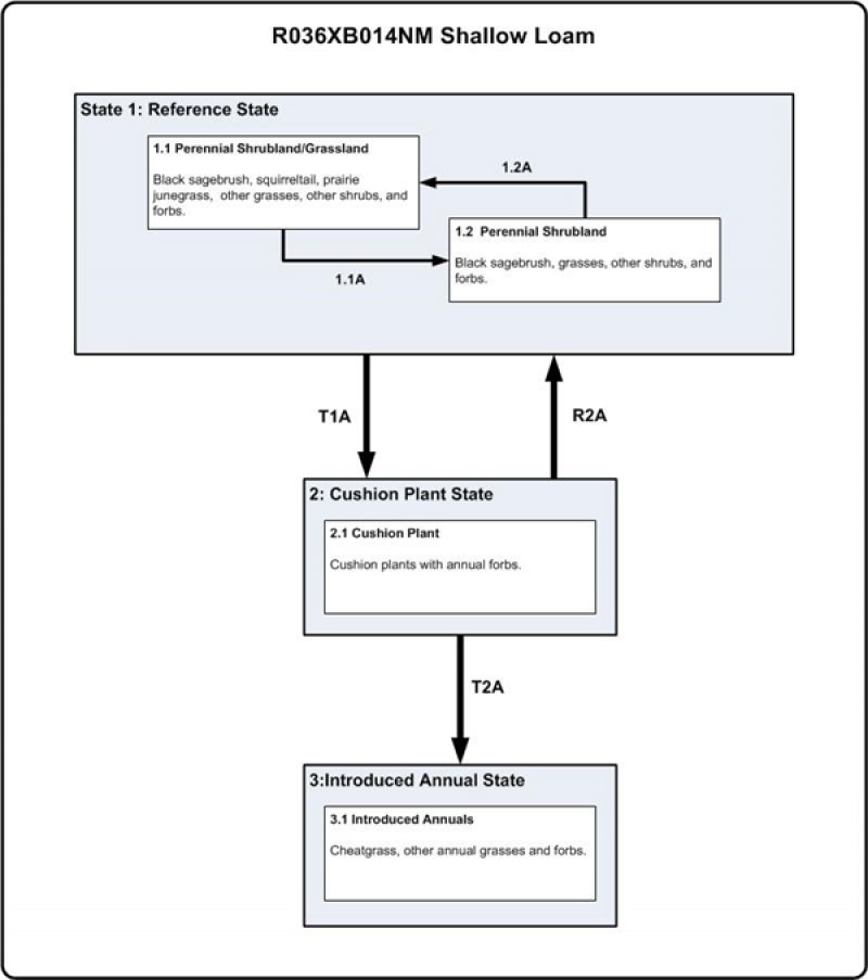
Click on box and path labels to scroll to the respective text.
Ecosystem states
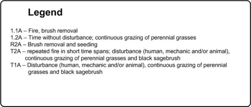
| T1A | - | Disturbance (human, mechanical, or animal), Continuous grazing of perennial grasses and black sagebrush |
|---|---|---|
| R2A | - | Brush removal and seeding |
| T2A | - | Repeated fires within a short timespan, Disturbance (human, mechanical, or animal), Continuous grazing of perennial grasses and black sagebrush |
State 1 submodel, plant communities
| 1.1A | - | Fire, Brush removal |
|---|---|---|
| 1.2A | - | Time without disturbance, Continuous grazing of perennial grasses |

