Natural Resources
Conservation Service
Ecological site R036XB015NM
Shallow Savanna
Last updated: 12/20/2024
Accessed: 04/11/2025
General information
Provisional. A provisional ecological site description has undergone quality control and quality assurance review. It contains a working state and transition model and enough information to identify the ecological site.

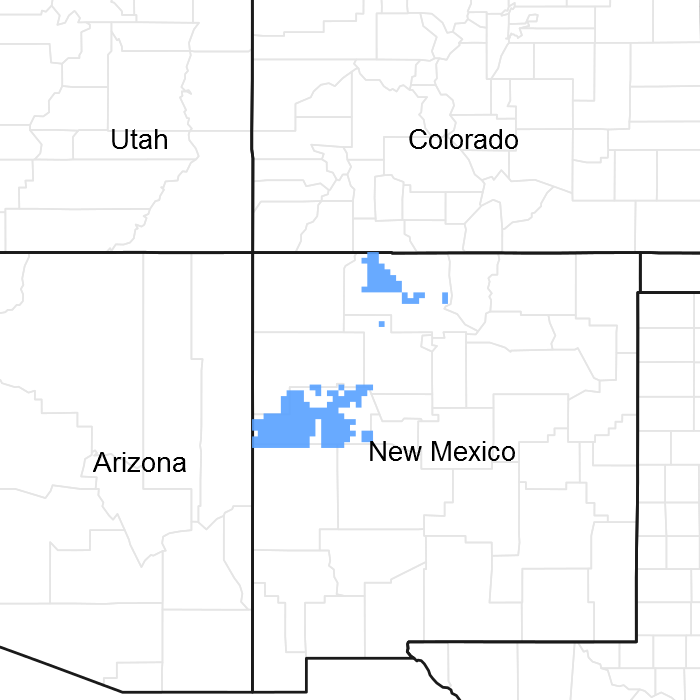
Figure 1. Mapped extent
Areas shown in blue indicate the maximum mapped extent of this ecological site. Other ecological sites likely occur within the highlighted areas. It is also possible for this ecological site to occur outside of highlighted areas if detailed soil survey has not been completed or recently updated.
MLRA notes
Major Land Resource Area (MLRA): 036X–Southwestern Plateaus, Mesas, and Foothills
Shallow Savanna is an ecological site that is found on hills, breaks and mesas of bedrock controlled landscapes in MLRA 36 (Southwestern Plateaus Mesas and Foothills). The southern portion MLRA 36 is illustrated yellow color on the map where this site occurs. The site concept was established in the Southwestern Plateaus. Mesas, and Foothills – Warm Semiarid Mesas and Plateaus LRU (Land Resource Area). This LRU has 10 to 16 inches of precipitation and has a mesic temperature regime. Lower part of MLRA 36 is dominated by summer precipitation for monsoons, unlike the upper part of MLRA 36 which is almost an equal split.
Classification relationships
NRCS & BLM:
Major Land Resource Area 36, Southwestern Plateaus Mesas and Foothills (United States Department of Agriculture, Natural Resources Conservation Service, 2006).
USFS:
313Bd Chaco Basin High Desert Shrubland and 313Be San Juan Basin North subsections < 313B Navaho Canyonlands Section < 313 Colorado Plateau Semi-Desert (Cleland, et al., 2007).
315Ha Central Rio Grande Intermontane, and 315Hb North Central Rio Grande Intermontane subsections <315H Central Rio Grande Intermontane Section < 315 Southwest Plateau and Plains Dry Steppe and Shrub (Cleland, et al., 2007).
315Ad Chupadera High Plains Grassland subsections <315A Pecos Valley Section < 315 Southwest Plateau and Plains Dry Steppe and Shrub (Cleland, et al., 2007).
331Jb San Luis Hills and 331Jd Southern San Luis Grasslands subsections <331J Northern Rio Grande Basin Section < 331 Great Plains- Palouse Dry Steppe (Cleland, et al., 2007).
M313Bd Manzano Mountains Woodland subsection < Sacramento-Monzano Mountains Section < M313 Arizona-New Mexico Mountains Semi-Desert - Open Woodland - Coniferous Forest - Alpine Meadow
M331Fg Sangre de Cristo Mountains Woodland and M331Fh Sangre de Cristo Mountains Coniferous Forest subsection < M331F Southern Parks and Rocky Mountain Range Section< M331 Southern Rocky Mountain Steppe - Open Woodland - Coniferous Forest - Alpine Meadow
M331Gk Brazos Uplift and M331Gm Jemez and San Pedro Mountains Coniferous Forest subsections < M331G South Central Highlands Section < M331 Southern Rocky Mountain Steppe - Open Woodland - Coniferous Forest - Alpine Meadow
EPA:
21d Foothill Shrublands and 21f Sedimentary Mid-Elevation Forests < 21 Southern Rockies < 6.2 Western Cordillera < 6 Northwestern Forested Mountains (Griffith, 2006).
20c Semiarid Benchlands and Canyonlands < 20 Colorado Plateaus < 10.1 Cold Deserts < 10 North American Deserts (Griffith, 2006).
22m Albuquerque Basin, 22i San Juan/Chaco Tablelands and Mesas, 22h North Central New Mexico Valleys and Mesas, 22f Taos Plateau, and 22g Rio Grande Floodplain, < 22 Arizona/New Mexico Plateau < 10.1 Cold Deserts < 10 North American Deserts (Griffith, 2006).
USGS:
Colorado Plateau Province (Navajo and Datil Section) Southern Rocky Mountains
Basin and Range (Mexican Highland and Sacramento Section)
Ecological site concept
The 36XB Shallow Savanna ecological site was drafted from the existing Shallow Savanna (R036XB015NM) range site MLRA 36XB (NRCS, 2003). This site occurs on narrow ridges, hills, breaks and mesas of bedrock controlled landscapes. The soil surface is typically very cobbly loam, very cobbly sandy loam or cobbly clay loam in textures. The soils are clay and fine in the control section. It has an aridic ustic/ustic arid moisture regime and mesic temperature regime. The effective precipitation ranges from 10 to 16 inches
Associated sites
| R036XB016NM |
Loamy Savanna Loamy Savanna - Slopes are 1-15%; Soils are moderately deep to deep; soil surface range from very fine sandy loam to clay loam. Subsoil is fine-textured. Landforms are nearly level to undulating plains, hills, ridges, and mesa tops, although it may occur on more rolling landscapes. |
|---|---|
| F036XA001NM |
Pinyon Upland South of Gallup 13-16 - Slope 1-35%; Soils are very shallow to shallow and non-skeletal; soil surface is loam, channery loam or clay loam. Landforms are broad mesas, cuestas, and hills interspersed with numerous deep canyons and dry washes. |
| F036XB133NM |
Pinyon-Utah juniper/skunkbush sumac Pinyon-Juniper/Skunkbush Sumac - Slopes are 1-65%; Soils are moderately deep to deep and skeletal and non-skeletal. Surface texture of gravelly to very gravelly sandy loam, very gravelly loam, loam, para-gravelly-ashy loamy coarse sand, and extremely cobbly coarse sandy loam with a sandy subsoil. Landform is mesas, hills, fan piedmonts, valley sides, plateaus, mountain slopes, structural benches, breaks and ridges. |
| R036XB006NM |
Loamy Loamy - Slopes are 1-15%; Soils are moderately deep to deep; soil surface range from loam, gravelly loam, loamy fine sand, fine sandy loam, sandy loam, silt loam and clay loam. Subsoil is loamy and range from loam to clay loam. Landforms are mesas, plateaus, fan remnant, terraces, dipslopes on cuestas, and broad upland valley sides. |
| R036XB007NM |
Malpais Malpais - Slopes 1-15%; soils are very shallow to shallow and skeletal and not skeletal; soil surface are loam, stony to very stony loam, very cobbly loam, fine sandy loam, very cobbly fine sandy loam, stony silt loam, stony silty clay loam, and cobbly silty clay loam; Parent materials are basalt influences but can have sometimes influence from sandstone and/or shale. Landforms nearly level to gently sloping mesas, lava plateaus, lava flows, lava flows on valley floors, and ridges. |
Similar sites
| R036XB016NM |
Loamy Savanna Loamy Savanna - Slopes are 1-15%; Soils are moderately deep to deep; soil surface range from very fine sandy loam to clay loam. Subsoil is fine-textured. Landforms are nearly level to undulating plains, hills, ridges, and mesa tops, although it may occur on more rolling landscapes. |
|---|
Table 1. Dominant plant species
| Tree |
Not specified |
|---|---|
| Shrub |
Not specified |
| Herbaceous |
Not specified |
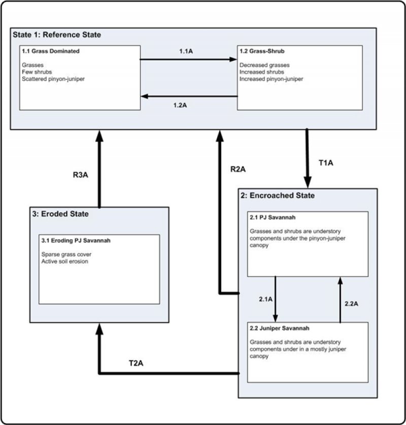
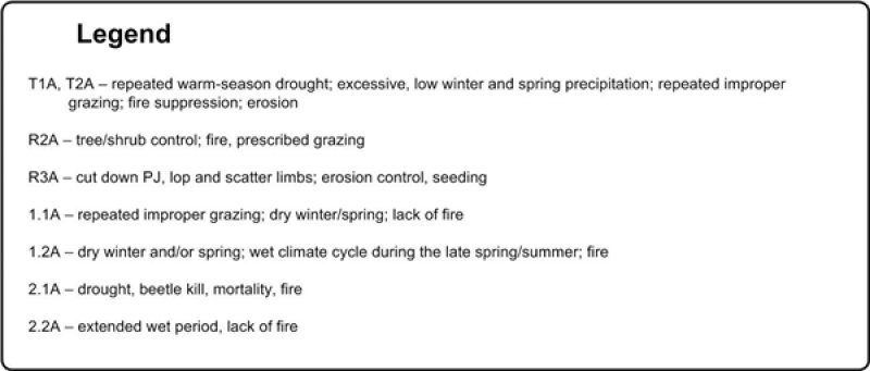
Click on box and path labels to scroll to the respective text.

