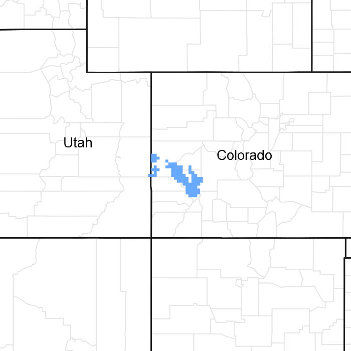
Provisional. A provisional ecological site description has undergone quality control and quality assurance review. It contains a working state and transition model and enough information to identify the ecological site.
Areas shown in blue indicate the maximum mapped extent of this ecological site. Other ecological sites likely occur within the highlighted areas. It is also possible for this ecological site to occur outside of highlighted areas if detailed soil survey has not been completed or recently updated.
MLRA notes
Major Land Resource Area (MLRA): 036X–Southwestern Plateaus, Mesas, and Foothills
Stony Foothills ecological site is found on escarpments, moraines, fan remnants, dipslopes, outwash fans, and colluvial aprons in MLRA 36 (Southwestern Plateaus Mesas and Foothills). The MLRA 36 is illustrated orange color on the map. The ecological site locations as assigned in soil survey map units are shown in pink color.
The site concept was established within the MLRA 36 Foothill/Upland regions. This zone is 12 to 16 inches of precipitation and has a mesic temperature regime. This site has bimodal precipitation that is dominated by pinyon and Utah juniper with an open shrub understory.
Classification relationships
NRCS & BLM: Major Land Resource Area 36, Southwestern Plateaus Mesas and Foothills (United States Department of Agriculture, Natural Resources Conservation Service, 2006).
USFS:
341Bd - Salt Anticline Benchlands, 341Bo - North Uncompahgre Plateau and 341Bp - Uncompahgre Plateau Subsections <341B Northern Canyonlands Section < 341 Intermountain Semi-desert and Desert (Cleland, et al., 2007).
EPA:
20b Shale Deserts and Sedimentary Basins and 20c Semiarid Benchlands and Canyonlands, < 20 Colorado Plateau < 10.l Cold Deserts < 10 North American Deserts (Griffith, 2006).
USGS: Colorado Plateau Province (Canyonlands Section)
Ecological site concept
The 36X Stony Foothills ecological site was drafted from the existing Stony Foothills Range Site 34B (SCS, August, 1975). This site was written prior to MLRA 36 being recognized in Colorado and this area was called MLRA 34X on escarpments, moraines, fan remnants, a d 48X when it was written. This site occurs dipslopes, outwash fans, and colluvial aprons. The soils are loamy-skeletal textures. The soils associated with this site are shallow to a calcic and argillic horizons, depth to these horizon range from 7 to 21 inches. The most common parent materials are colluvium derived from igneous and sedimentary rock, till derived from igneous, metamorphic and sedimentary rock, slope alluvium derived from igneous and metamorphic rock, and alluvium derived from igneous, metamorphic and sedimentary rock. It is an open pinyon-juniper tree community with sagebrush in the understory community. It has an aridic ustic moisture regime and mesic temperature regime. The effective precipitation ranges from 12 to 16 inches.
Loamy Foothills occurs on hills, benches and mesas on moderately deep to deep loamy textured soils derived from alluvium, slope alluvium eolian deposits, and colluvium. It is a Wyoming big sagebrush – Muttongrass community. It has an aridic ustic moisture regime and mesic temperature regime. The effective precipitation ranges from 12 to 16 inches.
Clayey Foothills occurs on benches, foot-slopes, fans, and valley. Soils are moderately deep to deep and have marine shale as parent materials. The soil textures are clay loam to clay. Dominant plants are Wyoming Big Sagebrush and western wheatgrass. This site has a high potential for shrink swell.
Shallow Clay Loam Pinyon-Juniper is a gentle sloped (<25% slopes) site with shallow soils that are clayey in texture. This site is dominated by Utah Juniper and scattered pinyon. This site may have Wyoming big sagebrush in the understory. This site is in the 8 to 12 inch precipitation zone of semidesert.
Mountain Pinyon is a gentle sloped (<25% slope) site with very shallow and shallow soils that are loamy in texture. This site is dominated by Pinyon, Utah Juniper. This site may have oakbrush in the understory. This site is in the 12 to 16 inch precipitation zone of foothills/upland.
Wet Meadow has season-long ground water within 3.5 feet of the surface and is occasionally flooded. This site is poorly drained. Sedges and rushes are the dominant plants on this site.
Shallow Clay Loam Pinyon-Juniper is a gentle sloped (<25% slopes) site with shallow soils that are clayey in texture. This site is dominated by Utah Juniper and scattered pinyon. This site may have Wyoming big sagebrush in the understory. This site is in the 8 to 12 inch precipitation zone of semidesert.
Semidesert Juniper Loam is a gentle sloped (<25-30% slope) site with shallow soils that are loamy in texture. This site is dominated by Utah Juniper and scattered pinyon. This site may have Wyoming big sagebrush in the understory. This site is in the 8 to 12 inch precipitation zone of semidesert.
Mountain Pinyon is a gentle sloped (<25% slope) site with very shallow and shallow soils that are loamy in texture. This site is dominated by Pinyon, Utah Juniper. This site may have oakbrush in the understory. This site is in the 12 to 16 inch precipitation zone of foothills/upland.
Steep Shallow Clay Loam Pinyon-Juniper is a very steep sloped (> 25% slopes) site with shallow soils that are clayey in texture. This site is dominated by Utah Juniper and scattered pinyon. This site may have Wyoming big sagebrush in the understory. This site is in the 8 to 12 inch precipitation zone of semidesert.
Steep Colluvial Slopes is a very steep (>25% slope) sloped site with very shallow to shallow soils that are clayey in texture. This site is dominated by Utah Juniper and pinyon. This site may have Wyoming big sagebrush in the understory. This site has higher precipitation (12 to 16") than Semidesert Loam (8 to 12"). The temperature is slightly cooler than the semidesert site. Foothill site will be found at elevations above the semidesert site. The soils are similar in nature.
Cobbly Foothill is a gentle sloped (<20% slope) site with moderately deep to deep soils that are loamy-skeletal in texture. Common surface textures are cobbly or gravelly loam. This site is dominated by Big sagebrush, western wheatgrass, Pinyon, and Utah Juniper. This site is in the 12 to 16 inch precipitation zone of foothills/upland.
Loamy Mesa Top is a gentle sloped (<15% slope) site with moderately deep to deep soils that are coarse loamy in texture. This site is shallow to calcic horizon. The typical profile is border-line skeletal which reduces the water holding capacity of this site. It is dominated by Pinyon, Utah Juniper, muttongrass and Indian ricegrass. This site is in the 15 to 18 inch precipitation zone of foothills/upland.
Shallow Loamy Mesa Top is a gentle sloped (<25% slope) site with very shallow and shallow soils that are loamy in texture. This site is dominated by Pinyon, Utah Juniper, muttongrass and Indian ricegrass. This site is in the 15 to 18 inch precipitation zone of foothills/upland.
Southwestern Mountain (Pinyon-Juniper) is a gentle sloped (<25% slope) site with very shallow and shallow soils that are loamy or loamy-skeletal in texture. This site is dominated by Pinyon, Utah Juniper, Wyoming big sagebrush, muttongrass and Indian ricegrass. This site may have oakbrush in the understory. This site is in the 12 to 16 inch precipitation zone of foothills/upland.
This site is found on rocky soils on escarpments, moraines, fan remnants, dipslopes, outwash fans, structural benches, and colluvial aprons. Slopes range from 3 to 30%. Elevation ranges from 6000 to 7500 feet above sea level. At higher elevations the site occupies south and west exposures. At lower elevations it occurs on north and east exposures.
Table 2. Representative physiographic features
Landforms
(1) Escarpment (2) Moraine (3) Fan remnant
Flooding frequency
None
Ponding frequency
None
Elevation
6,000–7,500 ft
Slope
3–30%
Aspect
N, S, W
Climatic features
Average annual precipitation is about 12 to 16 inches. Of this, 40-50% falls as snow, and 40-45% falls between May 1 and September 30. Summer moisture is mostly from thundershowers in late July, August, and September. The driest period is usually from April to early June; and June is normally the driest month. There is fall growth from late summer rains on this site during August and September, usually from the warm season plants. The average annual total snowfall is 38.3 inches. The highest winter snowfall record in this area is 117.5 inches which occurred in 1978-1979. The lowest snowfall record is 3.0 inches during the 1937-1938 winter. This area is located where there is winter precipitation and summer monsoonal rains. Moisture that comes during summer will favor the warm season plants. Mean daily annual air temperature is about 48ºF to 52ºF, averaging about 31ºF for the winter and 60ºF through the growing season, March through October. Summer temperatures of 100ºF or more are not unusual. The frost-free period typically ranges from 110 to 130 days. The last spring frost is the end of April to the end of May and the first fall frost is the first week of October to the end of October. Mean annual temperature ranges from 64 to 37ºF. The coldest winter temperature recorded was -23ºF on February 8, 1933 and the coldest summer temperature recorded was 28ºF on June 3, 1908. The hottest day on record is 110 ºF on June 22, 1905. Wide yearly and seasonal fluctuations are common for this climatic zone. Data taken from Western Regional Climate Center (2015) for Blanding, Utah, Colorado Climate Station. Blanding is on the Western edge of the MLRA. Most Climate station in this LRU (Land Resource Unit) are either on the low end of the range (~12”) or the high end (15 to 16”) of the precipitation range. Blanding and Uravan are the only ones in the middle and Blanding has the longest record.
Table 3. Representative climatic features
Frost-free period (average)
122 days
Freeze-free period (average)
147 days
Precipitation total (average)
14 in
Bar
Line
Figure 2. Monthly precipitation range
Bar
Line
Figure 3. Monthly average minimum and maximum temperature
Figure 4. Annual precipitation pattern
Figure 5. Annual average temperature pattern
Climate stations used
(1) URAVAN [USC00058560], Naturita, CO
(2) YELLOW JACKET 2 W [USC00059275], Yellow Jacket, CO
(3) LA SAL 1SW [USC00424947], Monticello, UT
(4) CORTEZ [USC00051886], Cortez, CO
(5) NORTHDALE [USC00055970], Dove Creek, CO
(6) BLANDING [USC00420738], Blanding, UT
Influencing water features
No water features are associated with this site.
Soil features
Soils are moderately deep (20-40 inches) to deep (60+ inches). These soils are skeletal and loamy textured. The surface soils of this site are very cobbly loams, very gravelly loam, gravelly loam, loam, and fine sandy loam. The surface layer texture is usually a very cobbly loam with 8-18% clay. The subsoils are loamy textured. The subsurface is usually a sandy clay loam or clay loam with approximately 25-40% clay. The soils associated with this site are shallow to a calcic and argillic horizons, depth to these horizon range from 7 to 21 inches. The most common parent materials are colluvium derived from igneous and sedimentary rock, till derived from igneous, metamorphic and sedimentary rock, slope alluvium derived from igneous and metamorphic rock, and alluvium derived from igneous, metamorphic and sedimentary rock. The soil moisture and temperature regimes are ustic aridic and mesic respectively.
This ecological site has been used in the following Soil Surveys: CO677 (Ridgeway Area) and CO679 (Paonia Area).
Typical soils assigned to this ecological site are:
Subsurface fragment volume <=3" (Depth not specified)
10–47%
Subsurface fragment volume >3" (Depth not specified)
3–43%
Ecological dynamics
This area has a long history of past prehistoric human use for thousands of years. They used pinyon-juniper woodlands for hunting, fuelwood, for food, such as pinon nuts. MLRA 36 have archaeological evidence indicating pinyon-juniper woodlands where modified by prehistoric humans and not pristine and thus where altered at the time of European settlement (Cartledge & Propper, 1993). This area is characterize by broken topography, and lack of perennial water sources. Most pinyon-juniper Northern half of MLRA 36 (Colorado and Utah) can be describe as a persistent woodland type. There is a winter-summer bimodal precipitation pattern on the Colorado Plateau. Meaning that this site developed under climatic conditions that include wet, cold winters, and hot, dry summers with summer rains. This area so included natural influences of herbivory, fire, and climate. This area rarely served as habitat for large herds of native herbivores or large frequent historic fires due to the broken topography. The precipitation and climate of MLRA 36 are conducive to producing Pinyon/juniper, and sagebrush complexes.
Pinyon-Juniper expansion began during the late 1800s into deeper well drained soils. (Tausch et al. 1981, Miller and Tausch, 2001). The causes of woodland expansion are often attributed to an reduction in fires, introduction of livestock grazing, shifts in climate, and increases in atmospheric CO2 (Miller and Rose 1999). Prior to European settlement, PJ woodland species were primarily found on shallow soils and rocky ridges. Few fire history studies and pinyon-juniper chronologies have been done in the southwest. It appears that woodland on the Colorado Plateau are more susceptible to die off from severe drought (Miller and Tausch, 2001). Historically, fires before European settlement in the southwest occurred late spring to mid-summer (Miller and Tausch, 2001).
Historic fire return intervals (300-1000 years) are long, possibly indicating that fire did not play a frequent role in community dynamics. Pinyon and Juniper communities near Mesa Verde were established before European settlement with a fire return interval approximately 400 years (Floyd et al., 2000). Shinneman and Baker (2009) estimated the FRI on the Uncompahgre Plateau to be 400 to 600 years. Mesa Verde (Floyd et al., 2000) and Uncompahgre (Shinneman and Baker, 2009) are in the foothills/upland zone (12 to 16 inches annual precipitation) in MLRA 36. One other known study in the Colorado National Monument on the north eastern part of the Uncompahgre Plateau suggest that lower ecological site zone (semi-desert) (9 to 12 inches of annual precipitation) have a fire return interval of 300 to 1,000 years (Kennard and Moore, 2013). One other difference is that in the semi-desert zone smaller fire of only a few trees maybe more common than the infrequent larger fires found in other studies.
In lower elevations and lower precipitation areas, Utah Juniper maybe dominant over Pinyon. As the precipitation increase and effect moisture increase so will pinyon. The lower end of the pinyon-juniper woodland would be almost entirely Utah Juniper with the reverse happening and pinyon being dominant in the upper end of the pinyon-juniper belt.
The driving factors in Pinyon Juniper woodlands seem to be weather patterns. Drought and insects outbreaks appear to be the main driving factors for mortality in many of the Pinyon/Juniper communities. (Shinneman and Baker, 2009, Floyd et al., 2004) Wet periods seem to enhance and promote pinyon and juniper establishment. Betancourt (1993), noted that Pinyon and Juniper woodlands in the southwest appear to be more susceptible to large die offs during droughts, than in other locations. As severe droughts persist, the Pinyon trees, being more susceptible to drought and insects, seem to die out, while the Utah juniper trees survive. This action could open the canopy for a few years and with sufficient moisture, grasses and forbs would be expected to respond favorably. Two studies illustrated this on the Uncompahgre Plateau found that pinyon began increasing in the 1700s, during a wet period that followed a long dry period. So, tree infill and expansion began before European settlement. Associated fire reduction and livestock grazing effect of European settlers can after the trees started the current expansion. Since the 1900s there has been 2 very wet period in the southwest, during 1900s to 1920s and 1970s to 1990s. These periods saw an increase in Pinon establishment. During the drought of the 1950s and the drought mid-1990s to early 2000s, Pinyon mortality was extensive. (Romme, et al. 2009)
Disturbances such as improper grazing (continuous season long grazing, heavy stocking rates, etc.), recreation activities, etc., can remove herbaceous vegetation and compact the soils. The unpredictability of the annual growing conditions make these communities susceptible to the loss of understory and the resulting accelerated erosion. This ecological site has been grazed by domestic livestock since they were introduced into the area, though grazing has been light due to the lack of water and difficult terrain. The introduction of domestic livestock and the use of fencing and reliable water sources have influenced the disturbance regime of this site. As of this date, invasive annual grasslands that are so common in the Great Basin after a severe disturbance are not as prevalent in MLRA 36, potentially due to the remote location, the climate, and/or the soils.
PJ fire intervals can be influences by the landscape it occurs on. PJ that is complexed with sagebrush site would burn more frequently do to the fine fuels in the sagebrush sites to start the fires. So, the more rough broken terrain would burn less frequently than the gentler and broader landscapes. PJ sites on the Colorado Plateau generally don’t have enough fine fuels to start large scale fires. The exception would be several wet years in a row that would create the fine fuels necessary for a fire to start.
As vegetation communities respond to changes in management or natural occurrences, thresholds can be crossed, which usually means that a return to the previous state may not be possible without major energy inputs. The amount of energy input needed to affect vegetative shifts depends on the present biotic and abiotic features and the desired results.
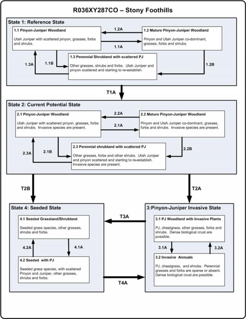
Pinyon-juniper sites were treated as one vegetation dynamic type when developing the provision ecological site initiative for MLRA 36. These sites will need to be altered as more data and knowledge in the future becomes available. Variability in climate, soils, aspect and complex biological processes will cause the plant communities to differ. These factors contributing to annual production variability include wildlife use, drought, and insects. Factors contributing to special variability include soil texture, depth, rock fragments, slope, aspect, and micro-topography. The species lists are representative and not a complete list of all occurring or potentially occurring species on this site. The species lists are not intended to cover the full range of conditions, species and responses of the site. The State & Transition model depicted for this site is based on available research, field observations and interpretations by experts and could change as knowledge increases. As more data is collected, some of these plant communities may be revised or removed, and new ones may be added. The following diagram does not necessarily depict all the transitions and states that this site may exhibit, but it does show some of the most common plant communities.
This state represents the natural variability and dynamics of this site that occurred naturally. This state includes the dominant biotic communities that would have occurred on this ecological site prior to European Settlement. The dominant aspect of this site is Pinyon and Utah Juniper with an understory of shrubs and associated grasses. Fluctuations in species compositions and relative production may change from year to year dependent upon abnormal precipitation or other climatic factors. The primary disturbance mechanisms for this site in reference condition include drought, insects, and infrequent fire. Because catastrophic disturbances like a crown fire or drought happen with long intervals, these communities have long periods of succession, (i.e. long periods of dense Pinyon and Juniper)—300-600 years in upland/foothills ecological site zone and 300 to 1,000 in semi-desert ecological site zone. According to Shinneman (2006), the pinon-juniper zone on the Uncompahgre Plateau typically burns in high-intensity, stand-replacing fires with a 400–600 years rotation (Shinneman, 2006). In the semi-arid environment of this ecological site, fine fuels are typically not continuous, reducing the likelihood of short fire return intervals. Typically, fires occurred in late spring through mid-summer following several wet years that allowed the fine fuels to become more contiguous (Baisan and Swetnam, 1990, and Swetnam and Baisan, 1996). The higher in elevation and higher precipitation area would burn more frequently as they would have more fine fuels in the understory. The timing of drought, and fire, coupled with surface disturbance can dictate whether the community can stay within the reference state or if the community transitions into another state.
Community 1.1 Pinyon-Juniper Woodland
A well-developed understory with a canopy of younger Pinyon and Utah juniper. At this stage Utah juniper may be dominant over Pinyon. Pinyon trees are more susceptible to drought, insects, and disease than Utah Juniper trees. In fact, it is difficult to identify methods beside fire that naturally reduce Utah juniper. After long periods of drought weaken the Pinyon trees, beetle kills can become quite extensive, especially after the droughts. Drought periods can also weaken and reduce the understory. Plant establishment is mainly limited by the available moisture. Biological crusts can be highly developed and diversified in the large interspaces between trees.
Figure 8. Plant community growth curve (percent production by month). CO0103, MLRA 36 - Foothills Mesic. MLRA 36.
Jan
Feb
Mar
Apr
May
Jun
Jul
Aug
Sep
Oct
Nov
Dec
J
F
M
A
M
J
J
A
S
O
N
D
0
0
8
32
32
18
0
0
4
6
0
0
Community 1.2 Mature Pinyon-Juniper Woodland
Mature pinyon and Utah juniper woodland characterized this community phase. When weather patterns favor an increase of pinyon and Utah juniper canopy with the associated understory of shrubs, grasses and forbs. Depending on the timing of precipitation, cool season grasses, like Indian ricegrass or warm season grasses like galleta could be dominant. Interspaces supporting highly developed biological crusts are common.
Figure 9. Plant community growth curve (percent production by month). CO0103, MLRA 36 - Foothills Mesic. MLRA 36.
Jan
Feb
Mar
Apr
May
Jun
Jul
Aug
Sep
Oct
Nov
Dec
J
F
M
A
M
J
J
A
S
O
N
D
0
0
8
32
32
18
0
0
4
6
0
0
Community 1.3 Perennial Shrubland with Scattered Pinyon-Juniper
The overall aspect of this community phase is grasses and shrubs with scattered pinyon and Utah juniper. The herbaceous understory has a mix of grasses and forbs. This community phase is a result of a crown fire or sufficiently large and hot ground fire that will kill many of the trees, combined with sufficient seed-banks and moisture for reestablishment of grasses and forbs. It is common that after a crown fire many patches of trees will remain unburned, because of fire’s unpredictability and broken topography. This leaves a seed bank for the burned areas. This community phase is very short lived in comparison to the other community phases in this state.
The following is from the 1975 Range site:
This community is approximately 50-75% grasses, 5-10% forbs, 15-30% shrubs, and 5-10% trees.
This site is a grassland plant community with small amounts of shrubs, pinyon pine, and Utah juniper. Grasses such as Indian ricegrass, native bunch bluegrasses, needle-and-thread, galleta, blue grama, Junegrass, squirreltail, and wheatgrasses make up the major part of the plant cover. Pinyon and juniper are generally present. Browse plants include big sagebrush, mountain mahogany, serviceberry, Mormon tea, and bitterbrush. Many of the forbs such as daisies, asters, eriogonums, stemless goldenweed, phlox, penstemon, and herbaceous sage are associated in the composition. Sites having 10% or more crown canopy of pinyon and/or juniper are woodland sites.
Tree species native to this site are pinyon and juniper. Canopy does not exceed 10 percent.
Optimum ground cover is 25 percent.
Invaders of this site are gumweed, sleepy grass, and annual plants.
Optimum ground cover is 25%.
Invaders of this site are gumweed, sleepy grass, and annual plants.
Total Annual Production:
Favorable years 800 lbs/ac air dry
Unfavorable years 400 lbs/ac air dry
Median years 600 lbs/ac air dry
Figure 10. Annual production by plant type (representative values) or group (midpoint values)
Table 5. Annual production by plant type
Plant type
Low (lb/acre)
Representative value (lb/acre)
High (lb/acre)
Grass/Grasslike
240
320
410
Tree
70
120
150
Shrub/Vine
50
100
150
Forb
40
60
90
Total
400
600
800
Figure 11. Plant community growth curve (percent production by month). CO0103, MLRA 36 - Foothills Mesic. MLRA 36.
Jan
Feb
Mar
Apr
May
Jun
Jul
Aug
Sep
Oct
Nov
Dec
J
F
M
A
M
J
J
A
S
O
N
D
0
0
8
32
32
18
0
0
4
6
0
0
Pathway 1.1A Community 1.1 to 1.2
This pathway occurs when events create a wetter climate cycle, favor pinyon and perennial bunch grass establishment. Following several favorable precipitation years and lack of surface disturbances, native perennial plants will reestablish.
Pathway 1.1B Community 1.1 to 1.3
This pathway is very unlikely, but can occur when a fire is able to move through the community. Two situations can make this occur: 1) a fire can carry in the understory after several wet years allow fine fuels to accumulate, or 2) as the woodland approaches the later stages of development where canopies become dense and crown sizes have increased, and thus community phase becomes susceptible to crown fires.
Pathway 1.2A Community 1.2 to 1.1
This pathway occurs during and after events such as drought or insect/pathogen outbreaks. Droughts and insects can kill the trees, increasing nutrient availability in the system. Due to the natural conditions of drought, grasses typically do not take up the extra nutrients in the long term. In the short term, grasses and forbs may increase for a few years until juniper and pinyon recover.
Pathway 1.2B Community 1.2 to 1.3
This pathway is very unlikely but can occur when a fire is able to move through the community phase. Two situations can make this occur: 1) a fire can carry in the understory after several wet years allow fine fuels to accumulate, or 2) as the woodland approaches the later stages of development where canopies become dense and crown sizes have increased, and thus community phase becomes susceptible to crown fires.
Pathway 1.3A Community 1.3 to 1.1
This pathway occurs when the climate favors the establishment and growth of trees. More energy is taken-up and stored in the trees as the length between fires and droughts increase. In addition, when shrubs establish on the site they can provide safe-sites for tree establishment furthering the presence of trees.
State 2 Current Potential
This state is very similar to the reference state, except that non-native grasses and/or forbs are now present in all community phases. The current potential state may include introduced (seeded) or invasive nonnative species. The invasive plants are present in sparse amounts in this state. Natural disturbance are still drought, insects, and infrequent fires still influence the community shifts. The human caused disturbance drivers (i.e. domestic livestock grazing, vegetation manipulation, and recreational activities (i.e. OHV use)) are now present. This shift in species composition could affect nutrient cycling, hydrology and soil stability. At this time there is no known way to effectively remove the non-native plants from the site once they have become established. State 2 is in jeopardy of moving to State 3 (Pinyon-Juniper Invasive State) when remaining native understory plants are stressed and invasive species have increased till they are dominant.
Community 2.1 Pinyon-Juniper Woodland
A well-developed understory with a canopy of younger Pinyon and Utah juniper. At this stage Utah juniper may be dominant over Pinyon. Pinyon trees are more susceptible to drought, insects, and disease than Utah Juniper trees. In fact, it is difficult to identify methods beside fire that naturally reduce Utah juniper. After long periods of drought weaken the Pinyon trees, beetle kills can become quite extensive, especially after the droughts. Drought periods can also weaken and reduce the understory. Plant establishment is mainly limited by the available moisture. Biological crusts can be highly developed and diversified in the large interspaces between trees. Sparse invasive introduced plants species would be present in this phase.
Community 2.2 Mature Pinyon-Juniper Woodland
Mature pinyon and Utah juniper woodland with a well-developed understory would characterized this community phase. This phase supports a diverse understory of grasses, forbs and shrubs. Depending on the timing of precipitation, cool season grasses, like Indian ricegrass or warm season grasses like galleta could be dominant. Interspaces supporting highly developed biological crusts are common. Sparse invasive introduced plants species would be present in this phase.
Community 2.3 Perennial Shrubland with Scattered Pinyon-Juniper
The overall aspect of this community phase is grassland with scattered pinyon and Utah juniper. The herbaceous understory has a mix of grasses and forbs. This community phase is a result of a crown fire or sufficiently large and hot ground fire that will kill many of the trees, combined with sufficient seed-banks and moisture for reestablishment of grasses and forbs. It is common that after a crown fire many patches of trees will remain unburned, because of fire’s unpredictability and broken topography. This leaves a seed bank for the burned areas. This community phase is very short lived in comparison to the other community phases in this state. Sparse invasive introduced plants species would be present in this phase.
Pathway 2.1A Community 2.1 to 2.2
This pathway occurs when events create a wetter climate cycle, favor Pinyon and perennial bunch grass establishment. Following several favorable precipitation years and lack of surface disturbances, native perennial bunch grasses and forbs will reestablish.
Pathway 2.1B Community 2.1 to 2.3
This pathway is very unlikely, but can occur when a fire or vegetation manipulation happens to the trees. Two situations can make this occur: 1) a fire can carry in the understory after several wet years allow fine fuels to accumulate, or 2) as the woodland approaches the later stages of development where canopies become dense and crown sizes have increased, and thus community phase becomes susceptible to crown fires. Seeding after the tree removal may be necessary to help facilitate the return of understory species. Seeding depending on the species may take this community phase into state 4 (Seeded State).
Pathway 2.2A Community 2.2 to 2.1
This pathway occurs during and after events such as drought or beetle infestations. Droughts and insects can kill pinyon trees, increasing nutrient availability in the system. Due to the natural conditions of drought, grasses typically do not take up the extra nutrients in the long term. In the short term, grasses and forbs may increase for a few years until Juniper recover. Utah Juniper are more able to compete for these nutrients and became the dominant overstory tree over time.
Pathway 2.2B Community 2.2 to 2.3
This pathway is very unlikely to occur naturally with fire. But, vegetation manipulation can be used to remove trees. Two situations occur naturally: 1) a fire can carry in the understory after several wet years allow fine fuels to accumulate, or 2) as the woodland approaches the later stages of development where canopies become dense and crown sizes have increased, and thus community phase becomes susceptible to crown fires. Seeding after the tree removal may be necessary to help facilitate the return of understory species. Seeding depending on the species may take this community phase into state 4 (Seeded State).
Pathway 2.3A Community 2.3 to 2.1
This pathway occurs when the climate favors the establishment and growth of trees. More energy is taken-up and stored in the trees as the length between fires and droughts increase. In addition, when shrubs establish on the site they can provide safe-sites for tree establishment furthering the presence of trees.
State 3 Pinyon-Juniper Invasive
This state occurs when there is an absence of natural disturbance (i.e. Insects and drought and/or fire) over long time frames (Zlatnik, 1999). Also, management actions could have allowed trees to become very mature and have effectively closed out the understory. Invasive plants have increased in abundance. This state has the lowest resiliency and resistance of any state in this model. There may be no practicable way back to the Current Potential State (State 2), due to the large amounts of energy and monetary inputs that are needed. Seeding, with either natural disturbance and/or vegetation management to transition it to State 3 (Seeded State) may be the best long term option for this site.
Community 3.1 Pinyon-Juniper Woodland with Invasive Plants
A lack of understory with a canopy of older Pinyon and Juniper, where plant interspaces very large and connected. This community phase occurs when natural or management actions allow for the increase in Pinyon and Utah juniper and a decrease in the grass and forb understory. Invasive introduced plants species would be present in this phase and are increasing.
Figure 12. Plant community growth curve (percent production by month). CO0103, MLRA 36 - Foothills Mesic. MLRA 36.
Jan
Feb
Mar
Apr
May
Jun
Jul
Aug
Sep
Oct
Nov
Dec
J
F
M
A
M
J
J
A
S
O
N
D
0
0
8
32
32
18
0
0
4
6
0
0
Community 3.2 Invasive Annuals
This state is characterized by annual grasses like cheatgrass, annual wheatgrass dominating the understory. Also, invasive forbs like storkbill, halogeton and others may be present. This community phase has active erosion under the pinyon and Utah juniper canopy. Utah Juniper has allelopathic effects on some plant (i.e. Sandberg bluegrass, blue grama), which cheatgrass does not appear to suffer this effect when growing under juniper canopies (Zlatnik, 1999).
Figure 13. Plant community growth curve (percent production by month). CO0103, MLRA 36 - Foothills Mesic. MLRA 36.
Jan
Feb
Mar
Apr
May
Jun
Jul
Aug
Sep
Oct
Nov
Dec
J
F
M
A
M
J
J
A
S
O
N
D
0
0
8
32
32
18
0
0
4
6
0
0
Pathway 3.1A Community 3.1 to 3.2
This pathway occurs when events such as frequent fire or drought remove the trees and shrubs, and facilitate the continued establishment of cheatgrass or other invasive annuals. Cheatgrass will typically invade/increase in tree/shrub interspaces when PJ communities are degraded. Once the cheatgrass establishes the amount and continuity of fine fuels increases. This can reduce the fire return interval and shorten the time between fires. When fire eliminates the tree/shrub/native grass component, it completes the conversion to annual dominant community phase. Cheatgrass and other invasive annuals can persist for long periods of time. Once a fire or a drought removes the trees/shrubs, it is difficult to reestablish because, not only has the fire return interval been shortened to a time that will not allow seedling establish, the soil and other abiotic factors have been altered.
Pathway 3.2A Community 3.2 to 3.1
This pathway is when there is a lack of fire and/or disturbance. The fire return interval lengthens. This could be done by having firebreaks and/or fire suppression which will allow the perennial species a chance to establish with natural processes or with vegetation manipulation.
State 4 Seeded
This state is a result seeding plants species. Vegetation manipulation may or may not have been done depending on disturbance history of the location. The trees were removed and adapted grasses, forbs and shrubs are established. Plants can be native or introduced depending on the desired management goals. If grazing tolerant species were established these communities can better withstand grazing and other disturbances. Due to the shallow or rocky soils and unpredictable precipitations patterns, it is difficult to establish grasses from seed, so this state may be hard to achieve and require large energy inputs.
Community 4.1 Seeded Grassland and Shrubland
This community phase appears as a grassland with scattered shrubs and trees. The vegetative production is typically higher than in the current potential state, depending on grass species seeded; however the grass is still sparse due to the low water holding capacity of soils associated with pinyon and juniper.
Figure 14. Plant community growth curve (percent production by month). CO0103, MLRA 36 - Foothills Mesic. MLRA 36.
Jan
Feb
Mar
Apr
May
Jun
Jul
Aug
Sep
Oct
Nov
Dec
J
F
M
A
M
J
J
A
S
O
N
D
0
0
8
32
32
18
0
0
4
6
0
0
Community 4.2 Seeded with Pinyon-Juniper
This community phase has a dense under story of introduced grasses and forbs, but a canopy of pinyon and Utah juniper are establishing. Native perennial grasses, forbs, and shrubs may also be starting to establish. Interspaces are filled with biological crusts and herbaceous plants.
Figure 15. Plant community growth curve (percent production by month). CO0103, MLRA 36 - Foothills Mesic. MLRA 36.
Jan
Feb
Mar
Apr
May
Jun
Jul
Aug
Sep
Oct
Nov
Dec
J
F
M
A
M
J
J
A
S
O
N
D
0
0
8
32
32
18
0
0
4
6
0
0
Pathway 4.1A Community 4.1 to 4.2
This pathway occurs when events favor the establishment of shrubs and trees, including long periods without disturbances.
Pathway 4.2A Community 4.2 to 4.1
This pathway occurs as trees and shrubs are removed from the community, either naturally through insect herbivory or through vegetation manipulation by man.
Transition T1A State 1 to 2
This transition from the native perennial bunchgrass and shrub understory in the reference state to a state that has been invaded by naturalized species such as crested wheatgrass (blown in or seeded), cheatgrass, annual wheatgrass and other introduced or exotic plants. This transition occurs as natural and/or management actions favor an increase in non-native grasses and forbs, especially annuals. Possible events include the presence of invasive species, improper livestock grazing, extended droughts, and fire combined with an available seed source of non-native species.
Transition T2A State 2 to 3
When this transition to state 3 occurs the site has lost much of its expected resistance and resilience. At this point natural and/or management actions have decreased the understory to a point where erosion increases. Reduced influence from fire, insects, and drought could cause the tree canopy to close, effectively reducing the herbaceous understory thus facilitating the transition. Improper grazing and or increase surface disturbance combined with periods of drought can facilitate this transition because soil stability is lost and susceptibility to soil loss increases.
Transition T2B State 2 to 4
This transition is from tree canopy reduction and re-establishment of grasses and forbs. If the community is approaching state 3 (pinyon-juniper invasive state), due to a loss of understory and increase invasive plants this pathway of seeding could be preferable to doing nothing. This pathway may facilitate the recovery of the soils. The infrequent naturally occurring fires could also cause this transition. Reseeding after a fire may be the only way to successfully restore the ecological dynamics to a site. Either way this pathway involves large energy and monetary inputs by man.
Transition T3A State 3 to 4
Vegetation treatment can transition it to a seeded state. Because of the soils (shallow and/or rocky) and the unpredictable precipitation, this pathway should be used cautiously. This pathway involves large energy and monetary inputs by man.
Transition T4A State 4 to 3
This transition occurs when events favor the establishment and dominance of invasive annuals. Events may include an extended drought, surface disturbance such as off road vehicle use, and/or a shortened fire return interval, all of which can stress the native perennial bunchgrasses.
Additional community tables
Table 6. Community 1.3 plant community composition
WILDLIFE INTERPRETATIONS:
This site provides a high value rating for deer, cottontail, jackrabbit, and upland game birds. It provides medium value for antelope and low value for elk.
The following is from 1975 Range Site:
GRAZING INTERPRETATIONS:
This site provides a medium value rating for cattle, sheep, and horses.
Hydrological functions
Soils were originally assigned to hydrologic soil groups based on measured rainfall, runoff, and infiltrometer data (Musgrave 1955). Since the initial work was done to establish these groupings, assignment of soils to hydrologic soil groups has been based on the judgment of soil scientists. Assignments are made based on comparison of the characteristics of unclassified soil profiles with profiles of soils already placed into hydrologic soil groups. Most of the groupings are based on the premise that soils found within a climatic region that are similar in depth to a restrictive layer or water table, transmission rate of water, texture, structure, and degree of swelling when saturated, will have similar runoff responses. Four (4) Hydrologic Soil Groups are recognized (A-D). For specific definitions of each hydrologic soil group see the National Engineering Handbook, Chapter 7, Part 630 Hydrology, or visit:http://policy.nrcs.usda.gov/OpenNonWebContent.aspx? content=22526.wba The hydrologic soil groups are based on the following factors:
-intake and transmission of water under the conditions of maximum yearly wetness (thoroughly wet)
- soil not frozen
- bare soil surface
- maximum swelling of expansive clays
The slope of the soil surface is not considered when assigning hydrologic soil groups. In its simplest form, the hydrologic soil group is determined by the water transmitting soil layer with the lowest saturated hydraulic conductivity and depth to any layer that is more or less water impermeable (such as a fragipan or duripan) or depth to a water table (if present) (Caudle, et. al, 2013). The runoff curve numbers are determined by field investigations using hydrologic cover conditions and hydrologic soil groups.
Soils Hydrologic Group
Loamy-Skeletal Soils
Signalhill - C
Clayey-Skeletal
Wellsbasin - C
Hydrologic soil groups are based on estimates of runoff potential. Soils are assigned to one of four groups according to the rate of water infiltration when the soils are not protected by vegetation, are thoroughly wet, and receive precipitation from long-duration storms (Soil Survey Staff, 2015).
The soils in the United States are assigned to four groups (A, B, C, and D) and three dual classes (A/D, B/D, and C/D). The groups are defined as follows:
Group A. Soils having a high infiltration rate (low runoff potential) when thoroughly wet. These consist mainly of deep, well drained to excessively drained sands or gravelly sands. These soils have a high rate of water transmission.
Group B. Soils having a moderate infiltration rate when thoroughly wet. These consist chiefly of moderately deep or deep, moderately well drained or well drained soils that have moderately fine texture to moderately coarse texture. These soils have a moderate rate of water transmission.
Group C. Soils having a slow infiltration rate when thoroughly wet. These consist chiefly of soils having a layer that impedes the downward movement of water or soils of moderately fine texture or fine texture. These soils have a slow rate of water transmission.
Group D. Soils having a very slow infiltration rate (high runoff potential) when thoroughly wet. These consist chiefly of clays that have a high shrink-swell potential, soils that have a high water table, soils that have a claypan or clay layer at or near the surface, and soils that are shallow over nearly impervious material. These soils have a very slow rate of water transmission (Soil Survey Staff, 2015).
Recreational uses
The following is from 1975 Range Site:
Medium value rating.
Wood products
The following is from 1975 Range Site:
Low value rating.
Supporting information
Other references
Baisan, C. H. and T. W. Swetnam. 1990. Fire history on a desert mountain range: Rincon Mountain Wilderness, Arizona, USA. Canadian Journal of Forest Research. 20:1559-1569.
Betancourt, J. L., E. A. Pierson, K. A. Rylander, J. A. Fairchild-Parks, and J. S. Dean. 1993. Influence of history and climate on New Mexico pinyon-juniper woodlands. In: Gen. Tech. RM-236 - Managing Pinon-Juniper Ecosystems for Sustainability and Social Needs.
Cartledge, T. R., and J. G. Propper. 1993. Pinon-Juniper Ecosystems through Time: Information and Insights from the Past. In Gen. Tech. RM-236 - Managing Pinon-Juniper Ecosystems for Sustainability and Social Needs.
Floyd, M.L., W.H. Romme, and D.D. Hanna. 2000. Fire History and vegetation pattern in Mesa Verde National Park, Colorado, USA. Ecological Applications. 10:1666-1680.
Floyd, M. L., D. D. Hanna, W. H. Romme. 2004. Historical and recent fire regimes in pinyon-juniper woodlands on Mesa Verde, Colorado, USA. Forest Ecology and Management. 198:269-289.
Kennard, D.K. and A.J. Moore. 2013. Fire history, woodland structure, and mortality in pinon-juniper woodland in the Colorado National Monument. Natural Areas Journal. 33:296-306.
Miller, R. F. and R. J. Tausch. 2001. The role of fire in juniper and pinyon woodlands: a descriptive analysis. In: Galley, K.E.M.; Wilson. T.P., [EDs]. Proceedings of the invasive species workshop: the role of fire in the control and spread on invasive species. Fire conference 2000. Tallahassee, Fl: Tall Timbers Research Station: Miscellaneous publication 11:15-30.
Miller, R. F. and J. A. Rose. 1999. Fire history and western juniper encroachment in sagebrush steppe. Journal of Range Management. 52:550-559.
Musgrave, G.W. 1955. How much of the rain enters the soil? In Water: U.S. Department of Agriculture Yearbook. Washington, D.C. P. 151- 159.
Passey, H. B., W. K. Hugie, E. W. Williams, and D. E. Ball. 1982. Relationships between soil, plant community, and climate on rangelands of the Intermountain west. USDA, Soil Conservation Service, Tech. Bull. No. 1669.
Romme, W. H., C.D. Allen, J.D. Bailey, W.L. Baker, B.T. Bestelmeyer, P.M. Brown, K.S. Eisenhart, M.L. Floyd, D.W. Huffman, B.F. Jacobs, R.F. Miller, E.H. Muldavin, T.W. Swetnam, R.J. Tausch, and P.J. Weisberg. 2009. Historical and Modern Disturbance Regimes, Stand Structures, and Landscape Dynamics in Pinon-Juniper Vegetation of the Western United States. Rangeland Ecology and Management 62:203-222.
Shinneman, D. J. and W. L, Baker. 2009. Historical fir and multidecadal drought as context for pinon-juniper woodland restoration in western Colorado. Ecological Applications 19: 1231-1245.
Soil Conservation Service (SCS). August 1975. Range Site Description for Clayey Foothills #289: USDA, Denver Colorado
Soil Survey Staff, Natural Resources Conservation Service, United States Department of Agriculture. Web Soil Survey. Available online at http://websoilsurvey.nrcs.usda.gov/. Accessed [5/3/2017].
Swetnam, T. and Baisan, C. 1996. Historical fire regime patterns in the southwestern United States since AD 1700. In: CD Allen (ed.) Fire Effects in Southwestern Forest: Proceedings of the 2nd La Mesa Fire Symposium, pp. 11-32. USDA Forest Service, Rocky Mountain Research Station, General Technical Report RM-GTR-286.
Tausch, R. J., N. E. West, and A. A. Nabi. 1981. Tree age and dominance patterns in Great Basin pinyon-juniper woodlands. Journal of Rangeland Management 34:259-264.
Zlatnik, E. 1999. Juniperus osteosperma. In: Fire Effects Information System. U.S. Department of Agriculture, Forest Service, Rocky Mountain Research Station, Fire Sciences Laboratory (Producer). http://www.fs.fed.us/database/feis/. Accessed March 27, 2017.
Contributors
Suzanne Mayne Kinney
Approval
Kirt Walstad, 12/20/2024
Acknowledgments
Project Staff:
Suzanne Mayne-Kinney, Ecological Site Specialist, NRCS MLRA, Grand Junction SSO
Chuck Peacock, MLRA Soil Survey Leader, NRCS MLRA Grand Junction SSO
Program Support:
Rachel Murph, NRCS CO State Rangeland Management Specialist, Denver
Scott Woodhall, NRCS MLRA Ecological Site Specialist-QA Phoenix, AZ
Eva Muller, Regional Director, Rocky Mountain Regional Soil Survey Office, Bozeman, MT
B.J. Shoup, CO State Soil Scientist, Denver
Eugene Backhaus, CO State Resource Conservationist, Denver
Partners/Contributors:
Those involved in developing earlier versions of this site description include: Herman Garcia, retired CO State RMS and NRCS MLRA Ecological Site Specialist-QA Phoenix, AZ.
--Site Development and Testing Plan--:
Future work to validate and further refine the information in this Provisional Ecological Site Description is necessary. This will include field activities to collect low-, medium-, and high-intensity sampling, soil correlations, and analysis of that data.
Additional information and data is required to refine the Plant Production and Annual Production tables for this ecological site. The extent of MLRA 36 must be further investigated.
Field testing of the information contained in this Provisional ESD is required. As this ESD is moved to the Approved ESD level, reviews from the technical team, quality control, quality assurance, and peers will be conducted.
Rangeland health reference sheet
Interpreting Indicators of Rangeland Health is a qualitative assessment protocol used to
determine ecosystem condition based on benchmark characteristics described in the Reference Sheet. A suite of 17 (or
more) indicators are typically considered in an assessment. The ecological site(s) representative of an assessment
location must be known prior to applying the protocol and must be verified based on soils and climate. Current plant
community cannot be used to identify the ecological site.
Author(s)/participant(s)
Suzanne Mayne-Kinney
Contact for lead author
Date
05/19/2017
Approved by
Kirt Walstad
Approval date
Composition (Indicators 10 and 12) based on
Annual Production
Indicators
Number and extent of rills:
Some rills are inherent to the site. They are common and are short and disconnected due to the rock fragments on the soil surface. In exposed areas, rills may be 6 to 10 feet in length.
Presence of water flow patterns:
Water flow patterns are expected. They frequently form around rock fragments and plant bases. Usually, they tend to be short and disconnected with debris dams. The areas between the rocks, plants and cryptogams may serve as small areas where water will pool, until it infiltrates the soil. As slopes get steeper, flow paths are more frequent and evident, runoff is more rapid. Intense summer storms can cause water flow patterns to be more evident after storms.
Number and height of erosional pedestals or terracettes:
Short pedestals are expected at the base of the plants, there should not be exposed roots. When a large amount of well-developed biological crusts present, they can give the appearance of being pedestals. Terracettes and/or debris dams can form in the smaller water flow patterns.
Bare ground from Ecological Site Description or other studies (rock, litter, lichen, moss, plant canopy are
not bare ground):
Expect 10-20% bare ground. Soil surface is typically covered 15 to 65 percent surface fragments.
Number of gullies and erosion associated with gullies:
None to few. On steeper slopes and areas below and adjacent to sites with concentrated water flow (such as exposed bedrock), gullies may increase. Length is short and is usually interrupted by large rock fragments. Gullies are shallow and wide and armored with large stones. Gullies may remove soil from the base of trees exposing roots.
Extent of wind scoured, blowouts and/or depositional areas:
None. The trees and shrubs on this site generally intercept the wind and prevent most wind generated soil erosion. Also, rock fragments present on this site helps to reduce the potential for wind erosion.
Amount of litter movement (describe size and distance expected to travel):
Litter for the most part stays in place. There can be some redistribution by water movement of the fine litter in the rills and water patterns. Most litter accumulates at the base of the plants on this site. Woody litter movement on this site is unusual. Litter movement is more evident on the steeper slopes and also, may be greater following intensive rainstorms.
Soil surface (top few mm) resistance to erosion (stability values are averages - most sites will show a range
of values):
This site should have an erosion rating of 3 to 5 under the plant canopies, and a rating of 2 to 4 in the interspaces. The average should be a 3 or 4. Vegetation cover, litter, biological soil crusts and surface rock reduce erosion. This site can have cryptogamic crusts which help to stabilize the soil surface.
Soil surface structure and SOM content (include type of structure and A-horizon color and thickness):
Soil organic matter content ranges from 0.5-2%. Soils are moderately deep to deep in depth. The surface soils of this site range from very cobbly/very gravelly loam, and stony loam. Soils are filled with gravels, cobbly, channery and/or stone filled. Soil structure is weak medium and fine subangular blocky structure parting to weak fine granular. The soil surface (A horizon) ranges from 3 to 14 inches in depth. Refer to soil survey for more detailed information about your specific site.
Effect of community phase composition (relative proportion of different functional groups) and spatial
distribution on infiltration and runoff:
The presence of trees, perennial grasses and forbs, and shrubs will breakup raindrop impact and splash erosion. The spatial distribution of the plants, biological crusts and interspaces will provide small pockets for water storage and surface roughness that slows down runoff, allowing time for infiltration. The tree and shrub canopy is effective in intercepting rain drops and preventing splash erosion on the reference state. But, with increased tree canopy, understory canopy is reduced, increased bare soil and litter accumulates under trees, it can forms micro-topography that can help water accumulate which can cause more rapid runoff.
Presence and thickness of compaction layer (usually none; describe soil profile features which may be
mistaken for compaction on this site):
None. There may be layers of calcium carbonate or other naturally occurring hard layers found in the soil subsurface. These should not be considered to be compaction layers.
Functional/Structural Groups (list in order of descending dominance by above-ground annual-production or live foliar
cover using symbols: >>, >, = to indicate much greater than, greater than, and equal to):
warm season short bunchgrass (Galleta) >cool season rhizomatous (Western wheatgrass) > cryptogams
Additional:
Amount of plant mortality and decadence (include which functional groups are expected to show mortality or
decadence):
A mix of young, middle aged and old pinyon and Utah juniper are expected to be found on this site. In years with average or above average precipitation, shrubs, grasses and forbs should have little mortality or decadence. Tree mortality, especially pinyon, can be expected under severe and/or extended drought and subsequent insect infestations. Under a dense tree canopy, understory has increased decadence and mortality.
Average percent litter cover (%) and depth ( in):
15-30% litter cover at 0.25-2.0 inch depth, depending upon tree canopy. Most litter is at the base and under the canopy of the plants.
Expected annual annual-production (this is TOTAL above-ground annual-production, not just forage annual-production):
400 lbs. /ac. low precipitation years, 600 lbs. /ac. average precipitation years, 800 lbs. /ac. above average precipitation years. After extended drought or the first growing season following wildfire, production may be significantly reduced by 200 - 350 lbs. /ac. or more.
Potential invasive (including noxious) species (native and non-native). List species which BOTH characterize
degraded states and have the potential to become a dominant or co-dominant species on the ecological site if
their future establishment and growth is not actively controlled by management interventions. Species that become
dominant for only one to several years (e.g., short-term response to drought or wildfire) are not invasive
plants. Note that unlike other indicators, we are describing what is NOT expected in the reference state for the
ecological site:
Cheatgrass, annual weeds, other noxious weeds.
Perennial plant reproductive capability:
All plants have the ability to reproduce in most years. Limitations are weather related, wildfire, natural disease, inter-species competition, and insects may temporarily reduce reproductive capability. Increased tree canopy will result in decreased understory reproductive capability.
The Ecosystem Dynamics Interpretive Tool is an information system framework developed by the USDA-ARS Jornada Experimental Range, USDA Natural Resources Conservation Service, and New Mexico State University.
Click on box and path labels to scroll to the respective text.