Provisional. A provisional ecological site description has undergone quality control and quality assurance review. It contains a working state and transition model and enough information to identify the ecological site.
Areas shown in blue indicate the maximum mapped extent of this ecological site. Other ecological sites likely occur within the highlighted areas. It is also possible for this ecological site to occur outside of highlighted areas if detailed soil survey has not been completed or recently updated.
MLRA notes
Major Land Resource Area (MLRA): 046X–Northern and Central Rocky Mountain Foothills
Major Land Resource Area (MLRA): 046X–Northern Rocky Mountain Foothills
Major Land Resource Area (MLRA) 46, Rocky Mountain Foothills, is approximately 11.6 million acres. MLRA 46’s extent has changed over recent years and is now primarily located in Montana and Wyoming with limited acres in Utah and Colorado. It spans from the Canadian border south to the Uinta Mountains of Northwest Colorado. MLRA 46 is a transitional MLRA between the plains and mountains of primarily non-forested rangeland. In Montana, 3 Land Resource Units (LRUs) exist based on differences in geology, landscape, soils, water resources, and plant communities. Elevations for this MLRA in Montana vary from a low of 3200 feet to 6500 feet (975-1981m) however the elevations on the fringes of this MLRA may fall outside of that range in extremely small isolated areas where the boundaries between neighboring MLRAs are not easily defined. Annual precipitation ranges from 8 inches (254mm) to, in very isolated areas, 42 inches (1083mm). In general precipitation rarely exceeds 24 inches (610mm). Frost Free Days are variable from 50 days near the Crazy and Beartooth Mountains to 130 days in the foothills south of the Bear’s Paw Mountains of Central Montana. The geology of MLRA 46 is generally Cretaceous and Jurassic marine sediments.
MLRA 46’s plant communities are dominated by cool season bunchgrasses with mixed shrubs. This MLRA is rarely forested however Ponderosa and limber pine do occupy areas. Portions of this MRLA may have a sub dominance of warm season mid-statured bunchgrasses like little bluestem, however the general concept of the MLRA does not have a large component of warm season species. Wyoming big sagebrush, mountain big sagebrush, silver sagebrush, common snowberry, and shrubby cinquefoil tend to be the dominant shrub component. The kind and presences of shrubs tends to be driven by a combination of soils and climate. Due to the variable nature of the Land Resources Units, Climatic subsets will be necessary to describe the ecological sites and the variation of plant communities for this MLRA.
LRU notes
The Rocky Mountain Front Foothills LRU is the northernmost LRU of MLRA 46. The boundaries are the Canadian border to the north, MRLA 43B and the western extent of Continental Glaciation (MLRA 52). Boundaries between these MLRAs are extremely broad and often hard to distinguish.
Major watersheds of this LRU include the Missouri River, Sun River, Teton River, Marias River, and the Milk River. All of these river systems have been modified for the purpose of irrigation of pasture and crops.
The Rocky Mountain Front Foothills LRU’s geology is generally sedimentary in nature. Primary geological units include Two Medicine Limestone & Sandstone, Colorado Shale, Glacial Drift (alluvium), Terrace deposits (alluvium) and St Mary River formation (mudstone). Landforms include outwash terraces, escarpments, fan remnants, valleys, hillslopes, and drainage ways. Elevations of this landscape is from 3221 feet (982m) to 6954 feet (2120m).
Well drained soils are dominate in this LRU. Most areas vary from nearly level to 15 percent slope, while some areas do express steeper slopes near the 43B boundary. Soils are Slight to Moderate Alkaline. Soil mean clay percentages are mostly above 23 percent and are primarily very deep at approximately 70 percent of the LRU and moderately-deep to deep soils at approximately 30 percent of the LRU.
The climate of this LRU is highly variable however the average of 16.9 inches (429mm) follows the typical MLRA concept. The major difference between this LRU and the others of MLRA 46 is the Chinook wind. These winds create massive temperature swings in the winter which can melt snow cover and initiate bud growth on shrubs. These changes may dry soil affecting plant production and species composition. The Rocky Mountain Front Foothills receives 10 inches (247mm) to 42 inches (1083mm) annually. However 42 inches is extremely limited extent. The average air temperature ranges from 36 degrees Fahrenheit (2.39°C) to 46 degrees Fahrenheit (8.02°C). The soil temperature regime is frigid with a soil moisture regime dominated by Ustic with areas of Udic. Average Frost free days is from 70 to 117 days.
The vegetation potential for the Rocky Mountain Front Foothills LRU can be variable but is dominated by rangeland. Forested extents are typically minimal and consist primarily of Douglas fir, limber pine, ponderosa pine, and Rocky Mountain juniper with mixed grassland understory. The rangeland of this LRU follows the general concept of the MLRA. The dryer sites are dominated by bluebunch wheatgrass and as the precipitation increases and temperatures decrease rough fescue increases. In areas that receive the highest precipitation, Columbia and Richardson’s needlegrass may exist. Shrub cover is limited in this area and is generally silver sagebrush and shrubby cinquefoil with areas of chokecherry and buffaloberry (both Russet and silver). The glacial drift areas will often have wetland associated vegetation in potholes as well as large areas of quaking aspen with mixed meadows.
Conversion from rangeland to cropland has been the largest land use change of this relatively intact grassland system. Small grain (barley and wheat) production is the most common crop produced in this area. Forage crops such as hay barley, perennial grass pasture, and alfalfa hay are also common. Irrigation from the area's extensive water resources facilitates highly productive farming practices.
MLRA 46 has experienced high conversion from rangeland to urban development where larger expanses of land have been separated into smaller ranchette subdivisions. Often these ranchettes experience extremely high grazing pressure from companion animals.
Classification relationships
EPA Ecoregion Level III: Canadian Rockies
Level IV: Northern Front
Southern Carbonate Front
• Site does not receive any additional water
• Site slope is less than 15 percent
• Soils are
o Not saline or saline-sodic
o Moderately deep, deep, or very deep
o Clay content is < 32% in surface mineral 4”.
o Site does not have an argillic horizon with greater than 35 percent clay.
o Typically less than 5 percent stone and boulder cover (15 percent max)
o Not Skeletal (less than 35 percent rock fragments) at 10-20 inch control section
o Not strongly or violently effervescent within surface mineral 4 inches
• Soil surface texture ranges from sandy loam to clay loam in surface mineral 4 inches
• An area of dissected mountain valleys. The valleys are typically bordered by mountains trending north to south.
• Parent material is alluvium and colluvium (limited extent)
This ecological site occurs on nearly
level to strongly sloping plains, terraces, hills and fans. The slopes range from 0–15%, but are mainly less than 8%. This site occurs
on all exposures. Aspect is not significant. The depth to a water table (if one occurs) is greater than 40 inches.
Table 2. Representative physiographic features
Landforms
(1) Plain (2) Terrace (3) Hill
Flooding frequency
None to very rare
Ponding frequency
None
Slope
15%
Ponding depth
Not specified
Water table depth
40–60 in
Aspect
Aspect is not a significant factor
Climatic features
See Climatic Data Sheet for more details (Section II of the Field Office Technical Guide) or reference the following climatic web site: http://www.wrcc.sage.dri.edu/.
Table 3. Representative climatic features
Frost-free period (characteristic range)
57-84 days
Freeze-free period (characteristic range)
109-120 days
Precipitation total (characteristic range)
15-17 in
Frost-free period (actual range)
37-90 days
Freeze-free period (actual range)
101-122 days
Precipitation total (actual range)
14-17 in
Frost-free period (average)
69 days
Freeze-free period (average)
114 days
Precipitation total (average)
16 in
Characteristic range
Actual range
Bar
Line
Figure 2. Monthly precipitation range
Characteristic range
Actual range
Bar
Line
Figure 3. Monthly minimum temperature range
Characteristic range
Actual range
Bar
Line
Figure 4. Monthly maximum temperature range
Bar
Line
Figure 5. Monthly average minimum and maximum temperature
Figure 6. Annual precipitation pattern
Figure 7. Annual average temperature pattern
Climate stations used
(1) BABB 6 NE [USC00240392], Babb, MT
(2) AUGUSTA [USC00240364], Augusta, MT
(3) CASCADE 5 S [USC00241552], Cascade, MT
(4) ROGERS PASS 9 NNE [USC00247159], Wolf Creek, MT
Influencing water features
Soil features
These soils are loams, silt loams, very fine sandy loams, light clay loams and silty clay loams (< 34% clay in the surface horizon) or sandy clay loams more than 20 inches deep. They include soils that have two inches or more of one of these textures over a clayey (argillic) subsoil. There are no significant limitations to plant growth.
Parent material kinds can include alluvium, colluvium, residuum or eolian deposits.
Table 4. Representative soil features
Surface texture
(1) Loam
(2) Silt loam
(3) Very fine sandy loam
Drainage class
Moderately well drained to well drained
Permeability class
Moderately slow to moderate
Soil depth
20–60 in
Available water capacity (0-40in)
5–8 in
Electrical conductivity (0-40in)
Not specified
Sodium adsorption ratio (0-40in)
Not specified
Soil reaction (1:1 water) (0-40in)
6.6–8.4
Subsurface fragment volume <=3" (Depth not specified)
10%
Subsurface fragment volume >3" (Depth not specified)
5%
Ecological dynamics
Following are descriptions of several plant communities that may occupy this site. The interpretive community described in the plant community tables is the Historical Climax Plant Community (HCPC). This community is represented by a level to rolling grassland dominated by cool season bunchgrasses, with several species of forbs occurring in small percentages. Minor variations in the plant community will occur as an expression of climatic patterns, topography and landform, elevation, soils, fire pattern and history, and grazing.
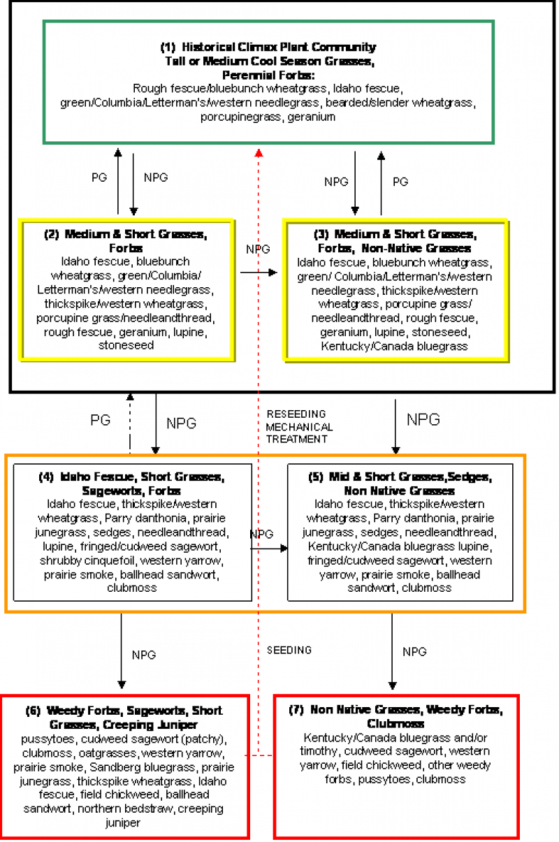
#1 -- HCPC -- Tall and Medium Grasses with Forbs.
This is the interpretive plant community and is considered to be the Historic Climax Plant Community (HCPC) for this site. This plant community contains a high diversity of tall and medium height, cool season grasses (rough fescue, bluebunch wheatgrass, Idaho fescue, green/Columbia/Letterman’s/western needlegrass, bearded/slender wheatgrass, porcupinegrass, mountain brome) and short grasses (Cusick and Sandberg bluegrass, spike oatgrass, and prairie junegrass). There are abundant forbs (geranium, prairie clovers) which occur in smaller percentages.
This plant community is well adapted to the Northern Rocky Mountain Foothills climatic conditions. The diversity in plant species allows for drought tolerance. Individual species can vary greatly in production depending on growing conditions (i.e., timing and amount of precipitation, and temperature). It is well suited to managed livestock grazing and provides diverse habitat for many wildlife species.
These plants have strong, healthy root systems that allow production to increase significantly with favorable growing conditions. This plant community provides for soil stability and a properly functioning hydrologic cycle. Abundant plant litter is available for soil building and moisture retention. Plant litter is properly distributed with very little movement off-site and natural plant mortality is very low. The soils associated with this site provide a very favorable soil-water-plant relationship.
#2 -- Medium and Short Grasses with Forbs
Early stages of degradation, including non-prescribed grazing, will tend to change the HCPC to a community dominated by medium and short grasses such as Idaho fescue, needleandthread (mainly 15 inches MAP or less), thickspike/western wheatgrass, Cusick and Sandberg bluegrass, spike oatgrass, and prairie junegrass,. Most of the taller, more palatable grasses (rough fescue, bluebunch wheatgrass, tall needlegrasses, porcupinegrass) will still be present but in smaller amounts. Palatable and nutritious forbs will begin to be replaced by less desirable and more aggressive species such as lupine and stoneseed.
#3 -- Medium & Short Grasses/Forbs/Non-Native Grasses
Given the right circumstances and opportunity, non-native grasses such as Kentucky/Canada bluegrass or common timothy will become established on this ecological site. In this situation, slight degradation in the historical climax plant community results in a plant community similar to #2, except that it will also have these non native plants as minor components. If further degradation continues, these species will continue to increase and replace other, more desirable native species.
Biomass production and litter become slightly reduced on the site with Communities 2 and 3, as the taller grasses become replaced by shorter ones, especially the non-native grasses. Evapotranspiration tends to increase, moisture retention is reduced, and soil surface temperatures increase. Some natural ecological processes will be altered. These plant communities provide for moderate soil stability. Increased amounts of bare ground can result in undesirable species invading. Common invaders can include leafy spurge, dalmation toadflax, and sulphur cinquefoil.
The following plant communities are the result of long-term, heavy, continuous season long grazing and/or heavy, annual, early spring grazing. Repeated spring grazing depletes stored carbohydrates, resulting in weakening and eventual death of the cool season tall and medium grasses. These plant communities can occur throughout the pasture, on spot grazed areas, and near water sources where season-long grazing patterns occur.
It is critical at this point to consider implementing a change in grazing management to prevent further degradation to any of the following plant communities and minimize the increase of less desirable and non native species. Once any of the following communities become established, the potential to return to communities 1, 2, or 3 is reduced and often requires a significant amount of time along with economic inputs.
#4 -- Idaho Fescue, Short Grasses/Sageworts/Forbs
With continued heavy disturbance on community 2, the site will become dominated by species such as Idaho fescue, thickspike or western wheatgrass, Parry danthonia, prairie junegrass, sedges, needleandthread (15 inches MAP or less), fringed and/or cudweed sagewort, and perennial forbs such as lupine, western yarrow, prairie smoke and ballhead sandwort. There may still be remnant amounts of some of the late-seral species such as bluebunch wheatgrass and green/Columbia needlegrass present. The taller grasses will occur only occasionally, often within horizontal juniper plants. Palatable forbs will be mostly absent. Shrubby cinquefoil can become a significant component, particularly in the higher moisture areas (> 17 inches precipitation) of this MLRA/RRU.
#5 -- Mid & Short Grasses/Sedges/Non-Native Grasses
As heavy disturbance continues, plant community 3 deteriorates to one similar to community number 4, except that non-native bluegrasses (Kentucky/Canada) and/or common timothy become more abundant, often comprising up to about 25 percent of the composition.
Plant communities 4 & 5 are often less productive than Plant Communities 1, 2, or 3. The lack of litter and short plant heights result in higher soil temperatures, poor water infiltration rates, and higher evapotranspiration rates, thus eventually favoring species that are more adapted to drier conditions. These communities have lost many of the attributes of a healthy rangeland, including good infiltration, minimal erosion and runoff, nutrient cycling and energy flow.
Communities 4 and 5 will respond positively to improved grazing management, but significant economic inputs and time will usually also be needed to move them toward a higher successional stage. Once plants such as Kentucky or Canada bluegrass or timothy become established, they are very difficult to remove and replace by grazing management alone. Additionally, the chances for success are significantly reduced.
#6 -- Weedy Forbs/Sageworts/Short Grasses/Creeping Juniper
If community 4 deteriorates further due to non-prescribed grazing or other disturbance, it becomes dominated by weedy forbs (pussytoes, cudweed sagewort, western yarrow, prairie smoke, field chickweed, northern bedstraw and ballhead sandwort), short grasses (Sandberg bluegrass, and prairie junegrass), and half shrubs such as fringed sagewort. There is often a remnant amount of some of the mid-seral grasses such as thickspike wheatgrass and Idaho fescue, usually widely spaced. Creeping juniper can become abundant in the northern part of this MLRU. Frequently, a remnant population of climax species such as rough fescue and bluebunch wheatgrass will occur within the creeping juniper.
#7 -- Non-Native Grasses/Weedy Forbs/Clubmoss
Further deterioration of community 5 due to non-prescribed grazing or other disturbance leads to a plant community dominated by Kentucky/Canada bluegrass and/or common timothy, often comprising 25 to 80 % of the community. Weedy forbs including field chickweed, cudweed sagewort, and pussytoes are abundant and typically comprise the rest of the plant composition. A thick cover of dense clubmoss often completes this community. Occasionally, in places receiving 17 inches or greater precipitation, some short lived native species such as mountain brome can become dominant after major disturbance from grazing or rodent (pocket gopher mainly) activity.
Plant communities 6 and 7 have extremely reduced production of desirable native plants. The lack of litter and short plant heights result in higher soil surface temperatures, poor water infiltration rates, and increased evaporation, which gives short grasses, weedy forbs, and invader species a competitive advantage over the cool season tall and medium grasses. These communities have lost most of the attributes of a healthy rangeland, including good infiltration, minimal runoff and erosion, nutrient cycling and energy flow.
Significant economic inputs such as seeding and/or mechanical treatment practices are needed, along with extended rest and prescribed grazing management, to restore these plant communities to a higher successional stage.
STATE AND TRANSITION MODEL DIAGRAM NOTES:
1. Kentucky and Canada bluegrass and common timothy can become a part of any plant community in this ecological site, depending on factors such as site history, circumstances, and the opportunity for these plants to establish. Generally, the percent composition of these will increase as the ecological condition degrades until they will become dominant.
2. Smaller boxes within a larger box indicate that these communities will normally shift among themselves with slight variations in precipitation and other disturbances. Moving outside the larger box indicates the community has crossed a threshold (heavier line) and will require intensive treatment to return to Community 1, 2 or 3.
3. Dotted lines indicate a reduced probability for success.
4. Yellow boxes (around Communities 2 & 3 individually) indicate caution that the community may be in danger of crossing a threshold.
5. Orange boxes (grouping Communities 4 & 5)represent communities that have crossed over thresholds from the HCPC and may be difficult to restore with grazing management alone.
6. Red boxes (around Communities 6 & 7 individually) represent communities that have severely shifted away from the HCPC and probably cannot be restored without mechanical inputs.
7. Not all species present in the community are listed in this table. Species listed are representative of the plant functional groups that occur in the community.
LEGEND:
PG = Prescribed Grazing: Use of a planned grazing strategy to balance animal forage demand with available forage resources. Timing, duration, and frequency of grazing are controlled and some type of grazing rotation is applied to allow for plant recovery following grazing.
NPG = Non-Prescribed Grazing: Grazing which has taken place that does not control the factors as listed above, or animal forage demand is higher than the available forage supply.
Community 1.1 HCPC -- Tall and Medium Grasses with Forbs.
This is the interpretive plant community and is considered to be the Historic Climax Plant Community (HCPC) for this site. This plant community contains a high diversity of tall and medium height, cool season grasses (rough fescue, bluebunch wheatgrass, Idaho fescue, green/Columbia/Letterman’s/western needlegrass, bearded/slender wheatgrass, porcupinegrass, mountain brome) and short grasses (Cusick and Sandberg bluegrass, spike oatgrass, and prairie junegrass). There are abundant forbs (geranium, prairie clovers) which occur in smaller percentages.
This plant community is well adapted to the Northern Rocky Mountain Foothills climatic conditions. The diversity in plant species allows for drought tolerance. Individual species can vary greatly in production depending on growing conditions (i.e., timing and amount of precipitation, and temperature). It is well suited to managed livestock grazing and provides diverse habitat for many wildlife species.
These plants have strong, healthy root systems that allow production to increase significantly with favorable growing conditions. This plant community provides for soil stability and a properly functioning hydrologic cycle. Abundant plant litter is available for soil building and moisture retention. Plant litter is properly distributed with very little movement off-site and natural plant mortality is very low. The soils associated with this site provide a very favorable soil-water-plant relationship.
Figure 8. Annual production by plant type (representative values) or group (midpoint values)
Table 5. Annual production by plant type
Plant type
Low (lb/acre)
Representative value (lb/acre)
High (lb/acre)
Grass/Grasslike
1310
1650
1985
Forb
330
465
600
Shrub/Vine
0
1
1
Total
1640
2116
2586
Table 6. Ground cover
Tree foliar cover
0%
Shrub/vine/liana foliar cover
0-5%
Grass/grasslike foliar cover
75-90%
Forb foliar cover
1-10%
Non-vascular plants
0%
Biological crusts
0-5%
Litter
0%
Surface fragments >0.25" and <=3"
0%
Surface fragments >3"
0%
Bedrock
0%
Water
0%
Bare ground
0%
Table 7. Soil surface cover
Tree basal cover
0%
Shrub/vine/liana basal cover
0-2%
Grass/grasslike basal cover
20-25%
Forb basal cover
1-5%
Non-vascular plants
0%
Biological crusts
0-2%
Litter
60-70%
Surface fragments >0.25" and <=3"
0-1%
Surface fragments >3"
0%
Bedrock
0%
Water
0%
Bare ground
0-1%
Table 8. Canopy structure (% cover)
Height Above Ground (ft)
Tree
Shrub/Vine
Grass/ Grasslike
Forb
<0.5
–
–
–
–
>0.5 <= 1
–
–
–
1-10%
>1 <= 2
–
0-5%
75-90%
–
>2 <= 4.5
–
–
–
–
>4.5 <= 13
–
–
–
–
>13 <= 40
–
–
–
–
>40 <= 80
–
–
–
–
>80 <= 120
–
–
–
–
>120
–
–
–
–
Community 1.2 Medium and Short Grasses with Forbs
Early stages of degradation, including non-prescribed grazing, will tend to change the HCPC to a community dominated by medium and short grasses such as Idaho fescue, needleandthread (mainly 15 inches MAP or less), thickspike/western wheatgrass, Cusick and Sandberg bluegrass, spike oatgrass, and prairie junegrass. Most of the taller, more palatable grasses (rough fescue, bluebunch wheatgrass, tall needlegrasses, porcupinegrass) will still be present but in smaller amounts. Palatable and nutritious forbs will begin to be replaced by less desirable and more aggressive species such as lupine and stoneseed.
Community 1.3 Medium & Short Grasses/Forbs/Non-Native Grasses
Given the right circumstances and opportunity, non-native grasses such as Kentucky/Canada bluegrass or common timothy will become established on this ecological site. In this situation, slight degradation in the historical climax plant community results in a plant community similar to #2, except that it will also have these non native plants as minor components. If further degradation continues, these species will continue to increase and replace other, more desirable native species.
Biomass production and litter become slightly reduced on the site with Communities 2 and 3, as the taller grasses become replaced by shorter ones, especially the non-native grasses. Evapotranspiration tends to increase, moisture retention is reduced, and soil surface temperatures increase. Some natural ecological processes will be altered. These plant communities provide for moderate soil stability. Increased amounts of bare ground can result in undesirable species invading. Common invaders can include leafy spurge, dalmation toadflax, and sulphur cinquefoil.
The following plant communities are the result of long-term, heavy, continuous season long grazing and/or heavy, annual, early spring grazing. Repeated spring grazing depletes stored carbohydrates, resulting in weakening and eventual death of the cool season tall and medium grasses. These plant communities can occur throughout the pasture, on spot grazed areas, and near water sources where season-long grazing patterns occur.
It is critical at this point to consider implementing a change in grazing management to prevent further degradation to any of the following plant communities and minimize the increase of less desirable and non native species. Once any of the following communities become established, the potential to return to communities 1, 2, or 3 is reduced and often requires a significant amount of time along with economic inputs.
State 2 Altered
Community 2.1 Idaho Fescue, Short Grasses/Sageworts/Forbs
With continued heavy disturbance on community 2, the site will become dominated by species such as Idaho fescue, thickspike or western wheatgrass, Parry danthonia, prairie junegrass, sedges, needleandthread (15 inches MAP or less), fringed and/or cudweed sagewort, and perennial forbs such as lupine, western yarrow, prairie smoke and ballhead sandwort. There may still be remnant amounts of some of the late-seral species such as bluebunch wheatgrass and green/Columbia needlegrass present. The taller grasses will occur only occasionally, often within horizontal juniper plants. Palatable forbs will be mostly absent. Shrubby cinquefoil can become a significant component, particularly in the higher moisture areas (> 17 inches precipitation) of this MLRA/RRU.
Community 2.2 Mid & Short Grasses/Sedges/Non-Native Grasses
As heavy disturbance continues, plant community 3 deteriorates to one similar to community number 4, except that non-native bluegrasses (Kentucky/Canada) and/or common timothy become more abundant, often comprising up to about 25 percent of the composition.
Plant communities 4 & 5 are often less productive than Plant Communities 1, 2, or 3. The lack of litter and short plant heights result in higher soil temperatures, poor water infiltration rates, and higher evapotranspiration rates, thus eventually favoring species that are more adapted to drier conditions. These communities have lost many of the attributes of a healthy rangeland, including good infiltration, minimal erosion and runoff, nutrient cycling and energy flow.
Communities 4 and 5 will respond positively to improved grazing management, but significant economic inputs and time will usually also be needed to move them toward a higher successional stage. Once plants such as Kentucky or Canada bluegrass or timothy become established, they are very difficult to remove and replace by grazing management alone. Additionally, the chances for success are significantly reduced.
State 3 Degraded
Community 3.1 Weedy Forbs/Sageworts/Short Grasses/Creeping Juniper
If community 4 deteriorates further due to non-prescribed grazing or other disturbance, it becomes dominated by weedy forbs (pussytoes, cudweed sagewort, western yarrow, prairie smoke, field chickweed, northern bedstraw and ballhead sandwort), short grasses (Sandberg bluegrass, and prairie junegrass), and half shrubs such as fringed sagewort. There is often a remnant amount of some of the mid-seral grasses such as thickspike wheatgrass and Idaho fescue, usually widely spaced. Creeping juniper can become abundant in the northern part of this MLRU. Frequently, a remnant population of climax species such as rough fescue and bluebunch wheatgrass will occur within the creeping juniper.
State 4 Invaded
Community 4.1 Non-Native Grasses/Weedy Forbs/Clubmoss
Further deterioration of community 5 due to non-prescribed grazing or other disturbance leads to a plant community dominated by Kentucky/Canada bluegrass and/or common timothy, often comprising 25 to 80 % of the community. Weedy forbs including field chickweed, cudweed sagewort, and pussytoes are abundant and typically comprise the rest of the plant composition. A thick cover of dense clubmoss often completes this community. Occasionally, in places receiving 17 inches or greater precipitation, some short lived native species such as mountain brome can become dominant after major disturbance from grazing or rodent (pocket gopher mainly) activity.
Plant communities 6 and 7 have extremely reduced production of desirable native plants. The lack of litter and short plant heights result in higher soil surface temperatures, poor water infiltration rates, and increased evaporation, which gives short grasses, weedy forbs, and invader species a competitive advantage over the cool season tall and medium grasses. These communities have lost most of the attributes of a healthy rangeland, including good infiltration, minimal runoff and erosion, nutrient cycling and energy flow.
Significant economic inputs such as seeding and/or mechanical treatment practices are needed, along with extended rest and prescribed grazing management, to restore these plant communities to a higher successional stage.
Additional community tables
Table 9. Community 1.1 plant community composition
Managed livestock grazing is suitable on this site as it has the potential to produce an abundance of high quality forage. This is often a preferred site for grazing by livestock, and animals tend to congregate in these areas. In order to maintain the productivity of the Silty site, grazing on adjoining sites with less production must be managed carefully to be sure utilization on this site is not excessive. Management objectives should include maintenance or improvement of the plant community.
Using shorter grazing periods and providing for adequate re-growth after grazing are recommended for plant maintenance, health, and recovery. Continual over stocking and season-long use of this site can be detrimental and will alter the plant composition and production over time, resulting in plant communities that resemble numbers 4 through 7. Repeated heavy early spring grazing, especially during stem elongation (generally mid May through mid June), can also have detrimental affects on the taller, key forage species.
Whenever Plant Communities 2 or 3 (Medium and short grasses) occur, grazing management strategies need to be implemented to avoid further deterioration. These communities are still stable, productive, and healthy provided they receive proper management. These will respond fairly quickly to improved grazing management, including increased growing season rest of key forage plants. Grazing management alone can usually move these back towards the potential / historic climax community, particularly if the non native grasses such as Kentucky/Canada bluegrass and/or common timothy, are not significant components.
Plant Communities 4 and 5 have a high percentage of aggressive, less-desirable species. Once these have become established, it is significantly more difficult using grazing management alone to restore the site to one that resembles the HCPC/PPC. Reseeding and/or mechanical treatment are sometimes needed along with additional growing season rest for re-establishment of the desired species and to restore the stability and health of the site, especially with Community 5 having a relatively high percentage of non native perennial grasses.
Plant community 6 has a high percentage of non desirable forage species and an extremely limited production of usable forage (< 600 pounds per acre). Community 7 has a high amount of non native perennial grasses that can be good forage, but generally for only a short time during the early part of the grazing season. The bluegrasses and timothy are highly competetive once established, making seeding usually necessary to restore desirable native perennial species.
Stocking rates are calculated from average forage production values using a 25% Harvest Efficiency factor for preferred and desirable plants, and 10% Harvest Efficiency for less desirable species. AUM calculations are based on 790 pounds per animal unit month (AUM) for a 1,000-pound cow with calf up to 4 months. No adjustments have been made for site grazability factors, such as steep slopes, site inaccessibility, or distance to drinking water.
The following is an example of how to calculate the recommended stocking rate. This example does not use production estimates from this specific ecological site. You will need to adjust the annual production values and run the calculations using total annual production values from the ecological sites encountered on each individual ranch/pasture. Before making specific recommendations, an on-site evaluation must be made.
Example of total annual production amounts by type of year:
Favorable years = 2200 lbs/acre
Normal years = 1480 lbs/acre
Unfavorable years = 1200 lbs/acre
It is recommended that on slopes of 30% or less, stocking rate should be derived from the total annual production pounds minus 500 pounds for residual dry matter and 25% harvest efficiency. On slopes over 30%, stocking rate is derived from total annual production pounds minus 800 pounds for residual dry matter and 25% harvest efficiency. Refer to the NRCS National Range and Pasture Handbook for a list of Animal Unit Equivalents.
Sample Calculations using Favorable Year production amounts:
< 30% slopes: AUM/AC = [(2200-500)(0.25)]/915 lbs/month for one AU = 0.46 AUM/AC
AC/AUM = (1.0 AU)/(0.46AUM/AC) = 2.2 AC/AUM
> 30% slopes: AUM/AC = [(2200-800)(0.25)]/915 lbs/month for one AU = 0.38 AUM/AC
AC/AUM = (1.0 AU)/(0.38 AU! M/AC) = 2.6 AC/AUM
NOTE: 915 lbs/month for one Animal Unit is used as the baseline for maintenance requirements. This equates to 30 lbs/day of air-dry forage (1200 lb cow at 2.5% of body weight).
WILDLIFE INTERPRETATIONS:
The Silty 13-19” p.z. ecological site occurs over large acreages on the Northern Great Plains except where it is fragmented by conversion to cropland, which is significant in many areas. Habitat fragmentation of this site has contributed to the decline of some “area sensitive” wildlife species, particularly such ground-nesting birds as the grasshopper sparrow. This site is home to a diverse native wildlife complex. Historically, huge herds of migratory bison, elk and pronghorn as well as large numbers of sharp-tailed grouse were probably the dominant “game” species in addition to a wide variety of ground-nesting songbirds, waterfowl and shorebirds, small mammals, and mammalian predators. Grazing patterns, topographic diversity, extensive acreages, and interspersion with other ecological sites make this type very important to numerous wildlife species. Small mammal diversity and abundance is high which supports a varied raptor population. Ferruginous hawks and golden eagles, for example, make considerable use of this ecological site along the East Front of the Rockies where Richardson’s grounds squirrels and white-tailed jack rabbits are abundant. Invasive plant species such as leafy spurge, Dalmatian toadflax, and several knapweeds may contribute to a loss of biodiversity within this ecological site. Wildlife water requirements are provided by springs and seeps, intermittent and perennial streams, and, in modern times, numerous artificial ponds and livestock pipelines. These areas are locally important for northern leopard frogs, tiger salamanders and chorus frogs, all of which feed on a variety of insects. Grazing, fire, drought cycles and insect population fluctuations create a shifting mosaic of wildlife habitats across this site.
Plant Community 1: Tall or Medium Cool Season Grasses, Perennial Forbs (HCPC): The diversity of plant species and life forms provides feeding substrate for many species of pollinating insects. A variety of fish species inhabit the intermittent and perennial streams associated with this community. The Northern pike, longnose sucker, longnose dace, rainbow and brook trout, mountain whitefish and mottled sculpin are examples. Common reptile and amphibian species include the tiger salamander in ponds and stock tanks, western chorus frog, short-horned lizard, racer and rattlesnake, and two species of garter snakes. The diversity of grass stature and life forms, along with scattered shrubs and a variety of forbs, provides habitat for many bird species including the marbled godwit, sharp-tailed grouse, loggerhead shrike, grasshopper and vesper sparrow, chestnut-collared longspur and western meadowlark. This community is especially favorable for ground-nesting birds because of the abundant residual plant material and litter available for nesting, escape, and thermal cover. Diverse prey populations are available for raptors such as ferruginous and Swainson’s hawks. The predominance of grasses plus a diversity of forbs, shrubs and half-shrubs in this community favors grazers and mixed feeders such as bison, pronghorn and elk. Suitable thermal and escape cover for mule deer is limited because of low shrub cover and topographic diversity. Complex plant structural diversity and litter cover provide habitat for a wide array of small mammals (both seed eaters, i.e. deer mice and herbivores, i.e. voles and jackrabbits) and neotropical migratory birds.
Plant Community 2: Medium and Short Grasses, Forbs: The partial loss of structural diversity makes this plant community somewhat less attractive to the variety of wildlife species using the HCPC. A decrease in residual plant material and litter cover is usually associated with degradation of the HCPC, which makes this community less attractive for ground-nesting birds. Pronghorn make considerable use of this type because of forb availability in the generally open landscape.
Plant Community 3: Medium and Short Grasses, Forbs, Non Native Grasses: Wildlife habitat values associated with this successional type are very similar to Plant Community 2, above, although the invasion of non-native grasses may reduce habitat structural diversity even more.
Plant Community 4: Idaho Fescue, Short Grasses, Sageworts, Forbs: The shorter stature and more open aspect of this community may favor ground-nesting bird species, such as the horned lark and long-billed curlew, that prefer a short grass type. Many other bird species, such as the grasshopper sparrow and sharp-tailed grouse, will find less suitable nesting habitat with the reduction of residual plant material, litter and taller grass species. The abundant forbs and half-shrubs provide quality forage for pronghorn and mule deer. Small mammal populations my shift toward more abundant seed-eaters, like the deer mouse, and away from herbivores such as the meadow vole. Pollinator insect populations may suffer from the change in native forb diversity.
Plant Community 5: Mid and Short Grasses, Sedges, Non Native Grasses: Wildlife habitat values in this type are very similar to Plant Community 4, above. However, the invasion of non-native grasses may degrade habitat diversity to an even greater extent.
Plant Community 6: Weedy Forbs, Sageworts, Short Grasses, Creeping Juniper: Creeping juniper is a primary mule deer browse species along the Rocky Mountain Front. However, it is most available as winter browse when located on south and west-facing slopes which are usually associated with other ecological sites such as silty-steep and shallow. Overall habitat structure is greatly simplified in this community compared to higher successional types. A few ground-nesting bird species, such as the mountain plover and horned lark, may benefit from the shorter habitat structure and increase in bare ground.
Plant Community 7: Non-Native Grasses, Weedy Forbs, Clubmoss: For general wildlife habitat diversity, this community suffers from a greatly simplified vegetative structure and loss of variety. Pollinator insect populations lack the long flowering period associated with higher successional types. The simplified prey base (primarily small mammals) degrades habitat value for raptors and mammalian predators. Overall wildlife habitat value is quite low.
Hydrological functions
Hydrology Data: The soils associated with this ecological site are generally in Hydrologic Soil Group B. The infiltration rates for these soils will normally be moderate. The runoff potential for this site is moderate, depending on slope and ground cover/health. Runoff curve numbers generally range from 64 to 82.
Good hydrologic conditions exist on rangelands if plant cover (grass, litter, and brush canopy) is greater than 70%. Fair conditions exist when cover is between 30% and 70%, and poor conditions exist when cover is less than 30%. Sites in high similarity to HCPC (Plant Communities 1 and 2) generally have enough plant cover and litter to optimize infiltration, minimize runoff and erosion, and have a good hydrologic condition. The deep root systems of the potential vegetation help maintain or increase infiltration rates and reduce runoff.
Sites in low similarity (Plant Communities 3, 4 and 5) are generally considered to be in poor hydrologic condition as a majority of the plant cover is from shallow-rooted species.
Erosion is minor for sites in high similarity. Rills and gullies should not be present. Water flow patterns, if present, will be barely observable. Plant pedestals are essentially non-existent. Plant litter remains in place and is not moved by erosion. Plant cover and litter helps retain soil moisture for use by the plants. Soil surfaces should not be compacted or crusted. Maintaining a healthy stand of perennial vegetation will optimize the amount of precipitation that is received. (Reference: Engineering Field Manual, Chapter 2 and Montana Supplement 4).
Supporting information
Other references
Barrett, H. 2007. Western Juniper Management: A Field Guide.
Bestelmeyer, B., J.R. Brown, J.E. Herrick, D.A. Trujillo, and K.M. Havstad. 2004. Land Management in the American Southwest: a state-and-transition approach to ecosystem complexity. Environmental Management 34:38–51.
Bestelmeyer, B. and J. Brown. 2005. State-and-Transition Models 101: A Fresh look at vegetation change.
Blaisdell, J.P. 1958. Seasonal development and yield of native plants on the Upper Snake River Plains and their relation to certain climate factors.
Colberg, T.J. and J.T. Romo. 2003. Clubmoss effects on plant water status and standing crop. Journal of Range Management 56:489–495.
DiTomaso, J.M. 2000. Invasive weeds in Rangelands: Species, Impacts, and Management. Weed Science 48:255–265.
Dormaar, J.F., B.W. Adams, and W.D. Willms. 1997. Impacts of rotational grazing on mixed prairie soils and vegetation. Journal of Range Management 50:647–651.
Hobbs, J.R. and S.E. Humphries. 1995. An integrated approach to the ecology and management of plant invasions. Conservation Biology 9:761–770.
Humphrey, L. David. 1984. Patterns and mechanisms of plant succession after fire on Artemisia-grass sites in southeastern Idaho Vegetation. 57: 91-101.
Masters, R. and R. Sheley. 2001. Principles and practices for managing rangeland invasive plants. Journal of Range Management 38:21–26.
McLean, A. and S. Wikeem. 1985. Influence of season and intensity of defoliation on bluebunch wheatgrass survival and vigor in southern British Columbia. Journal of Range Management 38:21–26.
Miller, R.F., T.J. Svejcar, and J.A. Rose. 2000. Impacts of western juniper on plant community composition and structure. Journal of Range Management 53:574–585.
Ross, R.L., E.P. Murray, and J.G. Haigh. July 1973. Soil and Vegetation of Near-pristine sites in Montana.
Smoliak, S., R.L. Ditterlin, J.D. Scheetz, L.K. Holzworth, J.R. Sims, L.E. Wiesner, D.E. Baldridge, and G.L. Tibke. 2006. Montana Interagency Plant Materials Handbook.
Stavi, I. 2012. The potential use of biochar in reclaiming degraded rangelands. Journal of Environmental Planning and Management 55:1–9.
Stringham, T.K., W.C. Kreuger, and P.L. Shaver. 2003. State and Transition Modeling: an ecological process approach. Journal of Range Management 56:106–113.
Stringham, T.K. and W.C. Krueger. 2001. States, Transitions, and Thresholds: Further refinement for rangeland applications.
Tirmenstein, D. 1999. Gutierrezia sarothrae. In: Fire Effects Information System, [Online]. U.S. Department of Agriculture, Forest Service, Rocky Mountain Research Station, Fire Sciences Laboratory (Producer). https://www.fs.fed.us/database/feis/plants/shrub/gutsar/all.html [2022, March 30].
Walker, L.R. and S.D. Smith. 1997. Impacts of invasive plants on community and ecosystem properties. Pages 69–86 in Assessment and management of plant invasions. Springer, New York, NY.
Whitford, W.G., E.F. Aldon, D.W. Freckman, Y. Steinberger, and L.W. Parker. 1989. Effects of Organic Amendments on Soil Biota on a Degraded Rangeland. Journal of Range Management 41:56–60.
Wilson, A.M., G.A. Harris, and D.H. Gates. 1966. Cumulative Effects of Clipping on Yield of Bluebunch wheatgrass. Journal of Range Management 19:90–91.
Contributors
All Site Authors Robert Leinard; Jon Siddoway; Barbara Gibbons; Matthew Ricketts; Peter Husby
Approval
Kirt Walstad, 4/01/2025
Rangeland health reference sheet
Interpreting Indicators of Rangeland Health is a qualitative assessment protocol used to
determine ecosystem condition based on benchmark characteristics described in the Reference Sheet. A suite of 17 (or
more) indicators are typically considered in an assessment. The ecological site(s) representative of an assessment
location must be known prior to applying the protocol and must be verified based on soils and climate. Current plant
community cannot be used to identify the ecological site.
Author(s)/participant(s)
J. Siddoway, R. Bandy, G. Petersen
Contact for lead author
grant.petersen@usda.gov
Date
04/19/2005
Approved by
Kirt Walstad
Approval date
Composition (Indicators 10 and 12) based on
Annual Production
Indicators
Number and extent of rills:
Slopes most common on this site are between 0 – 8% and with at least 99+% of the soil surface well-covered there are no rills even with the most extreme convection storms. Rills would be rare on slopes of 9 – 15%.
Presence of water flow patterns:
Due to the soil surface being well covered and minimal slope there is no evidence of past or current soil deposition or erosion for this site.
Number and height of erosional pedestals or terracettes:
Wind and water erosion will not be evident on this site, so pedestals and terracettes will not be present.
Bare ground from Ecological Site Description or other studies (rock, litter, lichen, moss, plant canopy are
not bare ground):
Bare ground should be no more than a trace amount on this site.
Number of gullies and erosion associated with gullies:
Gully erosion will not be evident on this site.
Extent of wind scoured, blowouts and/or depositional areas:
Appearance or evidence of these erosional features on the landscape would not be present on this site.
Amount of litter movement (describe size and distance expected to travel):
Because there is little bare ground, litter movement will be minimal at most. Because the site is dominated by the taller bunchgrasses, litter size will reflect the height and diameter of the reproductive culms and leaves of these grasses as well as the lesser dominate mid-size grasses.
Soil surface (top few mm) resistance to erosion (stability values are averages - most sites will show a range
of values):
Resistance to erosion will be high with soil stability values of 5 or 6; areas of bare soil on this site may have values less than 5 if not under plant canopy.
Soil surface structure and SOM content (include type of structure and A-horizon color and thickness):
Soil surface structure is granular; A horizon depth is 5 – 11”.
Effect of community phase composition (relative proportion of different functional groups) and spatial
distribution on infiltration and runoff:
Dominance of taller, deep rooted bunchgrasses will maximize infiltration and minimize runoff throughout the site.
Presence and thickness of compaction layer (usually none; describe soil profile features which may be
mistaken for compaction on this site):
Will not be present generally, but there may be areas that have “healed” from former bison trails and wallows as well as more current livestock trails which could have a compaction layer below the soil surface.
Functional/Structural Groups (list in order of descending dominance by above-ground annual-production or live foliar
cover using symbols: >>, >, = to indicate much greater than, greater than, and equal to):
perennial forbs > cool season midgrasses (Idaho fescue) > cool season rhizomatous grasses (thickspike wheatgrass) = warm season, short bunchgrass (plains muhly) = sedges > shrubs
Other:
Additional:
Amount of plant mortality and decadence (include which functional groups are expected to show mortality or
decadence):
Will be low for all functional groups in a given year. Prolonged droughts which last more than 3 years may show increases in mortality and decadence for all plant groups.
Average percent litter cover (%) and depth ( in):
Litter is 60 to 65 percent of varying depths up to 0.5 inches
Expected annual annual-production (this is TOTAL above-ground annual-production, not just forage annual-production):
1600 - 2500 #/acre. This would be the expected production for the reference state during adequate moisture years. 2200 pounds would be the expected production in a 17 inch precipitation zone.
Potential invasive (including noxious) species (native and non-native). List species which BOTH characterize
degraded states and have the potential to become a dominant or co-dominant species on the ecological site if
their future establishment and growth is not actively controlled by management interventions. Species that become
dominant for only one to several years (e.g., short-term response to drought or wildfire) are not invasive
plants. Note that unlike other indicators, we are describing what is NOT expected in the reference state for the
ecological site:
Kentucky bluegrass, Canada bluegrass, shrubby cinquefoil, dense clubmoss, Japanese brome, a variety of annual or biennial weedy forbs, fringed and cudweed sagewort, broom snakeweed, pussytoes, creeping juniper, field chickweed, cheatgrass.
Perennial plant reproductive capability:
During adequate moisture years bunchgrasses will generally produce seeds, however the cool season rhizomatous grasses may not necessarily produce seed even with adequate moisture.
The Ecosystem Dynamics Interpretive Tool is an information system framework developed by the USDA-ARS Jornada Experimental Range, USDA Natural Resources Conservation Service, and New Mexico State University.
Click on box and path labels to scroll to the respective text.