Natural Resources
Conservation Service
Ecological site R046XN630MT
Dense Clay (DC) RRU 46-N 10-14 PZ
Last updated: 7/19/2023
Accessed: 02/12/2026
General information
Provisional. A provisional ecological site description has undergone quality control and quality assurance review. It contains a working state and transition model and enough information to identify the ecological site.
MLRA notes
Major Land Resource Area (MLRA): 046X–Northern and Central Rocky Mountain Foothills
Major Land Resource Area (MLRA) 46, Rocky Mountain Foothills, is approximately 11.6 million acres. MLRA 46’s extent has changed over recent years and is now primarily located in Montana and Wyoming with limited acres in Utah and Colorado. It spans from the Canadian border south to the Uinta Mountains of Northwest Colorado. MLRA 46 is a transitional MLRA between the plains and mountains of primarily non-forested rangeland. In Montana, three Land Resource Units (LRUs) exist based on differences in geology, landscape, soils, water resources, and plant communities. Elevations for this MLRA in Montana vary from a low of 3200 to 6500 feet (975 to 1981 m) however the elevations on the fringes of this MLRA may fall outside of that range in extremely small isolated areas where the boundaries between neighboring MLRAs are not easily defined. Annual precipitation ranges from 8 inches (254 mm) to, in very isolated areas, 42 inches (1083 mm). In general precipitation rarely exceeds 24 inches (610 mm). Frost-free days are variable from 50 days near the Crazy and Beartooth Mountains to 130 days in the foothills south of the Bear’s Paw Mountains of Central Montana. The geology of MLRA 46 is generally Cretaceous and Jurassic marine sediments.
MLRA 46 plant communities are dominated by cool-season bunchgrasses with mixed shrubs. This MLRA is rarely forested; however, ponderosa and limber pine do occupy areas. Portions of this MRLA may have a sub dominance of warm-season mid-statured bunchgrasses like little bluestem; however, the general concept of the MLRA does not have a large component of warm-season species. Wyoming big sagebrush, mountain big sagebrush, silver sagebrush, common snowberry, and shrubby cinquefoil tend to be the dominant shrub component. The kind and presences of shrubs tends to be driven by a combination of soils and climate. Due to the variable nature of the Land Resources Units, Climatic subsets will be necessary to describe the ecological sites and the variation of plant communities for this MLRA.
LRU notes
The Rocky Mountain Front Foothills LRU is the northernmost LRU of MLRA 46. The boundaries are the Canadian border to the north, MRLA 43B and the western extent of Continental Glaciation (MLRA 52). Boundaries between these MLRAs are extremely broad and often hard to distinguish.
Major watersheds of this LRU include the Missouri River, Sun River, Teton River, Marias River, and the Milk River. All of these river systems have been modified for the purpose of irrigation of pasture and crops.
The Rocky Mountain Front Foothills LRU’s geology is generally sedimentary in nature. Primary geological units include Two Medicine Limestone & Sandstone, Colorado Shale, Glacial Drift (alluvium), Terrace deposits (alluvium) and St Mary River formation (mudstone). Landforms include outwash terraces, escarpments, fan remnants, valleys, hillslopes, and drainage ways. Elevations of this landscape is from 3221 feet (982m) to 6954 feet (2120m).
Well drained soils are dominate in this LRU. Most areas vary from nearly level to 15 percent slope, while some areas do express steeper slopes near the 43B boundary. Soils are Slight to Moderate Alkaline. Soil mean clay percentages are mostly above 23 percent and are primarily very deep at approximately 70 percent of the LRU and moderately-deep to deep soils at approximately 30 percent of the LRU.
The climate of this LRU is highly variable however the average of 16.9 inches (429mm) follows the typical MLRA concept. The major difference between this LRU and the others of MLRA 46 is the Chinook wind. These winds create massive temperature swings in the winter which can melt snow cover and initiate bud growth on shrubs. These changes may dry soil affecting plant production and species composition. The Rocky Mountain Front Foothills receives 10 inches (247 mm) to 42 inches (1083 mm) annually. However 42 inches is extremely limited extent. The average air temperature ranges from 36 degrees Fahrenheit (2.39 degrees C) to 46 degrees Fahrenheit (8.02 degrees C). The soil temperature regime is frigid with a soil moisture regime dominated by Ustic with areas of Udic. Average frost-free days is from 70 to 117 days.
The vegetation potential for the Rocky Mountain Front Foothills LRU can be variable but is dominated by rangeland. Forested extents are typically minimal and consist primarily of Douglas-fir, limber pine, ponderosa pine, and Rocky Mountain juniper with mixed grassland understory. The rangeland of this LRU follows the general concept of the MLRA. The dryer sites are dominated by bluebunch wheatgrass and as the precipitation increases and temperatures decrease rough fescue increases. In areas that receive the highest precipitation, Columbia and Richardson’s needlegrass may exist. Shrub cover is limited in this area and is generally silver sagebrush and shrubby cinquefoil with areas of chokecherry and buffaloberry (both Russet and silver). The glacial drift areas will often have wetland associated vegetation in potholes as well as large areas of quaking aspen with mixed meadows.
Conversion from rangeland to cropland has been the largest land use change of this relatively intact grassland system. Small grain (barley and wheat) production is the most common crop produced in this area. Forage crops such as hay barley, perennial grass pasture, and alfalfa hay are also common. Irrigation from the area's extensive water resources facilitates highly productive farming practices.
MLRA 46 has experienced high conversion from rangeland to urban development where larger expanses of land have been separated into smaller ranchette subdivisions. Often these ranchettes experience extremely high grazing pressure from companion animals.
Classification relationships
EPA Ecoregion Level III: Canadian Rockies
Level IV: Northern Front
Southern Carbonate Front
EPA Ecoregion Level III: Northwestern Glaciated Plains
Level IV: Rocky Mountain Front Foothill Potholes
Sweetgrass Uplands
Foothills Grasslands
Glaciated Northern Grasslands
EPA Ecoregion Level III: Northwestern Great Plains
Level IV: Limy Foothill Grassland
Judith Basin Grassland
Ecological site concept
• Site does not receive additional effective moisture
• Soils are natric or have relic natric horizons
• Columnar structure present with abrupt root or water restrictive clay layer present within
4 inches of soil surface
Associated sites
| R046XN628MT |
Claypan (Cp) RRU 46-N 13-19 PZ Claypan typically has higher landscape position above the Dense Clay site |
|---|
Similar sites
| R046XN628MT |
Claypan (Cp) RRU 46-N 13-19 PZ Similar plant community and STM however produces nearly 50 percent more production. |
|---|
Table 1. Dominant plant species
| Tree |
Not specified |
|---|---|
| Shrub |
(1) Artemisia tridentata |
| Herbaceous |
(1) Pseudoroegneria spicata |
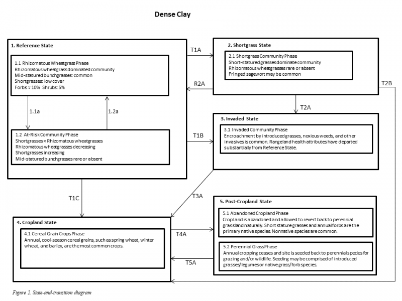
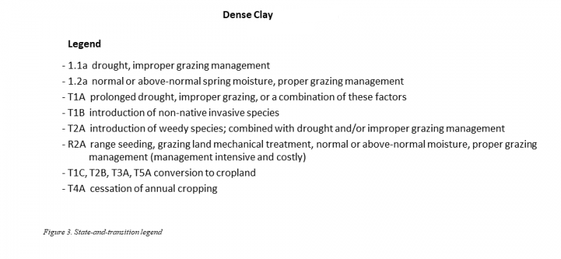
Click on box and path labels to scroll to the respective text.

