Slough (Sl)
Scenario model
Current ecosystem state
Select a state
Management practices/drivers
Select a transition or restoration pathway
-
No transition or restoration pathway between the selected states has been described
Target ecosystem state
Select a state
State 1
Reference


Description
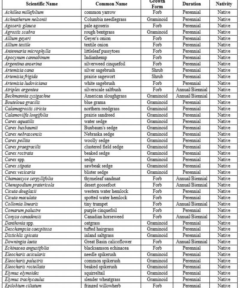
The Reference State (1) contains three community phases. Ecological dynamics of this state are still under investigation, therefore, this model may not cover the full range of conditions, species, and responses for the state. Seasonal ponding is a key dynamic on this site and varies depending on annual precipitation patterns and groundwater inputs. Vegetation is typically characterized by zones within the site that correspond to the hydroperiod of that particular zone. Phases usually exhibit two or more zones with the most hydrophytic vegetation in the center of the site and subsequent, drier plant communities toward the edges. Dominant plant species that occur on the Slough ecological site are cattail, bulrush, sedges, and spikerush (Jones, 2004; Hansen et al., 1995). Plant communities can be diverse and may contain numerous other species in addition to the dominant species. Table 5 contains a list of species that have been observed in the Reference State (1). Cyclical periods of drought and wet occur, on average, every 10 to 20 years and are a crucial ecological process on this site (Luna et. al., 2010). During these cycles the site undergoes a dry phase that promotes regeneration of key species such as hardstem bulrush and broadleaf cattail, which require open mudflats to regenerate. This cyclical pattern helps to maintain stand integrity, species diversity, and wildlife habitat.
Community Phase 1.1: Shallow Marsh Phase
The Shallow Marsh Phase (1.1) occurs during drought cycles. Ponding depth and hydroperiod are reduced and the center of the site supports a sedge-spikerush dominated plant community. The fringes of the site drawdown to bare mudflats in this stage, providing ideal conditions for germination and regeneration of cattails and bulrushes.
Community Phase Pathway 1.1a
Two or more years of average precipitation will transition the Shallow Marsh Phase (1.1) to the Deep Marsh Phase (1.2).
Community Phase 1.2: Deep Marsh Phase
The Deep Marsh Phase (1.2) occurs during periods of average or near average precipitation. In this phase the hydroperiod ranges from 6 to 9 months. Vegetation exhibits zonation in this phase. At the center of the depression, where ponding depth is greatest, a cattail-bulrush plant community appears. The most common species in this zone are broadleaf cattail, hardstem bulrush, and common threesquare. A sedge-spikerush plant community is usually present around the rim of the site and frequently supports water sedge, Nebraska sedge, and needle spikerush. A number of minor graminoid species such as American sloughgrass, prairie cordgrass, and rushes may also be present. Stands of cattail and bulrush are expanding in this phase. Species diversity is very high in this phase.
Community Phase Pathway 1.2a
Drought will transition the Deep Marsh Phase (1.2) to the Shallow Marsh Phase (1.1).
Community Phase Pathway 1.2b
Two or more years of above-average precipitation will transition the Deep Marsh Phase (1.2) to the Open Water Phase (1.3).
Community Phase 1.3: Open Water Phase
The Open Water Phase (1.3) occurs during wet climatic cycles. It is characterized by a long hydroperiod (8 to 9 months) and the development of an open water area in the center of the site. Cattail and bulrush stands are declining and limited to the fringes of the site. Aquatic species such as water knotweed, pondweed, and duckweed are common. A number of minor species such as sedges, rushes, and grasses may also be present. Species diversity in this phase will decline over time until water levels are drawn down by the natural climate cycle.
Community Phase Pathway 1.3a
Two or more years of average precipitation will transition the Open Water Phase (1.3) to the Deep Marsh Phase (1.2).
Transition T1A
Hydrologic alteration due to dams, irrigation, impoundment, or a combination of factors will transition the Reference State (1) to the Hydrologically Altered State (3).
Transition T1B
Introduction of invasive species will transition the Reference State (1) to the Invaded State (2).
Description
The Invaded State (2) occurs when invasive plant species invade adjacent native plant communities. Invasive species are not common, nor are they well documented on the Slough ecological site. However, species such as reed canarygrass, narrowleaf cattail, and European common reed have been observed on this site in some instances. Left unchecked, these species can form dense stands and reduce cover and diversity of desirable species.
Noxious weeds are also rare on the Slough ecological site, however, weeds such as purple loosestrife and Eurasian watermilfoil have been documented in MLRA 52 and would become a major concern if established on this site. These species are very aggressive perennials that typically displace native species and dominate ecological function when they invade a site. Sometimes, these species can be suppressed through intensive management (herbicide, biological control, or intensive grazing management). Control efforts are unlikely to eliminate noxious weeds, but their density can be sufficiently suppressed so that species composition and structural complexity are similar to that of the Reference State (1). However, cessation of control methods will most likely result in recolonization of the site by the noxious species.
Community Phase 2.1: Invaded Community Phase
The Invaded Community Phase (2.1) occurs when encroachment by introduced grasses, noxious weeds, and other invasive plants are common. Rangeland health attributes have departed substantially from the Reference State (1).
Description
The Hydrologically Altered State (3) occurs when hydrology is altered by damming, irrigation projects, or water impoundment. Natural drought/wet cycles are reduced or eliminated and the associated variations in hydroperiod are diminished. The result is a perpetual Open Water Phase (1.3) and a reduction in biodiversity and emergent vegetation regeneration. This state is particularly common in the Milk River valley where large storage reservoirs have regulated stream flows and flood irrigation has raised water tables across much of the floodplain.
Community Phase 3.1: Altered Community Phase
The Altered Community Phase (3.1) consists of a predominantly open water wetland with a fringe area dominated by emergent perennials such as broadleaf cattail, hardstem bulrush, and common threesquare. Stands of emergent vegetation are frequently monocultures with very little regeneration. Natural drawdown cycles necessary for regeneration are drastically reduced. A shallow marsh zone supporting sedge and spikerush species may be present, but is generally very narrow. Species richness and diversity are much less than in the Reference State (1).
Restoration Pathway R3A
Restoration of natural hydrology and species diversity transitions the Altered State (3) to the Reference State (1). Restoration of natural hydrology may require removal of dams or diversions, and alteration of irrigation practices. Depending on site conditions, revegetation may be required to restore species diversity. Specialized seeding techniques may be necessary as well as intensive weed control to prevent invasion of exotic species and noxious weeds. These restoration methods are labor intensive, very costly, and may be impractical, perhaps even detrimental, in most situations.
Transition T3A
Introduction of invasive species will transition the Hydrologically Altered State (3) to the Invaded State (2).
Model keys
Briefcase
Add ecological sites and Major Land Resource Areas to your briefcase by clicking on the briefcase (![]() ) icon wherever it occurs. Drag and drop items to reorder. Cookies are used to store briefcase items between browsing sessions. Because of this, the number of items that can be added to your briefcase is limited, and briefcase items added on one device and browser cannot be accessed from another device or browser. Users who do not wish to place cookies on their devices should not use the briefcase tool. Briefcase cookies serve no other purpose than described here and are deleted whenever browsing history is cleared.
) icon wherever it occurs. Drag and drop items to reorder. Cookies are used to store briefcase items between browsing sessions. Because of this, the number of items that can be added to your briefcase is limited, and briefcase items added on one device and browser cannot be accessed from another device or browser. Users who do not wish to place cookies on their devices should not use the briefcase tool. Briefcase cookies serve no other purpose than described here and are deleted whenever browsing history is cleared.
Ecological sites
Major Land Resource Areas
The Ecosystem Dynamics Interpretive Tool is an information system framework developed by the USDA-ARS Jornada Experimental Range, USDA Natural Resources Conservation Service, and New Mexico State University.
