Provisional. A provisional ecological site description has undergone quality control and quality assurance review. It contains a working state and transition model and enough information to identify the ecological site.
MLRA notes
Major Land Resource Area (MLRA): 052X–Brown Glaciated Plains
The Brown Glaciated Plains, MLRA 52, is an expansive and agriculturally and ecologically significant area. It consists of approximately 14.5 million acres and stretches across 350 miles from east to west, encompassing portions of 15 counties in north-central Montana. This region represents the southwestern limit of the Laurentide Ice Sheet and is considered to be the driest and westernmost area within the vast network of glacially derived prairie pothole landforms of the northern Great Plains. Elevation ranges from 2,000 feet (610 meters) to 4,600 feet (1,400 meters).
Soils are primarily Mollisols, but Entisols, Inceptisols, Alfisols, and Vertisols are also common. Till from continental glaciation is the predominant parent material, but alluvium and bedrock are also common. Till deposits are typically less than 50 feet thick, and in some areas glacially deformed bedrock occurs at or near the soil surface (Soller, 2001). Underlying the till is sedimentary bedrock largely consisting of Cretaceous shale, sandstone, and mudstone (Vuke et al., 2007). The bedrock is commonly exposed on hillslopes, particularly along drainageways. Significant alluvial deposits occur along glacial outwash channels and major drainages, including portions of the Missouri, Teton, Marias, Milk, and Frenchman Rivers. Large glacial lakes, particularly in the western half of the MLRA, deposited clayey and silty lacustrine sediments (Fullerton et al., 2013).
Much of the western portion of this MLRA was glaciated towards the end of the Wisconsin age, and the maximum glacial extent occurred approximately 20,000 years ago (Fullerton et al., 2004). The result is a geologically young landscape that is predominantly a level till plain interspersed with lake plains and dominated by soils in the Mollisol and Vertisol orders. These soils are very productive and generally are well suited to dryland farming. Much of this area is aridic-ustic. Crop-fallow dryland wheat farming is the predominant land use. Areas of rangeland typically are on steep hillslopes along drainages.
The rangeland, much of which is native mixed-grass prairie, increases in abundance in the eastern half of the MLRA. The Wisconsin-age till in the north-central part of this area typically formed large disintegration moraines with steep slopes and numerous poorly drained potholes. A large portion of Wisconsin-age till occurring on the type of level terrain that would typically be optimal for farming has large amounts of less-suitable sodium-affected Natrustalfs. Significant portions of Blaine, Phillips, and Valley Counties were glaciated approximately 150,000 years ago during the Illinoisan age. Due to erosion and dissection of the landscape, many of these areas have steeper slopes and more exposed bedrock than areas glaciated during the Wisconsin age (Fullerton and Colton, 1986).
While much of the rangeland in the aridic-ustic portion of MLRA 52 is classified as belonging to the “dry grassland” climatic zone, sites in portions of southern MLRA 52 may belong to the “dry shrubland” climatic zone. The Dry Shrubland climatic zone represents the northernmost extent of the big sagebrush (Artemisia tridentata) steppe on the Great Plains. Because similar soils occur in both southern and northern portions of the MLRA, it is currently hypothesized that climate is the primary driving factor affecting big sagebrush distribution in this area. However, the precise factors are not fully understood at this time.
Sizeable tracts of largely unbroken rangeland in the eastern half of the MLRA and adjacent southern Saskatchewan are home to the Northern Montana population of greater sage-grouse (Centrocercus urophasianus), and large portions of this area are considered to be a Priority Area for Conservation (PAC) by the U.S. Fish and Wildlife Service (U.S. Fish and Wildlife Service, 2013). This population is unique among sage grouse populations because many individuals overwinter in the big sagebrush steppe (dry shrubland) in the southern portion of the MLRA and then migrate to the northern portion of the MLRA, which lacks big sagebrush (dry grassland), to live the rest of the year (Smith, 2013).
Areas of the till plain near the Bearpaw and Highwood Mountains as well as the Sweetgrass Hills and Rocky Mountain foothills are at higher elevations, receive higher amounts of precipitation, and have a typic-ustic moisture regime. These areas have significantly more rangeland production than the drier aridic-ustic portions of the MLRA and have enough moisture to produce crops annually rather than just bi-annually, as in the drier areas. Ecological sites in this higher precipitation area are classified as the Moist Grassland climatic zone.
Classification relationships
NRCS Soil Geography Hierarchy
• Land Resource Region: Northern Great Plains
• Major Land Resource Area (MLRA): 052 Brown Glaciated Plains
• Climate Zone: Dry Grassland
National Hierarchical Framework of Ecological Units (Cleland et al., 1997; McNab et al., 2007)
• Domain: Dry
• Division: Temperate Steppe
• Province: Great Plains-Palouse Dry Steppe Province 331
• Section: Northwestern Glaciated Plains 331D
• Subsection: Montana Glaciated Plains 331Dh
• Landtype association/Landtype phase: N/A
National Vegetation Classification Standard (Federal Geographic Data Committee, 2008)
• Class: Mesomorphic Shrub and Herb Vegetation Class (2)
• Subclass: Temperate and Boreal Grassland and Shrubland Subclass (2.B)
• Formation: Temperate Grassland, Meadow, and Shrubland Formation (2.B.2)
• Division: Great Plains Grassland and Shrubland Division (2.b.2.Nb)
• Macrogroup: Andropogon hallii - Calamovilfa longifolia - Artemisia filifolia Great Plains Sand Grassland & Shrubland Macrogroup (2.B.2.Nb.4)
• Group: Andropogon hallii - Calamovilfa longifolia - Hesperostipa comata Sand Grassland Group (2.B.2.Nb.4.b)
• Alliance: Calamovilfa longifolia Sand Prairie Alliance
• Association: Calamovilfa longifolia - Hesperostipa comata Grassland
EPA Ecoregions
• Level 1: Great Plains (9)
• Level 2: West-Central Semi-Arid Prairies (9.3)
• Level 3: Northwestern Glaciated Plains (42)
• Level 4: North Central Brown Glaciated Plains (42o) & Glaciated Northern Grasslands (42j)
Ecological site concept
This provisional ecological site occurs in the 10-14" climatic zone of MLRA 52. . This ecological site occurs on floodplains, till plains, and terraces. Slopes are typically less than 8 percent.
The distinguishing characteristics of this site are coarse-loamy textures in the upper 4 inches of soil and a relatively undeveloped soil profile. The depth of coarse textured soil needs to be 20 inches or greater. Soils are typically moderately deep to very deep (more than 20 inches to bedrock) and are primarily derived from alluvium and eolian material. In dissected areas where bedrock is exposed this site can be formed in soft sandstone. Soil surface textures fall within the coarse-loamy textural family and have less than 15 percent clay. Species composition is dominated by drought-tolerant plants with deep, extensive root systems. Production potential on this site is typically somewhat less than on a loamy soil due to the reduced available water-holding capacity (AWC). Characteristic vegetation is bluebunch wheatgrass (pseudoroegneria spicata), prairie sandreed (Calamovilfa longifolia), and silver sagebrush (Artemisia cana).
This site usually occurs on undulating to rolling till plains, low terraces, fans and floodplains. Slopes vary from 0 to 12 percent, but are usually less than 8 percent. Elevations generally range from 2,000 to 3,500 feet.
Table 2. Representative physiographic features
Landforms
(1) Flood plain (2) Till plain (3) Terrace
Runoff class
Low
Flooding frequency
None to rare
Ponding frequency
None
Elevation
1,600–3,500 ft
Slope
1–8%
Aspect
Aspect is not a significant factor
Table 3. Representative physiographic features (actual ranges)
Runoff class
Not specified
Flooding frequency
Not specified
Ponding frequency
Not specified
Elevation
Not specified
Slope
1–12%
Climatic features
A semi-arid, temperate climate characterizes the Glaciated Plains. The predominance of cool season species has evolved to take advantage of the precipitation regime that peaks in late spring-early summer (June). Seventy-five percent of the annual precipitation usually falls as steady, soaking, frontal system rains. Summer rains usually come with thunderstorms. Precipitation is the most important factor influencing production (Heitschmidt et al 2005). Severe drought occurs on average in two out of every ten years (Cooper, et al., 2001).
Table 4. Representative climatic features
Frost-free period (characteristic range)
96-118 days
Freeze-free period (characteristic range)
120-142 days
Precipitation total (characteristic range)
10-14 in
Frost-free period (average)
101 days
Freeze-free period (average)
129 days
Precipitation total (average)
12 in
Characteristic range
Actual range
Bar
Line
Figure 1. Monthly precipitation range
Characteristic range
Actual range
Bar
Line
Figure 2. Monthly minimum temperature range
Characteristic range
Actual range
Bar
Line
Figure 3. Monthly maximum temperature range
Bar
Line
Figure 4. Monthly average minimum and maximum temperature
Figure 5. Annual precipitation pattern
Figure 6. Annual average temperature pattern
Climate stations used
(1) CHINOOK [USC00241722], Chinook, MT
(2) GLASGOW [USW00094008], Glasgow, MT
Influencing water features
This site is not influenced by water from streams.
Wetland description
This site is not influenced by water from wetlands.
Soil features
These soils formed from alluvium or eolian deposits. The surface layer of these soils varies from 0-9 inches in depth and typically have a fine sandy loam or sandy loam texture. Underlying horizons often have silt loam, sandy loam, loam, sandy clay loam, loamy fine sand, and loamy sand textures. The depth of coarse textured soil needs to be 20 inches or greater. Soils are well to somewhat excessively drained. Permeability varies from very slow to moderately rapid. Soil ph varies from 6.6 to 8.4. The following soil components characterize this site: Glendive, Fortbenton, Chinook, Dooley, Parshall, Tally, Trembles, Busby and Kenilworth.
Table 5. Representative soil features
Parent material
(1) Alluvium–sandstone and siltstone (2) Eolian deposits
Surface texture
(1) Fine sandy loam
(2) Sandy loam
(3) Coarse sandy loam
Drainage class
Well drained to somewhat excessively drained
Permeability class
Very slow to moderately rapid
Soil depth
20–80 in
Surface fragment cover <=3"
Not specified
Surface fragment cover >3"
Not specified
Available water capacity (Depth not specified)
4–7 in
Electrical conductivity (Depth not specified)
2 mmhos/cm
Soil reaction (1:1 water) (Depth not specified)
6.6–8.4
Subsurface fragment volume <=3" (Depth not specified)
9%
Subsurface fragment volume >3" (Depth not specified)
2%
Ecological dynamics
This ecological site developed through time under the influence of climate, geologic parent materials, fire, plants and animals. Research consistently shows that precipitation is the principal factor altering productivity on ecological sites in the Northern Great Plains (Heitschmidt et al. 2005). The same authors concluded that grazing reduces herbage standing crop, whereas its effects on above ground net primary production varies with timing of grazing and precipitation events, along with the functional and structural composition of the plant community.
It is believed that, prior to the arrival of European man, fire occurred on 5-7 year interval (Frost 1998). These fires were ignited by lightning and by early man in his attempts to manipulate the environment. Clearly, the current role of fire on the Glaciated Plains is much reduced from its historical importance.
Plant community interpretations are based on the Historic Climax Plant Community (HCPC). The HCPC was determined by evaluating rangeland relic areas, and other areas protected from excessive disturbance. The HCPC is comprised of a mixture of cool and warm season perennial grasses, forbs and shrubs. About 85% of the annual production is from grasses and grasslike plants, most of which is produced during the cool season. Forbs and shrubs contribute 10% and 5%, respectively, to total annual production. Total annual production averages 1600 lbs/ac during normal years.
This site is moderately resistant and resilient to disturbances. Departures from the HCPC generally result from management actions, drought, a change in the natural fire regime, colonization and recruitment of noxious weeds, etc.. As the HCPC regresses to lower seral stages, the deep-rooted perennial grasses such as little bluestem and prairie sandreed are replaced by blue grama, sandberg bluegrass, fringed sagewort, scurfpeas, threadleaf sedge, hairy goldaster, green sagewort, and many flowered aster. In early seral stages, the dominance of these short grasses, warm season forbs and half-shrubs in the plant community disrupts ecological processes, impairs the biotic integrity of the site, and adversely affects resiliency. The site becomes more susceptible to erosion. The system’s ability to recover to higher seral states is restricted or impeded.
Successional pathways of the Sandy 10-14” p.z. ecological site cannot be satisfactorily described using traditional theories of plant succession leading to a single climax community (Briske et al. 2005). This ecological site is more aptly described using state-and-transition vegetation dynamics in a non-linear framework. A “state” is an alternative, persistent vegetation community that is not simply reversible in the linear successional framework. States are depicted as seral stages, while pathways between states are “transitions.” As the HCPC regresses to an early seral state, it is theorized that a threshold is crossed somewhere within the mid seral state. Plant communities occurring below this threshold are in a steady state. Transitions may be triggered by climatic events, fire, grazing, farming, burning, etc.
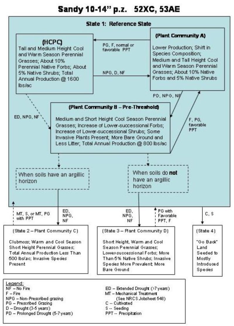
Three important plant communities and the successional pathways within the Reference State (State 1) are shown in the following diagram. In addition, transitions from Community B (State 1) to State 2 (Community C) and State 3 (Community D) are also illustrated. The diagram also depicts a third transition from State 1 (Reference State) to State 4. Ecological processes are discussed in the plant community descriptions, which follow the diagram.
Tall- and medium-height cool- and warm-season perennial grasses, about ten percent perennial native forbs; about 5 percent native shrubs; total annual production is 1600 pounds per acre.
The interpretive plant community for this site is the Historic Climax Plant Community (HCPC). Cool season tall and mid-grasses (such as prairie sandreed grass, western wheatgrass, Indian ricegrass, bluebunch wheatgrass, and needle and thread grass) dominate the HCPC. These native, perennial grasses represent about 80% of the total annual plant production in the community. Little bluestem is uncommon on this site. Bluebunch wheatgrass is the dominant grass on this site.
Less common species in the HCPC include plains muhly, prairie junegrass, threadleaf sedge, plains reedgrass, sandberg bluegrass and blue grama. Dotted gayfeather, and purple and white prairie clovers are important warm season forbs. American vetch may be the most common cool season forb. The group of inconspicuous forbs that should be present in small amounts include scarlet globemallow, penstemon, many-flowered aster, erigeron, scurfpeas, and hairy goldenaster. Total forb production normally represents about 10% of the total annual production.
Silver sagebrush, yucca, prairie rose and western snowberry may occur in the HCPC. Overall, shrubs account for about 5% of the annual plant production.
Range inventory data collected (in 2001 and 2004) on the Fort Peck and Fort Belknap Indian Reservations indicate total above ground production varies from 1,270 to 2,550 lbs/ac. The latter inventory was conducted during a favorable precipitation period, which probably explains why the production is slightly higher than the 1600 lbs/ac which is normally expected on this site. Average annual production is expected to be slightly higher and lower than 1600 lbs/ac, respectively on more mesic and xeric portions of the Glaciated plains. During the inventories on the Reservations, similarity indices (SI) >75% were recorded within the HCPC.
This plant community is well adapted to the glaciated plains. Precipitation is the most important factor influencing production. The functional and structural diversity of plant species (perennials (with a few annuals and biennials), cool and warm season grasses, forbs and shrubs) optimize the capture of solar energy and maximize subsequent plant growth through the efficient use of available soil water and nutrient cycling. Following a disturbance which reduces the competitiveness of the species at HCPC, the taller, warm and cool season grasses (Indian ricegrass, bluebunch wheatgrass, western/thickspike wheatgrass) decrease. They are replaced by shorter height species such as needle and thread, blue grama, sand dropseed, and fringed sagewort. With further disturbance, annual bromes, wooly plantain, fluffgrass, and red threeawn become conspicuous. With proper grazing management and non-drought conditions, the HCPC species will replace these lower successional species within a few years.
Basal plant cover averages 35%. Litter is in contact with about 60% of the soil surface. Less than 5% of the soil surface should be bare, or unprotected by litter, rock, moss, and plant canopy. Bare ground should be less than 2 inches in diameter. Rills should not be present and water flow patterns should be barely observable.
The major plant species composition and production by dry weight are shown for the HCPC in the following table. Total annual production has been derived from several sources, and has been adjusted to represent a typical annual precipitation cycle.
Figure 7. Annual production by plant type (representative values) or group (midpoint values)
Table 6. Annual production by plant type
Plant type
Low (lb/acre)
Representative value (lb/acre)
High (lb/acre)
Grass/Grasslike
840
1380
1750
Forb
110
140
150
Shrub/Vine
50
80
100
Total
1000
1600
2000
Table 7. Ground cover
Tree foliar cover
0%
Shrub/vine/liana foliar cover
0%
Grass/grasslike foliar cover
0%
Forb foliar cover
0%
Non-vascular plants
0-5%
Biological crusts
0-2%
Litter
40-60%
Surface fragments >0.25" and <=3"
0-3%
Surface fragments >3"
0-1%
Bedrock
0%
Water
0%
Bare ground
0-1%
Table 8. Soil surface cover
Tree basal cover
0%
Shrub/vine/liana basal cover
1-2%
Grass/grasslike basal cover
25-30%
Forb basal cover
1-5%
Non-vascular plants
0%
Biological crusts
0%
Litter
0%
Surface fragments >0.25" and <=3"
0%
Surface fragments >3"
0%
Bedrock
0%
Water
0%
Bare ground
0%
Table 9. Canopy structure (% cover)
Height Above Ground (ft)
Tree
Shrub/Vine
Grass/ Grasslike
Forb
<0.5
–
0-20%
0-10%
0-40%
>0.5 <= 1
–
0-40%
0-30%
0-50%
>1 <= 2
–
0-30%
0-40%
0-8%
>2 <= 4.5
–
0-10%
0-20%
0-2%
>4.5 <= 13
–
–
–
–
>13 <= 40
–
–
–
–
>40 <= 80
–
–
–
–
>80 <= 120
–
–
–
–
>120
–
–
–
–
Community 1.2 Increaser co-dominant
Lower production; shift in species composition; medium- and tall-height cool- and warm-season perennial grasses; about ten percent native forbs and five percent native shrubs.
Total plant production averages about 1200 lbs/ac in this Plant Community, or 75% of the production at the HCPC. Production of the tall, cool and warm season perennial bunchgrasses (green needlegrass, and bluebunch wheatgrass) decreased from the HCPC. In contrast, production of the medium height rhizomatous western/thickspike wheatgrasses and the lower-successional needle and thread grass increased. In comparison to the HCPC, the relative production of short height grasses and sedges such as blue grama, prairie junegrass, plains reedgrass and threadleaf sedge increased to about 20% of the total plant production. Sand dropseed may show up in some communities. Exact response by these species varies with the kind of disturbance (drought, grazing, etc.) and with precipitation (amount and timing).
Native forb production continues to account for about 10% of the total production. However, scurfpeas and hairy goldenaster increase at the expense of the prairie clovers and American vetch. Shrubs account for less than 10% of the total production. However, the half-shrub fringed sagewort often increases. These increases following disturbance are due to enhanced growth of established plants and seedling recruitment. Not only do individual plants that survive the disturbance grow bigger and produce more seed, but seed is dispersed beginning in summer and continued through the winter (Bai and Romo 1997). SI indices from 55-75% are associated with this community. Litter cover decreases to 50% and bare ground increases to 5-10%. In contrast to the HCPC, range conservationists have slight to moderate concerns regarding plant functional/structural group shifts, decreasing amount of litter, and increased presence of lower successional plants.
Community 1.3 Increaser dominant, at risk
Medium- and short-height cool-season perennial grasses; increase of lower-successional forbs; increase of lower-successional shrubs; some invasive plants present; more bare ground, and less litter; total annual production is 800 pounds per acre.
Plant Community B is dominated by a mix of cool and warm season perennial grasses such as needle and thread, western/thickspike wheatgrass, blue grama, plains reedgrass, prairie junegrass and upland sedges. Only a few individual plants of bluebunch wheatgrass, green needlegrass and little bluestem remain in the Community. The short grass and grasslike plants make up more than 30% of the total production. Total vegetative production declines to about 900 lbs/ac in a normal year.
Hairy goldenaster, scarlet globemallow, scurfpeas and other warm season forbs increase at the expense of the prairie clovers and American vetch. Green sagewort and fringed sagewort, a half-shrub, increases at the expense of winterfat and other desirable forage species. Forbs and shrubs, respectively account for more than 10% and 5% of the total plant production. SI indices for this community vary from 45-55%.
Plant basal cover varies from 20-25%. Litter provides cover for about 35-40% of the ground, while bare ground increases to 10-15%. An examination of the soil surface suggests that there is inadequate regeneration of desired species, inadequate vigor of key species, and possible increases in amount of bare ground.
Plant Community B is fairly resilient, but it is not highly resistant to disturbance. It is the “pre-threshold” community. Therefore, it is critical that this community be recognized and strategies implemented to prevent further regression. Community B can readily regress to a lower state, from which succession back to the HCPC community or Plant Community A would be restricted.
Pathway 1.1a Community 1.1 to 1.2
Non-prescribed grazing, drought (3 to 5 years), and no fire
Successional pathways from the HCPC are influenced by frequency, timing and intensity of grazing, amount and timing of precipitation, fire, insect infestations, colonization and recruitment of noxious weeds, etc. As communities regress from HCPC, short warm and cool season grasses increase at the expense of mid and tall cool season grasses.
Pathway 1.1b Community 1.1 to 1.3
Extended drought (greater than 7 years), non-prescribed grazing, no fire
Pathway 1.2a Community 1.2 to 1.1
Prescribed grazing, fire, normal or favorable precipitation
Plant Community A is resilient. Successional processes can return Plant Community A to the HCPC. The process is facilitated by prescribed grazing, the incorporation of the natural fire regime into the system, and by normal precipitation.
Pathway 1.2b Community 1.2 to 1.3
Prolonged drought (5 to 7 years), non-prescribed grazing, no fire
Prolonged drought, non-prescribed grazing, and the continued absence of fire in the system causes retrogression to Community B. The effects of drought and poor grazing management are readily apparent with careful observation.
Pathway 1.3a Community 1.3 to 1.2
Fire, prescribed grazing, favorable precipitation
Favorable precipitation, prescribed grazing and a normal fire regime are normally required for succession to higher communities (HCPC and/or Plant Community A). Management strategies should focus on proper utilization and grazing deferment to increase vigor and seed production of desirable plants, and to increase litter cover.
State 2 Clubmoss State
Community 2.1 Clubmoss short-grass
Clubmoss; warm- and cool-season short-height perennial grasses; total annual production less than 500 pounds per acre; invasive species present.
Community C occurs on this site when there is an argillic horizon present.
Clubmoss, blue grama, prairie junegrass, sandberg bluegrass, and other short grasses dominate this community. Although some western wheatgrass persists as single shoots with few seed stalks, it is difficult to find green needlegrass, little bluestem and bluebunch wheatgrass. Japanese brome and cheatgrass often occur in this community.
Wooly plantain, hoods phlox, hairy goldenaster and western yarrow are common forbs. Fringed sagewort (a half-shrub) usually increases while the shrubs decrease in abundance. Total vegetative production averages about 550 lbs/ac.
Dense clubmoss was present at 50% of the data collection plots located on the Sandy Site during the range inventories on the Fort Peck and Belknap Reservations in 2001-2004. In some cases, it formed a mat-like carpet with 20-70% ground Cover. The presence of clubmoss on these sites is indicative of an argillic horizon. There are very few seedlings of desirable species emerging through the clubmoss. Some researchers hypothesize that this is due to an inadequate seedbank (Romo and Bai 2004). SI indices of less than 25% are associated with Community C.
Soil erosion is normally not a serious problem because of the cover provided by clubmoss. However, NRCS specialists often reported that they were concerned about inadequate litter, slight surface erosion by water, and noxious plants. The clubmoss disrupts the hydrologic cycle (capture, storage and redistribution of precipitation) by impeding infiltration and percolation. Less vegetative growth is available for transfer to litter, and nutrient cycling is delayed or impeded.
In comparison to the State 1 communities, State 2 is less efficient in capturing solar energy and converting it to carbohydrates for plant growth. The absence of tall and mid cool season perennial grasses, plus the shift from cool season plants to warm season plants, indicates that the structural and functional processes of the site have been disrupted.
State 3 Short-grass State
Community 3.1 Short-grass dominant
Short-height, warm- and cool-season perennial grasses; lower-successional forbs; more than five percent native shrubs; invasive species more prevalent; more bare ground.
Plant Community D occurs on soils that do not have an argillic horizon. This Community is dominated by blue grama, prairie junegrass, sandberg bluegrass, threadleaf sedge, and other short grasses and grass-like plants. Western wheatgrass and needle and thread are minor components of the community.
Clubmoss is present on many sites, but is much less dominant than in State 2. Hoods phlox, wooly plantain, hairy goldenaster, cudweed sagewort, and scarlet globemallow are common forbs. Fringed sagewort is a common half-shrub. Broom snakeweed and prickly pear cactus increase in response to the more xeric environment (less plant cover, less litter, more evaporative losses, lower humidity, etc.). Total vegetative production averages about 650 lbs/ac. SI indices of 15-35% are associated with this community.
In contrast to communities in State 1, range conservationists express moderate to extreme concerns about plant community composition, functional/structural groups, litter, annual production, and invasive plants. Each of the primary processes: 1) hydrology (the capture, storage and redistribution of precipitation), 2) energy capture (conversion of sunlight to plant and animal matter), and 3) nutrient cycling (the cycle of nutrients through the physical and biotic components of the environment) has been degraded beyond the point of self-repair within a reasonable length of time and without external inputs of energy. For example, when tall, high producing, perennial grasses are replaced by short grasses (blue grama, clubmoss and prairie junegrass), the abilities of the plant community to maximize the conversion of solar energy to plant biomass and efficiently utilize available precipitation are impaired. Less solar energy is captured and converted to plant carbohydrates. Plant productivity declines, and there are fewer plants and less litter to protect the soil. As bare ground increases, infiltration decreases and/or surface runoff and soil evaporation increases. Because ecological processes of the site are no longer balanced and sustained, shallow rooted, warm season species continue to gain a competitive advantage over the tall, deep rooted, perennial species. The biotic integrity of the site is degraded. Thus, the regression from Community B to either State 2 or State 3 crosses a threshold. Thresholds are defined as a point in space and time at which one or more of the primary ecological processes responsible for maintaining the sustained equilibrium of the state degrades beyond the point of self-repair.
State 4 Seeded State
Community 4.1 Go Back Land
Seeded to mostly introduced species.
More than a million acres of former cropland in the Glaciated Plains are seeded to introduced and native species. These seedings resulted from Society’s concerns regarding land stewardship and erosion, and have been largely funded by the Federal Government. The government programs have spanned from the 1940’s (Bankhead Jones Act) to the present (Conservation Reserve Program-CRP).
Crested wheatgrass was the primary species seeded under the direction of the Bankhead Jones Act. Crested wheatgrass, intermediate and pubescent wheatgrasses, smooth bromegrass, and some native grasses were seeded during the Soil Bank Programs of the 1960-1970 era. Both introduced and native species were seeded during the CRP program (1985-present). There are over 220,000 acres of CRP in Valley County alone.
The future of these “go back lands” is not predicted in the state and transition model. Depending on government programs and agricultural prices, these lands could stay in permanent vegetation with limited haying and grazing, be fully used as pasture for grazing livestock, or be converted to cropland.
Transition T1A State 1 to 2
Extended drought (greater than 7 years), non-prescribed grazing, no fire
Any combination of extended drought, non-prescribed grazing and unfavorable climatic patterns can cause regression from Plant Community B to lower States. Soil scientists have observed that the presence of an argillic horizon in the soil will normally result in State 2. When soils do not have an argillic horizon, regression usually leads to State 3. These relationships may not occur in all communities or locations (Van Dyne and Vogel 1967).
Context dependence. When soils have an argillic horizon
Transition T1B State 1 to 3
Extended drought (greater than 7 years), non-prescribed grazing, no fire
Any combination of extended drought, non-prescribed grazing and unfavorable climatic patterns can cause regression from Plant Community B to lower States. Soil scientists have observed that the presence of an argillic horizon in the soil will normally result in State 2. When soils do not have an argillic horizon, regression usually leads to State 3. These relationships may not occur in all communities or locations (Van Dyne and Vogel 1967).
Context dependence. When soils do not have an argillic horizon
Transition T1C State 1 to 4
Cultivated, Seeding
Restoration pathway R2A State 2 to 1
Mechanical treatment (see NRCS Job sheet 548), Seeding, or mechanical treatment, prescribed grazing with precipitation.
The implementation of prescribed grazing, re-implementation of the natural fire regime and a favorable precipitation pattern normally will not induce succession from States 2 and 3. Succession from these States back to State 1 usually requires a significant input of energy.
Mechanical treatments are often used to induce and facilitate succession on this ecological site. Mechanical treatments should not be used on slopes greater than 10% (See NRCS Conservation Practice 548). Although seeding normally is not recommended following a mechanical treatment, the absence of key species may make it necessary to seed following treatment in State 2. Because wind erosion is a concern, a long-term comprehensive management plan is essential to the successful management of these states. Without adequate grazing deferment following treatment and a prescribed grazing plan, the desired effects of mechanical treatment will not be achieved. Failure to follow a comprehensive plan may result in economic losses (Kulshreshtha et al 2002). Although Kulshreshtha et al concluded that mechanical treatments were not economically feasible in Saskatchewan, experience along Montana’s Highline suggests otherwise. With prescribed grazing and plant succession, the effective life of treatment should be greater than 10 years (life expectancy used by researchers).
Range seeding is usually not necessary following mechanical treatment of State 3. The number of desired plants (and seed) is usually adequate to facilitate succession.
The necessity of proper management should not be overlooked on this productive ecological site. Research has documented succession occurring, during favorable precipitation cycles, in many Northern Great Plains plant communities. Experience indicates that fire (if there is adequate fuel) reduces clubmoss cover. At locations where the surface soil is intact and has not been adversely impacted by erosion, prolonged favorable climatic conditions combined with proper management may induce succession from Plant Communities C and D across the threshold (to State 1). It is theorized that the significant input of energy that is normally required to move succession across a threshold may not be needed.
Restoration pathway R3A State 3 to 1
Prescribed grazing with favorable precipitation, fire
The implementation of prescribed grazing, re-implementation of the natural fire regime and a favorable precipitation pattern normally will not induce succession from States 2 and 3. Succession from these States back to State 1 usually requires a significant input of energy.
Mechanical treatments are often used to induce and facilitate succession on this ecological site. Mechanical treatments should not be used on slopes greater than 10% (See NRCS Conservation Practice 548). Although seeding normally is not recommended following a mechanical treatment, the absence of key species may make it necessary to seed following treatment in State 2. Because wind erosion is a concern, a long-term comprehensive management plan is essential to the successful management of these states. Without adequate grazing deferment following treatment and a prescribed grazing plan, the desired effects of mechanical treatment will not be achieved. Failure to follow a comprehensive plan may result in economic losses (Kulshreshtha et al 2002). Although Kulshreshtha et al concluded that mechanical treatments were not economically feasible in Saskatchewan, experience along Montana’s Highline suggests otherwise. With prescribed grazing and plant succession, the effective life of treatment should be greater than 10 years (life expectancy used by researchers).
Range seeding is usually not necessary following mechanical treatment of State 3. The number of desired plants (and seed) is usually adequate to facilitate succession.
The necessity of proper management should not be overlooked on this productive ecological site. Research has documented succession occurring, during favorable precipitation cycles, in many Northern Great Plains plant communities. Experience indicates that fire (if there is adequate fuel) reduces clubmoss cover. At locations where the surface soil is intact and has not been adversely impacted by erosion, prolonged favorable climatic conditions combined with proper management may induce succession from Plant Communities C and D across the threshold (to State 1). It is theorized that the significant input of energy that is normally required to move succession across a threshold may not be needed.
Additional community tables
Table 10. Community 1.1 plant community composition
Livestock Management
This site evolved with trampling and defoliation (bison, elk, deer, antelope, prairie dogs, grasshoppers, jackrabbits, and other herbivores), fire and drought. The site is highly resistant to disturbances which may alter its ecological processes. It is also resilient. Following perturbations such as drought, which allows blue grama and other increasers to increase at the expense of the mid and tall grasses, succession occurs with subsequent rainfall. Thus, the HCPC, or Communities A or B may be present at any given time in State 1. The site has the potential to produce 1,600 lbs/ac.
Forage production shows far greater variations in response to changes in annual precipitation than to different grazing intensities (Heitschmidt et al. 2005). However, proper stocking rates and prescribed grazing is needed to ensure that the site remains in State 1. Without proper grazing management the mid-to-tall grass community will regress to a blue grama, prairie junegrass, dense clubmoss community. In comparison to the HCPC, suggested stocking rates for communities in States 2 and 3 represent a four-fold reduction. Experience indicates that prescribed grazing prevents further deterioration in States 2 and 3. However, prescribed grazing normally will not guarantee significant plant succession (in States 2 and 3) unless the clubmoss and blue grama sod is reduced by mechanical treatments. Very few livestock losses are reported from poisonous plants.
Wildlife Interpretations
The Sandy 10-14” p.z. ecological site that is in a high seral state or HCPC (State 1) provides forage for mule deer and antelope during most of the year. However, the overall forage potential is limited by the relatively low production and diversity of forbs and shrubs. Low shrub cover also limits the potential of the site for thermal and escape cover. Most deer use occurs along the edges of the site where it borders woody draws, badland range sites, etc.
Species diversity and cover associated with either the high seral or HCPC states also provide habitat for sharp-tailed grouse and other upland birds. Most wildlife usage occurs along the transitions between the sandy site and woodland draws. The relative absence of big sagebrush and silver sagebrush limits the potential of this site for sage grouse habitat.
Species diversity and litter also provide favorable habitats for deer mice, rabbits and other small mammals. Golden eagles, redtail and ferruginous hawks are often circling over the landscape searching for prey.
Communities that are in States 2 and 3 are much less suitable for big game, upland birds and most species of small mammals. However, they are more suitable for prairie dogs. Prairie dog towns also have potential for use by burrowing owls, mountain plovers, and other wildlife species. Lands in State 4 that were seeded under the CRP program provide valuable forage and cover for upland birds, deer and antelope,
Plant Preferences by Animal Kind
Refer to NRCS Field Office Technical Guide, Section IIE, General Information, for tables displaying plant preferences by livestock and wildlife.
Hydrological functions
Soils associated with this ecological site are mostly in Hydrologic Soil Group B (with a few in Groups A and C). Infiltration rates are generally moderate. The runoff potential is also low to moderate, depending on slope and ground cover.
Good hydrologic conditions exist on plant communities that are either in a high seral state or are at HCPC (State 1). Canopy cover (grass, forbs and shrubs) is greater than 90 percent in these communities, which is conducive to high infiltration rates and minimizes runoff and erosion.
Communities in early seral states (States 2 and 3) are generally considered to be in poor hydrologic condition. Concerns are valid. The dense clubmoss and blue grama restrict the ability of the desirable tall and mid-grasses to utilize available moisture. Although erosion is probably minor at locations where the site produces mid and tall, cool-season grasses, or a dense clubmoss and blue grama, wind and water erosion is a major concern when the amount of bare ground exceeds litter. Excess bare ground results when States 2 and 3 have been subjected to excessive grazing by livestock, prairie dogs, insects, extreme drought or wildfire.
Recreational uses
Hunters are probably the most common recreational user of this ecological site. The site is also used by hikers and photographers. Many “classy” photographs of the Northern Great Plains exploit the stark and contrasting beauty of yuccas, little bluestem and/or prairie sandreed.
Wood products
This site has no significant value for wood products.
Other products
This site is suitable for livestock grazing from May through October. Because tall and mid grasses comprise about 85 percent of the production, the site is better-suited for cattle, rather than sheep grazing.
Other information
The Sandy 10-14” p.z. ecological site in the central Glaciated plains is resistant to perturbations. However, the site loses its resiliency when the plant community regresses from a high to an early seral state. As the site moves from HCPC to lower seral communities, reproductive capability of the higher successional plants is restricted. Annual production in early seral states is less than 25 percent of the sites’ potential, which adversely affects amount of litter and the number of structural/functional plant groups.
Supporting information
Inventory data references
Data Source Number of Records Sample Period State County
SCS-Range-417 7 2002 MT Roosevelt
ECS-1
Modified Double Sampling 6 2001-2004 MT Blaine, Roosevelt, Sheridan,
Phillips, Valley
USDA-SCS-MT (1981) Technical Range Site Description
Other references
Bai, Yuguang, and J. T. Romo. 1997. Seed production, seed rain, and the seedbank of fringed sagebrush. J.. Range Manage. 50:151-155.
Briske, D. D., S. D. Fuhlendorf, and F. E. Smiens. 2005. State-and-transition models, thresholds, and rangeland health: a synthesis of ecological concepts and perspectives. Rangelands Ecol. Manage. 58:1-10.
Frost, Cecil C. 1998. Presettlement fire frequency regimes of the United States: a first approximation. Pages 70-81 in Teresa L. Pruden and Leonard A. Brennan (eds.). Fire in ecosystem management: shifting the paradigm from suppression to prescription. Tall Timbers Fire Ecology Conference Proceedings, No. 20. Tall Timbers Research Station, Tallahassee, Fl.
Heitschmidt, R. K., K. D. Klement, and M. R. Haferkamp. 2005. Interactive effects of drought and grazing on Northern Great Plains rangelands.Rangeland Eco. Manage. 58:11-19.
Kulshreshtha, S. N., J. T. Romo, and Peng Hongjia. 2002. Economic analysis of mechanically disturbing rangeland to reduce clubmoss in Saskatchewan. Can.J. Plant Sci. 82:739-746.
Romo, J. T., and Y. Bai. 2004. Seed bank and plant community composition, mixed prairie of Saskatchewan. J. Range Manage. 57:300-304.
USDA NRCS. 1997. National Range and Pasture Handbook.
Van Dyne, G. M., and W. G. Vogel. 1967. Relation of Selaginella densa to site, grazing, and climate. Ecol. 48:438-444.
Contributors
Kirt Walstad
Approval
Kirt Walstad, 5/14/2024
Acknowledgments
Site Description Revisions
The 2005 Sandy 10-14” p.z. ecological site description replaces earlier dated versions of the Sandy 10-14” p.z. description in Rangeland Resource Unit 52XC. This 2005 revision incorporates the State and Transition Model theory, additional data on site productivity, and an improved understanding of many rangeland health indicators.
Site Description Approval
This ecological site description is approved with the understanding that it is no more than another step in our continual effort to update the NRCS technical guide. In order to facilitate the process, NRCS field personnel are encouraged to forward existing information and/or new data that can be used to improve the utility of this site description. Please forward the information and data to the State Rangeland Management Specialist.
Authors Date Approval Date
Dr. John Lacey 02/28/2005 Loretta J. Metz 03/19/2005
Maxine Rasmussen, Area RMS, Glasgow, MT
Jon Siddoway, Area RMS, Great Falls, MT
Rick Bandy, Area RSS, Great Falls, MT
Greg Snell, Area RSS, Glasgow, MT
Rangeland health reference sheet
Interpreting Indicators of Rangeland Health is a qualitative assessment protocol used to
determine ecosystem condition based on benchmark characteristics described in the Reference Sheet. A suite of 17 (or
more) indicators are typically considered in an assessment. The ecological site(s) representative of an assessment
location must be known prior to applying the protocol and must be verified based on soils and climate. Current plant
community cannot be used to identify the ecological site.
Author(s)/participant(s)
Loretta Metz, Maxine Rasmussen, Jon Siddoway
Contact for lead author
Area Rangeland Management Specialist, Glasgow Area Office, MT
Reference site used? No
Date
05/04/2005
Approved by
Kirt Walstad
Approval date
Composition (Indicators 10 and 12) based on
Annual Production
Indicators
Number and extent of rills:
Rills should not be present in HCPC. If in plant community A, careful examination will yield slight evidence of rills that are less than ½ inch deep, linear, but short in length. If in plant community B, rills would be visible, ½ inch deep or more, linear, rarely exceeding 1 foot in length. Distance between rills is irregular. If in plant community B, rills would be visible.
Presence of water flow patterns:
Water flow patterns should not be observable in HCPC. If in plant community A, careful examination will yield short discontinuous water flow patterns. If in plant community B, water flow patterns would be visible as long (more than 1-foot) and continuous across the landscape.
Number and height of erosional pedestals or terracettes:
Pedestals are nonexistent in HCPC. If in plant community A, careful examination on slopes > 8% yield occasional pedestals and terracettes approximately ¼ inch above the soil surface. If in plant community B on slopes > 8%, pedestals and terracettes are frequent and ½ - ¾ inch above the soil surface.
Bare ground from Ecological Site Description or other studies (rock, litter, lichen, moss, plant canopy are
not bare ground):
Less than 5% of the soil surface should be bare in HCPC. Bare ground should be less than 2” in diameter. If in plant community A, 5-10% of the soil surface can be exposed. If in plant community B, 20% of the soil surface can be exposed.
Number of gullies and erosion associated with gullies:
None.
Extent of wind scoured, blowouts and/or depositional areas:
None.
Amount of litter movement (describe size and distance expected to travel):
Litter movement is not expected with HCPC or plant community A. If in plant community B, litter, both fine and coarse, movement is visible, especially on slopes > 8%, but the distance moved is less than 1 foot.
Soil surface (top few mm) resistance to erosion (stability values are averages - most sites will show a range
of values):
Stability class anticipated to be 2 to 4 if the surface texture is sandy loam and 5 or 6 is the surface texture is fine sandy loam or loamy find sand.
Soil surface structure and SOM content (include type of structure and A-horizon color and thickness):
The surface layer is 1-9” thick. The color ranges from light brownish gray, grayish brown, dark grayish brown and dark brown. Surface textures include fine sandy loam, sandy loam and loamy fine sand. Soil organic matter ranges from 0.5-4.0%.
Effect of community phase composition (relative proportion of different functional groups) and spatial
distribution on infiltration and runoff:
In HCPC, 95% plant canopy and 80-85% basal cover with small gaps between plants should reduce raindrop impact and slow overland flow, providing increased time for infiltration to occur. Healthy, deep rooted native grasses enhance infiltration and reduce runoff. Infiltration rate is rapid. If in plant community A, 90-95% plant canopy and 70-80% basal cover with small gaps between plants will still reduce raindrop impact and decrease overland flow. If in plant community B, 40-70% plant canopy and 50-75% basal cover with moderate gaps between plants, intensifies raindrop impact and increases overland flow. The site tends to be more xeric as runoff increases.
Presence and thickness of compaction layer (usually none; describe soil profile features which may be
mistaken for compaction on this site):
None.
Functional/Structural Groups (list in order of descending dominance by above-ground annual-production or live foliar
cover using symbols: >>, >, = to indicate much greater than, greater than, and equal to):
Dominant:
Sub-dominant:
Other:
Additional:
HCPC: Tall stature, warm season rhizomatous grasses > mid-stature, warm season bunchgrasses grasses> mid stature, warm season bunch grasses > forbs >shrubs. Plant community A: Mid-stature, cool season bunch grasses > mid-stature, cool season rhizomatous grasses> short stature, warm season rhizomatous > forbs > shrubs. Plant community B: Mid-stature cool season bunch grasses > mid-stature, cool season rhizomatous grasses > short stature, warm season rhizomatous grasses > forbs > shrubs.
Amount of plant mortality and decadence (include which functional groups are expected to show mortality or
decadence):
Plant mortality and decadence very low in HCPC and Plant community A. In periods of drought, shrubs would exhibit decadence in the state 1 reference communities.
Average percent litter cover (%) and depth ( in):
Litter cover is in contact with soil surface. Litter decreases in Plant community A to 40-50% and depth is reduced to 0.5 inch. Litter decreases to about 15% in Plant community B and is less than ½ inch deep.
Expected annual annual-production (this is TOTAL above-ground annual-production, not just forage annual-production):
1000 - 2000 #/acre from Plant community B to HCPC in the State 1 reference community.
Potential invasive (including noxious) species (native and non-native). List species which BOTH characterize
degraded states and have the potential to become a dominant or co-dominant species on the ecological site if
their future establishment and growth is not actively controlled by management interventions. Species that become
dominant for only one to several years (e.g., short-term response to drought or wildfire) are not invasive
plants. Note that unlike other indicators, we are describing what is NOT expected in the reference state for the
ecological site:
Needle and thread, blue grama, threadleaf sedge, fringed sagewort, green sagewort, plains prickly pear, broom snakeweed, yucca, leafy spurge, dense clubmoss.
Perennial plant reproductive capability:
All species are capable of reproducing in HCPC and Plant community A. In Plant community B, plant seedlings will be weighed in favor of marginal and undesirable species. Replacement of desirable species will be very few.
The Ecosystem Dynamics Interpretive Tool is an information system framework developed by the USDA-ARS Jornada Experimental Range, USDA Natural Resources Conservation Service, and New Mexico State University.
Click on box and path labels to scroll to the respective text.