Provisional. A provisional ecological site description has undergone quality control and quality assurance review. It contains a working state and transition model and enough information to identify the ecological site.
MLRA notes
Major Land Resource Area (MLRA): 052X–Brown Glaciated Plains
The Brown Glaciated Plains, MLRA 52, is an expansive, agriculturally and ecologically significant area. It consists of approximately 14.5 million acres and stretches across 350 miles from east to west, encompassing portions of 15 counties in north-central Montana. This region represents the southwestern limit of the Laurentide Ice Sheet and is considered to be the driest and westernmost area within the vast network of glacially derived prairie pothole landforms of the northern Great Plains. Elevation ranges from 2,000 feet (610 meters) to 4,600 feet (1,400 meters).
Soils are primarily Mollisols, but Entisols, Inceptisols, Alfisols, and Vertisols are also common. Till from continental glaciation is the predominant parent material, but alluvium and bedrock are also common. Till deposits are typically less than 50 feet thick, and in some areas glacially deformed bedrock occurs at or near the soil surface (Soller, 2001). Underlying sedimentary bedrock largely consisting of Cretaceous shale, sandstone, and mudstone (Vuke et al., 2007) is commonly exposed on hillslopes, particularly along drainageways. Significant alluvial deposits occur along glacial outwash channels and major drainages, including portions of the Missouri, Teton, Marias, Milk, and Frenchman Rivers. Large glacial lakes, particularly in the western half of the MLRA, deposited clayey and silty lacustrine sediments (Fullerton et al., 2013).
Much of the western portion of this MLRA was glaciated towards the end of the Wisconsin age, with the maximum glacial extent occurring approximately 20,000 years ago (Fullerton et al., 2004). The result is a geologically young landscape that is predominantly a level till plain interspersed with lake plains and dominated by soils in the Mollisol and Vertisol orders. These soils are very productive and generally are well suited to dryland farming. Much of this area is aridic-ustic. Crop-fallow dryland wheat farming is the predominant land use. Areas of rangeland typically are on steep hillslopes along drainages.
The rangeland, much of which is native mixedgrass prairie, increases in abundance in the eastern half of the MLRA. The Wisconsin-age till in the north-central part of this area typically formed large disintegration moraines with steep slopes and numerous poorly drained potholes. A large portion of Wisconsin-age till occurring on the type of the level terrain that would typically be optimal for farming has large amounts of less-suitable sodium-affected Natrustalfs. Significant portions of Blaine, Phillips, and Valley Counties were glaciated approximately 150,000 years ago during the Illinoisan age. Due to erosion and dissection of the landscape, many of these areas have steeper slopes and more exposed bedrock than areas glaciated during the Wisconsin age (Fullerton and Colton, 1986).
While much of the rangeland in the aridic-ustic portion of MLRA 52 is classified as belonging to the “dry grassland” climatic zone, sites in portions of southern MLRA 52 may belong to the “dry shrubland” climatic zone. The dry shrubland zone represents the northernmost extent of the big sagebrush (Artemisia tridentata) steppe on the Great Plains. Because similar soils occur in both southern and northern portions of the MLRA, it is currently hypothesized that climate is the primary driving factor affecting big sagebrush distribution in this area. However, the precise factors are not yet fully understood.
Sizeable tracts of largely unbroken rangeland in the eastern half of the MLRA and adjacent southern Saskatchewan are home to the Northern Montana population of greater sage-grouse (Centrocercus urophasianus), and large portions of this area are considered to be a Priority Area for Conservation (PAC) by the U.S. Fish and Wildlife Service (U.S. Fish and Wildlife Service, 2013). This population is unique among sage grouse populations in the fact that many individuals overwinter in the big sagebrush steppe (dry shrubland) in the southern portion of the MLRA and then migrate to the northern portion of the MLRA, which lacks big sagebrush (dry grassland), to live the rest of the year (Smith, 2013).
Areas of the till plain near the Bearpaw and Highwood Mountains as well as the Sweetgrass Hills and Rocky Mountain foothills are at higher elevations, receive higher amounts of precipitation, and have a typic-ustic moisture regime. These areas have significantly more rangeland production than the drier aridic-ustic portions of the MLRA and have enough moisture to produce crops annually rather than just bi-annually, as in the drier areas. Ecological sites in this higher precipitation area are classified as the moist grassland climatic zone.
Classification relationships
NRCS Soil Geography Hierarchy
• Land Resource Region: Northern Great Plains
• Major Land Resource Area (MLRA): 052 Brown Glaciated Plains
• Climate Zone: Dry Shrubland
National Hierarchical Framework of Ecological Units (Cleland et al., 1997; McNab et al., 2007)
• Domain: Dry
• Division: Temperate Steppe
• Province: Great Plains-Palouse Dry Steppe Province 331
• Section: Northwestern Glaciated Plains 331D
• Subsection: Montana Glaciated Plains 331Dh
• Landtype Association/Landtype Phase: N/A
National Vegetation Classification Standard (Federal Geographic Data Committee, 2008)
• Class: Xeromorphic Woodland, Scrub and Herb Vegetation Class (3)
• Subclass: Cool Semi-Desert Scrub and Grassland Subclass (3.B)
• Formation: Cool Semi-Desert Scrub and Grassland Formation (3.B.1)
• Division: Cool Semi-Desert Scrub and Grassland Division (3.B.1.Ne)
• Macrogroup: Artemisia tridentata - Artemisia tripartita ssp. tripartita - Purshia tridentata Steppe and Shrubland Macrogroup (3.B.1.Ne.3)
• Group: Artemisia tridentata - Artemisia tripartita - Purshia tridentata Big Sagebrush Steppe and Shrubland Group (3.B.1.Ne.3.b)
• Alliance: Artemisia tridentata ssp. wyomingensis Mesic Steppe and Shrubland Alliance
• Association: Artemisia tridentata ssp. wyomingensis / Pascopyrum smithii Shrub Grassland
This provisional ecological site occurs occurs on till plains, hillslopes, outwash fans, alluvial fans, and high stream terraces where slopes are less than 15 percent. This site is typically on linear or concave backslopes, footslopes, shoulders, or summits.
This site is characterized by moderately deep to very deep (greater than 20 inches to bedrock) medium textured soils. Surface textures are of the fine-loamy or fine-silty textural family (< 35 percent clay) and soils frequently have a mollic epipedon. Calcium carbonate equivalent is less than 5 percent in the upper 5 inches. Characteristic vegetation is Wyoming big sagebrush (Artemisia tridentata subsp. wyomingensis), western wheatgrass (Pascopyrum smithii), and needle and thread (Hesperostipa comata).
This site usually occurs on till plains, but is also found on alluvial fans, and knolls. Slopes vary from 1-15%, but are usually less than 8%. Elevations generally range from 2,000 to 3,500 feet.
Table 2. Representative physiographic features
Landforms
(1) Hill (2) Till plain (3) Alluvial fan
Runoff class
Very low to medium
Flooding duration
Brief (2 to 7 days)
Flooding frequency
None to rare
Ponding frequency
None
Elevation
2,000–3,500 ft
Slope
1–8%
Aspect
Aspect is not a significant factor
Table 3. Representative physiographic features (actual ranges)
Runoff class
Not specified
Flooding duration
Not specified
Flooding frequency
Not specified
Ponding frequency
Not specified
Elevation
1,875–3,800 ft
Slope
1–15%
Climatic features
A semi-arid, temperate climate characterizes the Glaciated Plains. The predominance of cool season species has evolved to take advantage of the precipitation regime that peaks in late spring-early summer (June). Seventy-five percent of the annual precipitation usually falls as steady, soaking, frontal system rains. Summer rains usually come with thunderstorms. Precipitation is the most important factor influencing production (Heitschmidt et al 2005). Severe drought occurs on average in two out of every ten years (Cooper, et al., 2001).
Table 4. Representative climatic features
Frost-free period (characteristic range)
85-123 days
Freeze-free period (characteristic range)
116-142 days
Precipitation total (characteristic range)
10-14 in
Frost-free period (average)
94 days
Freeze-free period (average)
125 days
Precipitation total (average)
12 in
Characteristic range
Actual range
Bar
Line
Figure 1. Monthly precipitation range
Characteristic range
Actual range
Bar
Line
Figure 2. Monthly minimum temperature range
Characteristic range
Actual range
Bar
Line
Figure 3. Monthly maximum temperature range
Bar
Line
Figure 4. Monthly average minimum and maximum temperature
Figure 5. Annual precipitation pattern
Figure 6. Annual average temperature pattern
Climate stations used
(1) CHESTER [USC00241692], Chester, MT
(2) GLASGOW [USW00094008], Glasgow, MT
(3) HAVRE CITY CO AP [USW00094012], Havre, MT
(4) SHELBY [USC00247500], Shelby, MT
Influencing water features
This site is not influenced by water from streams.
Wetland description
This site is not influenced by water from wetlands.
Soil features
These soils formed from glacial till. The surface layer of these soils varies from 0-7 inches in depth and are typically loam, silt loam, gravelly loam, clay loam, silty clay loam or sandy clay loam. Underlying layers are often clay loams, loams or silty clay loams. Soils are well drained, and are more than 20 inches deep to bedrock. Permeability varies from very slow to slow. Soil ph varies from 6.1-8.4.
Table 5. Representative soil features
Parent material
(1) Till (2) Alluvium
Surface texture
(1) Loam
(2) Silt loam
(3) Clay loam
Family particle size
(1) Fine-loamy
Drainage class
Well drained
Permeability class
Moderately slow to moderate
Soil depth
20–78 in
Surface fragment cover <=3"
Not specified
Surface fragment cover >3"
1%
Available water capacity (Depth not specified)
5–7 in
Electrical conductivity (Depth not specified)
2 mmhos/cm
Soil reaction (1:1 water) (Depth not specified)
6.1–8.4
Subsurface fragment volume <=3" (Depth not specified)
4–11%
Subsurface fragment volume >3" (Depth not specified)
2–5%
Ecological dynamics
This ecological site developed through time under the influence of climate, geological parent material, fire, plants and animals. Research consistently shows that precipitation is the principal factor altering productivity on ecological sites in the Northern Great Plains (Heitschmidt et al. 2005). The same authors concluded that grazing reduces herbage standing crop, whereas its effects on above ground net primary production varies with timing of grazing and precipitation events, along with the functional and structural composition of the plant community.
It is theorized that these lands burned on a natural interval of 5-7 years (Frost 1998). Fires were ignited by lightning and by Early Americans who were attempting to manipulate the environment.
The resultant historic climax plant community (HCPC) is the basis for plant community interpretations. The HCPC was determined by evaluating rangeland relic areas, and other areas protected from excessive disturbance. The HCPC is comprised of a mixture of cool and warm season grasses, forbs and shrubs. About 85% of the annual production is from grasses and sedges, most of which is produced during the cool season. Forbs and shrubs contribute 10% and 5%, respectively, to total annual production. Total vegetative production averages 1600 lbs/ac during normal years.
This site is resistant and resilient to disturbance. Departures in the HCPC are brought about by management actions, drought, a change in the natural fire regime, colonization and recruitment of noxious weeds, etc. The integrity of the site can be readily damaged with the continued absence of prescribed grazing and during prolonged drought. As the HCPC regresses to lower seral stages, the deep-rooted perennial grasses are replaced by blue grama, sandberg bluegrass, fringed sagewort, hoods phlox, threadleaf sedge, hairy goldenaster, and dense clubmoss. The dominance of these “lower-successional” species in the plant community disrupts ecological processes, impairs the biotic integrity of the site, and restricts the system’s ability to recover to higher seral states. The potential of succession back to the HCPC varies with the interaction of all environmental factors.
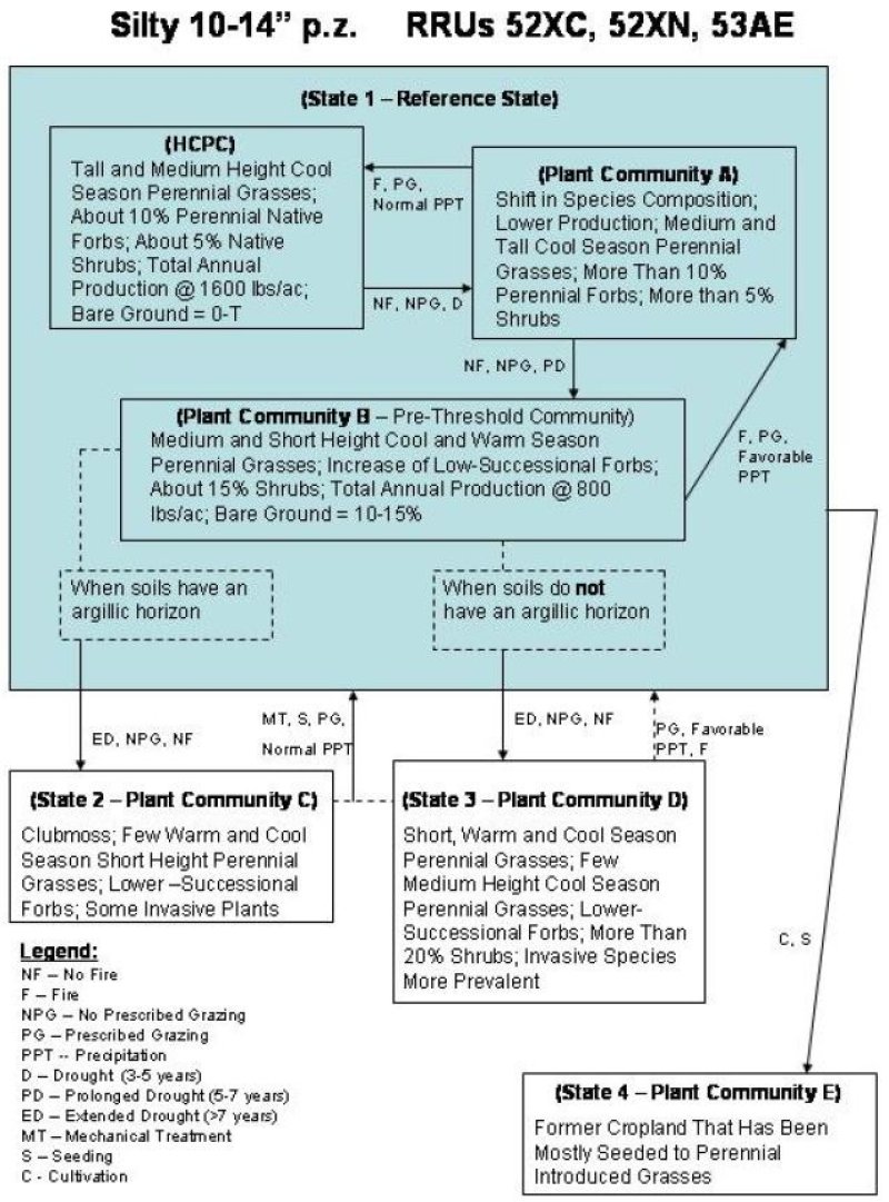
State and Transition Diagram
Trends in plant community dynamics, states, transitional pathways and thresholds have been evaluated and determined through experience and research. Successional pathways of the Silty 10-14” p.z. ecological site cannot be satisfactorily described using traditional theories of plant succession leading to a single climax community (Briske et al. 2005). As the HCPC regresses to an early seral state, it is theorized that a threshold is crossed somewhere within the mid-seral state. Plant communities occurring below this threshold are in a steady state. Succession back to the HCPC does not occur within a reasonable length of time, and/or without a large input of energy.
Three plant communities and the successional and regressional pathways that commonly occur within the Reference State (State 1) are shown in the following diagram. In addition, the transitions from Plant Community B (State 1) to State 2 (Plant Community C) and State 3 (Plant Community D) are also illustrated. A third transition denotes the pathway from State 1 to an introduced perennial grass seeding (State 4). Ecological processes are discussed in the plant community descriptions, which follow the diagram.
Community 1.1 Historic Climax Plant Community (HCPC)
Tall- and medium-height cool-season perennial grasses, about 10 percent perennial native forbs, about 5 percent native shrubs, total annual production at 1600 lbs/ac, bare ground equals zero to trace
Tall- and medium-height cool-season perennial grasses, about 10 percent perennial native forbs, about 5 percent native shrubs, total annual production at 1600 lbs/ac, bare ground equals zero to trace.
The interpretive plant community for this site is the Historic Climax Plant Community (HCPC). Cool season tall and mid-grasses (such as green needlegrass, western wheatgrass, thickspike wheatgrass, porcupine grass and needle and thread grass) dominate the HCPC. These cool season grasses represent about 75% of the total annual plant production in the community. Bluebunch wheatgrass is often the dominant species on the Silty 10-14” p.z. site in the northern Glaciated Plains.
Prairie junegrass, upland sedges and plains reedgrass (cool season species) and blue grama (a warm season species) also occur in the HCPC. Dotted gayfeather, scurfpeas, prairie clovers and other forbs make up less than 10% of the annual production. American vetch, groundplum milkvetch, purple and white prairie clover and scurfpea are important because of their ecological role in the nitrogen cycle.
Winterfat is the most prevalent shrub and is also a valuable forage plant for wildlife and livestock forage, but it seldom produces more than 80 lbs/ac in any community. Silver sagebrush and western snowberry commonly occur in the lower landscape positions of this site. They have some value for wildlife but tend to be restricted to lower landscapes that may benefit from rare flooding and livestock forage. Overall, shrubs account for about 5% of the annual plant production.
Range inventory data collected (in 2001 and 2004) on the Fort Peck and Fort Belknap Indian Reservations indicate total above ground production varies from 1,270 to 2,550 lbs/ac. The scheduling of the inventories coincided with favorable precipitation cycles. Therefore, it is recommended that Thus, total annual production averages 1600 lbs/ac during normal years. Production varies from 1100 lbs/ac in unfavorable years to 2000 lbs/ac during favorable years. Average annual production is expected to increase and decrease, respectively on more mesic and xeric portions of the Glaciated plains. Similarity indices (SI) greater than 75% were recorded within the HCPC.
This plant community is well adapted to the glaciated plains. Precipitation is the most important factor influencing production (Heitschmidt et al 2005). The functional and structural diversity of plant species (annuals, perennials, cool and warm season grasses, forbs and shrubs) optimize the capture of solar energy and maximize subsequent plant growth through the efficient use of available soil water and nutrient cycling. Following a prolonged disturbance which reduces the competitiveness of tall bunchgrasses, production of rhizomatous mid-grasses and short grasses increase. When disturbances are sustained for a prolonged period, woolly plantain, annual bromes or other annual species may invade a community. With proper grazing management and normal precipitation, these invader species normally do not persist for more than a few years.
Litter covers about 60% of the soil surface. Bare ground varies from 0 to Trace.
Rills should not be present and water flow patterns should be barely observable.
Runoff and soil erosion increase as the HCPC regresses to earlier seral states.
The major plant species composition and production by dry weight are shown for the HCPC in the following table. Total annual production has been derived from several sources, and has been adjusted to represent a typical annual precipitation cycle.
Figure 7. Annual production by plant type (representative values) or group (midpoint values)
Table 6. Annual production by plant type
Plant type
Low (lb/acre)
Representative value (lb/acre)
High (lb/acre)
Grass/Grasslike
935
1360
1700
Forb
110
160
200
Shrub/Vine
55
80
100
Total
1100
1600
2000
Table 7. Ground cover
Tree foliar cover
0%
Shrub/vine/liana foliar cover
0%
Grass/grasslike foliar cover
0%
Forb foliar cover
0%
Non-vascular plants
0-5%
Biological crusts
0-2%
Litter
50-60%
Surface fragments >0.25" and <=3"
0-3%
Surface fragments >3"
0-2%
Bedrock
0%
Water
0%
Bare ground
0-1%
Table 8. Soil surface cover
Tree basal cover
0%
Shrub/vine/liana basal cover
1-3%
Grass/grasslike basal cover
30-40%
Forb basal cover
1-5%
Non-vascular plants
0%
Biological crusts
0%
Litter
0%
Surface fragments >0.25" and <=3"
0%
Surface fragments >3"
0%
Bedrock
0%
Water
0%
Bare ground
0%
Table 9. Canopy structure (% cover)
Height Above Ground (ft)
Tree
Shrub/Vine
Grass/ Grasslike
Forb
<0.5
–
0-20%
0-10%
0-40%
>0.5 <= 1
–
0-40%
0-30%
0-50%
>1 <= 2
–
0-30%
0-40%
0-8%
>2 <= 4.5
–
0-10%
0-20%
0-2%
>4.5 <= 13
–
–
–
–
>13 <= 40
–
–
–
–
>40 <= 80
–
–
–
–
>80 <= 120
–
–
–
–
>120
–
–
–
–
Community 1.2 Plant Community A
Shift in species composition, lower production, medium and tall cool-season perennial grasses, more than 10 percent perennial forbs, more than 5 percent shrubs
Total production averages about 1300 lbs/ac for this community, about 80% of the production in the HCPC. Vigor and production of the tall cool season bunchgrasses (bluebunch wheatgrass, green needlegrass, porcupine grass) is reduced. Production of the rhizomatous midgrasses (western and thickspike wheatgrass) and the short cool (prairie junegrass, sandberg bluegrass) and warm (blue grama) increase. Production of needle and thread also increases as it tends to replace green needlegrass, especially on soils with with less moisture holding capacity.
Exact response by the lower successional species (blue grama, threadleaf sedge, sandberg bluegrass, fringed sagewort, silver sage brush, etc.) vary with the kind of disturbance (drought, cattle, etc.) and with precipitation (amount and timing).
SI indices from 55-75% are associated with Plant Community A. In contrast to the HCPC, range conservationists have slight concerns regarding lower infiltration rates and potentially higher runoff rates, plant functional/structural group shifts, decreasing amount of litter, and increased presence of invasive plants.
Community 1.3 Plant Community B - Pre-threshold Community
Medium- and short-height cool- and warm-season perennial grasses, increase of low-successional forbs, about 15 percent shrubs, total annual production at 800 lbs/ac, bare ground equals 10 to 15 percent.
Plant Community B is dominated by medium and short height cool and warm season perennial grasses. Production of western wheatgrass, thickspike wheatgrass and needle and thread (medium height grasses) is similar (from 300-400 lbs/ac) to total production of the short grasses and sedges (blue grama, prairie junegrass, sandberg bluegrass, threadleaf sedge, and plains reedgrass). Remnants of bluebunch wheatgrass and green needlegrass remain in communities within northern portions of the Glaciated Plains. These desirable bunchgrasses usually produce from 100-200 lbs/ac in this Plant Community.
Production of hairy goldenaster, scarlet globemallow, scurfpeas, hoods phlox, western yarrow and other lower-successional forbs increases relative to the production of the prairie clovers and American vetch. Production of lower successional forbs, fringed sagewort (half-shrub) and the native shrubs averages 320 lbs/ac. During the 2002-2004 range inventories conducted on the Fort Peck and Belknap Reservations, Similarity indices (SI) for this community varied from 25-55%.
Total forage production averages about 800 lbs/acre, a 50% decline from the high seral state. In contrast to the HCPC, range conservationists express moderate to high concerns about plant community composition, functional/structural groups, litter, annual production, and invasive plants. Although plant Community B is fairly resilient, it is not highly resistant to disturbance. It is the pre-threshold community. Therefore it is critical that this community be recognized and strategies implemented to prevent further regression. Community B can readily regress to a lower state, from which succession back to the HCPC to Plant Community A would be restricted.
Pathway 1.1A Community 1.1 to 1.2
No fire, non-prescribed grazing, prolonged drought (5 to 7 years)
Transition pathways from the HCPC are influenced by non-prescribed grazing, drought, cessation of the natural fire regime, colonization and recruitment of noxious weeds, etc. These are shown in the state-and-transition diagram.
Pathway 1.2A Community 1.2 to 1.1
Fire, prescribed grazing, normal precipitation
Plant Community A is resilient. Successional processes can readily return this community to the HCPC. Succession is facilitated by prescribed grazing and the incorporation of the natural fire regime. This process can occur during periods of normal precipitation.
Pathway 1.2B Community 1.2 to 1.3
No fire, non-prescribed grazing, prolonged drought (5 to 7 years)
Non-prescribed grazing, drought, colonization and recruitment of noxious weeds, and the continued absence of the natural fire regime will result in regression to Plant Community B.
Pathway 1.3A Community 1.3 to 1.2
Fire, prescribed grazing, favorable precipitation
Successional processes can readily return Plant Community B to Plant Community A. Succession is facilitated by prescribed grazing, re-introduction of the natural fire regime, and a period of favorable precipitation.
State 2 Degraded Clubmoss
Community 2.1 Plant Community C (argillc)
Clubmoss, few warm- and cool-season short-height perennial grasses, lower-successional forbs, some invasive plants.
Clubmoss, blue grama, sandberg bluegrass, and prairie junegrass dominate Plant Community C. At some locations, clubmoss will form a mat-like carpet over 30-70% of the ground. Although some western wheatgrass plants persist as single shoots with few seed stalks, it is difficult to find green needlegrass, bluebunch wheatgrass and other tall bunchgrasses. There are few seedlings of high-successional species emerging through the clubmoss-blue grama sod. Some researchers believe that this is due to an inadequate seedbank (Romo and Bai 2004).
Wooly plantain, hoods phlox, hairy goldenaster and scarlet globemallow are common forbs. Fringed sagewort and pricklypear cactus are usually common in this Community. Japanese brome, cheatgrass and a few annual forbs are distributed throughout the Community, but generally contribute less than 10% of the total production.
Each of the primary processes: 1) hydrology (the capture, storage and redistribution of precipitation), 2) energy capture (conversion of sunlight to plant and animal matter), and 3) nutrient cycling (the cycle of nutrients through the physical and biotic components of the environment) has been degraded beyond the point of self-repair within a reasonable length of time. For example, when tall, high producing, cool season grasses are replaced by increasers (such as blue grama, clubmoss and prairie junegrass), the abilities of the plant community to maximize the conversion of solar energy to plant biomass and efficiently utilize available precipitation are impaired. Less solar energy is captured and converted to plant carbohydrates. Plant productivity declines, and there are fewer plants and less litter to protect the soil. As clubmoss increases, it is theorized that infiltration decreases and/or surface runoff and soil evaporation increases. Because ecological processes of the site are no longer balanced and sustained, shallow rooted, warm season species gain a competitive advantage over the deep rooted, cool season species. The biotic integrity of the site is degraded. Thus, the transition from Plant Community B (State #1) to Plant Community C (State #2) crosses a threshold. Thresholds are defined as a point in space and time at which one or more of the primary ecological processes responsible for maintaining the sustained equilibrium of the state degrades beyond the point of self-repair.
State 3 Degraded Short-grass
Community 3.1 Plant Community D (non-argillic)
Short, warm- and cool-season perennial grasses, few medium-height cool-season perennial grasses, lower-successional forbs, more than 20 percent shrubs, invasive species more prevalent.
Plant Community D is dominated by short height cool and warm season perennial grasses (blue grama, prairie junegrass, plains reedgrass, sandberg bluegrass). A few high-successional medium and tall height perennial grasses persist in this community. Production of Japanese brome and cheatgrass accounts for 10 of total annual production. Total annual production of this community normally varies from 400-600 lbs/ac.
Hairy goldenaster, scarlet globemallow, western yarrow, aster, biscuitroot, scurfpea, wallflower and other lower-successional forbs are common. In comparison to Plant Community B, production of fringed sagewort, prickly pear cactus and broom snakeweed generally increases significantly.
The ecological concerns described for Plant Community C are also inherent in Plant Community D. Each of the primary processes: 1) hydrology (the capture, storage and redistribution of precipitation), 2) energy capture (conversion of sunlight to plant and animal matter), and 3) nutrient cycling (the cycle of nutrients through the physical and biotic components of the environment) has been degraded beyond the point of self-repair within a reasonable length of time. For example, when tall, high producing, cool season grasses are replaced by increasers (such as blue grama, clubmoss and prairie junegrass), the abilities of the plant community to maximize the conversion of solar energy to plant biomass and efficiently utilize available precipitation are impaired. Less solar energy is captured and converted to plant carbohydrates. Plant productivity declines, and there are fewer plants and less litter to protect the soil. Without the thick clubmoss cover, the potential for erosion is actually higher in this community than it is in Plant Community C.
State 4 Converted
Community 4.1 Plant Community E
Former cropland that has ben mostly seeded to perennial introduced grasses
More than a million acres of former cropland in the Glaciated Plains have been seeded to introduced and native species. These seedings resulted from Society’s concerns regarding land stewardship and erosion, and have been largely funded by the Federal Government. These programs spanned from the 1940s (Bankhead Jones Act) to the present (Conservation Reserve Program - CRP).
Crested wheatgrass was the primary species seeded under the direction of the Bankhead Jones Act. Crested wheatgrass, intermediate wheatgrass, smooth bromegrass and some native grasses were seeded during the Soil Bank Programs of the 1960-1970 era. Both introduced and native species were seeded during the CRP program (1985-present). There are over 220,000 acres of CRP in Valley County alone, the majority of which occur on the Silty 10-14” p.z. ecological site.
The transition of these seeded communities from State 1 is depicted in the state-and-transition model. However, their future is not predicted. Depending on subsequent government programs and agricultural prices, these lands could stay in permanent vegetation with limited haying and grazing, be used as permanent pasture, or be converted to cropland.
Transition T1A State 1 to 2
When Soils have an argillic horizon, and extended drought (greater than 7 years), non-prescribed grazing, no fire
Plant Community B regresses to either Plant Community C (State 2) or Community D (State 3). The pathway is determined by the presence (Community C) of an argillic horizon (see the state-and-transition diagram).
Transition T1B State 1 to 3
When soils do not have an argillic horizon, and extended drought (greater than 7 years), non-prescribed grazing, no fire
Plant Community B regresses to either Plant Community C (State 2) or Community D (State 3). The pathway is determined by the absence of an argillic horizon (Community D) (see the state-and-transition diagram).
Transition T1C State 1 to 4
Cultivation, seeding
Restoration pathway R2A State 2 to 1
Mechanical treatment, seeding, prescribed grazing, normal precipitation
Plant Community C is a steady state. It is resistant to further disturbance, and it lacks the resiliency to return to the Reference State. Anecdotal reports indicate that succession from a clubmoss-dominated community can be facilitated with livestock impact (hoof action, urination, etc.). However, significant succession has not been documented in research studies. Therefore, it is recommended that mechanical treatment is required to return this plant community to the Reference State (State 1). Because the seedbank of high-successional species is believed to be inadequate, it may be necessary to seed desirable species following the mechanical treatment.
Restoration pathway R3A State 3 to 1
Prescribed grazing, favorable precipitation, fire
Community D is fairly resistant. Further regression is unlikely with prescribed grazing and normal precipitation. As a steady state, this community is not highly resilient. Ecological concepts and perspectives suggest that succession from this Community to the Reference State 1 is not likely to occur without significant inputs (i.e., mechanical treatment). However, anecdotal information suggests that succession from Plant Community D to State 1 may occur when prescribed grazing is combined with an extended period of favorable precipitation. The rate of succession would be influenced by the presence of a high-quality seedbank.
Additional community tables
Table 10. Community 1.1 plant community composition
Livestock Management
This site evolved with grazing (bison, elk, deer and antelope, grasshoppers and jackrabbits, prairie dogs, etc.) fire and climatic extremes. The site is highly resistant to disturbances which may alter its ecological processes. It is also resilient. Following perturbations such as drought, which allows blue grama and other increasers to increase at the expense of the mid and tall grasses, succession occurs with subsequent rainfall. Total annual production averages 1600 lbs/ac during normal years.
Forage production shows far greater variations in response to changes in annual precipitation than to different grazing intensities (Heitschmidt et al 2005). However, proper stocking rates and a planned grazing system are needed to ensure that the site remains in the Reference State #1. Without proper grazing management, the tall and mid grass community regresses to a blue grama, prairie junegrass, dense clubmoss community. In comparison to the high seral state, suggested stocking rates on sites in early seral states are about 75% lower. Experience indicates that planned grazing prevents further deterioration on sites in low seral states. Once the plant communities of the Reference State regress to early-successional communities, mechanical treatment may be necessary to induce and facilitate succession back across the threshold.
Poisonous plants are not normally a problem on this site. However, some of the milk vetches, death camas, larkspur, etc. may cause losses when forage demand by livestock exceeds forage supply. These conditions are most likely to occur during drought or by “turning-livestock-out” in early spring, before soil and vegetation conditions are ready for grazing.
Wildlife Interpretations
The Silty 10-14” p.z. ecological site that is in high seral or HCPC stages provides forage for mule deer and antelope during most of the year. However, the overall forage potential is limited by the relatively low production and diversity of forbs and shrubs. Low shrub cover also limits the potential of the site for thermal and escape cover. Most deer use occurs along the edges of the site where it borders woody draws, coulees, badland range sites, etc.
The species diversity and cover associated with either the high seral or HCPC states also provide habitat for sharp-tailed grouse and other upland birds. Much of the use occurs along the transitions between the Silty 10-14” p.z. site and woodland draws. The relative absence of big sagebrush limits the potential of this site for sage grouse habitat. The few sage grouse that exist in the Glaciated Plains are associated with silver sagebrush.
Species diversity and litter also provide favorable habitats for deer mice, rabbits and other small mammals. Golden eagles, redtail and ferruginous hawks are often circling over the landscape searching for prey.
Sites that are in mid to low seral states are less suitable for big game, upland birds and small mammals. However, they are more suitable for prairie dogs. Prairie dog towns also have potential for use by burrowing owls, mountain plovers, and other wildlife species.
Plant Preferences by Animal Kind
Refer to NRCS Field Office Technical Guide, Section IIE, General Information, for tables displaying plant preferences by livestock and wildlife.
Hydrological functions
Soils associated with this ecological site are in Hydrologic Soil Groups B and C. Infiltration rates are generally moderate. The runoff potential is also moderate, depending on slope and ground cover.
Good hydrologic conditions exist on this site when it is in either a high seral state or at HCPC. Canopy cover (grass, forbs and shrubs) is greater than 90% in these communities, which is conducive to high infiltration rates and minimal runoff and erosion.
Sites in early or low seral state are generally considered to be in poor hydrologic condition. Concerns are valid, not because of the amount of bare ground, but because the dense clubmoss and blue grama restrict the ability of the desirable tall and mid-grasses to utilize available moisture. Erosion is probably minor on most of these Silty 10-14” p.z. sites because soil is either protected by mid and tall, cool-season grasses, or by dense clubmoss and blue grama. Regardless of condition, bare ground is usually minimal.
Wood products
This site has no significant value for wood products.
Other products
This site is suitable for livestock grazing from May through October. Because grasses comprise about 80% of the production, the site is better-suited for cattle rather than sheep grazing.
Other information
The Silty 10-14” p.z. ecological site in the northern Glaciated Plains is resistant to perturbations. However, the site loses its resiliency when the plant community regresses from a high to a mid seral state. As the site moves from HCPC to lower seral states, reproductive capability of desirable plants is restricted, annual production is less than 1/3 of its potential, litter is reduced, and the number of structural/functional groups are reduced.
Supporting information
Inventory data references
Data Source Number of Records Sample Period State County
SCS-Range-417
ECS-1
Modified Double Sampling 92 2001-2004 MT Blaine, Roosevelt, Sheridan
Valley, Daniels
Other references
Briske, D. D., S. D.Fuhlendorf, and F. E. Smiens. 2005. State-and-transition models, thresholds, and rangeland health: a synthesis of ecological concepts and persepectives. Rangeland Ecol. Manage. 58: 1-10.
Frost,Cecil C. 1998. Presettlement fire frequency regimes of the United States: a first approximation. Pages 70-81 in Teresa L. Pruden and Leonard A. Brennan (eds.). Fire in ecosystem management: shifting the paradigm from suppression
to prescription. Tall Timbers Fire Ecology Conference Proceedings, No. 20. Tall Timbers Research Station, Tallahassee, Fl.
Heitschmidt, R. K., K. D. Klement, and M. R. Haferkamp. 2005. Interactive effects of drought and grazing on Northern Great Plains rangelands. Rangelands Ecol. Manage. 58: 11-19.
Romo, J. T., and Y. Bai. 2004. Seed bank and plant community composition, mixed prairie of Saskatchewan. J. of Range Manage. 57:300-304.
Contributors
Kirt Walstad
Approval
Kirt Walstad, 4/01/2025
Acknowledgments
Site Description Revisions
The 2005 Silty 10-14” p.z. ecological site description replaces earlier dated versions of Silty 10-14” p.z. descriptions in Rangeland Resource Unit 52XN. This 2005 revision incorporates the State and Transition Model theory, additional data on site productivity, and an improved understanding of many rangeland health indicators.
Site Description Approval
This ecological site description is approved with the understanding that it is no more than another step in our continual effort to update the NRCS technical guide. In order to facilitate the process, NRCS field personnel are encouraged to forward existing information and/or new data that can be used to improve the utility of this site description. Please forward the information and data to the State Rangeland Management Specialist.
Authors Date Approval Date
Dr. John Lacey 02/28/2005 Loretta J. Metz 03/19/2005
Maxine Rasmussen, Area RMS, Glasgow, MT
Jon Siddoway, Area RMS, Great Falls, MT
Rick Bandy, Area RSS, Great Falls, MT
Greg Snell, Area RSS, Glasgow, MT
Rangeland health reference sheet
Interpreting Indicators of Rangeland Health is a qualitative assessment protocol used to
determine ecosystem condition based on benchmark characteristics described in the Reference Sheet. A suite of 17 (or
more) indicators are typically considered in an assessment. The ecological site(s) representative of an assessment
location must be known prior to applying the protocol and must be verified based on soils and climate. Current plant
community cannot be used to identify the ecological site.
Author(s)/participant(s)
Siddoway/Bandy
Contact for lead author
Great Falls Area Office, Great Falls, MT
Reference site used? No
Date
04/19/2005
Approved by
Kirt Walstad
Approval date
Composition (Indicators 10 and 12) based on
Annual Production
Indicators
Number and extent of rills:
Slopes most common on this site are between 0 – 8% and with at least 95% of the soil surface well-covered there are no rills even with the most extreme convection storms. Rills would be rare on slopes of 9 – 15%.
Presence of water flow patterns:
Due to the soil surface being well covered and minimal slope there is no evidence of past or current soil deposition or erosion for this site.
Number and height of erosional pedestals or terracettes:
Wind and water erosion will not be evident on this site, so pedestals and terracettes will not be present.
Bare ground from Ecological Site Description or other studies (rock, litter, lichen, moss, plant canopy are
not bare ground):
Bare ground should be 5% or less on this site.
Number of gullies and erosion associated with gullies:
Gully erosion will not be evident on this site.
Extent of wind scoured, blowouts and/or depositional areas:
Appearance or evidence of these erosional features on the landscape would not be present on this site.
Amount of litter movement (describe size and distance expected to travel):
Because there is little bare ground, litter movement will be minimal at most. Because the site is dominated by the taller bunchgrasses, litter size will reflect the height and diameter of the reproductive culms and leaves of these grasses as well as the lesser dominate mid-size grasses.
Soil surface (top few mm) resistance to erosion (stability values are averages - most sites will show a range
of values):
Resistance to erosion will be high with soil stability values of 5 or 6; areas of bare soil on this site may have values less than 5 if not under plant canopy.
Soil surface structure and SOM content (include type of structure and A-horizon color and thickness):
Soil surface structure is granular; A horizon depth is 3 – 5”.
Effect of community phase composition (relative proportion of different functional groups) and spatial
distribution on infiltration and runoff:
Dominance of taller, deep rooted bunchgrasses will maximize infiltration and minimize runoff throughout the site.
Presence and thickness of compaction layer (usually none; describe soil profile features which may be
mistaken for compaction on this site):
Will not be present generally, but there may be areas that have “healed” from former bison trails and wallows as well as more current livestock trails which could have a compaction layer below the soil surface.
Functional/Structural Groups (list in order of descending dominance by above-ground annual-production or live foliar
cover using symbols: >>, >, = to indicate much greater than, greater than, and equal to):
Dominant:
Sub-dominant:
Other:
Additional:
Cool season, taller grasses (Bluebunch wheatgrass) >> cool season mid-grasses (Needleandthread) = cool season rhizomatous grasses (Western wheatgrass) > cool season short grasses (Sandberg bluegrass) = perennial forbs > warm season shortgrass (Blue grama) = shrubs.
Amount of plant mortality and decadence (include which functional groups are expected to show mortality or
decadence):
Will be low for all functional groups in a given year. Prolonged droughts which last more than 3 years may show increases in mortality and decadence for all plant groups.
Average percent litter cover (%) and depth ( in):
Expected annual annual-production (this is TOTAL above-ground annual-production, not just forage annual-production):
1200 - 1850 #/acre. This would be the expected production for the reference state during adequate moisture years. 1600 pounds would be the expected production in a 12 inch precipitation zone.
Potential invasive (including noxious) species (native and non-native). List species which BOTH characterize
degraded states and have the potential to become a dominant or co-dominant species on the ecological site if
their future establishment and growth is not actively controlled by management interventions. Species that become
dominant for only one to several years (e.g., short-term response to drought or wildfire) are not invasive
plants. Note that unlike other indicators, we are describing what is NOT expected in the reference state for the
ecological site:
Dense clubmoss, blue grama, Japanese brome, a variety of annual or biennial weedy forbs, fringed sagewort, broom snakeweed, prickly pear cactus, cheatgrass.
Perennial plant reproductive capability:
During adequate moisture years bunchgrasses will generally produce seeds, however the cool season rhizomatous grasses may not necessarily produce seed even with adequate moisture.
The Ecosystem Dynamics Interpretive Tool is an information system framework developed by the USDA-ARS Jornada Experimental Range, USDA Natural Resources Conservation Service, and New Mexico State University.
Click on box and path labels to scroll to the respective text.