Natural Resources
Conservation Service
Ecological site R053BY004ND
Limy Subirrigated
Last updated: 3/31/2025
Accessed: 04/10/2026
General information
Provisional. A provisional ecological site description has undergone quality control and quality assurance review. It contains a working state and transition model and enough information to identify the ecological site.

Figure 1. Mapped extent
Areas shown in blue indicate the maximum mapped extent of this ecological site. Other ecological sites likely occur within the highlighted areas. It is also possible for this ecological site to occur outside of highlighted areas if detailed soil survey has not been completed or recently updated.
MLRA notes
Major Land Resource Area (MLRA): 053B–Central Dark Brown Glaciated Plains
Central Dark Brown Glaciated Plains MLRA is an expansive and agriculturally important region consisting of about 12,000,000 acres. The MLRA includes all or portions of 25 counties in east-central and southeastern North Dakota, northeastern South Dakota and the extreme northeast corner of Montana.
Most of MLRA 53B is covered by till: material that was moved and redeposited by the glaciers into a long, large moraine known as the Missouri Coteau; some nearly level to rolling ground moraine areas are included. Pre- glaciated bedrock is exposed by geologic erosion on some breaks along edges of the MLRA. A few areas of shale are exposed on the southeast edge and several areas of sandstone and loamstone are exposed on the west edge (bordering MLRA 54). Glacial sediment covers the bedrock and is known as drift. Much of the moraine has a closed drainage system, but integrated drainage is also present (primarily in areas with geologic erosion).
The Missouri Coteau Region is the western edge of the glaciated land in North Dakota. It consists of nearly level to very steep glacial till plains and moraines. Many elevated ice-walled lake plains occur on the moraine. Some areas are dissected by glacial outwash channels. MLRA 53B is located within the boundaries of the Prairie Pothole Region with numerous wetlands (particularly in areas with closed drainage systems). It is part of the Northern Mixed Grass Prairie region. The Missouri River flows along (or near) the western edge of the MLRA and includes two large reservoirs, Lake Sakakawea and Lake Oahe. Numerous named and unnamed tributaries originate in MLRA 53B and outlet into the Missouri River (MLRA 54). In the northeastern part of the MLRA, integrated drainage systems contribute water to the Des Lacs River (MLRA 55A). In the southeastern part of the MLRA, integrated drainage systems contribute water to the James River system (MLRA 55B). The constructed McClusky canal begins at the west end of Audubon Lake and runs east, dissecting MLRA 53B.
This region is primarily farms and livestock ranches; about 56 percent is non-irrigated cropland. Cash-grain, bean and oil production crops are the principal enterprise on many farms, but other feed grains and hay are also grown. Canola is a major crop in the northern part of the MLRA. Common native vegetation on rangeland includes western wheatgrass, needle and thread, big bluestem, sideoats grama, green needlegrass and little bluestem.
Classification relationships
Level IV Ecoregions of the Conterminous United States: 42a – Missouri Coteau; 42b – Collapsed Glacial Outwash; 42c – Missouri Coteau Slope; 42d – Northern Missouri Coteau; 42f – Southern Missouri Coteau; 43c – River Breaks; and 46h – Northern Dark Brown Prairie.
Ecological site concept
The Limy Subirrigated ecological site is located on low-relief areas of till plains, lake plains, outwash plains, and sand plains - on flats, slight rises, and slightly convex slopes adjacent to shallow depressions. In addition, it occurs on some drainageways and lake shores. The soils are very deep. Typically, the dark-colored surface soil is more than 7 inches thick and has calcium carbonates (slight to moderate effervescence). However, on lake shores the surface layer is <7 inches thick. The subsoil is highly calcareous (violent effervescence) within a depth of 16 inches. The soils are somewhat poorly drained. Carbonate accumulation and a seasonal high- water table are the primary factors used in identifying this site. All textures are included in the site. Soil salinity, typically, is none to slight to a depth of >16 inches; however, a Salinized State is recognized in the State and Transition Model. Sodicity is also low to a depth >16 inches. Slope is typically less than 3 percent; however, areas of lake shores have slopes up to 6 percent. On the landscape, this site is below the Loamy and ecological site and above the Saline Lowland, Wet Meadow, and Shallow Marsh sites. The Subirrigated ecological site has concave slopes; it does not have a highly calcareous subsoil within a depth of 16 inches.
To see a full copy of the ecological site description with all tables and the full version 5 rangeland health worksheet. Please use the following hyperlink:
https://efotg.sc.egov.usda.gov/references/public/ND/53B_Limy_Subirrigated_Narrative_FINAL_Ref_FSG.pdf
Associated sites
| R053BY012ND |
Subirrigated This site occurs on concave flats and in shallow depressions which have occasional, brief ponding early in the growing season. It is >16 inches to a highly calcareous subsoil. All textures are included in this site. |
|---|---|
| R053BY001ND |
Clayey Moderately well drained soils slightly higher on the landscape on some areas of till plain. The subsoil forms a ribbon >2 inches long; but it is not root-restrictive. Soil salinity is none to very slight (E.C. <4 dS/m) to a depth >20 inches. |
| R053BY019ND |
Wet Meadow This site occurs in depressions and slightly below Limy Subirrigated on flats. It is poorly drained - a seasonal high-water table is typically within a depth of 1.5 feet during the months of April through June; in depressions, it is frequently ponded (typically <1.5 feet) in April and May. The subsoil is grayish (not brown or yellow) to a depth greater than 30 inches. Typically, redoximorphic features are within a depth of 18 inches. Some soils are highly calcareous. It is non-saline to slightly saline (E.C. <8 dS/m) in the surface and subsoil layers. All textures are included in this site. |
| R053BY006ND |
Saline Lowland This site occurs on slightly lower landscape positions; it is poorly drained. It has an accumulation of salts in the surface and subsoil layer (E.C. >8 dS/m) in all plant community States. |
| R053BY011ND |
Loamy This site occurs on somewhat higher, better drained positions on till plains and lake plains. The surface and upper subsoil layers are typically non-calcareous, but slight effervescence is allowed where the depth to strong or violent effervescence is >16 inches. The surface layer and subsoil form a ribbon 1 to 2 inches long. It is >30 inches to redoximorphic features. |
| R053BY025ND |
Shallow Marsh This site occurs in deep depressions which have frequent ponding through most of the growing season. All textures are included in this site. |
Similar sites
| R053BY012ND |
Subirrigated This site occurs on concave flats and in shallow depressions which have occasional, brief ponding early in the growing season. It is >16 inches to a highly calcareous subsoil. All textures are included in this site. |
|---|---|
| R053BY006ND |
Saline Lowland This site occurs on slightly lower landscape positions; it is poorly drained. It has an accumulation of salts in the surface and subsoil layer (E.C. >8 dS/m) in all plant community States. |
Table 1. Dominant plant species
| Tree |
Not specified |
|---|---|
| Shrub |
Not specified |
| Herbaceous |
(1) Schizachyrium scoparium |
Physiographic features
This site typically occurs on till plains, lake plains, outwash plains, and sand plains where they are on flats, slight rises, and on slightly convex slopes adjacent to shallow depressions. It occurs on some drainageways; flooding on these drainageways is rare to occasional with a brief duration. Additionally, it occurs on some lake shores. The subsurface hydrology of this site has been considered more determinative of the plant community than landform or soils variability; further investigation and documentation of the landform/ soils/ hydrology/ plant relationship is needed. Slope is typically less than 3 percent but ranges to 6 percent.
Landform: till plain, lake plain, outwash plain, sand plain, drainageway, lakeshore
*On lake shores, prolonged inundation can occur periodically due to high lake levels. During these periods of inundation, the Limy Subirrigated ES does not apply to the lake shore soils.
Table 2. Representative physiographic features
| Landforms |
(1)
Lake plain
(2) Till plain (3) Outwash plain (4) Drainageway (5) Lakeshore |
|---|---|
| Runoff class | Negligible to low |
| Flooding duration | Brief (2 to 7 days) |
| Flooding frequency | None to occasional |
| Ponding frequency | None |
| Elevation | 1,280 – 2,560 ft |
| Slope | 6% |
| Water table depth | 18 – 42 in |
| Aspect | Aspect is not a significant factor |
Climatic features
MLRA 53B is considered to have a continental climate – cold winters and hot summers, low humidity, light rainfall, and much sunshine. Extremes in temperature are characteristic of the MLRA. The climate is the result of this MLRA’s location in the geographic center of North America. There are few natural barriers on the northern Great Plains. The air masses move unobstructed across the plains and account for rapid changes in temperature.
Annual precipitation ranges from 15 to 20 inches per year. The normal average annual temperature is about 41° F. January is the coldest month with average temperatures ranging from about 4° F (Powers Lake, ND) to about 10° F (Pollock, SD). July is the warmest month with temperatures averaging from about 67° F (Powers Lake, ND) to about 72° F (Pollock, SD). The range of normal average monthly temperatures between the coldest and warmest months is about 62° F. This large annual range attests to the continental nature of this MLRA's climate. Winds average about 11 miles per hour annually, ranging from about 13 miles per hour during the spring to about 10 miles per hour during the summer. Daytime winds are generally stronger than nighttime and occasional strong storms may bring brief periods of high winds with gusts to more than 50 miles per hour.
Growth of native cool-season plants begins in late March and continues to early to mid-July. Native warm- season plants begin growth in mid-May and continue to the end of August. Greening up of cool-season plants can occur in September and October when adequate soil moisture is present.
Table 3. Representative climatic features
| Frost-free period (characteristic range) | 88-117 days |
|---|---|
| Freeze-free period (characteristic range) | 115-135 days |
| Precipitation total (characteristic range) | 15-20 in |
| Frost-free period (actual range) | 84-120 days |
| Freeze-free period (actual range) | 109-136 days |
| Precipitation total (actual range) | 15-21 in |
| Frost-free period (average) | 102 days |
| Freeze-free period (average) | 125 days |
| Precipitation total (average) | 18 in |
Figure 2. Monthly precipitation range
Figure 3. Monthly minimum temperature range
Figure 4. Monthly maximum temperature range
Figure 5. Monthly average minimum and maximum temperature
Figure 6. Annual precipitation pattern
Figure 7. Annual average temperature pattern
Climate stations used
-
(1) GARRISON [USW00094041], Garrison, ND
-
(2) WILDROSE 3NW [USC00329400], Wildrose, ND
-
(3) TIOGA 1E [USC00328737], Tioga, ND
-
(4) POWERS LAKE 1N [USC00327281], Powers Lake, ND
-
(5) ROSCOE [USC00397277], Roscoe, SD
-
(6) LEOLA [USC00394891], Leola, SD
-
(7) GACKLE [USC00323309], Gackle, ND
-
(8) WILTON [USC00329455], Wilton, ND
Influencing water features
The Limy Subirrigated site does receive additional water from a seasonal high-water table. The high level of carbonates near the surface indicates that the soils formed with a dominantly upward direction of water movement through the soil. During the growing season, water table depths typically are 1.5 to 3.5 feet during April through June. As a result of evapotranspiration and reduced precipitation, the water table lowers to 4 to 6 feet during July and August. It commonly starts to rise again in the fall (commonly at 2.5 to 5 feet during September through November). Surface infiltration rates range from moderately slow to rapid. Permeability through the profile typically ranges from moderately slow to moderately rapid, but it is very rapid in the substratum of some coarse-textured soils. Water loss on this site is through evapotranspiration.
Soil features
Soils associated with this site are in the Mollisol and Entisol orders. The Mollisols are classified further as Aeric Calciaquolls. The Entisols are classified further as Aeric Endoaquents. These soils were developed under prairie vegetation. Typically, they formed in glacial till, glaciolacustrine sediments, glaciofluvial deposits, or eolian deposits; a few formed in alluvium along drainageways.
The common features of soils in this site are a highly calcareous subsoil within a depth of 16 inches (typically, immediately below the surface layer) and a seasonal high-water table which contributes additional water for transpiration. This site is somewhat poorly drained – soil matrix colors are brown or yellow (not gray) within a depth of 30 inches; redoximorphic features (primarily concentrations) typically occur at a depth between 18 and 30 inches. These soils are very deep. Since sub-surface hydrology and calcium carbonate accumulation are the primary factors used in identifying this site, all textures are included. Therefore, soil physical properties associated with texture vary widely.
Soil salinity is none to slight (E.C. <8 dS/m) to a depth 16 inches in the non-saline phases; in saline phases (Salinized Sate), E.C. exceeds 8 and may exceed 16 in some areas. Sodicity is typically low (SAR <5) to a depth >16 inches in the non-saline state but may be >5 in saline phases. Both salinity and sodicity commonly increase with depth in moderately fine to moderately coarse textured soils.
Soil reaction typically is neutral to moderately alkaline (pH 6.6 to 8.4) in the surface layer and slightly or moderately alkaline (pH 7.4 to 8.4) below. Calcium carbonate content is typically less than 15 percent in the surface layer (in a few soils, it may be <5%). It is commonly 15 to 45 percent in the highly calcareous subsoil; however, in sandy soils, this layer may have 5 to 15 percent carbonates. Calcium carbonate content decreases in the substratum.
Soils on this site are moderately susceptible to highly susceptible to wind erosion. The soil surface is stable and intact. Sub-surface soil layers are non-restrictive to water movement and root penetration.
Major soil series correlated to the Limy Subirrigated site are Bearden, Divide, Fram, Hamerly, Karlsruhe, Mauvais, Moritz, Ulen, and Wyndmere.
Access Web Soil Survey (https://websoilsurvey.sc.egov.usda.gov/App/WebSoilSurvey.aspx) for specific local soils information.
Figure 8. Diagram depicts water movement, capillary rise on high water table soils. In silt loam soils, this rise can reach eight to nine feet above the water table. In sandy soils, which have larger pore sizes between soil particles, the capillary rise is less, perhaps reaching 1.5 to 2 feet above the water table. Water movement toward the surface due to capillary rise provides a continuous supply of soluble salts which accumulate in the root zone or at the soil surface as the capillary water evaporates.
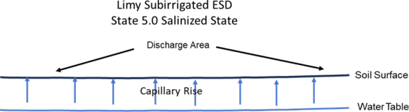
Figure 8.
Table 4. Representative soil features
| Parent material |
(1)
Glaciolacustrine deposits
(2) Till (3) Glaciofluvial deposits (4) Eolian deposits (5) Lacustrine deposits |
|---|---|
| Surface texture |
(1) Loam (2) Silt loam (3) Silty clay loam (4) Fine sandy loam (5) Loamy fine sand (6) Coarse sandy loam |
| Family particle size |
(1) Loamy (2) Sandy |
| Drainage class | Somewhat poorly drained |
| Permeability class | Moderately slow to moderately rapid |
| Soil depth | 80 in |
| Surface fragment cover <=3" | 8% |
| Surface fragment cover >3" | 2% |
| Available water capacity (0-40in) |
3 – 9 in |
| Calcium carbonate equivalent (0-40in) |
5 – 45% |
| Electrical conductivity (0-16in) |
8 mmhos/cm |
| Sodium adsorption ratio (0-16in) |
5 |
| Soil reaction (1:1 water) (0-40in) |
6.6 – 8.4 |
| Subsurface fragment volume <=3" (Depth not specified) |
35% |
| Subsurface fragment volume >3" (Depth not specified) |
5% |
Ecological dynamics
This ecological site description is based on nonequilibrium ecology and resilience theory and utilizes a State- and-Transition Model (STM) diagram to organize and communicate information about ecosystem change as a basis for management. The ecological dynamics characterized by the STM diagram reflect how changes in ecological drivers, feedback mechanisms, and controlling variables can maintain or induce changes in plant community composition (phases and/or states). The application of various management actions, combined with weather variables, impact the ecological processes which influence the competitive interactions, thereby maintaining or altering plant community structure.
Prior to European influence, the historical disturbance regime for MLRA 55B included frequent fires, both anthropogenic and natural in origin. Most fires, however, were anthropogenic fires set by Native Americans. Native Americans set fires in all months except perhaps January. These fires occurred in two peak periods, one from March-May with the peak in April and another from July-November with the peak occurring in October. Most of these fires were scattered and of small extent and duration. The grazing history would have involved grazing and browsing by large herbivores (such as American bison, elk, and whitetail deer). Herbivory by small mammals, insects, nematodes, and other invertebrates are also important factors influencing the production and composition of the communities. Grazing and fire interaction, particularly when coupled with drought events, influenced the dynamics discussed and displayed in the following state and transition diagram and descriptions.
Following European influence, this ecological site generally has had a history of grazing by domestic livestock, particularly cattle, which along with other related activities (e.g., fencing, water development, fire suppression) has changed the disturbance regime of the site. Changes will occur in the plant communities due to these and other factors.
Weather fluctuations coupled with managerial factors may lead to changes in the plant communities and may, under adverse impacts, result in a slow decline in vegetative vigor and composition. However, under favorable conditions the botanical composition may resemble that prior to European influence.
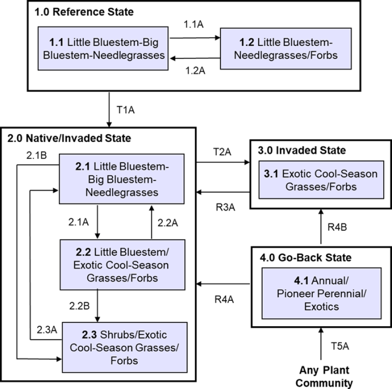
Four vegetative states have been identified for the site (Reference, Native/Invaded, Invaded, and Go-Back). Within each state, one or more community phases have been identified. These community phases are named based on the more dominant and visually conspicuous species; they have been determined by study of historical documents, relict areas, scientific studies, and ecological aspects of plant species and plant communities. Transitional pathways and thresholds have been determined through similar methods.
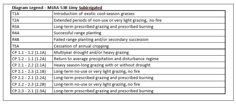
State 1: Reference State represents the natural range of variability that dominated the dynamics of this ecological site prior to European influence. Dynamics of the state were largely determined by variations in climate and weather (e.g., drought), as well as that of fire (e.g., timing, frequency) and grazing by native herbivores (e.g., frequency, intensity, selectivity). Due to those variations, the Reference State is thought to have shifted temporally and spatially between two plant community phases.
Currently the primary disturbances include widespread introduction of exotic species, concentrated livestock grazing, lack of fire, and perhaps long-term non-use and no fire. Because of these changes, particularly the widespread occurrence of exotic species, as well as other environmental changes, the Reference State is considered to no longer exist. Thus, the presence of exotic species on the site precludes it from being placed in the Reference State. It must then be placed in one of the other states, commonly State 2: Native/Invaded State (T1A).
State 2: Native/Invaded State. Colonization of the site by exotic species results in a transition from State 1: Reference State to State 2: Native/Invaded State (T1A). This transition was inevitable; it often resulted from colonization by exotic cool-season grasses (commonly Kentucky bluegrass, smooth brome, and/or quackgrass) which have been particularly and consistently invasive under extended periods of non-use and no fire. Other exotic plants (e.g., Canada thistle, leafy spurge) are also known to invade the site.
Three community phases have been identified for this state; they are similar to the community phases in the Reference State but have now been invaded by exotic cool-season grasses. These exotic cool-season grasses can be expected to increase. As that increase occurs, plants more desirable to wildlife and livestock may decline. A decline in forb diversity can also be expected. Under non-use or minimal use management, mulch increases and may become a physical barrier to plant growth. This also changes the micro-climate near the soil surface and may alter infiltration, nutrient cycling, and biological activity near the soil surface. As a result, these factors coupled with shading cause desirable native plants to have increasing difficulty remaining viable and recruitment declines.
To slow or limit the invasion of these exotic cool-season grasses or other exotic plants, it is imperative that managerial options (e.g., prescribed grazing, prescribed burning) be carefully constructed and evaluated with respect to that objective. If management does not include measures to control or reduce these exotic plants, the transition to State 3: Invaded State should be expected (T2A).
State 3: Invaded State. The threshold for this state is reached when both the exotic cool-season grasses (e.g., Kentucky bluegrass, smooth brome, quackgrass) exceed 30% of the plant community and native grasses represent less than 40% of the community. One community phase has been identified for this state.
The exotic cool-season grasses can be quite invasive and often form monotypic stands. As they increase, both forage quantity and quality of the annual production becomes increasingly restricted to late spring and early summer, even though annual production may increase. Forb diversity often declines. Under non-use or minimal use management, mulch can increase and become a physical barrier to plant growth which alters nutrient cycling, infiltration, and soil biological activity. As such, desirable native plants become increasingly displaced.
Once the state is well established, prescribed burning and prescribed grazing techniques have been largely ineffective in suppressing or eliminating the exotic cool-season grasses, even though some short-term reductions may appear successful. However, assuming there is an adequate component of native grasses to respond to treatments, a restoration pathway to State 2: Native/Invaded State may be accomplished with the implementation of long-term prescribed grazing in conjunction with prescribed burning (R3A).
State 4: Go-Back State often results following cropland abandonment and consists of only one plant community phase. This weedy assemblage may include noxious weeds that need control. Over time, the exotic cool-season grasses (e.g., Kentucky bluegrass, smooth brome, quackgrass) will likely predominate.
Initially, due to extensive bare ground and a preponderance of shallow rooted annual plants the potential for soil erosion is high. Plant species richness may be high, but overall diversity (i.e., equitability) is typically low, with the site dominated by a relatively small assemblage of species. Due to the lack of native perennials and other factors, restoring the site with the associated ecological processes is difficult. However, a successful range planting may result in something approaching State 2: Native/Invaded State (R4A). Following establishment, prescribed grazing, prescribed burning, haying, and the use of herbicides will generally be necessary to achieve the desired result and control weeds, some of which may be noxious weeds. A failed range planting and/or secondary succession will lead to State 3: Invaded State (R4B).
State 5.0: Salinized State often results from long-term overgrazing or annual haying on high-water table soils. This leads to an increase in lower statured shallow-rooted plants, decreased litter, increased bare ground, resulting in decreased transpiration and increased evaporation resulting in increased upward water movement to the soil surface through capillary rise. Water evaporates and soluble salts accumulate. Salinity greater than 8 dS/m favors foxtail barley, salt grass, and bare ground. The site remains somewhat poorly drained.
Increased salinity is the main driver for the transition to State 5.0 Salinized State of a Limy Subirrigated ecological site. Increased salinity levels favor salt tolerant vegetation and will make perennial vegetation establishment more difficult. State 5.0: Salinized State also occurs along the upland boundary of wetlands. Long term overgrazing or total removal of vegetation (cropping) along the wetland edge increases evaporation with less transpiration; this brings salts to the soil surface increasing surface salinity. This salinization process can be exasperated by cropping the recharge areas around the wetland.
Woody Invasion. Historically, individual (or small patches of) shrubs and/or trees were scattered across the site. However, a marked increase in fire suppression, climate change, increase in non-use, and other factors enabled woody species to colonize, form patches (resistant to fire), and begin to or encroach on the site. These changes have enabled these patches to expand and become more widespread. Encroachment of both native and exotic woody species (e.g., Rocky Mountain juniper, Russian olive, Siberian elm, western snowberry, silverberry, ponderosa pine, eastern red cedar, etc.) are examples of woody vegetation increasing in extent and impinging on the ecological integrity of the grassland biome. Windbreaks and other tree plantings can contain problematic and invasive species (such as eastern redcedar, Rocky Mountain juniper, ponderosa pine, Russian olive, etc.) which can contaminate surrounding grasslands. This results in increased long-term costs to maintain or restore this ecological site to native grasses and forbs.
The following state and transition model diagram illustrates the common states, community phases, community pathways, and transition and restoration pathways that can occur on the site. These are the most common plant community phases and states based on current knowledge and experience; changes may be made as more data are collected. Pathway narratives describing the site’s ecological dynamics reference various management practices (e.g., prescribed grazing, prescribed fire, brush management, herbaceous weed treatment) which, if properly designed and implemented, will positively influence plant community competitive interactions. The design of these management practices will be site specific and should be developed by knowledgeable individuals; based upon management goals and a resource inventory; and supported by an ongoing monitoring protocol.
When the management goal is to maintain an existing plant community phase or restore to another phase within the same state, modification of existing management to ensure native species have the competitive advantage may be required. To restore a previous state, the application of two or more management practices in an ongoing manner will be required. Whether using prescribed grazing, prescribed burning, or a combination of both with or without additional practices (e.g., brush management), the timing and method of application needs to favor the native species over the exotic species. Adjustments to account for variations in annual growing conditions and implementing an ongoing monitoring protocol to track changes and adjust management inputs to ensure desired outcome will be necessary.
The plant community phase composition table(s) has been developed from the best available knowledge including research, historical records, clipping studies, and inventory records. As more data are collected, plant community species composition and production information may be revised.
State and transition model
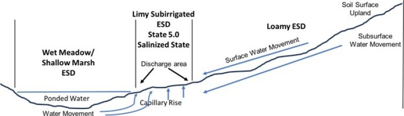
Figure 9. Depicts water movement (surface and subsurface) from Wet Meadow/ Shallow Marsh and adjacent upland site to the State 5.0 Salinized State of a this ecological site. Increased salinity levels will make establishment of grasses and forbs more difficult.
More interactive model formats are also available.
View Interactive Models
More interactive model formats are also available.
View Interactive Models
Click on state and transition labels to scroll to the respective text
State 2 submodel, plant communities
State 3 submodel, plant communities
State 4 submodel, plant communities
State 1
Reference State
This state represents the natural range of variability that dominated the dynamics of this ecological site prior to European influence. The primary disturbance mechanisms for this site in the reference condition included frequent fire and grazing by large herding ungulates. Timing of fires and grazing, coupled with weather events, dictated the dynamics that occurred within the natural range of variability. These factors likely caused the community to shift both spatially and temporally between two community phases.
Characteristics and indicators. (i.e., characteristics and indicators that can be used to distinguish this state from others). Because of changes in disturbances and other environmental factors (particularly the widespread occurrence of exotic species), the Reference State is considered to no longer exist.
Resilience management. (i.e., management strategies that will sustain a state and prevent a transition). If intact, the reference state should probably be managed with current disturbance regimes which has permitted the site to remain in reference condition as well as maintaining the quality and integrity of associated ecological sites. Maintenance of the reference condition is contingent upon a monitoring protocol to guide management.
Community 1.1
Little Bluestem-Big Bluestem-Needlegrasses (Schizachyrium scoparium-Andropogon gerardii-Hesperostipa spp., Nassella viridula)
This community phase was historically the most dominant both temporally and spatially and was dominated by tall and mid warm-season grasses. The major warm-season grasses included little bluestem, big bluestem, switchgrass, and Indiangrass. Major cool-season graminoids were porcupinegrass, green needlegrass, wheatgrasses, and sedges. Sunflowers, goldenrods, white heath aster, common yarrow, and white sagebrush were among the more common forbs. Prairie rose and western snowberry common shrubs. Annual production likely varied from about 2800-4400 pounds per acre with grasses and grass-likes, forbs, and shrubs contributing about 85%, 10% and 5%, respectively. Both warm-season and cool-season grasses are represented in the community; as a result, production was distributed throughout the growing season. This community represents the plant community phase upon which interpretations are primarily based and is described in the “Plant Community Composition and Group Annual Production” portion of this ecological site description.
Figure 10. Annual production by plant type (representative values) or group (midpoint values)
Table 5. Annual production by plant type
| Plant type | Low (lb/acre) |
Representative value (lb/acre) |
High (lb/acre) |
|---|---|---|---|
| Grass/Grasslike | 2555 | 3204 | 3840 |
| Forb | 175 | 270 | 375 |
| Shrub/Vine | 70 | 126 | 185 |
| Total | 2800 | 3600 | 4400 |
Figure 11. Plant community growth curve (percent production by month). ND5310, Missouri Coteau, lowland warm-season dominant.. Warm-season dominant, lowland..
| Jan | Feb | Mar | Apr | May | Jun | Jul | Aug | Sep | Oct | Nov | Dec |
|---|---|---|---|---|---|---|---|---|---|---|---|
| J | F | M | A | M | J | J | A | S | O | N | D |
| 0 | 0 | 0 | 1 | 28 | 31 | 25 | 10 | 3 | 2 | 0 | 0 |
Community 1.2
Little Bluestem-Needlegrasses/Forbs/ (Schizachyrium scoparium- Hesperostipa spp., Nassella viridula/Forbs)
This community phase formed during multiyear drought and/or heavy grazing. This resulted in a marked decrease in little bluestem and an increase in forbs. Annual production decreased compared to that of Community Phase 1.1.
Pathway 1.1A
Community 1.1 to 1.2
Community Phase Pathway 1.1 to 1.2 occurred with multiyear drought with or without heavy grazing. This led to a marked decrease in big bluestem along with an increase in forbs.
Pathway 1.2A
Community 1.2 to 1.1
Community Phase Pathway 1.2 to 1.1 occurred with the return to average precipitation and disturbance regime, leading to an increase in big bluestem along with a decrease in forbs.
State 2
Native/Invaded State
This state is similar to State 1: Reference State but has now been colonized by the exotic cool-season grasses (e.g., Kentucky bluegrass, smooth brome, quackgrass) which are now present in small amounts. Although the state is still dominated by native grasses, an increase in these exotic cool-season grasses can be expected. These exotic cool-season grasses can be quite invasive on the site and are particularly well adapted to heavy grazing. They also often form monotypic stands. As these exotic cool-season grasses increase, both forage quantity and quality become increasingly restricted to late spring and early summer due to the monotypic nature of the stand, even though annual production may increase. Native forbs generally decrease in production, abundance, diversity, and richness compared to that of State 1: Reference State. These exotic cool-season grasses have been particularly and consistently invasive under extended periods of no use and no fire. To slow or limit the invasion of these exotic grasses, it is imperative that managerial options (e.g., prescribed grazing, prescribed burning) be carefully constructed and evaluated with respect to that objective. If management does not include measures to control or reduce these exotic cool-season grasses, the transition to State 3: Invaded State should be expected. Annual production of this state can be quite variable, in large part due to the amount of exotic cool-season grasses. However, as the exotic cool-season grasses increase, peak production will shift to earlier in the growing season.
Characteristics and indicators. (i.e., characteristics and indicators that can be used to distinguish this state from others). The presence of trace amounts of exotic cool-season grasses indicates a transition from State 1 to State 2. The presence of exotic biennial or perennial leguminous forbs (i.e., sweet clover, black medic) may not, on their own, indicate a transition from State 1 to State 2 but may facilitate that transition.
Resilience management. (i.e., management strategies that will sustain a state and prevent a transition). To slow or limit the invasion of these exotic grasses, it is imperative that managerial options (e.g., prescribed grazing, prescribed burning) be carefully constructed and evaluated with respect to that objective. Grazing management should be applied that enhances the competitive advantage of native grass and forb species. This may include: (1) grazing when exotic cool-season grasses are actively growing and native cool- season grasses are dormant; (2) applying proper deferment periods allowing native grasses to recover and maintain or improve vigor; (3) adjusting overall grazing intensity to reduce excessive plant litter (above that needed for rangeland health indicator #14 – see Rangeland Health Reference Worksheet); (4) incorporating early heavy spring utilization which focuses grazing pressure on exotic cool-season grasses and reduces plant litter, provided that livestock are moved when grazing selection shifts from exotic cool-season grasses to native grasses. Prescribed burning should be applied in a manner that maintains or enhances the competitive advantage of native grass and forb species. Prescribed burns should be applied as needed to adequately reduce/remove excessive plant litter and maintain the competitive advantage for native species. Timing of prescribed burns (spring vs. summer vs. fall) should be adjusted to account for differences in annual growing conditions and applied during windows of opportunity to best shift the competitive advantage to the native species.
Community 2.1
Little Bluestem-Big Bluestem-Needlegrasses (Schizachyrium scoparium-Andropogon gerardii-Hesperostipa spp., Nasella viridula)
This community phase closely resembles Community Phase 1.1 but the exotic cool-season grasses (e.g., Kentucky bluegrass, smooth brome, quackgrass) have become minor components of the community. This community phase is dominated by tall and mid warm-season grasses and mid cool-season grasses, such as little bluestem and big bluestem, along with porcupinegrass and green needlegrass. Other graminoids include switchgrass, Indiangrass, sideoats grama, western wheatgrass, slender wheatgrass and sedges. A variety of native perennial forbs are generally present in small amounts and may include American licorice, white heath aster, stiff goldenrod, stiff sunflower, Maximillian sunflower, and Canadian anemone. This warm-season grass dominated community may be maintained with prescribed grazing systems that allow for adequate recovery periods following grazing events and, perhaps, a combination of prescribed grazing and prescribed burning which closely mimics the natural disturbance regime. Continued invasion by the exotic cool-season grasses may lead to the transition to the State 3: Invaded State.
Community 2.2
Little Bluestem/Exotic Cool-Season Grasses/Forbs (Schizachyrium scoparium/Exotic Cool-Season Grasses/Forbs)
This community phase occurs with heavy season-long grazing with or without drought, leading to a reduction of the tall, less grazing tolerant species, such as big bluestem, and corresponding increases in the shorter more grazing tolerant species and the exotic cool-season grasses. Exotic grasses (such as Kentucky bluegrass, smooth bromes, and/or quackgrass) increase markedly. In the early stages of this community phase, little bluestem initially increases but with inadequate recovery periods it eventually decreases. As such, peak production shifts to earlier in the growing season due to the increase in exotic cool-season grasses. Major graminoids of this community phase include little bluestem, green needlegrass, western wheatgrass, slender wheatgrass, Kentucky bluegrass and sedges. Other grasses present include big bluestem, switchgrass, porcupinegrass, and sideoats grama. Common forbs include American licorice, white sagebrush, goldenrod, silverleaf Indian breadroot, and common yarrow. Western snowberry and prairie rose are the principal shrubs. This community phase is often dispersed throughout a pasture in an overgrazed/ undergrazed pattern, typically referred to as patch grazing. Some overgrazed areas will exhibit the impacts of heavy use, while the ungrazed areas will have a build-up of litter and increased plant decadence. This is a typical pattern found in properly stocked pastures grazed season-long. As a result, Kentucky bluegrass tends to increase more in the undergrazed areas while the more grazing tolerant short-statured species, such as blue grama and sedges, increase in the heavily grazed areas. If present, Kentucky bluegrass may increase under heavy grazing. This community phase is approaching the threshold leading to a transition to State 3: Invaded State. As a result, it is an “at risk” community. If management does not include measures to control or reduce these exotic cool-season grasses, the transition to State 3: Invaded State should be expected. However, implementation of long-term prescribed grazing and/or prescribed burning may move the community back to Community Phase 2.1 Little Bluestem-Big Bluestem-Needlegrass.
Community 2.3
Shrubs/Exotic Cool-Season Grasses/Forbs
This community phase is dominated by shrubs (such as western snowberry, prairie rose, white meadowsweet, and willows), alone or in combination. The exotic cool-season grasses have increased markedly with a corresponding decrease in the native grasses. Forbs often include goldenrods, silverweed cinquefoil, scouring rush, common yarrow, Flodman’s thistle, and others.
Pathway 2.1A
Community 2.1 to 2.2
Community Phase Pathway 2.1 to 2.2 often occurs with heavy season-long grazing with or without drought. Along this pathway, the timing of peak production will shift to earlier in the growing season due to the increase in exotic cool-season grasses. Also along this pathway is a decrease in the production and diversity of native plants.
Pathway 2.1B
Community 2.1 to 2.3
Community Phase Pathway 2.1 to 2.3 often occurs with long-term non-use or very light grazing, and no fire. This results in marked increases in the exotic cool-season grasses and corresponding decreases in native grasses, particularly warm-season species.
Pathway 2.2A
Community 2.2 to 2.1
Community Phase Pathway 2.2 to 2.1 occurs with the implementation of long-term prescribed grazing and prescribed burning which includes adequate recovery periods following each grazing event and stocking levels which match the available resources. If properly implemented, this will shift the competitive advantage from the introduced cool-season grasses to the tall and mid warm-season grasses, such as big bluestem and little bluestem. The implementation of prescribed burning may expedite this shift as opposed to only prescribed grazing.
Pathway 2.2B
Community 2.2 to 2.3
Community Phase Pathway 2.2 to 2.3 occurs with long-term no-use or very light grazing, and no fire which results in increases in shrubs, exotic cool-season grasses, and forbs along with a corresponding decrease in the native grasses.
Pathway 2.3A
Community 2.3 to 2.1
Community Phase Pathway 2.3 to 2.1. occurs with the implementation of long-term prescribed grazing and prescribed burning to reduce the exotic cool-season grasses and shrubs and stimulate the native grasses. Because many shrubs sprout following one burn, repeated treatments are generally necessary.
State 3
Invaded State
This state is the result of invasion and dominance by the exotic cool-season grasses (e.g., Kentucky bluegrass, smooth brome, quackgrass). Other exotic plants (e.g., leafy spurge) may also invade the site. These exotic cool-season grasses can be quite invasive on the site and are particularly well adapted to heavy grazing. They also often form monotypic stands. As these exotic cool-season grasses increase, both forage quantity and quality become increasingly restricted to late spring and early summer due to the monotypic nature of the stand, even though annual production may increase. Native forbs generally decrease in production, abundance, diversity, and richness compared to that of State 1: Reference State. Common forbs often include white heath aster, goldenrod, common yarrow, and white sagebrush. Shrubs, such as western snowberry and rose, may show marked increases. Once the state is well established, prescribed burning and grazing techniques have been largely ineffective in suppressing or eliminating these species, even though some short- term reductions may appear successful. Annual production of this state may vary widely, in part due to variations in the extent of invasion by exotic cool-season grasses. However, as the exotic cool-season grasses increase, annual production will shift to earlier in the growing season.
Characteristics and indicators. (i.e., characteristics that can be used to distinguish this state from others). This site is characterized by exotic cool-season grasses constituting greater than 30 percent of the annual production and native grasses constituting less than 40 percent of the annual production.
Resilience management. (i.e., management strategies that will sustain a state and prevent a transition). Light or moderately stocked continuous, season-long grazing or a prescribed grazing system which incorporates adequate deferment periods between grazing events and proper stocking rate levels will maintain this State. Application of herbaceous weed treatment, occasional prescribed burning and/or brush management may be needed to manage noxious weeds and increasing shrub (e.g., western snowberry) populations.
Community 3.1
Exotic Cool-Season Grasses/Forbs
This community phase is typically dominated by the exotic cool-season grasses (e.g., Kentucky bluegrass, quackgrass, smooth brome). Native warm-season and cool-season grasses may be present but are much reduced compared to that of the reference state. The center area of bunchgrasses, such as little bluestem, may become decadent and die due to complete lack of grazing and burning. Forbs common to this community phase include American licorice, white heath aster, Canada goldenrod, Flodman’s thistle, white heath aster, black-eyed Susan, and Norwegian cinquefoil. Western snowberry and other shrubs may also be a noticeable component in this community phase. The longer this community phase exists, the more resilient it becomes. Natural or management disturbances that reduce the cover of Kentucky bluegrass or smooth brome are typically short-lived. In some situations, the peak production may become restricted to a short period during early spring due to the abundance of Kentucky bluegrass or the other exotic cool-season grasses. Forb production varies considerably but may contribute nearly one-fourth of the total production.
State 4
Go-Back State
This state is highly variable depending on the level and duration of disturbance related to the T5A transitional pathway. In this MLRA, the most probable origin of this state is plant succession following cropland abandonment. This plant community will initially include a variety of annual forbs and grasses, some of which may be noxious weeds and need control. Over time, the exotic cool-season grasses (Kentucky bluegrass, smooth brome, and/or quackgrass) will likely predominate.
Characteristics and indicators. (i.e., characteristics and indicators that can be used to distinguish this state from others). Tillage has destroyed the native plant community, altered soil structure and biology, reduced soil organic matter, and resulted in the formation of a tillage induced compacted layer which is restrictive to root growth. Removal of perennial grasses and forbs results in decreased infiltration and increased runoff.
Resilience management. (i.e., management strategies that will sustain a state and prevent a transition). Continued tillage will maintain the state. Control of noxious weeds will be required.
Community 4.1
Annual/Pioneer Perennial /Exotics
This community phase is highly variable depending on the level and duration of disturbance related to the T5A transitional pathway. In this MLRA, the most probable origin of this phase is secondary succession following cropland abandonment. This plant community will initially include a variety of annual forbs and grasses, including noxious weeds (e.g., Canada thistle) which may need control. Over time, the exotic cool-season grasses (Kentucky bluegrass, smooth brome, and/or quackgrass) will likely predominate.
State 5
Any Plant Community
Transition T1A
State 1 to 2
This is the transition from the State 1: Reference State to the State 2: Native/Invaded State due to the introduction and establishment of exotic cool-season grasses (e.g., Kentucky bluegrass, smooth brome, quackgrass). This transition was inevitable and corresponded to a decline in native warm-season and cool- season grasses; it may have been exacerbated by chronic season-long or heavy late season grazing. Complete rest from grazing and suppression of fire could also have hastened the transition. The threshold between states was crossed when Kentucky bluegrass, smooth brome, quackgrass, or other exotic species became established on the site.
Constraints to recovery. (i.e., variables or processes that preclude recovery of the former state). Current knowledge and technology will not facilitate a successful restoration to Reference State.
Transition T2A
State 2 to 3
This is the transition from the State 2: Native/Invaded State to State 3: Invaded State; it can occur under extended periods of non-use or very light grazing, and/or no fire. Increasing plant litter under no grazing and no fire leads to an increase in the shade tolerant exotic cool-season grasses, particularly Kentucky bluegrass. Similarly, heavy grazing also benefits the grazing tolerant exotic species, such as Kentucky bluegrass and/or quackgrass. Preliminary studies indicate this threshold may occur when both Kentucky bluegrass exceeds 30% of the plant community and native grasses represent less than 40% of the plant community composition. Similar thresholds may exist for the other exotic cool-season grasses. Once the threshold is crossed, grazing management alone cannot reduce the exotic cool-season grasses; prescribed burning is difficult and largely ineffective in reducing the exotic cool-season grasses due to early green-up and high moisture/humidity conditions. Burning is also difficult under heavy season-long grazing, due to low fuel loads.
Constraints to recovery. (i.e., variables or processes that preclude recovery of the former state). Variations in growing conditions (e.g., cool, wet spring) will influence effects of various management activities on exotic cool-season grass populations.
Restoration pathway R3A
State 3 to 2
This restoration pathway from State 3: Invaded State to State 2: Native/Invaded State may be accomplished with the implementation of long-term prescribed grazing and prescribed burning, assuming there is an adequate component of native grasses to respond to the treatments. Both prescribed grazing and prescribed burning are likely necessary to successfully initiate this restoration pathway, the success of which depends upon the presence of a remnant population of native grasses in Community Phase 3.1. That remnant population, however, may not be readily apparent without close inspection. The application of several prescribed burns may be needed at relatively short intervals in the early phases of this restoration process, in part because many of the shrubs (e.g., western snowberry) sprout following one burn. Early season prescribed burns have been successful; however, fall burning may also be an effective technique. The prescribed grazing should include adequate recovery periods following each grazing event and stocking levels which match the available resources. If properly implemented, this will shift the competitive advantage from the exotic cool-season grasses to the native cool-season grasses.
Context dependence. (i.e., factors that cause variations in plant community shifts, restoration likelihood, and contribute to uncertainty). Grazing management should be applied in a manner that enhances/maximizes the competitive advantage of native grass and forb species over the exotic species. This may include the use of prescribed grazing to reduce excessive plant litter accumulations above that needed for rangeland health indicator #14 (see Rangeland Health Reference Worksheet). Increasing livestock densities may facilitate the reduction in plant litter provided length and timing of grazing periods are adjusted to favor native species. Grazing prescriptions designed to address exotic grass invasion and favor native species may involve earlier, short, intense grazing periods with proper deferment to improve native species health and vigor. Fall (e.g., September, October) prescribed burning followed by an intensive, early spring graze period with adequate deferment for native grass recovery may shift the competitive advantage to the native species, facilitating the restoration to State 2: Native/Invaded. Prescribed burning should be applied in a manner that enhances the competitive advantage of native grass and forb species over the exotic species. Prescribed burns should be applied at a frequency which mimics the natural disturbance regime, or more frequently as is ecologically (e.g., available fuel load) and economically feasible. Burn prescriptions may need adjustment to: (1) account for change in fine fuel orientation (e.g., “flopped” Kentucky bluegrass); (2) fire intensity and duration by adjusting ignition pattern (e.g., backing fires vs head fires); (3) account for plant phenological stages to maximize stress on exotic species while favoring native species (both cool- and warm-season grasses).
Restoration pathway R4A
State 4 to 2
This Restoration Pathway from State 4: Go-Back State to the State 2: Native/Invaded State can be accomplished with a successful range planting. Following establishment, prescribed grazing, prescribed burning, haying, or use of herbicides will generally be necessary to achieve the desired result and control any noxious weeds. It may be possible using selected plant materials and agronomic practices to approach something very near the functioning of State 2: Native/Invaded State. Application of chemical herbicides and the use of mechanical planting methods using adapted varieties of the dominant native grasses are possible and can be successful. After establishment of the native plant species, prescribed grazing should include adequate recovery periods following each grazing event and stocking levels which match the available resources; management objectives must include the maintenance of those species, the associated reference state functions, and continued treatment of exotic grasses.
Context dependence. (i.e., factors that cause variations in plant community shifts, restoration likelihood, and contribute to uncertainty). A successful range planting will include proper seedbed preparation, weed control (both prior to and after the planting), selection of adapted native species representing functional/structural groups inherent to the State 1, and proper planting technique. Management (e.g., prescribed grazing, prescribed burning) during and after establishment must be applied in a manner that maintains the competitive advantage for the seeded native species. Adding non-native species can impact the above and below ground biota. Elevated soil nitrogen levels have been shown to benefit smooth brome and Kentucky bluegrass more than some native grasses. As a result, fertilization, exotic legumes in the seed mix, and other techniques that increase soil nitrogen may promote smooth brome and Kentucky bluegrass invasion. The method or methods of herbaceous weed treatment will be site specific to each situation; but generally, the goal would be to apply the pesticide, mechanical control, or biological control (either singularly or in combination) in a manner that shifts the competitive advantage from the targeted species to the native grasses and forbs. The control method(s) should be as specific to the targeted species as possible to minimize impacts to non-target species.
Restoration pathway R4B
State 4 to 3
A failed range planting and/or secondary succession will lead to State 3: Invaded State.
Context dependence. (i.e., factors that cause variations in plant community shifts, restoration likelihood, and contribute to uncertainty). Failed range plantings can result from many causes (both singularly and in combination) including drought, poor seedbed preparation, improper planting methods, seeded species not adapted to the site, insufficient weed control, herbicide carryover, poor seed quality (purity & germination), and/or improper management.
Restoration pathway T5A
State 5 to 4
This is the transition from any plant community to State 4: Go-Back State. It is most commonly associated with the cessation of cropping without the benefit of range planting, resulting in a “go-back” situation. Soil conditions can be quite variable on the site, in part due to variations in the management/cropping history (e.g., development of a tillage induced compacted layer (plow pan), erosion, fertility, and/or herbicide/pesticide carryover). Thus, soil conditions should be assessed when considering restoration techniques.
Additional community tables
Table 6. Community 1.1 plant community composition
| Group | Common name | Symbol | Scientific name | Annual production (lb/acre) | Foliar cover (%) | |
|---|---|---|---|---|---|---|
|
Grass/Grasslike
|
||||||
| 1 | Tall & Mid Warm-Season | 1440–2160 | ||||
| little bluestem | SCSC | Schizachyrium scoparium | 900–1260 | – | ||
| big bluestem | ANGE | Andropogon gerardii | 360–720 | – | ||
| sideoats grama | BOCU | Bouteloua curtipendula | 72–360 | – | ||
| switchgrass | PAVI2 | Panicum virgatum | 0–180 | – | ||
| Indiangrass | SONU2 | Sorghastrum nutans | 0–180 | – | ||
| 2 | Mid Cool-Season | 180–900 | ||||
| porcupinegrass | HESP11 | Hesperostipa spartea | 72–360 | – | ||
| green needlegrass | NAVI4 | Nassella viridula | 72–360 | – | ||
| western wheatgrass | PASM | Pascopyrum smithii | 72–360 | – | ||
| 3 | Other Native Grasses | 108–180 | ||||
| blue grama | BOGR2 | Bouteloua gracilis | 36–180 | – | ||
| slender wheatgrass | ELTR7 | Elymus trachycaulus | 36–180 | – | ||
| fowl bluegrass | POPA2 | Poa palustris | 36–72 | – | ||
| Canada wildrye | ELCA4 | Elymus canadensis | 36–72 | – | ||
| Grass, perennial | 2GP | Grass, perennial | 0–72 | – | ||
| 4 | Grass-Likes | 180–360 | ||||
| sedge | CAREX | Carex | 180–360 | – | ||
| Grass-like (not a true grass) | 2GL | Grass-like (not a true grass) | 36–144 | – | ||
| mountain rush | JUARL | Juncus arcticus ssp. littoralis | 36–72 | – | ||
|
Forb
|
||||||
| 6 | Forbs | 180–360 | ||||
| Forb, perennial | 2FP | Forb, perennial | 0–108 | – | ||
| common yarrow | ACMI2 | Achillea millefolium | 0–72 | – | ||
| dogbane | APOCY | Apocynum | 36–72 | – | ||
| aster | ASTER | Aster | 36–72 | – | ||
| American licorice | GLLE3 | Glycyrrhiza lepidota | 36–72 | – | ||
| Maximilian sunflower | HEMA2 | Helianthus maximiliani | 36–72 | – | ||
| stiff sunflower | HEPA19 | Helianthus pauciflorus | 36–72 | – | ||
| goldenrod | SOLID | Solidago | 36–72 | – | ||
| wood lily | LIPH | Lilium philadelphicum | 0–36 | – | ||
| mint | MENTH | Mentha | 0–36 | – | ||
| cinquefoil | POTEN | Potentilla | 0–36 | – | ||
| Flodman's thistle | CIFL | Cirsium flodmanii | 0–36 | – | ||
| northern bedstraw | GABO2 | Galium boreale | 0–36 | – | ||
| anemone | ANEMO | Anemone | 0–36 | – | ||
|
Shrub/Vine
|
||||||
| 7 | Shrubs | 72–180 | ||||
| western snowberry | SYOC | Symphoricarpos occidentalis | 36–108 | – | ||
| Shrub (>.5m) | 2SHRUB | Shrub (>.5m) | 0–72 | – | ||
| redosier dogwood | COSE16 | Cornus sericea | 36–72 | – | ||
| chokecherry | PRVI | Prunus virginiana | 0–72 | – | ||
Interpretations
Animal community
Animal Community – Wildlife Interpretations
Landscape
The MLRA 53B landscape is characterized by nearly level to rolling till plains including kettle holes, kames, moraines, and small glacial lakes. The MLRA is located within the heart of the Prairie Pothole (Coteau) Region with temporary, seasonal, and semi-permanent wetlands throughout the MLRA. MLRA 53B has a continental climate with cold winters and hot summers, low humidity, light rainfall, and much sunshine. Extremes in temperature are common and characteristic of the MLRA. This area supports natural prairie vegetation characterized by western wheatgrass, needle and thread, green needlegrass, and big bluestem. Little bluestem is an important species on sloping and shallow soils. Prairie cordgrass, northern reedgrass, and sedges are important species on wet soils. Western snowberry, chokecherry, plum, stiff goldenrod, blacksamson echinacea, and prairie rose are commonly interspersed throughout the area.
Complex and intermingled ecological sites create diverse grass and shrub land habitats. Ecological sites are interspersed with moderate to high densities of depressional wetlands. MLRA 53B includes headwaters to tributaries of the Missouri River, including the Big Muddy River, White Earth River, Painted Woods Creek and Apple Creek in North Dakota and Spring Creek in South Dakota. Numerous unnamed creeks and drainageways drain into the James River in North and South Dakota which are in MLRA 55B. These habitats provide critical life-cycle components for many wildlife species including aquatic species.
Historic Communities/Conditions within MLRA 53B:
The northern mixed-grass prairie was a disturbance-driven ecosystem with fire, herbivory, and climate functioning as the primary ecological drivers, either singly or often in combination. The high density of wetland and associated native grassland historically supported an abundance of waterfowl and other marsh dependent birds. Many species of grassland birds, small mammals, insects, reptiles, amphibians, and herds of roaming American bison, elk, and pronghorn were historically among the inhabitants adapted to this semi-arid region. Roaming herbivores, as well as several small mammal and insect species, were the primary consumers linking the grassland resources to large predators (such as the wolf and mountain lion) and smaller carnivores (such as the coyote, bobcat, red fox, and raptors). Extirpated species include free-ranging American bison, elk, black and grizzly bear, gray wolf, and peregrine falcon (breeding). Extinct from the region is the Rocky Mountain locust.
Present Communities/Conditions within MLRA 53B:
Following European influence, domestic livestock grazing, elimination of fire, energy development, and other anthropogenic factors influenced plant community composition and abundance. Approximately 34% of the native grassland in MLRA 53B remains intact but grassland continues to be converted to annual cropping systems. Annual cropping, wetland drainage, wind energy, woody encroachment, and transportation corridors are the main contributors to habitat fragmentation, which reduces habitat quality for area-sensitive species. The fragmented landscape reduced or eliminated ecological drivers (fire) and introduced exotic plant species including smooth brome, crested wheatgrass, Kentucky bluegrass, and leafy spurge - further impacting plant and animal communities. Loss of fire allowed woody species to expand onto historically grassland sites. The loss of these ecological drivers greatly influenced the remaining native plant communities and wildlife species presence, moving towards a more fragmented but diverse landscape; but in many cases a more homogeneous grassland dominated by cool-season exotic grass species develops.
The high density of wetlands provides habitat for large numbers and species of waterfowl and waterbirds. MLRA 53B is a major contributor to the annual production of waterfowl and waterbirds within the Central Flyway. Many wildlife species found in MLRA 53B are those that have adapted to annual crop production. Some wildlife species in this area are white-tailed deer, coyote, red fox, American badger, raccoon, beaver, striped skunk, American mink, white-tailed jackrabbit, Eastern turkey, sharp-tailed grouse, waterfowl, and numerous species of grassland-nesting birds and pollinating insects. Numerous fish species inhabit the lakes and creeks within the MLRA.
National wildlife refuges, waterfowl production areas, and state wildlife management areas along with North Dakota Department of Trust Lands and South Dakota State School Lands provide herbaceous and woody cover for wildlife. In addition, the United States Army Corps of Engineers, United States Fish and Wildlife Service (USFWS), and the North Dakota Game and Fish Department (NDGFD) jointly manage one large manmade reservoir, Lake Audubon (16,612 acres), for waterfowl and fish production. The USFWS manages approximately 56,000 acres in National Wildlife Refuges and 59,000 acres of Waterfowl Production Areas including 5,526 acres of wilderness area within the Lostwood National Wildlife Refuge and 4,201 acres of wilderness area within the Chase Lake National Wildlife Refuge. The NDGFD manages approximately 47,000 acres of Wildlife Management Areas (WMA) and the South Dakota Game Fish and Parks manages approximately 12,000 acres of Game Production Areas in the southern end of the MLRA.
Wildlife species presence is often determined by site characteristics including grass and forb species, hydrology, aspect, and other associated ecological sites. Home ranges of most species are larger than one ecological site or are dependent upon more than one ecological site for annual life requisites. Ecological sites offer different habitat elements as the annual life requisites change. Habitat improvement and creation must be conducted within the mobility limits of a known population for the species.
Insects play an important role providing ecological services for plant community development. Insects that are scavengers or aid in decomposition provide the food chain baseline sustaining the carnivorous insects feeding upon them. Many insects provide the ecological services necessary for pollination, keeping plant communities healthy and productive. Insects provide a protein food source for numerous species including grassland-nesting birds and their young.
Species of Concern within MLRA 53B:
The following is a list of species considered “species of conservation priority” in the North Dakota State Wildlife Action Plan (2015) and South Dakota State Wildlife Action Plan (2014); and species listed as “threatened, endangered, or petitioned” under the Endangered Species Act within MLRA 53B at the time this section was developed:
Invertebrates: Dakota skipper, Dakota stonefly, Iowa skipper, monarch butterfly, northern sandy tiger beetle, Ottoe skipper, regal fritillary, yellow-banded bumble bee, and western bumble bee.
Birds: American avocet, American bittern, American kestrel, American white pelican, Baird’s sparrow, bald eagle, black-billed cuckoo, black tern, bobolink, burrowing owl, canvasback, chestnut-collared longspur, Dickcissel, ferruginous hawk, Franklin’s gull, grasshopper sparrow, greater prairie-chicken, horned grebe, horned lark, lark bunting, LeConte’s sparrow, lesser scaup, loggerhead shrike, long-billed curlew, marbled godwit, Nelson’s sparrow, northern goshawk, northern harrier, northern pintail, peregrine falcon (migration), piping plover (migration), red knot (migration), sharp-tailed grouse, short-eared owl, Sprague’s pipet, Swainson’s hawk, trumpeter swan, upland sandpiper, western meadowlark, willet, Wilson’s phalarope, whooping crane (migration), and yellow rail.
Mammals: Arctic shrew, big and little brown bats, Franklin’s ground squirrel, plains pocket mouse, Richardson’s ground squirrel, silver-haired bat, and swift fox (historical range).
Amphibians and Reptiles: Canadian toad, false map turtle, plains hognose snake, smooth green snake, and snapping turtle.
Fish and Mussels: Blacknose shiner, blue sucker, burbot, fathead chub, fragile papershell, northern pearl dace, northern redbelly dace, pink papershell, sicklefin chub, sturgeon chub, and yellow sandshell.
Grassland Management for Wildlife in the MLRA 53B
Management activities within State and Transition models follow various community phase pathways. These management activities will impact wildlife, both positive and negative, but are essential for maintenance of healthy grassland ecosystems. Community phase, transitional, and restoration pathways are keys to long-term management within each State and between States. Timing, intensity, and frequency of these inputs can have dramatic positive or negative effects on local wildlife species. Ranchers and other land managers must always consider the long-term beneficial management effects of grassland and woodland resources in comparison to typically short-term negative effects to the habitats of individual species.
Ecological sites occur as intermingled complexes on the landscape with gradual or sometimes abrupt transitions. Rarely do ecological sites exist in large enough acreage to manage independently for wildlife. A management regime for one ecological site may negatively impact an adjacent site (e.g., alteration of a grazing regime within a Loamy Overflow ecological site to encourage tall warm-season grass development) may encourage exotic cool-season grasses to increase or dominate adjacent ecological sites.
Life requisites and habitat deficiencies are determined for targeted species, species guilds, or by land use. Deficiencies need to be addressed along community phase, transitional, and restoration pathways as presented in specific state-and-transition models. Ecological sites should be managed and restored within the site’s capabilities to provide sustainable habitat for targeted species or species guilds. Habitat fragmentation caused by the conversion to annual cropping, tree plantings, rural housing, and fragmentation due to transportation and electrical transmission corridors need to be considered when managing for target species.
With populations of many grassland-nesting birds in decline, it is important to maintain these ecological sites in a 1.0 Reference State (if found) or the 2.0 Native/Invaded State. Plant communities optimal for a guild of grassland species serve as a population source where the birth rate exceeds mortality. Species may use marginal plant communities; however, these sites may function as a population sink where mortality exceeds the birth rate.
Understanding preferred vegetative stature and sensitivity to woody encroachment is necessary to manage for the specific grassland species. Various grass heights may be used for breeding, nesting, or foraging habitat. While most species use varying heights, many have a preferred vegetative stature height. The following chart provides preferred vegetative stature heights and sensitivity to woody vegetation encroachment.
To see the chart please follow the hyperlink.
https://efotg.sc.egov.usda.gov/references/public/ND/53B_Limy_Subirrigated_Narrative_FINAL_Ref_FSG.pdf
Limy Subirrigated Wildlife Habitat Interpretation:
Limy Subirrigated ecological sites are somewhat poorly drained. They are usually found on flats, slight rises, and slightly convex slopes adjacent to shallow depressions on till plains, lake plains, outwash plains, and sand plains; they also occur on some low terraces of drainageways and on lake shores. This site has a persistent water table strongly influencing vegetation production. These soils typically are calcareous in the surface layer and have a highly calcareous upper subsoil; they are dominated by tall and mid warm-season grasses and forbs. Little bluestem and big bluestem are the dominant mid and tall warm-season grasses. Associated ecological sites include Clayey, Saline Lowland, Loamy, Subirrigated, Wet Meadow, and Shallow Marsh.
Limy Subirrigated habitat features and components commonly support many edge-sensitive grassland bird species preferring medium- to tall-statured vegetation. Insects rely on associated forbs and grasses for survival. High insect populations provide food sources for birds and their young. Limy Subirrigated ecological sites provide quality forage for small and large herbivores. Dakota skippers use Limy Subirrigated ecological sites in MLRA 53B.
Limy Subirrigated ecological sites may be found in four plant community states (1.0 Reference State, 2.0 Native/Invaded State, 3.0 Invaded State, and 4.0 Go-Back State). Multiple plant community phases exist within State 2.0. These states occur primarily in response to grazing, drought, and non- use. Secondary influences include fire and anthropogenic disturbances.
Because there is no known restoration pathway from State 2.0 to State 1.0, it is important to intensively manage using tools in State 1.0 and State 2.0 community phase pathways to prevent further plant community degradation along Transitional Pathway T1A to Invaded Grass State 2.0.
As plant communities degrade within State 2.0, warm-season grasses, particularly short-statured and cool-season exotic grasses, increase while native forbs are reduced. This transition results in reduced structure, increased plant community homogeneity, and reduced insect populations resulting in a reduction of breeding, nesting, foraging, or winter habitat for grassland birds. When adjacent/intermingled ecological sites undergo the same transition, the result can be an expansive, homogenous landscape. Success along restoration pathway R3A and R4A to State 2.0 is very difficult and is dependent upon presence of remnant native grass populations or a successful native range planting.
Management along community phase, transition, or restoration pathways should focus upon attainable changes. Short- and long-term monetary costs must be evaluated against short- and long- term ecological services in creating and maintaining habitat of enough quality to support a sustainable population.
1.0 Reference State
Community Phase 1.1 Little Bluestem-Big Bluestem-Needlegrasses: This plant communities offers quality vegetative cover for wildlife; every effort should be made to maintain this ecological site within this community phase. This phase retains high functionality through continued maintenance including prescribed grazing with adequate recovery period as well as prescribed fire. Prescribed fire frequency maintains a grass-dominated plant community providing habitat for bird species sensitive to woody vegetation. Predominance of grass species in these communities favors grazers and mixed feeders (animals selecting grasses as well as forbs and shrubs). The structural diversity provides habitat for a wide array of migratory and resident birds.
Invertebrates: Insects play a role in maintaining the forb community and provide a forage base for grassland birds, reptiles, and rodents. Ecological services, historically provided by bison, are simulated by domestic livestock. These services include putting plant material and dung in contact with mineral soil to be used by lower trophic level consumers (such as invertebrate decomposers, scavengers, shredders, predators, herbivores, dung beetles, and fungal feeders).
Dakota skippers prefer this site due to host plants, such as little and big bluestem and harebell. Regal fritillary can make use of violet species and other nectar producing forbs on these sites. Monarch butterfly may use flowering forbs; however, few milkweed species are found on these sites to support caterpillar food. Bumblebees and other native bees utilize forbs as a nectar source; bare ground and nesting sites are available due to the dominance of bunch grasses. Prescribed grazing with adequate recovery periods, as well as prescribed fire to maintain the 1.1 phase, will have long term positive effects on ground dwelling insects.
Birds: This plant community provides quality nesting, foraging, and escape habitats favored by mid- to tallgrass-nesting birds. Prescribed fire maintains a grass-dominated plant community providing habitat for bird species sensitive to woody vegetation and limits litter accumulations. This plant community does not provide suitable areas for sharp-tailed grouse lek sites, but do provide quality nesting, brood-rearing, and escape habitat. This site provides good hunting opportunities for grassland raptors.
Mammals: The diversity of grasses and forbs provide high nutrition levels for small and large herbivores including voles, mice, jackrabbits, and white-tailed deer. Tall- to mid-statured vegetation provides suitable food and thermal, protective, and escape cover for small and large herbivores.
Amphibians and Reptiles: This ecological site can provide habitat for the northern leopard frog and Canadian toad since this site is frequently found adjacent to Wet Meadow and Shallow Marsh ecological sites. It also provides habitat for the northern prairie skink and plains hog-nosed snake.
Fish and Mussels: This ecological site can be located adjacent to streams, rivers, or water bodies. These sites receive run-on hydrology from adjacent ecological sites and provide hydrology to Wet Meadow or Shallow Marsh ecological sites. Management on Limy Subirrigated sites, in conjunction with neighboring run-on sites, will have a direct effect on aquatic species in streams and/or tributaries receiving water from Limy Subirrigated and adjacent sites. Optimum hydrological function and nutrient cycling limit potential for sediment yield and nutrient loading to the adjacent aquatic ecosystems from Community Phase 1.1.
Community Phase 1.2 Little Bluestem-Needlegrasses/Forbs: The reduction/loss of big bluestem shifts this plant community from tall warm-season to a medium warm-season plant community. A return to normal precipitation and normal disturbance regime, via Community Phase 1.2A, can move this plant community back to a one dominated by tall warm-season grasses.
Invertebrates: Provides similar life requisites as Community Phase 1.1; however, an increase in forbs provides a forage base for grassland birds, reptiles, and rodents.
Birds: A reduction in tall warm-season grasses with an increase in mid-statured grasses and forbs provides opportunities for grassland nesting birds preferring medium structure.
Mammals: Provides similar life requisites as Community Phase 1.1 with a reduction of cover for large mammals.
Amphibians and Reptiles: Provides similar life requisites as Community Phase 1.1.
Fish and Mussels: Provides similar life requisites as Community Phase 1.1.
2.0 Native/Invaded State
Community Phase 2.1 Little Bluestem-Big Bluestem-Needlegrasses: Plant structure within Plant Community Phase 2.1 is very similar to 1.1 except for the invasion of minor amounts of cool-season exotic grasses, mainly Kentucky bluegrass.
Invertebrates: Provides similar life requisites as Community Phase 1.1. Birds: Provides similar life requisites as Community Phase 1.1.
Mammals: Provides similar life requisites as Community Phase 1.1.
Amphibians and Reptiles: Provides similar life requisites as Community Phase 1.1.
Fish and Mussels: Provides similar life requisites as Community Phase 1.1.
Community Phase 2.2 Little Bluestem-Exotic Cool-Season Grasses/Forbs: Heavy season-long grazing without adequate recovery periods or non-use along Community Phase Pathway 2.1A reduces tall, warm-season grasses while shorter, more grazing tolerant species increase. The reduction of vigor of warm-season grasses allows for the increase in exotic cool-season grasses (such as Kentucky bluegrass, smooth brome, or quackgrass). This community phase is often found in a mosaic in the pasture in an over-grazed/under-grazed pattern typical of properly stocked pastures grazed season long. Some areas will be impacted by heavy use while other areas will have a build-up of litter and a high amount of plant decadence. This mosaic of grazed and ungrazed areas provides a short to tall vegetative stature. Dependent upon the patch size of over-grazed vs. under- grazed, grassland nesting birds preferring short/mid-vegetative stature may prefer this plant community phase. Implementation of a prescribed grazing and prescribed burning system, via Community Phase Pathway 2.2A, will help shift the plant community back to 2.I.
Invertebrates: Provides similar life requisites as Community Phase 1.1 dependent upon degree of exotic grass invasion. Invertebrates will respond to the amount of over-utilized vs. under-utilized area and the resultant vegetative stature. Reduced litter amounts on the over-utilized area will have an increase in bare ground will favor ground nesting insects; under-utilized areas will have a decrease in bare ground for ground-nesting insects but may have more pollen and nectar producing forbs.
Birds: Dependent upon the amount of over-utilized vs. under-utilized area, vegetative stature could favor short- to tall-grass bird species.
Mammals: Overall shorter stature vegetation reduces thermal, escape, and loafing cover.
Amphibians and Reptiles: Provides similar life requisites as Community Phase 1.1.
Fish and Mussels: Provides similar life requisites as Community Phase 1.1.
Community Phase 2.3 Shrubs/Exotic Cool-Season Grasses/Forbs: Extended periods of non-use or light use, and no fire (via 2.1B or 2.2B) allow shrubs (such as western snowberry, chokecherry, and redosier dogwood) to dominate this site. Shade tolerant Kentucky bluegrass dominates the understory. This plant community is “at risk” to transition to State 3: Invaded State. Warm-season, native grasses may still be present but with reduced vigor and numbers not allowing for recovery without prescribed grazing and burning via Community Phase Pathway 2.3A.
Invertebrates: The invasion of woody vegetation reduces or eliminates habitat for all species of concern within MLRA 53B. Season-long pollen and nectar availability becomes limited on this site. Western snowberry and other shrubs will provide some early- to mid-season bloom period. Forbs (such as goldenrods, silverweed cinquefoil, and Flodman’s thistle) will provide limited pollen and nectar opportunities. Overall, pollinator plant diversity is low which limits season-long nectar and pollen production.
Birds: As low-statured western snowberry and other taller shrubs become dominant on this site, grassland-nesting birds sensitive to woody vegetation encroachment will be negatively impacted and discontinue use of this community phase. Bird species favoring shrub dominated communities will increase; but birds preferring woodland edge will have limited use since only low statured woody vegetation is available.
Mammals: Shrubs will provide increased year-round, low statured cover and browse for white-tailed deer and high litter amounts provide food, thermal, protective, and escape cover for small herbivores, moose, and elk.
Amphibians and Reptiles: This site no longer provides life requisites for the northern prairie skink and plains hog-nosed snake due to the dominance of shrubs.
Fish and Mussels: Provides similar life requisites as Community Phase 1.1.
3.0 Invaded State
Community Phase 3.1 Exotic Cool-Season Grasses/Forbs: Community Phase Pathway T2A is characterized by complete non-use or no grazing, light grazing, or heavy season-long grazing when exotic cool-season grasses are present as in Community Phase 2.0. Increase in plant litter under no use and/or no fire increase shade tolerant Kentucky bluegrass. Heavy grazing also favors grazing tolerant Kentucky bluegrass. This plant community phase is characterized by a dominance (>30%) of exotic cool-season grasses, such as smooth brome; native grasses represent less than 40% of the plant community. Restoration Pathway R3A, through prescribed burning and high levels of grazing management, requires remnant amounts of native warm- and cool-season and forbs to be successful. The remnant native community needs frequent prescribed burns and high levels of grazing management targeting the exotic cool-season grasses to improve competitiveness and increase vigor and density. Without intensive management, the remnant native plants will not increase adequately to transition back to State 2.0. Managers need to evaluate impacts to wildlife while implementing these management practices. Intensified management along the R3A Pathway will have significant short-term negative impacts on wildlife habitat; however, this is necessary to restore long-term native habitat functions.
Invertebrates: Exotic grasses limit use by beneficial insects found in States 1.0 and 2.0. However, when western snowberry is a major component; it provides early- to mid- season pollen and nectar sources. Although forbs are a minor component in this community, they still offer mid- to late-season pollen and nectar opportunities. Increased litter and lack of grazing leads to limited contact between plant material and mineral soil resulting in a cooler micro-climate, which is unfavorable to most insects. Lack of bare soil limits ground-nesting sites for native bees and other ground-nesting insects.
Birds: The homogeneous community phase, dominated by exotic plant species, provides limited habitat and life requisites for most obligate grassland-nesting birds. Lack of plant diversity and stature, along with increased litter and the tendency of Kentucky bluegrass and smooth brome to lay down, limits use by many grassland-nesting birds. Sharp-tailed grouse may use this plant community for lek sites and nesting cover; western snowberry may provide winter cover, dependent upon density.
Mammals: Litter accumulation and exotic grass cover favors thermal, protective, and escape cover for small rodents.
Amphibians and Reptiles: Provides similar life requisites as Community Phase 2.3.
Fish and Mussels: Provides similar life requisites as Community Phase 1.1.
4.0 Go-Back State
Community Phase 4.1 Annual/Pioneer Perennial/Exotics: Following cropland abandonment, these plant communities are dominated by early pioneer annual and perennial plant species. Plant species composition and production are highly variable. Weedy plants can provide pollinator habitat along with spring and summer cover for many mammals and birds, and their young. Dense weed cover can keep soils moist, increasing insect presence. Tall stature provided by some weeds, such as marsh elder and ragweed, offer thermal cover and seeds throughout winter for deer, small mammals, and over-wintering birds. The response by wildlife species will be dependent upon plant community composition, vegetative stature, patch size, and management activities (such as prescribed grazing, burning, inter-seeding, haying, or noxious weed control).
Successful restoration of native species along Transition Pathway R4A can result in a native grass and forb community in State 2.0. Over time, with no management, the exotic cool-season perennial grasses (Kentucky bluegrass, smooth brome, and/or quackgrass) generally become established and dominate the community. Failed native grass planting, via Transition Pathway R4B, can result in an invaded plant community Invaded State 3.0.
Animal Community – Grazing Interpretations
This site is well adapted to managed grazing by domestic livestock. The predominance of herbaceous plants across all plant community phases best lends these sites to grazing by cattle, but other domestic grazers with differing diet preferences may also be a consideration depending upon management objectives. Often, the current plant community does not entirely match any particular plant community (as described in the ecological site description). Because of this, a resource inventory is necessary to document plant composition and production. Proper interpretation of this inventory data will permit the establishment of a safe, initial stocking rate for the type and class of animals and level of grazing management. More accurate stocking rate estimates should eventually be calculated using actual stocking rate information and monitoring data.
NRCS defines prescribed grazing as “managing the harvest of vegetation with grazing and/or browsing animals with the intent to achieve specific ecological, economic, and management objectives”. As used in this site description, the term ‘prescribed grazing’ is intended to include multiple grazing management systems (e.g., rotational grazing, twice-over grazing, conservation grazing, targeted grazing, etc.) provided that, whatever management system is implemented, it meets the intent of prescribed grazing definition.
The basic grazing prescription addresses balancing forage demand (quality and quantity) with available forage, varying grazing and deferment periods from year-to-year, matching recovery/deferment periods to growing conditions when pastures are grazed more than once in a growing season, implementation of a contingency (e.g., drought) plan, and a monitoring plan. When the management goal is to facilitate change from one plant community phase or state to another, then the prescription needs to be designed to shift the competitive advantage to favor the native grass and forb species.
Grazing levels are noted within the plant community narratives and pathways in reference to grazing management. “Degree of utilization” is defined as the proportion of the current years forage production that is consumed and/or destroyed by grazing animals (may refer to a single plant species or a portion or all the vegetation). “Grazing utilization” is classified as slight, moderate, full, close, and severe (see the following table for description of each grazing use category). The following utilization levels are also described in the Ranchers Guide to Grassland Management IV. Utilization levels are determined by using the landscape appearance method as outlined in the Interagency Technical Reference “Utilization Studies and Residual Measurements” 1734-3.
Utilization Level % Use Description
Slight (Light) 0-20 Appears practically undisturbed when viewed obliquely. Only choice areas and forage utilized.
Moderate 20-40 Almost all of accessable range shows grazing. Little or no use of poor forage. Little evidence of trailing to grazing.
Full 40-60 All fully accessable areas are grazed. The major sites have key forage species properly utilized (about half taken, half left). Points of concentration with overuse limited to 5 to 10 percent of accessible area.
Close (Heavy) 60-80 All accessible range plainly shows use and major sections closely cropped. Livestock forced to use less desirable forage, considering seasonal preference.
Severe > 80 Key forage species completely used. Low-value forages are dominant.
Hydrological functions
The duration of the seasonal high-water table within the rooting zone is the principal factor limiting herbage production on this site. The site is dominated by soils in hydrologic groups B and C with a few areas in group A. Infiltration varies from moderately slow to moderately rapid and runoff potential varies from negligible to low for this site depending on hydrologic group, surface texture, slope percent, slope shape, and ground cover. In many cases, areas with greater than 75% ground cover have the greatest potential for high infiltration and lower runoff. An exception would be where shortgrasses form a dense sod and dominate the site. Areas where ground cover is less than 50% have the greatest potential to have reduced infiltration and higher runoff (refer to Section 4, NRCS National Engineering Handbook for runoff quantities and hydrologic curves).
Hydrological manipulation (surface or tile drainage, pumping, surface water diversion, etc.) modifies this ecological site. Under natural conditions, this ecological site includes a wide range of soil textures; after hydrologic manipulation, soil texture often becomes a more significant factor in vegetative response. If the degree of manipulation allows soil texture to influence the plant community or if altered soil properties (i.e., salinization or the addition of fill material) results in vegetation change, a transition to a completely different ecological site may have occurred. The transition to an altogether different ecological site will depend upon severity of altered hydrology, soil properties, and corresponding vegetation. Due to the many variables (e.g., hydrology, type and success of drainage, etc.), impacts to the ecological site will be site-specific. As a result, each situation will require field investigation to determine what, if any, changes in ecological site designation is necessary and proceed accordingly.
Without restoring hydrologic function (which may include range planting), managers need to reference state and transition models within those sites. Hydrology will need to be fully restored in the associated Wet Meadow and Shallow Marsh ecological sites in for these sites to properly function. It is recommended that managers review the appropriate State and Transition Models prior to wetland restoration
Recreational uses
National wildlife refuges (NWR) (56,476 acres), waterfowl production areas (WPAs) (183,465 acres), state wildlife management areas (WMAs) (59,476 acres), Department of Trust Lands/State School Lands (284,695 acres), and the United State Army Corps of Engineers (65,619 acres) provide hunting, bird watching, hiking, and other outdoor recreation opportunities. Audubon WMA, North Dakota, is the largest state managed, wildlife area covering 6,716 acres. The largest refuges managed by the United States Fish and Wildlife service are Audubon NWR (14,735 acres); Lostwood NWR (26,747 acres with 5,526 acres designated as wilderness area); Chase Lake NWR (4,385 acres, of which 4,201 acres were designated a wilderness area); and Long Lake NWR (22,300 acres). United States Bureau of Reclamation manages approximately 2,215 acres for fish and wildlife habitat. The Bureau of Land Management manages 6,042 acres in small, scattered tracts across the MLRA.
Bird watching: Prairie-dependent and migratory birds provide quality birding opportunities within this MLRA. NWRs, WPAs, and WMAs provide essential habitat for prairie-dependent bird species (such as Sprague's pipit and Baird's sparrow) along with some of the larger, showy members of the upland prairie including marbled godwit, upland sandpipes, and willet. MLRA 53B is in the heart of spring and fall bird migratory routes.
Chase Lake NWR is home to one of the largest breeding colonies of American white pelicans and has been identified by the American Bird Conservancy as one of the top 100 Globally Important Bird Areas in the United States. Lostwood NWR is designated a Globally Important Bird Area by the American Birding Conservancy and the Audubon Society. Long Lake NWR consists of a 15,000-acre saline basin that is 18 miles long and is appropriately named "Long Lake". The refuge was listed as a top 10 birding site by Wild Bird Magazine. It was also recently designated as both a Globally Important Bird Area and a Western Hemisphere Shorebird Reserve Network (WHSRN) site because of its importance as both a breeding and migratory stopover site for more than 20,000 shorebirds, annually.
Hunting/Fishing: MLRA 53B is a fall destination for thousands of waterfowl hunters. The density of prairie pothole wetlands, WPAs, state owned trust lands, and WMAs provide quality opportunities for waterfowl and upland game bird hunting. This MLRA also provides quality white-tailed deer hunting opportunities along with moose hunting opportunities.
Quality fishing (summer and winter fishing) opportunities are available in the MLRA. The North Dakota Game and Fish Department and the South Dakota Game Fish and Parks manages approximately 125 fishing lakes within the MLRA. Available species include yellow perch, walleye, northern pike, muskellunge, crappie, bluegill, and small mouth bass. Lake Audubon is the largest fishing lake within the MLRA. A portion of Lake Audubon, within the National Wildlife refuge system, provides ice fishing access only; there is no open-water fishing on the refuge portion of Lake Audubon.
Camping: The Bureau of Reclamation manages the Brekken-Holmes Recreation Area in the Turtle Lake area. The recreation area consists of approximately 675 water surface acres, 620 land acres, and 10 miles of shoreline. The Garrison Conservancy District provides primitive camping along the chain of lakes connected by the McClusky Canal diverting water eastward into central North Dakota. Nine state parks are located within the MLRA totaling 1,340 acres. Fort Stevenson State Park is the only State Park in the MLRA that provides boating access to Lake Sakakawea. Other numerous camping (primitive and improved) sites are available in numerous city and county parks.
Hiking: The North Country Trail dissects the MLRA east to west following the 76-mile section of the McClusky Canal; in addition is has 12 miles of off-road trails through the Audubon National Wildlife Refuge, a road walk from Coleharbor to Riverdale and across Garrison Dam, and a short, off-road segment leading to the Western Terminus within Lake Sakakawea State Park. Hiking is also permitted on other state and federally owned lands. In addition, the Lostwood NWR and the Audubon NWR have 7 and 8 miles, respectively, of self-guided auto tours.
Wood products
There are no appreciable wood products on this site.
Other products
Seed harvest of native plant species can provide additional income on this site.
Other information
Site Development and Testing Plan
• North Dakota and South Dakota have had overlapping ecological site concepts for calcareous soils with risk of salinization. North Dakota had separated moderately saline phases of Aeric Calciaquolls from their non-saline to slightly saline phases. Components with E.C. >8 had been assigned to the Saline Lowland ecological site. Components with E.C. <8 dS/m were assigned to Limy Subirrigated. In South Dakota, components with an E.C. <4 dS/m were assigned to Limy Subirrigated and those with E.C. >4 dS/m were assigned to Saline Subirrigated (an ecological site that has not been recognized in North Dakota). Some investigation and considerable discussion have taken place attempting to resolve these differing concepts.
A primary issue has been the similarity of plant communities in the Reference State between Limy Subirrigated and Saline Subirrigated and the observation that salinity is spatially highly variable within a soil map unit. Saline Subirrigated allows an E.C. range as high as 16 dS/m. Big Bluestem and Indiangrass are particularly sensitive to salinity; production is likely significantly reduced at E.C. of 4 to 8 dS/m and most plants will die at E.C. >8 dS/m. It is believed that this likely constitutes a threshold; a pathway back to a less salt-affected state may not exist or is at least impractical from a management standpoint.
Questions have been raised as to soil survey mapping criteria – if ecological site (or range site) was the principle interpretive focus of soils assigned to Saline Subirrigation or if cropland and the impacts of salinity on salt-sensitive annual crops was the primary interpretive focus. This question has not yet been answered.
As a way to move forward and harmonize ESDs until further investigations can be conducted, a Saline State has been added to the STM for Limy Subirrigated with an enhanced narrative concerning salinization risk and related management strategies. The Saline Subirrigated ESD will not be used in MLRAs for which ND has responsibility until further investigations are completed and consistent soil/plant community criteria can be developed.
• Further investigation of areas of this site is recommended where it occurs on lake shores. These areas are periodically inundated for extended periods. When many of the soil surveys were completed, these soils were not inundated; currently many of them are inundated and have been for many consecutive years. The major component in this site affected by recent inundation is Mauvais. The MLRA map units needing investigation is:
Wamduska-Mauvais complex, 0 to 9 percent slopes (map unit 2q83b)
• Components of the Mauvais soil series need to be re-linked to the Limy Subirrigated ES in NASIS; they are currently linked to the Subirrigated ES.
• Further investigation is needed on the wide range of soil textures and associated properties and their relationship to hydrology/plant dynamics.
• Further investigation in need on areas of this site associated with drainageways. Moritz soils occur along the outer edges of some channeled drainageways. The impact of occasional flooding on these areas needs evaluation.
• Further evaluation and refinement of the State-and-Transition model may be needed to identify disturbance driven dynamics. Additional states and/or phases may be required to address grazing response.
• Further documentation may be needed for plant communities in all states. Plant data has been collected in previous range-site investigations, including clipping data; however, this data needs review. If geo-referenced sites meeting Tier 3 standards for either vegetative or soil data are not available, representative sites will be selected for further investigation.
• Site concepts will be refined as the above noted investigations are completed.
• The long-term goal is to complete an approved, correlated Ecological Site Description as defined by the National Ecological Site Handbook.
• NASIS revisions needed:
o During the recently completed Ecological Site Description update, saline phases of Aeric Calciaquolls were reassigned from Saline Lowland to the Salinized State of Limy Subirrigated. Numerous components of Divide, Fram, and Hamerly need to be relinked.
o During the recently completed Ecological Site Description update, Mauvais soil was reassigned from Subirrigated to Limy Subirrigated; all Mauvais components need to be relinked.
This ESD is the best available knowledge. The site concept and species composition table have been used in the field and tested for more than five years. It is expected that as additional information becomes available revisions may be required.
Supporting information
Inventory data references
Information presented here has been derived from NRCS and other federal/state agency clipping and inventory data. Also, field knowledge of range-trained personnel was used. All descriptions were peer reviewed and/or field-tested by various private, state, and federal agency specialists.
Other references
Bakker, K.K. 2003. The effect of woody vegetation on grassland nesting birds: an annotated bibliography. The Proceedings of the South Dakota Academy of Science 82:119-141.
Barker, W.T. and W. C. Whitman. 1988. Vegetation of the Northern Great Plains. Rangelands 10(6): 266-272. Bluemle. J.P. 2016. North Dakota’s geologic legacy. North Dakota State University Press. 382 pages.
Briske, D.D. (editor). 2017. Rangeland systems – processes, management, and challenges. Springer Series on Environmental Management. 661 pages.
Burgess, R.L. 1965. A study of plant succession in the sandhills of southeastern North Dakota. Proceedings ND Academy of Science 19:62-80
DeKeyser, E.S., G. Clambey, K. Krabbenhoft, and J. Ostendorf. 2009. Are changes in species composition on central North Dakota rangelands due to non-use management? Rangelands 31:16-19
Dix, R.L. and F.E. Smeins. 1967. The prairie, meadow, and marsh vegetation of Nelson County, North Dakota. Canadian Journal of Botany 45:21-57.
Dornbusch, M.J., R.F. Limb, and C.K. Gasch. 2018. Facilitation of an exotic grass through nitrogen enrichment by an exotic legume. Rangeland Ecology & Management 71:691-694.
Dyke, S.R., S.K. Johnson, and P.T. Isakson. 2015. North Dakota state wildlife action plan. North Dakota Game and Fish Department, Bismarck, ND. 468 pages.
Ehrenfeld, Joan G. 2002. Effects of exotic plant invasions on soil nutrient cycling processes. Ecosystems 6:503-523.
Ereth, C., J. Hendrickson, D. Kirby, E. DeKeyser, K. Sedevic, and M. West. Controlling Kentucky bluegrass with herbicide and burning is influenced by invasion level. Invasive Plant Science and Management 10: 80-89.
Ewing, J. 1924. Plant succession on the brush prairie in northwestern Minnesota. Journal of Ecology 12:228- 266.
Gilgert, W. and S. Zack. 2010. Integrating multiple ecosystem services into ecological site descriptions. Rangelands: 32:49-54.
Grant, T.A. and R.K. Murphy. 2005. Changes on woodland cover on prairie refuges in North Dakota, USA. Natural Areas Journal 25:359-368.
Heitschmidt, R. K., K. D. Klement, and M. R. Haferkamp. 2005. Interactive effects of drought and grazing on northern great plains rangelands. Rangeland Ecology and Management 58:11-19.
Hendrickson, J.R., P. S. Johnson, M. A. Liebig, K. K. Sedivec, and G. A. Halvorson. 2016. Use of ecological sites in managing wildlife and livestock: an example with prairie dogs. Rangelands
Hendrickson, J.R., S.L. Kronberg, and E.J. Scholljegerdes. 2020. Can targeted grazing reduce abundance of invasive perennial grass (Kentucky Bluegrass) on native mixed-grass prairie? Rangeland Ecology and Management, 73:547-551.
Higgins, K.F. 1984. Lightning fires in grasslands in North Dakota and in pine-savanna lands in nearby South Dakota and Montana. J. Range Manage. 37:100-103.
Higgins, K.F. 1986. Interpretation and compendium of historical fire accounts in the Northern Great Plains. United States Department of Interior, Fish and Wildlife Service. Resource Publication 161. 39 pages.
Higgins, K.F., A.D. Kruse, and J.L. Piehl. 1989. Effects of fire in the Northern Great Plains. U.S. Fish and Wildlife Service and Cooperative Extension Service South, Dakota State University. Extension Circular 761. 48 pages.
High Plains Regional Climate Center, University of Nebraska, 830728 Chase Hall, Lincoln, NE 68583-0728. (http://hprcc.unl.edu)
Johnson, Sandra. 2015. Reptiles and amphibians of North Dakota. North Dakota Game and Fish Department. 64 pages.
Jordan, N. R., D.L. Larson, and S.C. Huerd. 2008. Soil modification by invasive plants: effects on native and invasive species of mixed-grass prairies. Biological Invasions 10:177-190.
Lura, C.L., W.T. Barker, and P.E. Nyren.1988. Range plant communities of the Central Grasslands Research Station in south central North Dakota. Prairie Naturalist 20:177-192.
Mader, E., M. Shepherd, M. Vaughan, and S.H. Black. 2011. Attracting native pollinators: protecting North America's bees and butterflies. Accessed at https://xerces.org, May 1, 2017.
North Dakota Division of Tourism, Accessed on February 25, 2019. Available at https://www.ndtourism.com/sports-recreation
North Dakota Parks and Recreation Department, Accessed on February 25, 2019. Available at http://www.parkrec.nd.gov/recreationareas/recreationareas.html
Palit, R., G. and E.S. DeKeyser. 2022. Impacts and drivers of smooth brome (Bromus inermis Leyes.) invasion in native ecosystems. Plants: 10,3390. http://https://www.mdpi.com/2223-7747/11/10/1340
Palit, R., G. Gramig, and E.S. DeKeyser. 2021. Kentucky bluegrass invasion in the Northern Great Plains and prospective management approaches to mitigate its spread. Plants: 10,817. https://doi.org/10.3390/plants10040817
Printz, J.L. and J.R. Hendrickson. 2015. Impacts of Kentucky bluegrass Invasion (Poa pratensis) on ecological processes in the Northern Great Plains. Rangelands 37(6):226-232.
Redmann, Robert E. 1975. Production ecology of grassland plant communities in western North Dakota. Ecological Monographs 45:83-106.
Reeves, J.L., J.D. Derner, M.A. Sanderson, J.R. Hendrickson, S.L. Kronberg, M.K. Petersen, and L.T. Vermeire. 2014. Seasonal weather influences on yearling beef steer production in C3-dominated Northern Great Plains rangeland. Agriculture, Ecosystems and Environment 183:110-117.
Royer, R. A., 2003. Butterflies of North Dakota: an atlas and guide. Minot State University, Minot, ND.
Seabloom, R. 2020. Mammals of North Dakota. North Dakota Institute for Regional Studies, Fargo, ND. 470 pages.
Sedivec, K.D., J.L. Printz. 2014. Ranchers guide to grassland management IV. NDSU Extension Service publication R1707.
Severson, K. E. and C. Hull Sieg. 2006. The nature of eastern North Dakota: pre-1880 historical ecology. North Dakota Institute for Regional Studies.
South Dakota Dept. of Game, Fish and Parks. 2014. South Dakota Wildlife Action Plan. Wildlife Division Report 2014-03.
Spaeth, K.E., Hayek, M.A., Toledo, D., and Hendrickson, J. 2019. Cool season grass impacts on native mixedgrass prairie species in the Norther Great Plains. America’s Grassland Conference: Working Across Boundaries. The Fifth Biennial Conference on the Conservation of America’s Grasslands. Bismarck, ND. 20-22 August.
Tidwell, D., D.T. Fogarty, and J.R. Weir. 2021. Woody encroachment in grasslands, a guide for understanding risk and vulnerability. Oklahoma State University, Oklahoma Cooperative Extension Service publication E- 1054. 32 pages.
Toledo, D., M. Sanderson, K. Spaeth, J. Hendrickson, and J. Printz. 2014. Extent of Kentucky bluegrass and its effect on native plant species diversity and ecosystem services in the northern great plains of the United State. Invasive Plant Science and Management 7(4): 543-552.
USDA, NRCS. 2021. National range and pasture handbook, (https://www.nrcs.usda.gov/wps/portal/nrcs/detailfull/national/landuse/rangepasture/?cid=stelprdb1043084)
USDA, NRCS. 2006. Land resource regions and major land resource areas of the United States, the Caribbean, and the Pacific Basin. U.S. Department of Agriculture Handbook 296.
USDA, NRCS. National Soil Information System, 100 Centennial Mall North, Room 152, Lincoln, NE 68508- 3866.(https://www.nrcs.usda.gov/wps/portal/nrcs/detail/soils/survey/tools/?cid=nrcs142p2_053552)
USDA, NRCS. National Water & Climate Center, 1201 NE Lloyd Blvd, Suite 802, Portland, OR 97232-1274. (https://www.wcc.nrcs.usda.gov/)
USDA, NRCS. 2001. The PLANTS database, Version 3.1 (http://plants.usda.gov). National Plant Data Center, Baton Rouge, LA 70874-4490 USA.
USDA, NRCS, Various Published Soil Surveys.
USDI BLM.1999. Utilization studies and residual measurements. Interagency Technical Reference 1734-3.
U.S. Fish and Wildlife Service. 2015. Endangered and threatened wildlife and plants; designation of critical habitat for the Dakota skipper and Poweshiek skipperling; Vol. 79 No. Final Rule October 1, 2015, 50 CFR Part 17.
Vinton, M.A. and E.M. Goergen. 2006. Plant-soil feedbacks contribute to the persistence of Bromus inermis in tallgrass prairie. Ecosystems 9: 967-976.
Whitman, W.H., H. Hanson, and R. Peterson. 1943. Relation of drought and grazing to North Dakota range lands. North Dakota Agricultural Experimentation Bulletin 340.
Contributors
Stan Boltz, NRCS Range Management Specialist; Michael D. Brand, State Land Dept., Director Surface Management; David Dewald, NRCS State Biologist; Paul Drayton, NRCS District Conservationist; Jody Forman, NRCS Range Management Specialist
Dennis Froemke, NRCS Range Management Specialist; Jeff Printz, NRCS State Range Management Specialist; Josh Saunders, NRCS Range Management Specialist; Kevin Sedivec, Extension Rangeland Management Specialist;
ND NRCS: David Dewald, Jonathan Fettig, Alan Gulsvig, Mark Hayek, John Kempenich, Chuck Lura, Jeff Printz, Steve Sieler, and Hal Weiser.
Darrell Vanderbusch, NRCS Resource Soil Scientist and Lee Voigt, NRCS Range Management Specialist.
Approval
Suzanne Mayne-Kinney, 3/31/2025
Rangeland health reference sheet
Interpreting Indicators of Rangeland Health is a qualitative assessment protocol used to determine ecosystem condition based on benchmark characteristics described in the Reference Sheet. A suite of 17 (or more) indicators are typically considered in an assessment. The ecological site(s) representative of an assessment location must be known prior to applying the protocol and must be verified based on soils and climate. Current plant community cannot be used to identify the ecological site.
| Author(s)/participant(s) | USDA-NRCS North Dakota |
|---|---|
| Contact for lead author | NRCS State Rangeland Management Specialist |
| Date | 10/31/2021 |
| Approved by | Suzanne Mayne-Kinney |
| Approval date | |
| Composition (Indicators 10 and 12) based on | Annual Production |
Indicators
-
Number and extent of rills:
Rills are not expected on this site. -
Presence of water flow patterns:
Water flow patterns are not visible. -
Number and height of erosional pedestals or terracettes:
Neither pedestals nor terracettes are expected. -
Bare ground from Ecological Site Description or other studies (rock, litter, lichen, moss, plant canopy are not bare ground):
Bare ground in less than 5% occurring in small patches (less than 2 inches in diameter) and disconnected. Animal activity (burrows and ant mounds) may occasionally result in isolated bare patches of up to 24 inches in diameter. -
Number of gullies and erosion associated with gullies:
Active gullies are not expected on this site. -
Extent of wind scoured, blowouts and/or depositional areas:
No wind-scoured or depositional areas expected on this site. -
Amount of litter movement (describe size and distance expected to travel):
Plant litter movement not expected on this site. -
Soil surface (top few mm) resistance to erosion (stability values are averages - most sites will show a range of values):
Stability class averages 6. -
Soil surface structure and SOM content (include type of structure and A-horizon color and thickness):
Structure is granular or weak granular within the upper A-horizon. A-horizons for this ecological site range from 4 to 15 inches thick. Hue 10YR with colors value of 2 or 3 moist or 3 to 5 dry, and chroma 1 or 2. -
Effect of community phase composition (relative proportion of different functional groups) and spatial distribution on infiltration and runoff:
Mid- and short-statured bunchgrasses and tall-statured rhizomatous grasses are dominant and well distributed across the site. Mid- and short rhizomatous grasses, forbs, and grass-likes are subdominant. -
Presence and thickness of compaction layer (usually none; describe soil profile features which may be mistaken for compaction on this site):
No compaction layers occur naturally on this site. -
Functional/Structural Groups (list in order of descending dominance by above-ground annual-production or live foliar cover using symbols: >>, >, = to indicate much greater than, greater than, and equal to):
Dominant:
Phase 1.1
Mid & short C4 bunch grasses (2); Tall C4 rhizomatous grasses (1); Mid & short C3 bunch grasses (5)Sub-dominant:
Phase 1.1
Mid & short C3 rhizomatous grasses (1); Mid & short C4 rhizomatous grasses (1); Forbs (6); Grass-likes (2)Other:
Minor - Phase 1.1
ShrubAdditional:
Due to differences in phenology, root morphology, soil biology relationships, and nutrient cycling Kentucky bluegrass, smooth brome, and crested wheatgrass are included in a new Functional/structural group, mid- and short-statured early cool-season grasses (MSeC3), not expected for this site.
To see a full version 5 rangeland health worksheet with functional/structural group tables. Please use the following hyperlink:
https://efotg.sc.egov.usda.gov/references/public/ND/53B_Limy_Subirrigated_Narrative_FINAL_Ref_FSG.pdf -
Amount of plant mortality and decadence (include which functional groups are expected to show mortality or decadence):
Rare to not occurring on this site. -
Average percent litter cover (%) and depth ( in):
Plant litter cover is 70 to 90% with a depth of 0.5 inches. Litter is in contact with soil surface. -
Expected annual annual-production (this is TOTAL above-ground annual-production, not just forage annual-production):
Annual air-dry production is 3600 lbs./ac (reference value) with normal precipitation and temperatures. Low and high production years should yield 2800 lbs./ac to 4400 lbs./ac, respectively. -
Potential invasive (including noxious) species (native and non-native). List species which BOTH characterize degraded states and have the potential to become a dominant or co-dominant species on the ecological site if their future establishment and growth is not actively controlled by management interventions. Species that become dominant for only one to several years (e.g., short-term response to drought or wildfire) are not invasive plants. Note that unlike other indicators, we are describing what is NOT expected in the reference state for the ecological site:
State and local noxious species, Kentucky bluegrass, smooth bromegrass, crested wheatgrass, quackgrass, Eastern red cedar/juniper and Russian olive. -
Perennial plant reproductive capability:
Noninvasive species in all functional/structural groups are vigorous and capable of reproducing annually under normal weather conditions.
Print Options
Sections
Font
Other
The Ecosystem Dynamics Interpretive Tool is an information system framework developed by the USDA-ARS Jornada Experimental Range, USDA Natural Resources Conservation Service, and New Mexico State University.
Click on box and path labels to scroll to the respective text.