Natural Resources
Conservation Service
Ecological site R056AY105ND
Sodic Subirrigated
Last updated: 5/19/2025
Accessed: 04/12/2026
General information
Provisional. A provisional ecological site description has undergone quality control and quality assurance review. It contains a working state and transition model and enough information to identify the ecological site.
MLRA notes
Major Land Resource Area (MLRA): 056A–Glacial Lake Agassiz, Red River Valley
For more information on MLRAs, refer to the following web site:
https://www.nrcs.usda.gov/resources/data-and-reports/major-land-resource-area-mlra
The Red River Valley of the North MLRA is an expansive and agriculturally important region consisting of 10,400,000 acres and including a portion of 25 counties in eastern North Dakota and northwestern Minnesota along with a small portion of the northeast corner (Roberts County) of South Dakota.
Although MLRA 56A is currently called the Red River Valley of the North, the landscape does not fit the common understanding of “valley” as the transition out of the Valley is very gradual in most places. The extent of the MLRA corresponds to the area covered by Glacial Lake Agassiz including lacustrine sediments, beach ridges, and deltas where rivers flowed into the glacial lake. Also included are island areas of glacial till which were surrounded by the lake waters. Some of the lacustrine deposits are very deep and some have glacial till within a few feet of the surface. The glaciolacustrine materials range from clayey to sandy.
The primary river in the MLRA is the Red River of the North flowing northward into Canada where it empties into Lake Winnipeg. The river is formed by the confluence of the Bois de Sioux River (flowing from northeastern South Dakota) and the Ottertail River flowing from west-central Minnesota.Numerous tributaries in MLRA 56A contribute additional water to the Red River. In Minnesota these include the Two Rivers, Snake, Marsh, Middle, Red Lake, Wild Rice, and Buffalo. In North Dakota, the Pembina, Tongue, Park, Forest, Turtle, Goose, Elm, Rush, Maple, Sheyenne, and Wild Rice are tributaries to the Red River. There are also smaller streams and coulees along with many legal drains.
The relative flatness of much of the MLRA contributes to a flooding hazard for large areas of agricultural land in the spring months. Soil salinity, while variable, also impacts land management on many areas within the MLRA. Extensive surface and subsurface (tile) drainage systems have been constructed/installed to manage excess water and/or salinity on cropland. This extensive drainage has apparently reduced ground water recharge regionally, thus impacting seasonal water table level/fluctuation and its influence on plant communities. Soils that were poorly drained prior to wide- spread drainage may now function as somewhat poorly drained or even moderately well drained soils. For example, undrained Fargo soils are Wet Meadow ecological sites; with surface drainage they may function as Subirrigated sites; and with tile drainage, they commonly function as Clayey sites. Because of the extensive alteration of the hydrology, restoration to the natural conditions of the reference state dynamics would not be possible.
MLRA 56A is an ecotone between grassland dominated MLRAs 55A and 55B to the west and forest dominated MLRAs 56B and 102A to the east. This region is utilized mostly by farms; about 80 percent is non-irrigated cropland, but some irrigated fields exist on the beach areas. Cash-grain, bean, sugar beets, potatoes, and oil production crops are the principal enterprise on many farms, but other feed grains and hay are also grown. Currently about 6 percent of this area is forested, mostly in areas along rivers that are difficult to access with farm equipment. Another 6 percent is grassland used for ranching and/or wildlife habitat. Grazing lands occur primarily in the Sand Hills area of the Sheyenne River delta, on beach areas, and on other areas too wet, saline, sodic, steep, or inaccessible to be productive cropland.
Classification relationships
Level IV Ecoregions of the Conterminous United States: 48a Glacial Lake Agassiz Basin; 48b Beach Ridges and Sand Deltas; 48c Saline Area; and 48d Lake Agassiz Plains.
Ecological site concept
The Sodic Subirrigated ecological site generally is located on flats and shallow depressions on sandy lake plains and delta plains. The soil parent material is very deep; however, a root-restrictive, dense, sodic claypan subsoil is within a depth of 13 inches. The claypan layer restricts root growth. The soil chemistry influence on the Sodic Subirrigated site is more related to sodicity and alkalinity than to salinity; sodicity and alkalinity have a significant impact on the plant community and vegetative productivity on this site. Commonly, there is a mosaic of vegetation caused by variable depths to the claypan layer (and associated SAR and pH values). Where the claypan layer is within 3 inches of the surface and is highly sodic (SAR is 20 to >40) and very strongly alkaline to very strongly alkaline (pH 8.5 to >9.0), vegetation is extremely sparse and stunted; currently, these areas are identified as the “Thin State” in the State and Transition Model and are included in the Sodic Subirrigated site pending further investigation (see Site Development and Testing Plan). Where the depth to the claypan is greater than 3 inches and the claypan has SAR values less than 13 with pH values less than 9.0, the plant community is more varied with higher biomass production. While salts may be observed in the profile, soil salinity is slight or less (E.C. <8 dS/m) in the primary rooting zone (0 to 20 inches). The soils in this site are poorly drained with redoximorphic features within a depth of 18 inches. The soil forms a ribbon <2 inches long. Slopes range from 0 to 2 percent. This site can also be closely intermingled with associated ecological sites. On the landscape, this site is below the Limy Subirrigated and Sandy Claypan ecological sites and above the Shallow Marsh sites. The Saline Lowland and Wet Meadow ecological sites occur on similar landscape positions as the Sodic Subirrigated site. Wet Meadow sites do not have a claypan layer. Saline Lowland sites have moderate or strong salinity (E.C. >8 ds/m) within a depth of 16 inches.
To see a full copy of the ecological site description with all tables and the full version 5 rangeland health worksheet. Please use the following hyperlink:( https://efotg.sc.egov.usda.gov/#/state/ND/search )
Associated sites
| R056AY087ND |
Limy Subirrigated This site occurs on slightly higher landscape positions. The soils are highly calcareous in the surface and subsoil layers and do not have a claypan layer. Salinity is none to slight (E.C. <8 dS/m). All textures are included in this site. Redoximorphic features typically occur at a depth between 18 and 30 inches. |
|---|---|
| R056AY102ND |
Wet Meadow This site occurs on similar landscape positions. The soil does not have a claypan layer. E.C. is <8 dS/m. All textures are included in this site. |
| R056AY089ND |
Saline Lowland This site occurs on similar landscape positions. Vegetation on this site is significantly impacted by soil salinity (E.C. >8 dS/m). |
| R056AY101ND |
Shallow Marsh This site occurs in deep depressions which have frequent ponding through most of the growing season. It is very poorly drained. All textures are included in this site. |
Similar sites
| R056AY089ND |
Saline Lowland This site occurs on similar landscape positions. Vegetation on this site is significantly impacted by soil salinity (E.C. >8 dS/m). |
|---|
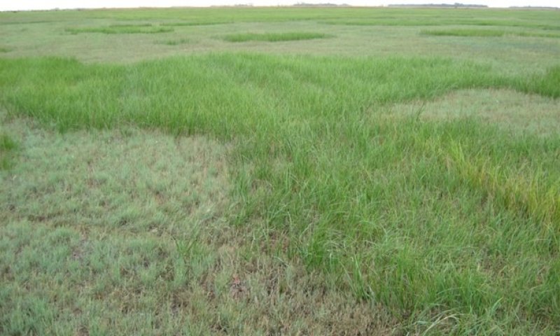
Figure 1. Sodic Subirrigated - a mosaic of vegetation caused by variable depths to the claypan (restrictive root) layer.
Table 1. Dominant plant species
| Tree |
Not specified |
|---|---|
| Shrub |
Not specified |
| Herbaceous |
(1) Andropogon gerardii |
Physiographic features
This site occurs on flats and shallow depressions on sandy lake plains and delta plains. Slopes are <2 percent.
Table 2. Representative physiographic features
| Landforms |
(1)
Flat
(2) Depression |
|---|---|
| Runoff class | Negligible to low |
| Flooding frequency | None |
| Ponding duration | Long (7 to 30 days) |
| Ponding frequency | None to occasional |
| Elevation | 750 – 1,475 ft |
| Slope | 2% |
| Ponding depth | 12 in |
| Water table depth | 42 in |
| Aspect | Aspect is not a significant factor |
Climatic features
MLRA 56A is considered to have a continental climate – cold winters and relatively hot summers, low to moderate humidity, light rainfall, and much sunshine. Extremes in temperature may also abound. The climate is the result of this MLRA’s location near the geographic center of North America. There are few natural barriers on the northern Great Plains and air masses move freely across the plains and account for rapid changes in temperature.
Annual precipitation typically ranges from 18 to 23 inches per year. The average annual temperature is about 40°F. January is the coldest month with average temperatures ranging from about 1°F (Pembina, North Dakota (ND) to about 11°F (Wheaton, Minnesota (MN). July is the warmest month with temperatures averaging from about 68°F (Pembina, ND) to about 73°F (Wheaton, MN). The range of normal average monthly temperatures between the coldest and warmest months is about 65°F. This large annual range attests to the continental nature of this area's climate. Winds are estimated to average about 13 miles per hour annually, ranging from about 15 miles per hour during the spring to about 11 miles per hour during the summer. Daytime winds are generally stronger than nighttime and occasional strong storms may bring brief periods of high winds with gusts to more than 50 miles per hour.
Growth of cool season plants begins in early to mid-March, slowing or ceasing in late June. Warm season plants begin growth about mid-May and continue to early or mid-September. Greening up of cool season plants may occur in September and October when adequate soil moisture is present.
Table 3. Representative climatic features
| Frost-free period (characteristic range) | 102-126 days |
|---|---|
| Freeze-free period (characteristic range) | 132-145 days |
| Precipitation total (characteristic range) | 21-24 in |
| Frost-free period (actual range) | 87-131 days |
| Freeze-free period (actual range) | 126-150 days |
| Precipitation total (actual range) | 20-25 in |
| Frost-free period (average) | 112 days |
| Freeze-free period (average) | 138 days |
| Precipitation total (average) | 22 in |
Figure 2. Monthly precipitation range
Figure 3. Monthly minimum temperature range
Figure 4. Monthly maximum temperature range
Figure 5. Monthly average minimum and maximum temperature
Figure 6. Annual precipitation pattern
Figure 7. Annual average temperature pattern
Climate stations used
-
(1) PEMBINA [USW00014924], Pembina, ND
-
(2) GRAFTON [USC00323594], Grafton, ND
-
(3) PARK RIVER [USC00326857], Park River, ND
-
(4) VICTOR 4 NNE [USC00398652], Rosholt, SD
-
(5) WHEATON [USC00218907], Wheaton, MN
-
(6) AGASSIZ REFUGE [USC00210050], Grygla, MN
Influencing water features
During the months of March through July, typically, the water table is within a depth of 18 inches and lowers to a depth of 1.5 to 3.5 feet for the remainder of the growing season. Depending on the density and thickness of the claypan layer, ponding in depressions may be frequent in the spring or after heavy, summer rainfall. Surface infiltration is moderate to moderately rapid; permeability through the claypan subsoil is moderately slow to moderate. Water loss is through evapotranspiration and percolation below the root zone.
Soil features
Soils associated with Sodic Subirrigated ES are in the Mollisol order. The Mollisols are further classified as Typic Natraquolls. These soils were developed under prairie vegetation. They formed in sandy glaciolacustrine sediments or deltaic deposits. The soils on this site are very deep; however, there is a claypan layer which restricts root growth.
The soils in this site are poorly drained with redoximorphic features within a depth of 18 inches. The surface texture is typically sandy loam, fine sandy loam, or loam but loamy fine sand and loamy sand are included. The texture of the claypan layer is typically sandy loam, fine sandy loam, or loam, but sandy clay loam also occurs.
Soil salinity, typically, is none or very slight (E.C. <4 dS/m) to a depth of >20 inches; however, slightly saline (E.C. 4-8 dS/m) is allowable. In some soils, salinity may increase to moderate (E.C. 8-16 dS/m) below a depth of 20 inches.
Where the surface layer is more than 3 inches thick (Reference and Native/Invaded States), sodicity is relatively low (SAR <8); however, in the “Thin State” (claypan within a depth of 3 inches), SAR values in the surface layer may be as high as 30. In the sodic subsoil layer (claypan), SAR values are commonly between 10 and 20 in the Thick State; but they are 20 to >40 in the Thin State.
In the Thick Reference State, soil reaction is slightly alkaline or moderately alkaline (pH 7.4 to 8.4) in the surface layer and moderately alkaline to very strongly alkaline (pH 7.9 to 9.0) in the subsoil and substratum. The Thin State is moderately alkaline (pH 7.9 to 8.4) in the surface layer and strongly alkaline to very strongly alkaline (pH 8.5 to 9.6) in the subsoil and substratum.
Calcium carbonate content typically ranges from 0 to 10 percent in the surface layer of all states. In the subsoil, it typically ranges from 3 to 25 percent in the subsoil to a depth of 20 inches in both States.
The soil surface is stable and intact. Sub-surface soil layers can be restrictive to water movement and root penetration. These soils are susceptible to wind and water erosion. The hazard of erosion increases where vegetative cover is not adequate. A drastic loss of the soil surface layer on this site can result in a shift in species composition and/or production.
The major soil series correlated to the Sodic Subirrigated site is Stirum.
Access Web Soil Survey (https://websoilsurvey.sc.egov.usda.gov/App/WebSoilSurvey.aspx) for specific local soils information.
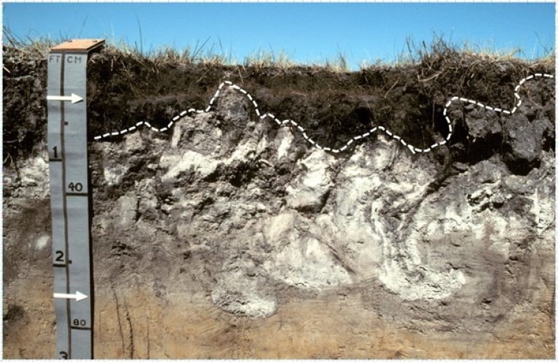
Figure 8. Sodic Subirrigated is represented by Stirum soils. White dashed line indicates variable depth below the A and/or E horizon to Btn horizon (claypan). Photo from USDA-NRCS (1985) depicting variable depth to Btn.
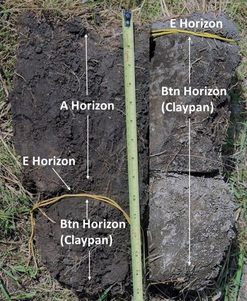
Figure 9. Sodic Subirrigated soil profiles. Right soil ped: Thin-Reference, approximately 1 inch of E horizon above the Btn horizon (claypan). Left soil ped: Thick-Reference, 10 inches of A horizon above Btn horizon (claypan).
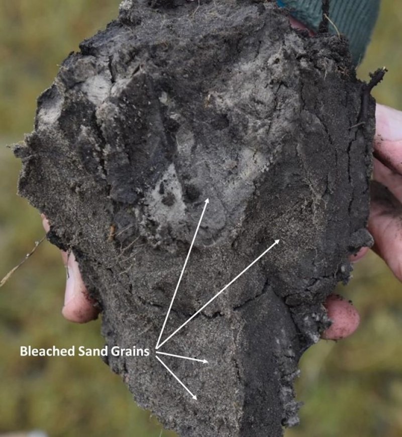
Figure 10. Stirum soils often have very coarse columnar structure. The faces of the columns exhibit bleached sand grains which have a grayish color.
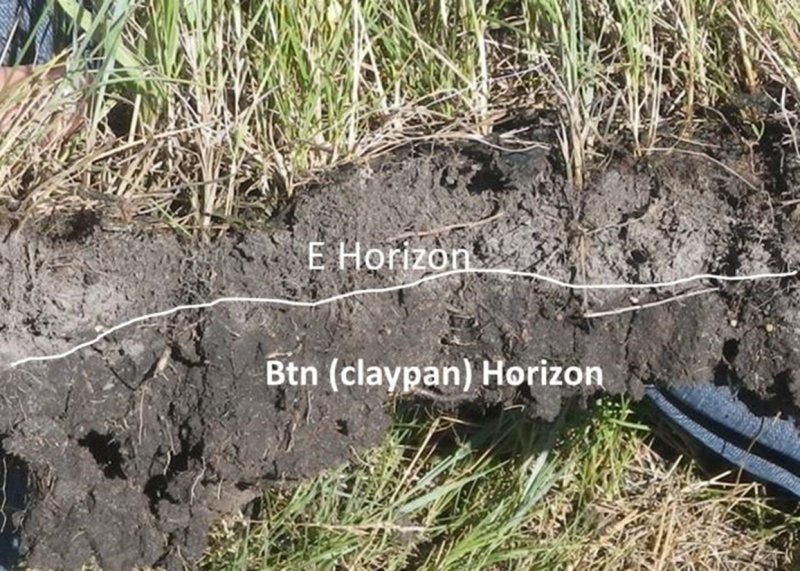
Figure 11. Thin-Native/Invaded State. Note the gray colored E horizon directly above claypan
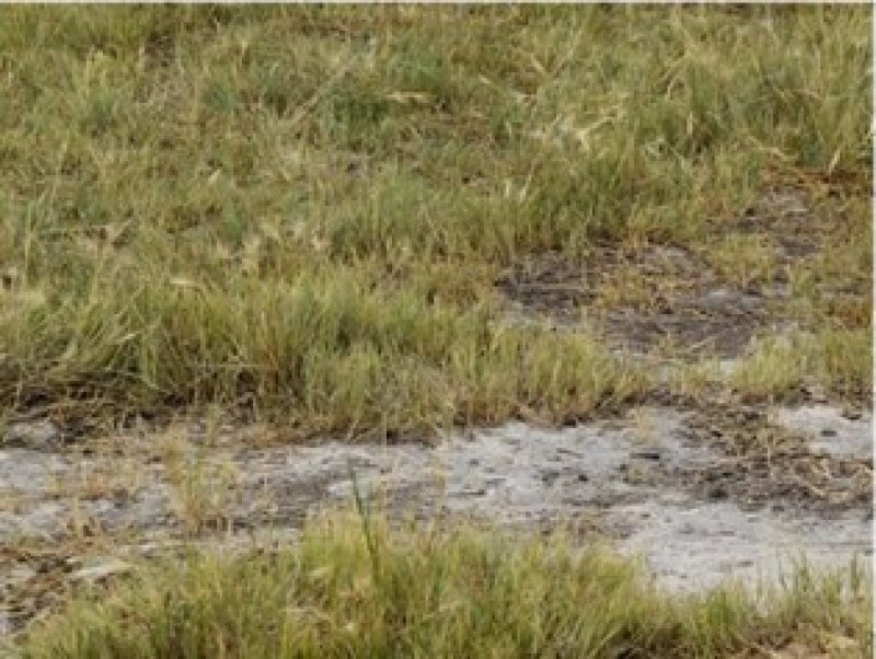
Figure 12. Thin-Native/Invaded State with lack of vegetative cover.
Table 4. Representative soil features
| Parent material |
(1)
Glaciolacustrine deposits
(2) Glaciofluvial deposits (3) Lacustrine deposits (4) Outwash |
|---|---|
| Surface texture |
(1) Fine sandy loam (2) Sandy loam (3) Loam (4) Loamy fine sand (5) Loamy sand |
| Family particle size |
(1) Loamy |
| Drainage class | Poorly drained |
| Permeability class | Moderately slow to moderate |
| Depth to restrictive layer | 3 – 13 in |
| Soil depth | 80 in |
| Surface fragment cover <=3" | 14% |
| Surface fragment cover >3" | Not specified |
| Available water capacity (0-40in) |
3 – 8 in |
| Calcium carbonate equivalent (0-20in) |
25% |
| Electrical conductivity (0-20in) |
8 mmhos/cm |
| Sodium adsorption ratio (0-40in) |
3 – 40 |
| Soil reaction (1:1 water) (0-40in) |
7.4 – 9.6 |
| Subsurface fragment volume <=3" (Depth not specified) |
14% |
| Subsurface fragment volume >3" (Depth not specified) |
Not specified |
Ecological dynamics
This ecological site description is based on nonequilibrium ecology and resilience theory and utilizes a State-and-Transition Model (STM) diagram to organize and communicate information about ecosystem change as a basis for management. The ecological dynamics characterized by the STM diagram reflect how changes in ecological drivers, feedback mechanisms, and controlling variables can maintain or induce changes in plant community composition (phases and/or states). The application of various management actions, combined with weather variables, impact the ecological processes which influence the competitive interactions, thereby maintaining or alter plant community structure.
Sodic Subirrigated ecological sites are typically located on flats and shallow depressions on sandy lake plains and delta plains, often lying on the landscape below the Limy Subirrigated, Sandy Claypan, and Thin Claypan ecological sites and above the Shallow Marsh sites. Sodic Subirrigated sites are often closely intermingled with other ecological sites due to slight differences in micro- topography, depth to the claypan layer, salinity, sodicity, and other factors. As a result, a mosaic of ecological sites, states, and community phases are often found within short distances (feet).
A consequence of the considerable variations in states and community phases within short distances on Sodic Subirrigated sites are conspicuous variations in plant height, plant density, and annual production. Extra care must be given when interpreting these variations in the plant community to avoid mistaking these conditions as overgrazed/undergrazed patterns typically referred to as patch grazing. More detailed soil observations are necessary to properly interpret these variations.
Prior to European influence, the historical disturbance regime for MLRA 56A included frequent fires, both anthropogenic and natural in origin. Most fires, however, were anthropogenic fires set by Native Americans. Native Americans set fires in all months except perhaps January. These fires occurred in two peak periods, one from March-May with the peak in April and another from July-November with the peak occurring in October. Most of these fires were scattered and of small extent and duration. The grazing history would have involved grazing and browsing by large herbivores (such as American bison, elk, and whitetail deer). Herbivory by small mammals, insects, nematodes, and other invertebrates are also important factors influencing the production and composition of the plant communities. Grazing and fire interaction, particularly when coupled with drought events, influenced the dynamics discussed and displayed in the following state and transition diagram and descriptions.
Following European influence, this ecological site generally has had a history of grazing by domestic livestock, particularly cattle, which along with other related activities (e.g., fencing, water development, fire suppression) has changed the disturbance regime of the site. Changes will occur in the plant communities due to these and other factors.
Weather fluctuations coupled with managerial factors may lead to changes in the plant communities and may, under adverse impacts, result in a slow decline in vegetative vigor and composition. However, under favorable conditions the botanical composition may resemble that prior to European influence. The biological integrity of this site may be maintained more readily through prescribed grazing and burning since repetitive haying over several years may reduce native grass species vigor and production, subsequently increasing exotic cool-season grasses.
Five vegetative states have been identified for the site (Reference, Thick Native/Invaded, Thin Native/Invaded, Thick-Invaded, and Go-Back). Within each state, one or more community phases have been identified. These community phases are named based on the more dominant and visually conspicuous species; they have been determined by study of historical documents, relict areas, scientific studies, and ecological aspects of plant species and plant communities. Transitional pathways and thresholds have been determined through similar methods.
State 1: Reference (Mosaic) represents the natural range of variability that dominated the dynamics of this ecological site prior to European influence. Dynamics were largely determined by variations in soil chemistry (e.g., sodicity), climate, and weather (e.g., precipitation/freeze thaw cycles), as well as that of fire (e.g., timing, frequency), and grazing by native herbivores (e.g., frequency, intensity, selectivity).
A mosaic of states, and community phases are often found within short distances (i.e., feet) due to slight differences in microtopography, depth to the claypan layer, salinity, sodicity, and other factors. Largely due to variations in the thickness of the A horizon, the Reference State is thought to have consisted of a Thick-Reference (1.1) characterized by tall warm-season grasses and a Thin- Reference (1.2) characterized by cool-season grasses (see Figure 7).
Presently, the primary disturbances are due to the widespread introduction of exotic plants, concentrated livestock grazing, lack of fire, annual haying, and perhaps long-term non-use or very light grazing, and no fire. Because of these changes, particularly the widespread occurrence of exotic plants, as well as other environmental changes, the Reference State is considered to no longer exist. Thus, the presence of exotic plants on the site precludes it from being placed in the Reference State. It must then be placed in one of the other states.
State 2: Thick-Native/Invaded State. Colonization of 1.1 Thick-Reference by exotic plants results in a transition to State 2: Thick-Native/Invaded State (T1A). This transition was inevitable; it often resulted from colonization by exotic cool-season grasses (e.g., Kentucky bluegrass, smooth brome, quackgrass) which have been particularly and consistently invasive under long-term non-use or very light grazing, and no fire. Other exotic plants (e.g., Canada thistle, leafy spurge) are also known to invade the site.
Three community phases have been identified for this state; they are similar to 1.1 Thick-Reference but has been invaded by exotic cool-season grasses. These exotic cool-season grasses can be expected to increase. As that increase occurs, plants more desirable to wildlife and livestock may decline. A decline in forb diversity can also be expected. Under non-use or minimal use management, mulch increases and may become a physical barrier to plant growth. This also changes the micro-climate near the soil surface and may alter infiltration, nutrient cycling, and biological activity near the soil surface. As a result, these factors combined with shading cause desirable native plants to have increasing difficulty remaining viable and recruitment declines.
To slow or limit the invasion of these exotic cool-season grasses or other exotic plants, it is imperative that managerial techniques (e.g., prescribed grazing, prescribed burning) be carefully constructed, monitored, and evaluated with respect to that objective. If management does not include measures to control or reduce these exotic plants, the transition to State 4: Invaded State (T2A). The threshold to this transition is reached when both the exotic cool-season grasses exceed 30% of the plant community and native grasses represent less than 40% of the community.
State 3: Thin Native/Invaded State. Colonization of 1.2 Thin-Reference by exotic plants results in a transition to State 3: Thin-Native/Invaded State (T1B). The thin A horizon and shallow depth to claypan limits the extent that exotic plants will invade this site. Foxtail barley and saltgrass have increased and are more likely to become dominant. Vegetation may become sparse with areas of bare ground. The site, however, has been invaded by exotic cool-season grasses/forbs.
State 4: Thick-Invaded State. The threshold for this state is reached when both the exotic cool- season grasses exceed 30% of the plant community and native grasses represent less than 40% of the community. One plant community phase has been identified for this state.
The exotic cool-season grasses can be quite invasive and often form monotypic stands. As they increase, both forage quantity and quality of the annual production becomes increasingly restricted to late spring and early summer, even though annual production may increase. Forb diversity often declines. Under non-use or minimal use management, mulch can increase and become a physical barrier to plant growth which alters nutrient cycling, infiltration, and soil biological activity. As such, desirable native plants become increasingly displaced.
Once the state is well established, prescribed burning and prescribed grazing techniques have been largely ineffective in suppressing or eliminating the exotic cool-season grasses, even though some short-term reductions may appear successful. However, assuming there is an adequate component of native grasses to respond to treatments, a restoration pathway to State 2: Thick Native/Invaded State may be accomplished with the implementation of long-term prescribed grazing in conjunction with prescribed burning (R4A).
State 5: Go-Back State often results following cropland abandonment and consists of only one plant community phase. This weedy assemblage may include noxious weeds that need control. Over time, the exotic cool-season grasses (e.g., Kentucky bluegrass, smooth brome, quackgrass) will likely predominate.
Initially, due to extensive bare ground and a preponderance of shallow rooted annual plants, infiltration is low and the potential for soil erosion is high. Plant species richness may be high, but overall diversity (i.e., equitability) is typically low with the site dominated by a relatively small assemblage of species. Due to the lack of native perennials and other factors, such as depth to claypan and compaction impacted by tillage, restoring the site with the associated ecological processes is difficult. However, a successful range planting may result in something approaching State 2: Thick-Native/Invaded State (R5B) or to State 3: Thin-Native/Invaded State (R5A). Following seeding, prescribed grazing, prescribed burning, haying, and the use of herbicides will generally be necessary to achieve the desired result and control weeds, some of which may be noxious weeds. A failed range planting and/or secondary succession will lead to State 4: Thick-Invaded State (R5C).
The plant community phase composition table(s) has been developed from the best available knowledge including research, historical records, clipping studies, and inventory records. As more data are collected, plant community species composition and production information may be revised.
State and transition model
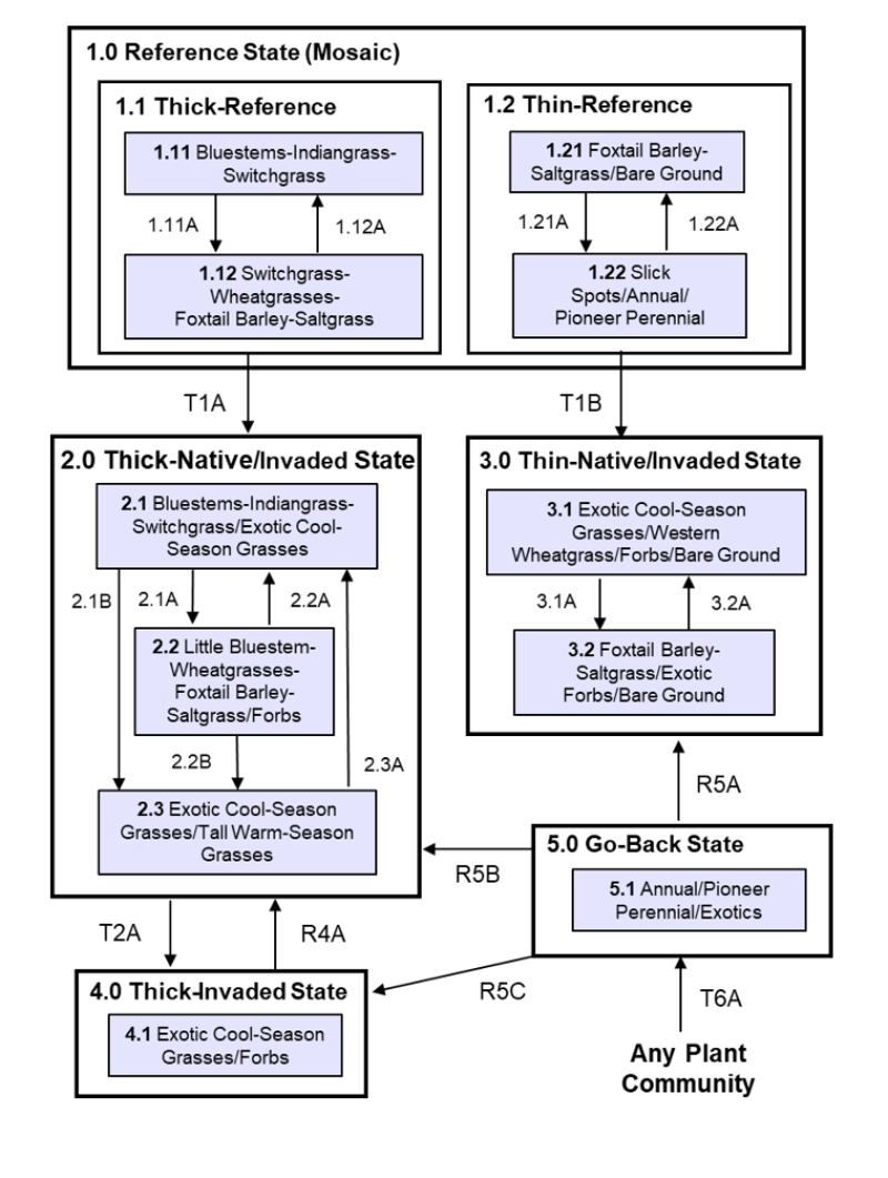
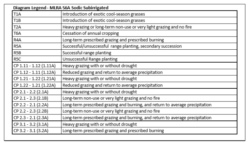
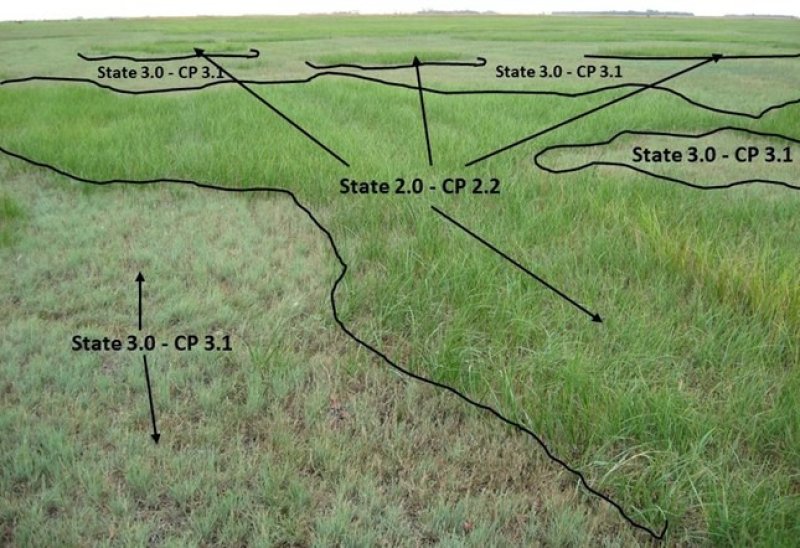
Figure 13. Intermingled states and community phases on the landscape due to slight to moderate variations in microrelief, depth to claypan layer, soil chemistry, and other factors.
More interactive model formats are also available.
View Interactive Models
More interactive model formats are also available.
View Interactive Models
Click on state and transition labels to scroll to the respective text
Ecosystem states
States 2 and 5 (additional transitions)
| T1A | - | Introduction of exotic cool-season grasses |
|---|---|---|
| T1B | - | Introduction of exotic cool-season grasses |
| T2A | - | Heavy grazing or long-term non-use or very light grazing and no fire. |
| R4A | - | Long-term prescribed grazing and prescribed burning. |
| R5B | - | Successful range planting |
| R5A | - | Successful/unsuccessful range planting, secondary succession. |
| R5C | - | Unsuccessful range planting. |
| T6A | - | Cessation of annual cropping |
State 1 submodel, plant communities
| 1.11A | - | Heavy grazing with or without drought. |
|---|---|---|
| 1.12A | - | Reduced grazing and return to average precipitation. |
| 1.21A | - | Heavy grazing with or without drought. |
| 1.22A | - | Reduced grazing and return to average precipitation. |
State 2 submodel, plant communities
| 2.1A | - | Heavy grazing with or without drought |
|---|---|---|
| 2.1B | - | Long-term non-use or very light grazing and no fire. |
| 2.2A | - | Long-term prescribed grazing and burning, and return to average precipitation. |
| 2.2B | - | Long-term non-use or very light grazing and no fire. |
| 2.3A | - | Long-term prescribed grazing and burning, and return to average precipitation. |
State 3 submodel, plant communities
| 3.1A | - | Heavy grazing with or without drought. |
|---|---|---|
| 3.2A | - | Long-term prescribed grazing and prescribed burning. |
State 4 submodel, plant communities
State 5 submodel, plant communities
State 1
Reference State (Mosaic)
This plant community represents the natural range of variability that dominated the dynamics of this ecological site prior to European influence. Dynamics of the state were largely determined by variations in sodicity, climate and weather (e.g., precipitation/freeze thaw cycles), as well as that of fire (e.g., timing, frequency) and grazing by native herbivores (e.g., frequency, intensity, selectivity). A mosaic of states, and community phases were often found within short distances (i.e., feet) due to slight differences in microtopography, depth to the claypan layer, salinity, sodicity, and other factors. Largely due to variations in the thickness of the A horizon, the Reference State is thought to have consisted of a Thick-Reference (1.1) characterized by tall warm-season grasses and a Thin- Reference (1.2) characterized by cool-season grasses (see Figure 7). State 1.1 Thick-Reference State This state is represented by a thick A horizon (depth to claypan ranging from 3 to 13 inches) dominated by tall warm-season grasses and a diversity of forbs. Salinity ranged from an E.C. of 0 to 8 dS/m. E.C. ratings below 6 would have had little effect on plant growth or diversity. Higher E.C. levels may begin to effect plant diversity and growth. However, the sodium absorption ratio (SAR) can range from 3 to 20, negatively impacted plant growth once SARs reached 10 or greater. State 1.2 Thin-Reference State This state is represented by a thin A horizon with depth to claypan of less than 3 inches. The shallow depth to claypan limited plant diversity favoring plants that could tolerate a restrictive root layer (claypan). The shallow depth to claypan also correlated to a high sodium absorption ratio (SAR of 20 to 40) and a strongly to very strongly alkaline soil reaction class (pH 8.5 to 9.6), severely impacting plant growth. The plant community was dominated by short-statured grasses, such as foxtail barley and inland saltgrass, with a low diversity of forbs.
Characteristics and indicators. (i.e., characteristics that can be used to distinguish this state from others). Because of changes in disturbances and other environmental factors (particularly the widespread occurrence of exotic species), the Reference State is considered to no longer exist.
Resilience management. (i.e., management strategies that will sustain a state and prevent a transition). If intact, the reference state should probably be managed with current disturbance regimes which has permitted the site to remain in reference condition, as well as maintaining the quality and integrity of associated ecological sites. Maintenance of the reference condition is contingent upon a monitoring protocol to guide management.
Community 1.1
Thick-Reference (1.11) Bluestems-Indiangrass-Switchgrass (Andropogon gerardii, Schizachryium scoparium-Sorghastrum nutans-Panicum virgatum)
Warm-season grasses dominated this plant community with cool-season grasses being subdominant. The major grasses and sedges include big bluestem, little bluestem, Indiangrass, switchgrass, along with western wheatgrass, slender wheatgrass, plains bluegrass, and sedges. Common forbs often include common yarrow, woolly plantain, white sagebrush, curlycup gumweed, scarlet globemallow, white heath aster, and leafy wild parsley. Annual production varied from about 3200-5000 pounds per acre with grasses/grass-likes, forbs, and shrubs contributing about 85%, 10% and 5%, respectively. This reference state represents the plant community phases upon which interpretations are primarily based and is described in the “Plant Community Composition and Group Annual Production” portion of this ecological site description.
Figure 14. Annual production by plant type (representative values) or group (midpoint values)
Table 5. Annual production by plant type
| Plant type | Low (lb/acre) |
Representative value (lb/acre) |
High (lb/acre) |
|---|---|---|---|
| Grass/Grasslike | 2720 | 3485 | 4250 |
| Forb | 320 | 410 | 500 |
| Shrub/Vine | 160 | 205 | 250 |
| Total | 3200 | 4100 | 5000 |
Community 1.2
Thick-reference (1.12) Switchgrass-Wheatgrasses-Foxtail Barley-Saltgrass (Panicum virgatum-Pascopyrum smithii, Elymus trachycaulus-Hordeum jubatum-Distichlis spicata)
Heavy grazing with or without drought resulted in increases of more grazing tolerant grasses and forbs compared to that of Community Phase 1.11. Western wheatgrass, slender wheatgrass, foxtail barley, and saltgrass have increased, while tall warm-season grasses have decreased. Common forbs include common yarrow, curlycup gumweed, white sagebrush, white heath aster, and field pussytoes. Annual production is somewhat reduced compared to that of Community Phase 1.11 with a reduced contribution from tall warm- season grasses.
Community 1.3
Thin-Reference (1.21) Foxtail Barley-Saltgrass/Bare Ground (Hordeum jubatum- Distichlis spicata/Bare Ground)
Patches of foxtail barley and saltgrass were well distributed throughout the community with tall warm-season grasses nearly absent. Bare ground may have developed in micro-lows. Common forbs may have included curlycup gumweed, common yarrow, Pursh seepweed, scarlet globemallow, lambsquarters, and common pepperweed. Annual production and plant diversity was variable dependent upon the amount of bare ground.
Figure 15. Annual production by plant type (representative values) or group (midpoint values)
Table 6. Annual production by plant type
| Plant type | Low (lb/acre) |
Representative value (lb/acre) |
High (lb/acre) |
|---|---|---|---|
| Grass/Grasslike | 935 | 1190 | 1785 |
| Forb | 110 | 140 | 210 |
| Total | 1045 | 1330 | 1995 |
Community 1.4
Thin-Reference (1.22) Slick Spots/ Annual/ Pioneer Perennial
This community phase resulted from heavy grazing with or without drought. The claypan layer was at (or close to) the surface and is sparsely vegetated. Plants common in this community phase included bushy knotweed, field pussytoes, scarlet globemallow, woolly plantain, Pursh seepweed, common yarrow, and curlycup gumweed.
Pathway 1.11A
Community 1.1 to 1.2
Community Phase Pathway 1.11 (plant community 1.1) to 1.12 (plant community 1.2) occurred with heavy grazing with or without drought, resulting in marked decreases in big bluestem and Indiangrass along with corresponding increases in wheatgrass, foxtail barley, and saltgrass.
Pathway 1.12A
Community 1.2 to 1.1
Community Phase Pathway 1.12 (plant community 1.2) to 1.11 (plant community 1.1) occurred with reduced grazing and a return to average precipitation. This has resulted in marked increases in big bluestem and Indiangrass along with corresponding decreases in wheatgrass, foxtail barley, and saltgrass.
Pathway 1.21A
Community 1.3 to 1.4
Community Phase Pathway 1.21 (plant community 1.3) to 1.22 (plant community 1.4) occurred with heavy grazing with or without drought, resulting in marked increases in foxtail barley and bare ground.
Pathway 1.22A
Community 1.4 to 1.3
Community Phase Pathway 1.22 (plant community 1.4) to 1.21 (plant community 1.4) occurred with reduced grazing and a return to average precipitation. This resulted in increases in foxtail barley and saltgrass.
State 2
Thick-Native/Invaded State
This state is similar to 1.1 Thick-Reference but has now been colonized by the exotic cool-season grasses (e.g., Kentucky bluegrass, smooth brome, quackgrass, or perhaps redtop) which are now present in small amounts. Although the state is still dominated by native grasses, an increase in the exotic cool-season grasses can be expected. The exotic cool-season grasses can be quite invasive on the site and are particularly well adapted to heavy grazing. They also often form monotypic stands. As these exotic cool-season grasses increase, both forage quantity and quality become increasingly restricted to late spring and early summer due to the monotypic nature of the stand, even though annual production may increase. Native forbs generally decrease in production, abundance, diversity, and richness compared to that of State 1.1: Thick-Reference State. These exotic cool-season grasses have been particularly and consistently invasive under extended periods of non-use and no fire. To slow or limit the invasion of these exotic cool-season grasses, it is imperative that managerial techniques (e.g., prescribed grazing, prescribed burning) be carefully constructed, monitored, and evaluated with respect to that objective. If management does not include measures to control or reduce these exotic cool-season grasses, the transition to State 4: Thick- Invaded State should be expected. Annual production of this state can be quite variable, in large part due to the amount of exotic cool-season grasses.
Characteristics and indicators. (i.e., characteristics that can be used to distinguish this state from others). The presence of trace amounts of exotic cool-season grasses indicates a transition from State 1 to State 2. The presence of exotic biennial or perennial leguminous forbs (i.e., sweet clover, black medic) may not, on their own, indicate a transition from State 1 to State 2 but may facilitate that transition.
Resilience management. (i.e., management strategies that will sustain a state and prevent a transition). To slow or limit the invasion of these exotic grasses, it is imperative that managerial techniques (e.g., prescribed grazing, prescribed burning) be carefully constructed, monitored, and evaluated with respect to that objective. Grazing management should be applied that enhances the competitive advantage of native grass and forb species. This may include: (1) early spring grazing when exotic cool-season grasses are actively growing and native cool-season grasses are dormant; (2) applying proper deferment periods allowing native grasses to recover and maintain or improve vigor; (3) adjusting overall grazing intensity to reduce excessive plant litter (above that needed for rangeland health indicator #14 – see Rangeland Health Reference Worksheet); (4) incorporating early heavy spring utilization which focuses grazing pressure on exotic cool-season grasses and reduces plant litter, provided that livestock are moved when grazing selection shifts from exotic cool-season grasses to native grasses. Prescribed burning should be applied in a manner that maintains or enhances the competitive advantage of native grass and forb species. Prescribed burns should be applied as needed to adequately reduce/remove excessive plant litter and maintain the competitive advantage for native species. Timing of prescribed burns (spring vs. summer vs. fall) should be adjusted to account for differences in annual growing conditions and applied during windows of opportunity to best shift the competitive advantage to the native species.
Community 2.1
Bluestems-Indiangrass-Switchgrass/Exotic Cool-Season Grasses (Andropogon gerardii, Schizachryium scoparium-Sorghastrum nutans-Panicum virgatum/Exotic Cool-Season Grasses)

Figure 16. Community Phase 2.1: Bluestems-Indiangrass-Switchgrass/Exotic Cool-Season Grasses – Native warm-season grasses on thick surface intermingled with exotic cool-season grasses occupying Thick-Native/Invaded State.
This community phase is similar to Thick-Reference State Community Phase 1.11 but has been colonized by exotic cool-season grasses (e.g., Kentucky bluegrass, smooth brome, quackgrass). However, these exotics are present in smaller amounts with the community still dominated by native grasses. Common forbs often include common yarrow, white sagebrush, white heath aster, leafy wildparsley, red clover, sweetclover, and black medic. Annual production may be comparable to that of Community Phase 1.11 (3200-5000 pounds per acre). However, as the exotic cool-season grasses increase, peak production will shift to earlier in the growing season.
Community 2.2
Little Bluestem-Wheatgrasses-Foxtail Barley-Saltgrass (Schizachyrium scoparium,-Pascopyrum smithii, Elymus trachycaulus-Hordeum jubatum-Distichlis spicata)
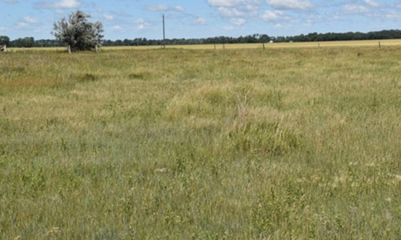
Figure 17. Community Phase 2.2: Little Bluestem-Wheatgrass-Foxtail Barley-Saltgrass – Native warm-season grasses on thick surface intermingled with foxtail barley occupying Thick-Native/Invaded State.
This community phase results from heavy grazing with increases in the more grazing tolerant grasses and forbs compared to that of Community Phase 2.1. Little bluestem is conspicuously abundant due to the calcium carbonates in the soil and limited utilization by livestock. This Community Phase is similar to Community Phase 1.12 but has now been colonized by exotic cool-season grasses (e.g., Kentucky bluegrass, smooth brome, quackgrass). These exotics, however, are present in minor amounts with the community still dominated by native grasses.
Community 2.3
Exotic Cool-Season Grasses/Tall Warm-Season Grasses

Figure 18. Community Phase 3.1 intermingled with Community Phase 2.3.
This community phase is approaching the threshold leading to a transition to State 5: Invaded State. As a result, it is an “at risk” community. If management does not include measures to control or reduce these exotic cool-season grasses, the transition to State 4: Invaded State should be expected.
Pathway 2.1A
Community 2.1 to 2.2
Community Phase Pathway 2.1 to 2.2 occurs with heavy grazing with or without drought. Heavy grazing favors grazing tolerant species, such as western wheatgrass, foxtail barley, and saltgrass. Little bluestem and grazing tolerant forbs (e.g., gumweed) may also increase under heavy grazing.
Pathway 2.1B
Community 2.1 to 2.3
Community Phase Pathway 2.1 to 2.3 occurs with long-term non-use or very light grazing, is conspicuously abundant due to the calcium carbonates in the soil and low utilization by livestock. The exotic cool-season grasses markedly increase, and the warm-season grasses become conspicuously present. Long-term haying during the warm-season critical growth period favors exotic cool-season grasses.
Pathway 2.2A
Community 2.2 to 2.1
Depending upon climatic conditions, Community Phase Pathway 2.2 to 2.1 occurs with the implementation of long-term prescribed grazing and prescribed burning and return to average precipitation. As the pathway progresses, grasses such as wheatgrass, foxtail barley, and saltgrass) decrease and a more diverse forb component often increases.
Pathway 2.2B
Community 2.2 to 2.3
Community Phase Pathway 2.2 to 2.3 occurs with long-term non-use or very light grazing and no fire. This results in a marked increase in the exotic cool-season grasses with the warm-season grasses conspicuously present.
Pathway 2.3A
Community 2.3 to 2.1
Community Phase Pathway 2.3 to 2.1 occurs with the implementation of long-term prescribed grazing and prescribed burning and return to average precipitation. This results in a marked decrease in the exotic cool- season grasses and corresponding increase in the tall warm-season grasses (e.g., big bluestem).
State 3
Thin-Native/Invaded State
This state is similar to State 1.2: Thin-Reference State but has now been invaded by exotic cool- season grasses (e.g., Kentucky bluegrass, smooth brome, quackgrass). Other exotic plants (e.g., leafy spurge) may are also known to invade the site. But due to soil chemistry (high sodicity and pH) and soil structure (claypan at or near the surface), exotic species may remain as a minor component.
Characteristics and indicators. (i.e., characteristics that can be used to distinguish this state from others). The presence of trace amounts of exotic cool-season grasses indicates a transition from State 1 to State 2. The presence of exotic biennial or perennial leguminous forbs (i.e., sweet clover, black medic) may not, on their own, indicate a transition from State 1 to State 2 but may facilitate that transition.
Resilience management. (i.e., management strategies that will sustain a state and prevent a transition). To slow or limit the invasion of these exotic grasses, it is imperative that managerial techniques (e.g., prescribed grazing, prescribed burning) be carefully constructed, monitored, and evaluated with respect to that objective. Grazing management should be applied that enhances the competitive advantage of native grass and forb species. This may include: (1) early spring grazing when exotic cool-season grasses are actively growing and native cool-season grasses are dormant; (2) applying proper deferment periods allowing native grasses to recover and maintain or improve vigor; (3) adjusting overall grazing intensity to reduce excessive plant litter (above that needed for rangeland health indicator #14 – see Rangeland Health Reference Worksheet); (4) incorporating early heavy spring utilization which focuses grazing pressure on exotic cool-season grasses and reduces plant litter, provided that livestock are moved when grazing selection shifts from exotic cool-season grasses to native grasses. Prescribed burning should be applied in a manner that maintains or enhances the competitive advantage of native grass and forb species. Prescribed burns should be applied as needed to adequately reduce/remove excessive plant litter and maintain the competitive advantage for native species. Timing of prescribed burns (spring vs. summer vs. fall) should be adjusted to account for differences in annual growing conditions and applied during windows of opportunity to best shift the competitive advantage to the native species.
Community 3.1
Exotic Cool-Season Grasses/ Western Wheatgrass/ Forbs/Bare Ground (Exotic Cool-Season Grasses/ Pascopyrum smithii/ Forbs/ Bare Ground)
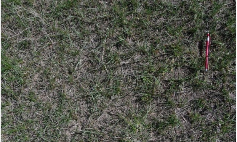
Figure 19. Community Phase 3.1: Exotic Cool-Season Grasses/Western Wheatgrass/Forbs/Bare Ground.
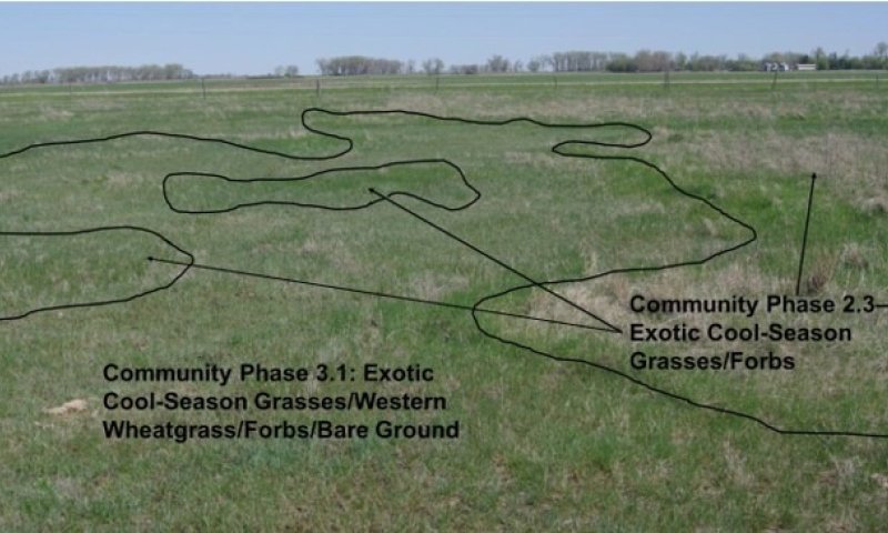
Figure 20. Community Phase 3.1 intermingled with Community Phase 2.3.
This community may be characterized by the abundance of exotic cool-season grasses (e.g., Kentucky bluegrass, smooth brome, quackgrass) and conspicuous western wheatgrass, forbs, and bare ground. Common forb species may include curlycup gumweed, common yarrow, Pursh seepweed, scarlet globemallow, lambsquarters, and common pepperweed.
Community 3.2
Foxtail Barley-Saltgrass/ Exotic Forbs/ Bare Ground (Hordeum jubatum-Distichlis spicata/ Exotic Forbs/Bare Ground)
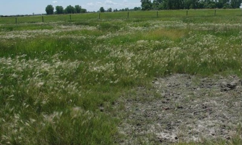
Figure 21. Community Phase 3.2: Foxtail Barley-Saltgrass/Exotic Forbs/Bare Ground - Thin-Native/Invaded dominated by foxtail barley with bare ground.
This community phase is similar to Community Phase 1.21 except for the invasion of exotic forbs and exotic cool-season grasses (e.g., Kentucky bluegrass, smooth brome, quackgrass). Patches of bare ground (like those shown in Figure 13) are well distributed throughout the foxtail barley and saltgrass community. Common forb species may include curlycup gumweed, common yarrow, Pursh seepweed, scarlet globemallow, lambsquarters, and common pepperweed. Annual production and plant diversity is variable dependent upon the amount of bare ground.
Pathway 3.1A
Community 3.1 to 3.2
Community Phase Pathway 3.1 to 3.2. occurs with heavy grazing with or without drought. This leads to marked increases in foxtail barley, saltgrass, and exotic forbs (e.g., black medic, sweetclover, red clover, curly dock, lambsquarters, common plantain, and Canada thistle).
Pathway 3.2A
Community 3.2 to 3.1
Community Phase Pathway 3.2 to 3.1. occurs with the implementation of long-term prescribed grazing and prescribed burning. This leads to marked decreases in foxtail barley, saltgrass, and exotic forbs with corresponding increases in the exotic cool-season grasses (e.g., Kentucky bluegrass, smooth brome, quackgrass), western wheatgrass, and native forbs.
State 4
Thick-Invaded State
This state is the result of invasion and dominance by the exotic cool-season grasses (e.g., Kentucky bluegrass, smooth brome, quackgrass) on sites with thick surface. They often form monotypic stands. As these exotic cool-season grasses increase, both forage quantity and quality become increasingly restricted to late spring and early summer due to the monotypic nature of the stand, even though annual production may increase. These exotic cool-season grasses can invade the site and are particularly well adapted to heavy grazing. Native forbs generally decrease in production, abundance, diversity, and richness compared to that of State 1: Reference State. Common forbs often include black medic, red clover, and sweetclover. Shrubs, such as prairie sagewort and wild rose, show marked increases. Leafy spurge may also invade the site. Once the state is well established, prescribed burning and grazing techniques have been largely ineffective in suppressing or eliminating these species, even though some short-term reductions may appear successful. Annual production of this state may vary widely, in part due to variations in the extent of invasion by exotic cool-season grasses.
Characteristics and indicators. (i.e., characteristics that can be used to distinguish this state from others). This site is characterized by exotic cool-season grasses constituting greater than 30 percent of the annual production and native grasses constituting less than 40 percent of the annual production.
Resilience management. (i.e., management strategies that will sustain a state and prevent a transition). Light or moderately stocked continuous, season-long grazing or a prescribed grazing system which incorporates adequate deferment periods between grazing events and proper stocking rate levels will maintain this State. Application of herbaceous weed treatment, occasional prescribed burning and/or brush management may be needed to manage noxious weeds and increasing shrub (e.g., western snowberry) populations.
Community 4.1
Exotic Cool-Season Grasses/Forbs
Figure 22. Community Phase 4.1 - Exotic Cool-Season Grasses/Forbs Dominated by Kentucky bluegrass and smooth brome.
This community phase is dominated by exotic cool-season grasses (e.g., Kentucky bluegrass, smooth brome, quackgrass) with a conspicuous forb component. Common forbs often include black medic, red clover, and sweetclover along with shrubs (such as prairie sagewort and wild rose). The exotic forbs, Canada thistle and leafy spurge, may also invade the site.
State 5
Go-Back State
This state is highly variable depending on the level and duration of disturbance related to the T6A transitional pathway. Annual tillage, in most cases, does not redistribute sodium between the Thick- Reference and Thin-Reference State. The main factor determining plant growth and restoration is the depth to the restrictive root zone (claypan) and soil chemistry (high SARs and alkalinity). In this MLRA, the most probable origin of this state is plant succession following cropland abandonment. This plant community will initially include a variety of annual forbs and grasses, some of which may be noxious weeds and need control. Over time, the exotic cool-season grasses (e.g., Kentucky bluegrass, smooth brome, quackgrass) will likely predominate. Common forb and shrub associates may include black medic, sweetclover, red clover, curly dock, lambsquarters, plantain, Canada thistle, and wild rose.
Characteristics and indicators. (i.e., characteristics that can be used to distinguish this state from others). Tillage has destroyed the native plant community, altered soil structure and biology, reduced soil organic matter, and resulted in the formation of a tillage induced compacted layer which is restrictive to root growth. Removal of perennial grasses and forbs results in decreased infiltration and increased runoff.
Resilience management. (i.e., management strategies that will sustain a state and prevent a transition). Continued tillage will maintain the state. Control of noxious weeds will be required.
Community 5.1
Annual/Pioneer Perennial
This community phase is highly variable depending on the level and duration of disturbance related to the T6A transitional pathway. Depth to the root restrictive claypan will influence plant growth and diversity that reestablishes on this site. In this MLRA, the most probable origin of this phase is secondary succession following cropland abandonment. This plant community will initially include a variety of annual forbs and grasses including noxious weeds (e.g., Canada thistle) which may need control. Over time, the exotic cool- season grasses (Kentucky bluegrass, smooth brome, and/or quackgrass) will likely predominate on the thick sites.
State 6
Any Plant Community
Transition T1A
State 1 to 2
This is the transition from the State 1 Reference State (Mosaic) 1.1 Thick-Reference to the State 2: Thick-Native/Invaded State resulting from the introduction and establishment of exotic cool-season grasses (e.g., Kentucky bluegrass, smooth brome, quackgrass). Other exotic plants (e.g., leafy spurge) are also known to invade the site. This transition was inevitable and corresponded to a decline in native warm-season and cool-season grasses; it may have been exacerbated by chronic season-long or heavy late season grazing or long-term annual haying. Complete rest from grazing and suppression of fire could also have hastened the transition. The threshold between states was crossed when Kentucky bluegrass, smooth brome, quackgrass, or other exotic plants became established on the site.
Constraints to recovery. (i.e., variables or processes that preclude recovery of the former state). Current knowledge and technology will not facilitate a successful restoration to Reference State.
Transition T1B
State 1 to 3
This is the transition from the State 1: Reference State (Mosaic) 1. 2 Thin-Reference to the State 3: Thin-Native/Invaded State resulting from the introduction and establishment of exotic cool-season grasses (e.g., Kentucky bluegrass, smooth brome, quackgrass). Other exotic plants (e.g., leafy spurge) are also known to invade the site. This transition was inevitable and corresponded to a decline in native warm-season and cool-season grasses; it may have been exacerbated by chronic season-long or heavy late season grazing or long-term annual haying. Complete rest from grazing and suppression of fire could also have hastened the transition. The threshold between states was crossed when Kentucky bluegrass, smooth brome, quackgrass, or other exotic plants became established on the site.
Constraints to recovery. (i.e., variables or processes that preclude recovery of the former state). Current knowledge and technology will not facilitate a successful restoration to Reference State.
Transition T2A
State 2 to 4
This is the transition from the State 2: Thick-Native/Invaded State to State 4: Thick-Invaded State due to heavy grazing or long-term non-use or very light grazing, and no fire. Exotic cool-season grasses (e.g., quackgrass, Kentucky bluegrass, smooth brome) become the dominant graminoids. Soil conditions related to thick surface (depth to claypan) and soil chemistry of the surface layer (low sodicity, salinity, and pH) allow these exotic cool-season grasses to exceed the threshold. This transition may occur under other managerial conditions, including annual haying. Studies indicate that a threshold may exist in this transition when both the exotic cool-season grasses exceed 30% of the plant community and native grasses represent less than 40% of the plant community composition.
Constraints to recovery. (i.e., variables or processes that preclude recovery of the former state). Variations in growing conditions (e.g., cool, wet spring) will influence effects of various management activities on exotic cool-season grass populations.
Restoration pathway R4A
State 4 to 2
This restoration pathway from State 4: Thick-Invaded State to Thick-Native/Invaded State 2: Thick Native/Invaded State may be accomplished with the implementation of long-term prescribed grazing and prescribed burning, assuming there is an adequate component of native grasses to respond to the treatments. Both prescribed grazing and prescribed burning are likely necessary to successfully initiate this restoration pathway, the success of which depends upon the presence of a remnant population of native grasses in Community Phase 4.1. That remnant population, however, may not be readily apparent without close inspection. The application of several prescribed burns may be needed at relatively short intervals in the early phases of this restoration process, in part because some shrubs may sprout profusely following one burn. Early season prescribed burns have been successful; however, fall burning may also be an effective technique to favor native warm-season grasses. The results of the timing and intensity of burns has been mixed as to the impacts on exotic cool-season grasses. The prescribed grazing should include adequate recovery periods following each grazing event and stocking levels which match the available resources. If properly implemented, this will shift the competitive advantage from the exotic cool-season grasses to the native cool-season grasses.
Context dependence. (i.e., factors that cause variations in plant community shifts, restoration likelihood, and contribute to uncertainty). Grazing management should be applied in a manner that enhances/maximizes the competitive advantage of native grass and forb species over the exotic species. This may include the use of prescribed grazing to reduce excessive plant litter accumulations above that needed for rangeland health indicator #14 (see Rangeland Health Reference Worksheet). Increasing livestock densities may facilitate the reduction in plant litter provided length and timing of grazing periods are adjusted to favor native species. Grazing prescriptions designed to address exotic grass invasion and favor native species may involve earlier, short, intense grazing periods with proper deferment to improve native species health and vigor. Fall (e.g., September, October) prescribed burning followed by an intensive, early spring graze period with adequate deferment for native grass recovery may shift the competitive advantage to the native species, facilitating the restoration to State 2: Native/Invaded. Prescribed burning should be applied in a manner that enhances the competitive advantage of native grass and forb species over the exotic species. Prescribed burns should be applied at a frequency which mimics the natural disturbance regime, or more frequently as is ecologically (e.g., available fuel load) and economically feasible. Burn prescriptions may need adjustment to: (1) account for change in fine fuel orientation (e.g., “flopped” Kentucky bluegrass); (2) fire intensity and duration by adjusting ignition pattern (e.g., backing fires vs head fires); (3) account for plant phenological stages to maximize stress on exotic species while favoring native species (both cool- and warm-season grasses).
Restoration pathway R5B
State 5 to 2
This restoration pathway from State 5: Go-Back State to State 3: Thick-Native/Invaded State may result from a successful range planting. Site-specific seeding mixes need to be developed; refer to the plant community table. A highly diverse seed mix will more than likely be necessary with species adapted to both thick and thin soil conditions.
Context dependence. (i.e., factors that cause variations in plant community shifts, restoration likelihood, and contribute to uncertainty). A successful range planting will include proper seedbed preparation, weed control (both prior to and after the planting), selection of adapted native species representing functional/structural groups inherent to the State 1, and proper seeding technique. Management (e.g., prescribed grazing, prescribed burning) during and after establishment must be applied in a manner that maintains the competitive advantage for the seeded native species. Adding non-native species can impact the above and below ground biota. Elevated soil nitrogen levels have been shown to benefit smooth brome and Kentucky bluegrass more than some native grasses. As a result, fertilization, exotic legumes in the seeding mix, and other techniques that increase soil nitrogen may promote smooth brome and Kentucky bluegrass invasion. The method or methods of herbaceous weed treatment will be site specific to each situation; generally, the goal would be to apply the pesticide, mechanical control, or biological control (either singularly or in combination) in a manner that shifts the competitive advantage from the targeted species to the native grasses and forbs. The control method(s) should be as specific to the targeted species as possible to minimize impacts to non-target species.
Restoration pathway R5A
State 5 to 3
This restoration pathway from State 5: Go-Back State to State 3: Thin-Native/Invaded State may result from a successful range planting. Seeding mixes need to be developed accordingly, refer to plant community table. A highly diverse seed will more than likely be necessary with species adapted to both thick and thin soil conditions.
Context dependence. (i.e., factors that cause variations in plant community shifts, restoration likelihood, and contribute to uncertainty). A successful range planting will include proper seedbed preparation, weed control (both prior to and after the planting), selection of adapted native species representing functional/structural groups inherent to the State 1, and proper seeding technique. Management (e.g., prescribed grazing, prescribed burning) during and after establishment must be applied in a manner that maintains the competitive advantage for the seeded native species. Adding non-native species can impact the above and below ground biota. Elevated soil nitrogen levels have been shown to benefit smooth brome and Kentucky bluegrass more than some native grasses. As a result, fertilization, exotic legumes in the seeding mix, and other techniques that increase soil nitrogen may promote smooth brome and Kentucky bluegrass invasion. The method or methods of herbaceous weed treatment will be site specific to each situation; generally, the goal would be to apply the pesticide, mechanical control, or biological control (either singularly or in combination) in a manner that shifts the competitive advantage from the targeted species to the native grasses and forbs. The control method(s) should be as specific to the targeted species as possible to minimize impacts to non-target species.
Restoration pathway R5C
State 5 to 4
This restoration pathway from 5: Go-Back State to State 4: Thick-Invaded State may result from a failed range planting and/or secondary succession. A failed restoration is more likely if the Go-Back State has a thin surface over the claypan. It is unclear whether a failed range planting on an eroded Go-Back State would lead to State 4: Thick-Invaded State. The exotic cool-season grasses may not be able to out-compete the native grasses. The failed range planting would then lead to State 3: Thin- Native/Invaded State.
Context dependence. (i.e., factors that cause variations in plant community shifts, restoration likelihood, and contribute to uncertainty). Failed range plantings can result from many causes (both singularly and in combination) including drought, poor seedbed preparation, improper seeding methods, seeded species not adapted to the site, insufficient weed control, herbicide carryover, poor seed quality (purity & germination), and/or improper management.
Restoration pathway T6A
State 6 to 5
This transition is from any plant community to State 6: Go-back State. It is most commonly associated with the cessation of cropping without the benefit of range planting, resulting in a “go-back” situation. Soil conditions can be quite variable on the site, in part due to variations in the management/cropping history (e.g., development of a plowline, erosion, fertility, and/or herbicide/pesticide carryover). Thus, soil conditions should be assessed when considering restoration techniques.
Additional community tables
Table 7. Community 1.1 plant community composition
| Group | Common name | Symbol | Scientific name | Annual production (lb/acre) | Foliar cover (%) | |
|---|---|---|---|---|---|---|
|
Grass/Grasslike
|
||||||
| 1 | Tall Warm-Season Grasses | 820–1640 | ||||
| big bluestem | ANGE | Andropogon gerardii | 410–1230 | – | ||
| Indiangrass | SONU2 | Sorghastrum nutans | 205–615 | – | ||
| switchgrass | PAVI2 | Panicum virgatum | 205–615 | – | ||
| prairie cordgrass | SPPE | Spartina pectinata | 41–410 | – | ||
| 2 | Mid Warm-Season Grasses | 410–1025 | ||||
| little bluestem | SCSC | Schizachyrium scoparium | 615–1230 | – | ||
| sideoats grama | BOCU | Bouteloua curtipendula | 0–205 | – | ||
| 3 | Cool-Season Grasses | 205–615 | ||||
| western wheatgrass | PASM | Pascopyrum smithii | 41–410 | – | ||
| slender wheatgrass | ELTR7 | Elymus trachycaulus | 41–410 | – | ||
| plains bluegrass | POAR3 | Poa arida | 41–205 | – | ||
| foxtail barley | HOJU | Hordeum jubatum | 0–41 | – | ||
| 4 | Short Warn-Season Grasses | 123–410 | ||||
| saltgrass | DISP | Distichlis spicata | 41–82 | – | ||
| mat muhly | MURI | Muhlenbergia richardsonis | 0–41 | – | ||
| 5 | Other Native Grasses | 0–205 | ||||
| prairie Junegrass | KOMA | Koeleria macrantha | 41–123 | – | ||
| Graminoid (grass or grass-like) | 2GRAM | Graminoid (grass or grass-like) | 41–123 | – | ||
| Scribner's rosette grass | DIOLS | Dichanthelium oligosanthes var. scribnerianum | 0–41 | – | ||
| 6 | Grass-Likes | 41–205 | ||||
| sedge | CAREX | Carex | 41–328 | – | ||
| Grass-like (not a true grass) | 2GL | Grass-like (not a true grass) | 0–205 | – | ||
| spikerush | ELEOC | Eleocharis | 0–123 | – | ||
|
Forb
|
||||||
| 7 | Forbs | 205–410 | ||||
| Forb (herbaceous, not grass nor grass-like) | 2FORB | Forb (herbaceous, not grass nor grass-like) | 41–205 | – | ||
| common yarrow | ACMI2 | Achillea millefolium | 41–123 | – | ||
| woolly plantain | PLPA2 | Plantago patagonica | 41–123 | – | ||
| textile onion | ALTE | Allium textile | 41–82 | – | ||
| white sagebrush | ARLU | Artemisia ludoviciana | 41–82 | – | ||
| curlycup gumweed | GRSQ | Grindelia squarrosa | 41–82 | – | ||
| scarlet globemallow | SPCO | Sphaeralcea coccinea | 41–82 | – | ||
| white heath aster | SYER | Symphyotrichum ericoides | 41–82 | – | ||
| leafy wildparsley | MUDI | Musineon divaricatum | 0–82 | – | ||
| field pussytoes | ANNE | Antennaria neglecta | 0–41 | – | ||
| field sagewort | ARCA12 | Artemisia campestris | 0–41 | – | ||
| field chickweed | CEAR4 | Cerastium arvense | 0–41 | – | ||
| wavyleaf thistle | CIUN | Cirsium undulatum | 0–41 | – | ||
| foothill bladderpod | LELU | Lesquerella ludoviciana | 0–41 | – | ||
| rush skeletonplant | LYJU | Lygodesmia juncea | 0–41 | – | ||
| scarlet beeblossom | OESU3 | Oenothera suffrutescens | 0–41 | – | ||
| bushy knotweed | PORA3 | Polygonum ramosissimum | 0–41 | – | ||
| silverleaf Indian breadroot | PEAR6 | Pediomelum argophyllum | 0–41 | – | ||
| goldenrod | SOLID | Solidago | 0–41 | – | ||
| Nuttall's violet | VINU2 | Viola nuttallii | 0–41 | – | ||
|
Shrub/Vine
|
||||||
| 8 | Shrubs | 41–205 | ||||
| leadplant | AMCA6 | Amorpha canescens | 41–123 | – | ||
| prairie sagewort | ARFR4 | Artemisia frigida | 41–82 | – | ||
| prairie rose | ROAR3 | Rosa arkansana | 41–82 | – | ||
| western snowberry | SYOC | Symphoricarpos occidentalis | 41–82 | – | ||
| Shrub (>.5m) | 2SHRUB | Shrub (>.5m) | 0–82 | – | ||
Table 8. Community 1.3 plant community composition
| Group | Common name | Symbol | Scientific name | Annual production (lb/acre) | Foliar cover (%) | |
|---|---|---|---|---|---|---|
|
Grass/Grasslike
|
||||||
| 1 | Wheatgrasses | 420–700 | ||||
| western wheatgrass | PASM | Pascopyrum smithii | 420–630 | 30–45 | ||
| slender wheatgrass | ELTR7 | Elymus trachycaulus | 0–70 | 0–5 | ||
| 2 | Short-Warm-Season Grasses | 210–350 | ||||
| blue grama | BOGR2 | Bouteloua gracilis | 14–70 | 1–5 | ||
| saltgrass | DISP | Distichlis spicata | 14–70 | 1–5 | ||
| scratchgrass | MUAS | Muhlenbergia asperifolia | 0–28 | 0–2 | ||
| tumblegrass | SCPA | Schedonnardus paniculatus | 0–28 | 0–2 | ||
| buffalograss | BODA2 | Bouteloua dactyloides | 0–28 | 0–2 | ||
| 3 | Cool-Season Bunchgrasses | 14–70 | ||||
| Nuttall's alkaligrass | PUNU2 | Puccinellia nuttalliana | 14–70 | 1–5 | ||
| needle and thread | HECOC8 | Hesperostipa comata ssp. comata | 0–42 | 0–3 | ||
| 4 | Other Native Grasses | 14–210 | ||||
| foxtail barley | HOJU | Hordeum jubatum | 70–140 | 5–10 | ||
| Graminoid (grass or grass-like) | 2GRAM | Graminoid (grass or grass-like) | 0–70 | 0–5 | ||
| prairie Junegrass | KOMA | Koeleria macrantha | 14–70 | 1–5 | ||
| Sandberg bluegrass | POSE | Poa secunda | 0–14 | 0–1 | ||
| plains bluegrass | POAR3 | Poa arida | 0–14 | 0–1 | ||
| 5 | Grass-Likes | 14–70 | ||||
| needleleaf sedge | CADU6 | Carex duriuscula | 14–42 | 1–3 | ||
| arctic rush | JUAR2 | Juncus arcticus | 0–42 | 0–3 | ||
| Grass-like (not a true grass) | 2GL | Grass-like (not a true grass) | 0–28 | 0–2 | ||
|
Forb
|
||||||
| 6 | Forbs | 28–140 | ||||
| Forb (herbaceous, not grass nor grass-like) | 2FORB | Forb (herbaceous, not grass nor grass-like) | 14–70 | 1–5 | ||
| common yarrow | ACMI2 | Achillea millefolium | 14–42 | 1–3 | ||
| woolly plantain | PLPA2 | Plantago patagonica | 14–42 | 1–3 | ||
| textile onion | ALTE | Allium textile | 14–28 | 1–2 | ||
| white sagebrush | ARLU | Artemisia ludoviciana | 14–28 | 1–2 | ||
| curlycup gumweed | GRSQ | Grindelia squarrosa | 14–28 | 1–2 | ||
| scarlet globemallow | SPCO | Sphaeralcea coccinea | 14–28 | 1–2 | ||
| white heath aster | SYER | Symphyotrichum ericoides | 14–28 | 1–2 | ||
| leafy wildparsley | MUDI | Musineon divaricatum | 0–28 | 0–2 | ||
| field pussytoes | ANNE | Antennaria neglecta | 0–14 | 0–1 | ||
| field sagewort | ARCA12 | Artemisia campestris | 0–14 | 0–1 | ||
| foothill bladderpod | LELU | Lesquerella ludoviciana | 0–14 | 0–1 | ||
| rush skeletonplant | LYJU | Lygodesmia juncea | 0–14 | 0–1 | ||
| bushy knotweed | PORA3 | Polygonum ramosissimum | 0–14 | 0–1 | ||
| silverleaf Indian breadroot | PEAR6 | Pediomelum argophyllum | 0–14 | 0–1 | ||
| Pursh seepweed | SUCA2 | Suaeda calceoliformis | 0–14 | 0–1 | ||
|
Shrub/Vine
|
||||||
| 7 | Shrubs | 14–70 | ||||
| prairie sagewort | ARFR4 | Artemisia frigida | 14–42 | 1–3 | ||
| broom snakeweed | GUSA2 | Gutierrezia sarothrae | 0–28 | 0–2 | ||
| prairie rose | ROAR3 | Rosa arkansana | 0–28 | 0–2 | ||
| Shrub (>.5m) | 2SHRUB | Shrub (>.5m) | 0–28 | 0–2 | ||
Interpretations
Animal community
Animal Community – Wildlife Interpretations
Landscape
The MLRA 56A landscape is characterized by a nearly level glacial lake plain bordered on the east and west by outwash plains, till plains, gravelly beaches, and dunes. MLRA 56A is considered to have a continental climate with cold winters and hot summers, low humidity, light rainfall, and much sunshine. Extremes in temperature are common and characteristic of the MLRA. This area supports natural tall-grass prairie vegetation with bur oak, green ash, and willow growing in drainageways. This area is formed in silty and clayey lacustrine sediments from the former Glacial Lake Agassiz. Complex intermingled ecological sites create diverse grass/shrub land habitats interspersed with varying densities of linear, slope, depressional, and in-stream wetlands associated with headwater streams and tributaries to the Red River of the North. MLRA 56A is located within the boundaries of the Prairie Pothole Region and is an ecotone between the humid east and the sub-humid west regions. The primary land use is annual cropland (~80%). The Red River Valley is known for its exceptional fertility with major crops including corn, soybeans, small grains, and sugar beets.
By the mid-19th century, the majority of the Red River Valley had been converted from tall-grass prairie to annual crop production. To alleviate crop production loss from wetlands and overland flow, a system of shallow surface ditches, judicial ditches, and road ditches removes surface water in spring and during high rainfall events. The major soils are poorly drained with extensive areas of saline soils. Tile drainage systems have been or are being extensively installed throughout MLRA 56A for sub-surface field drainage to enhance annual crop production.
The east and west side of the Red River Valley formed in a complex pattern of sandy beach material, stratified inter-beach material, lacustrine silts, and lake washed glacial till. The soils vary from excessively drained on ridges to very poorly drained organic basins. Surface ditches serve to drain some of the area, although much of the area lacks adequate drainage for maximum crop production. Calcareous fens and saline seeps can occur at the base of beach ridges and result in rare plant communities. Native vegetation was mixed- and tall-grass prairie with scattered woodland and brush.
Historic Communities/Conditions within MLRA 56A:
The northern tall- and mixed-grass prairie was a disturbance-driven ecosystem with fire, herbivory, and climate functioning as the primary ecological drivers (either singly or often in combination). Frequent and expansive flooding along the Red River and its tributaries provided abundant opportunities for Native Americans to harvest wild rice. American bison roamed MLRA 56A wintering along the Red River and migrating west into MLRA 55A and 55B for parts of the season. Many species of grassland birds, small mammals, insects, reptiles, amphibians, and large herds of roaming American bison, elk, and pronghorn were historically among the inhabitants adapted to this region. Roaming herbivores, as well as several small mammal and insect species, were the primary consumers linking the grassland resources to large predators (such as the wolf and American black bear) and smaller carnivores (such as the coyote, bobcat, red fox, and raptors). Extirpated species include free-ranging American bison and gray wolf (breeding). Extinct from the region is the Rocky Mountain locust.
Present Communities/Conditions within MLRA 56A:
MLRA 56A has the most conversion to cropland of any MLRA within Region F-Northern Great Plains. European influence has impacted remaining grassland and shrubland by domestic livestock grazing, elimination of fire, removal of surface and subsurface hydrology via artificial drainage, and other anthropogenic factors influencing plant community composition and abundance.
Extensive drainage has taken place. Streams have been straightened (removing sinuosity) and riparian zones have been converted to annual crop production. These anthropogenic impacts have reduced flood water detention and retention on the landscape, increasing storm water runoff, sediment, and nutrient loading to the Red River and its tributaries. The installation of instream structures has reduced aquatic species movement within the MLRA.
Annual cropping is the main factor contributing to habitat fragmentation, reducing habitat quality for area-sensitive species. These influences fragmented the landscape, reduced, or eliminated ecological drivers (fire), and introduced exotic species including smooth brome, Kentucky bluegrass, and leafy spurge which further impacted plant and animal communities. The loss of the bison and fire as primary ecological drivers greatly influenced the character of the remaining native plant communities and the associated wildlife, moving towards a less diverse and more homogeneous landscape.
Included in this MLRA are approximately 70,000 acres of the United States Forest Service, Sheyenne National Grassland (southern portion of MLRA) with an additional 65,000 acres of intermingled privately owned land of sandy soils providing a large tract of intact tall grass prairie within the MLRA. United Fish and Wildlife Service refuges and waterfowl production areas, along with and state wildlife management areas cover approximately 67,000 acres within the MLRA. Two of three largest cities in North Dakota are located within the MLRA.
USDA conservation programs have seeded thousands of cropland acres in riparian zones to native herbaceous vegetation. Natural succession is replacing the planted native herbaceous vegetation to native woody vegetation re-establishing native wooded riparian areas on previously cropland. Most of the plantings have been along the Red River and its tributaries in the northern portions of the MLRA within the United States. These areas are privately owned and protected from annual agricultural production with perpetual conservation easements.
Some characteristic wildlife species in this area are:
Birds: Mallard, blue-winged teal, red-tailed hawk, American kestrel, ring-necked pheasant, western meadowlark, killdeer, eastern and western kingbird, American crow, common yellowthroat, downy and hairy woodpecker, clay-colored sparrow, vesper sparrow, Savannah sparrow, and brown-headed cowbird.
Mammals: Northern short-tailed shrew, white-tailed jackrabbit, snowshoe hare, Franklin’s ground squirrel, thirteen-lined ground squirrel, northern pocket gopher, plains pocket gopher, western harvest mouse, deer mouse, meadow vole, meadow jumping mouse, western jumping mouse, coyote, red fox, raccoon, American badger, striped skunk, white-tailed deer, North American beaver, and moose.
Reptiles/Amphibians: American toad, Great Plains toad, northern leopard frog, chorus frog, tree frog, tiger salamander, plains garter snake, and common garter snake.
Presence of wildlife species is often determined by ecological site characteristics including grass and forb species, hydrology, aspect, and other associated ecological sites. The home ranges of most species are usually larger than one ecological site or are dependent upon more than one ecological site for annual life requisites. Ecological sites offer different habitat elements as the annual life requisites change. Habitat improvement and creation must be conducted within the mobility limits of a known population for the species.
Insects play an important role providing ecological services for plant community development. Insects that are scavengers or aid in decomposition provide the food chain baseline sustaining the carnivorous insects feeding upon them. Many insects provide the ecological services necessary for pollination, keeping plant communities healthy and productive. Insects provide a protein food source for numerous species including grassland-nesting birds and their young. Extensive use of insecticides for specialty crops (such as potatoes, sugar beets, and other crops) has greatly reduced insects within this MLRA.
Species of Concern within MLRA 56A:
The following is a list of species considered “species of conservation priority” in the North Dakota State Wildlife Action Plan (2015); “species of greatest conservation need” in the Minnesota State Wildlife Action Plan, Conservation Focus Areas, Target Species (2015) and the South Dakota State Wildlife Action Plan (2014); and “species listed as threatened, endangered, or petitioned” under the Endangered Species Act within MLRA 56A at the time this section was developed:
Invertebrates: Arogos skipper, Assiniboia skipper, Dakota skipper, dusted skipper, Leonard’s skipper, monarch butterfly, Poweshiek skippering, red-tailed leafhopper, regal fritillary, and Uhler’s Arctic.
Birds: American kestrel, American bittern, bobolink, American white pelican, bald eagle, black-billed cuckoo, chestnut-collared longspur, Dickcissel, grasshopper sparrow, greater prairie-chicken, Henslow’s sparrow, LeConte’s sparrow, loggerhead shrike, marbled godwit, Nelson’s sparrow, northern harrier, northern pintail, red-headed woodpecker, sharp-tailed grouse, short-eared owl, Swainson’s hawk, upland sandpiper, western meadowlark, willet, Wilson’s phalarope, and yellow rail.
Mammals: Arctic shrew, big brown bat, eastern spotted skunk, gray fox, little brown bat, northern grasshopper mouse, plains pocket mouse, prairie vole, pygmy shrew, Richardson’s ground squirrel, and river otter.
Amphibians/Reptiles: Canadian toad, common snapping turtle, northern prairie skink, and plains hognose snake.
Fish: Blacknose shiner, blue sucker, burbot, chestnut lamprey, finescale dace, hornyhead chub, largescale stoneroller, logperch, northern pearl dace, northern redbelly dace, pearl dace, shortnose gar, sickle-fin chub, sliver chub, silver lamprey, trout-perch, and yellow bullhead.
Mussels: Black sandshell, creek heelsplitter, creeper, mapleleaf, pink heelsplitter, pink papershell, threeridge, and Wabash pigtoe.
Grassland Management for Wildlife in MLRA 56A:
Management activities within the community phase pathways have both short and long term positive and negative impacts on wildlife. Community phase, transitional, and restoration pathways are keys to long-term management within each State and between States. Significant inputs must occur to cross the threshold between States (e.g., State 3.0 to 2.0) requiring substantial economic inputs and management (grazing intensity, reseeding, prescribed fire, woody vegetation removal, etc.). Timing, intensity, and frequency of these inputs can have dramatic positive or negative effects on vegetative structure impacting local wildlife species’ habitats. Ranchers and other land managers must always consider the long-term beneficial effects of management on the habitat in comparison to potential short-term negative effects to individual species.
Ecological sites occur as intermingled complexes on the landscape with gradual or sometimes abrupt transitions. Rarely do ecological sites exist in large enough acreage to manage independently. Ecological sites supporting a dominance of herbaceous vegetation (Wet Meadow, Subirrigated Sands) can be located adjacent to ecological sites that support trees (Choppy Sands and Loamy Overflow).
Management of these complex ecological sites can provide a heterogeneous or a homogenous landscape. Grassland bird use reduces as the plant community transitions to a homogenous state or increases in woody vegetation. Managers need to recognize ecological sites and the complexes they occur in to properly manage the landscape. A management regime for one ecological site may negatively impact an adjacent site (e.g., alteration of a grazing regime within a Choppy Sands ecological site to encourage understory growth may encourage exotic cool- season grasses to increase or dominate an adjacent ecological site).
Life requisites and habitat deficiencies are determined for targeted species. Deficiencies need to be addressed along community phase, transitional, and restoration pathways as presented in specific state-and-transition models. Ecological sites should be managed and restored within the site’s capabilities to provide sustainable habitat. Managers also must consider habitat provided by adjacent/intermingled ecological sites for species with home ranges or life requisites that cannot be provided by one ecological site.
With populations of many grassland-nesting birds in decline, it is important to maintain these ecological sites in a 1.0 Reference State or the 2.0 Native/Invaded State. Plant communities optimal for a guild of grassland species serve as a population source where the birth rate exceeds mortality. Species may use marginal plant communities; however, these sites may function as a population sink where mortality exceeds the birth rate.
Understanding preferred vegetative stature and sensitivity to woody encroachment is necessary to manage for the specific grassland species. Various grass heights may be used for breeding, nesting, or foraging habitat. While most species use varying heights, many have a preferred vegetative stature height. The following chart provides preferred vegetative stature heights and sensitivity to woody vegetation encroachment.
To see the chart please follow the hyperlink. ( https://efotg.sc.egov.usda.gov/#/state/ND/search )
Sodic Subirrigated Wildlife Habitat Interpretation:
Sodic Subirrigated ecological sites have parent material that is very deep; however, a root-restrictive, dense, sodic claypan subsoil is within a depth of 13 inches. The claypan layer restricts root growth. Commonly, there is a mosaic of vegetation caused by variable depths to the claypan layer (and associated SAR and pH values). The vegetation mosaic consists of tall statured vegetation (bluestems, Indiangrass, switchgrass) in association with sodic tolerant, short statured vegetation (foxtail barley, saltgrass, and bare ground). Wildlife species response will be dependent on the amount of each type of vegetation within the mosaic. Associated ecological sites commonly include Saline Lowland, Limy Subirrigated, Sandy Claypan, Shallow Marsh, and Wet Meadow. This complex of ecological sites provides habitat for many edge-sensitive, grassland bird species preferring short-, medium- and tall-statured vegetation.
Sodic Subirrigated habitat features and components commonly support grassland-nesting birds that prefer varied statured vegetation. Tall-statured and short-statured vegetation occurs in a mosaic creating a patchy landscape. Depending on the patch size of the varied statured vegetation grassland nesting birds will respond differently. Low diversity and density of forb species provide limited pollen and nectar resources for pollinating insects. In turn, invertebrate production is low, providing limited protein resources for grassland-nesting birds. Sodic Subirrigated ecological sites provide forage for small and large herbivores.
Sodic Subirrigated ecological sites may be found in five plant community states (1.0 Reference State (Mosaic), 2.0 Thick-Native/Invaded State, 3.0 Thin-Native/Invaded State,
4.0 Thick-Invaded State, and 5.0 Go-Back State) within a local landscape. Multiple plant community phases exist within States 1.0, 2.0, and 3.0. Today, these states occur primarily in response to drought, fire, grazing, and non-use, and other anthropogenic disturbances.
Because there is no known restoration pathway from State 2.0 to State 1.0, it is important to intensively manage using Community Phase Pathways in State 1.0 to prevent further plant community degradation along the T1A and T1B Transitional Pathways to State 2.0 and State 3.0. Native wildlife generally benefits from the heterogeneous grasslands found in States 1.0 and 2.0 that include grass and forb species of varying stature and density. As plant communities degrade and transition to State 4.0, exotic cool-season grass increase while native forbs are reduced.
Management along community phase, transition, or restoration pathways should focus upon attainable changes. Short- and long-term monetary costs must be evaluated against short- and long-term ecological services in creating and maintaining habitat of enough quality to support a sustainable population density.
1.1 Thick-Reference
Community Phase 1.11 Bluestems-Indiangrass-Switchgrass: This plant community offers tall statured vegetative wildlife habitat and occurs in a mosaic with short statured vegetation. This phase retains high functionality through continued maintenance including prescribed grazing with adequate recovery period, as well as prescribed burning. Predominance of grass species in this community favors grazers and mixed-feeders (animals selecting grasses as well as forbs and shrubs). The structural diversity provides habitat for a wide array of migratory and resident birds.
Invertebrates: Insects play a role in maintaining the forb community and provide a forage base for grassland birds, reptiles, and rodents. Ecological services, historically provided by American bison, are simulated by domestic livestock. These services include putting plant material and dung in contact with mineral soil to be used by low trophic level consumers (such as invertebrate decomposers, scavengers, shredders, predators, herbivores, dung beetles and fungal feeders).
Dakota skippers do not prefer this site due to limited host plants (such as woody lily, harebell, and smooth camas). Regal fritillary habitat is limited due to Nuttall's violet and prairie violets being uncommon. Monarch butterfly may use flowering forbs on this site; however, few milkweed species are found on this site to support breeding and larvae development. Bumblebees and other native bees utilize forbs for nectar and pollen; however, bare ground for nesting species is limited due to a predominance of sod-forming grasses. Prescribed grazing with adequate recovery periods, as well as prescribed burning, to maintain the 1.11 phase will have long-term positive effects on ground dwelling insects.
Birds: This plant community provides quality nesting, foraging, and escape habitats favored by mid- to tall-grass nesting birds. Grassland birds preferring mid- to tall-grass structure will use this site. In years with reduced precipitation or drought, nesting recruitment may be compromised. This plant community provides suitable areas for sharp-tailed grouse nesting, brood-rearing, and winter habitat. Limited structure and diverse prey populations provide good hunting opportunity for grassland raptors. Many passerine species utilize MLRA 56A as a major migratory travel corridor. The low scattered shrubs present in the plant community phase should not impact woody vegetation sensitive bird species.
Mammals: The diversity of grasses and forbs provide high nutrition levels for small and large herbivores including voles, mice, rodents, jackrabbits, and white-tailed deer. Mid- to tall-stature vegetation provides suitable food, thermal, protective, and escape cover for small and large herbivores.
Amphibians/Reptiles: This ecological site and associated plant communities provides habitat for smooth green snakes. This ecological site can provide habitat for the northern leopard frog and Great Plains toad if freshwater habitats (such as wetlands, streams, or lakes) are adjacent or near the site.
Fish and Mussels: This ecological site is not directly associated with streams, rivers, or water bodies. It receives run-on hydrology from adjacent ecological sites and may provide hydrology to other ecological sites lower on the landscape. Management on this site, in conjunction with nearby run-on sites, can have a direct effect on aquatic species in streams and/or tributaries receiving water from Sodic Subirrigated sites and nearby sites. Optimum hydrological function and nutrient cycling limit potential for sediment yield and nutrient loading to any nearby aquatic ecosystems from Community Phase 1.11.
Community Phase 1.12 Switchgrass-Wheatgrasses-Foxtail Barley-Saltgrass: Heavy grazing pressure, with or without drought, results in marked decreases in big bluestem and Indiangrass along with corresponding increases in wheatgrass, foxtail barley, and saltgrass.
Invertebrates: A decrease in forb diversity and heavy grazing reduces available nectar and pollen. In addition, heavy grazing may increase compaction, further reducing ground nesting bee habitat.
Birds: Heavy grazing, coupled with drought, reduces vegetive stature favoring grassland nesting birds preferring mid- to short statured vegetation. Winter cover for resident bird species, such as sharp-tailed grouse, is somewhat compromised due to the increase in western wheatgrass and saltgrass and heavy grazing.
Mammals: Shorter statured vegetation and heavy grazing creates shorter statured vegetation, reducing cover for large mammals such as white-tailed deer.
Amphibians and Reptiles: Provides similar life requisites as Community Phase 1.11.
Fish and Mussels: Provides similar life requisites as Community Phase 1.11.
1.2 Thin-Reference
Community Phase 1.21 Foxtail Barley-Saltgrass/Bare Ground: Overall plant diversity is low; the forb component is inherently limited on this ecological site limiting use by many wildlife species. However, since this plant community if found within a mosaic with mid- to tall-statured vegetation, life requisites may be found in an adjacent plant community within the same ecological site. Predominance of grass species in this community favors grazers and mixed-feeders (animals selecting grasses as well as forbs and shrubs). The structural diversity provides habitat for migratory and resident bird species that prefer short structure and bare ground.
Invertebrates: Insects play a role in maintaining the forb community and provide a forage base for grassland birds, reptiles, and rodents. Ecological services, historically provided by bison, are mirrored by domestic livestock. These services include putting plant material and dung in contact with mineral soil to be used by lower trophic level consumers (such as invertebrate shredders, predators, herbivores, dung beetles, and fungal-feeders).
Dakota skippers do not prefer this site due to limited host plants (such as woody lily, harebell, and smooth camas). Regal fritillary habitat is limited due to short stature of this plant community and Nuttall’s and prairie violets are uncommon. Limited forb resources are available for all pollinator species and sodic soils may limit ground nesting bees even though bare ground is available. Prescribed grazing with adequate recovery periods (as well as prescribed burning) to maintain the Community Phase 1.1 will have long-term positive effects on ground dwelling insects.
Birds: This plant community provides nesting, foraging, and escape habitats favored by short- to mid-grass nesting birds that can also tolerate areas of bare ground. Plant structure is generally short for bird species using short-grass habitats; however, this plant community occurs in a mosaic with mid- to tall-statured vegetation providing various vegetative stature for grassland nesting birds. The mosaic of short- and tall-statured vegetation provides diverse prey populations and hunting opportunity for grassland raptors.
Mammals: This plant community lacks cover for large ungulates and the amount of bare ground may limit small herbivore use. However, this plant community occurs in a mosaic with mid- to tall-statured vegetation providing various vegetative stature for large and small mammals. squirrels.
Amphibians/Reptiles: This ecological site and associated plant communities provides habitat for smooth green snakes. This ecological site does not usually provide habitat for the northern leopard frog and Great Plains toad since it is not located adjacent to or near freshwater habitat (such as wetlands, streams, or lakes).
Fish and Mussels: This ecological site is not directly associated with streams, rivers, or water bodies. It receives run-on hydrology from adjacent ecological sites and may provide hydrology to other ecological sites lower on the landscape. Management on this site, in conjunction with nearby run-on sites, can have a direct effect on aquatic species in streams and/or tributaries receiving water from Sodic Subirrigated sites and nearby sites.
Community Phase 1.22 Slickspot/Annual/Pioneer Perennial: Heavy grazing, with or without drought removes the majority of perennial vegetation and the site becomes dominated by annual, pioneering vegetation. The lack of perennial cover and dramatic increase in bare ground (slickspot) limits use by all wildlife species. However, found in a mosaic with Community Phase 1.12 Switchgrass-Wheatgrass-Foxtail Barley-Saltgrass, wildlife habitats are found in a mosaic across the ecological site.
2.0 Thick-Native/Invaded State
Community Phase 2.1 Bluestems-Indiangrass-Switchgrass/Exotic Cool-Season Grasses: This plant community develops through Transition Pathway T1A due to changes in management and the presence of exotic, cool-season grasses and a decline in native warm- season and cool-season grasses; it may have been exacerbated by chronic season-long or heavy late season grazing or long-term annual haying. Complete rest from grazing and suppression of fire could also have hastened the transition. The threshold between states was crossed when Kentucky bluegrass, smooth brome, quackgrass, or other exotic species became established on the site. The threshold between States 1.0 and 2.0 is crossed when Kentucky bluegrass, smooth brome, or other exotic species become established. This plant community phase has a very similar appearance and function to the Reference State of Community 1.11 except it has a minor amount of cool-season exotic grasses and forbs. This phase still functions at a high level for native wildlife; therefore, managers should consider the 2.0 community phase pathways to avoid transitioning to the Invaded State 4.0. There is no known Community Phase Pathway back to State 1.0 from State 2.0.
Invertebrates: Provides similar life requisites as Community Phase 1.11.
Birds: Provides similar life requisites as Community Phase 1.11.
Mammals: Provides similar life requisites as Community Phase 1.11.
Amphibians and Reptiles: Provides similar life requisites as Community Phase 1.11.
Fish and Mussels: Provides similar life requisites as Community Phase 1.11.
Community Phase 2.2 Little Bluestem-Wheatgrasses-Foxtail Barley-Saltgrass/Forbs: Heavy grazing pressure, with or without drought (via Community Pathway 2.1A) increases grazing tolerant grasses (such as western wheatgrass, little bluestem, foxtail barley, and saltgrass). The result is a shorter statured vegetative community.
Invertebrates: A decrease in forb diversity and heavy grazing reduces available nectar and pollen. In addition, heavy grazing may increase compaction, further reducing ground nesting bee habitat.
Birds: Heavy grazing, coupled with drought, reduces vegetive stature favoring grassland nesting birds preferring mid- to short statured vegetation. Winter cover for resident bird species, such as sharp-tailed grouse, is somewhat compromised due to the increase in western wheatgrass and saltgrass and heavy grazing.
Mammals: Shorter statured vegetation and heavy grazing creates shorter statured vegetation, reducing cover for large mammals such as white-tailed deer.
Amphibians and Reptiles: Provides similar life requisites as Community Phase 1.11.
Fish and Mussels: Provides similar life requisites as Community Phase 1.11.
Community Phase 2.3 Exotic Cool-Season Grasses/Tall Warm Season Grasses: This plant community occurs over periods of extended rest, long-term haying, and/or no disturbance. This results in marked increases in the exotic cool-season grasses with the warm-season grasses conspicuously present. Long-term cover (hay) during the warm-season critical growth period favors exotic cool-season grasses; it also negatively impacts grassland nesting birds during the nesting season.
Invertebrates: The increase in exotic cool-season grasses decrease bare ground reducing habitat for ground nesting bees. Haying during flowering periods reduces pollen and nectar availability.
Birds: Increase in exotic cool-season grasses provides a shorter statured vegetation component for grassland nesting birds. Although tall warm-season grasses are still present on the site, overall, a shorter statured vegetation community favors grassland nest bird species that prefer mid- to medium- statured vegetation. Haying during the primary nesting season reduces survival and recruitment of grassland nesting bird species.
Mammals: Shorter statured vegetation, coupled with no-use, light-use or long-term haying creates shorter statured vegetation which reduces cover for large ungulates. Small mammal habitat remains intact with litter build-up especially under non-use or light use management regime.
Amphibians and Reptiles: Provides similar life requisites as Community Phase 1.11.
Fish and Mussels: Provides similar life requisites as Community Phase 1.11.
3.0 Thin-Native/Invaded State
Community Phase 3.1 Exotic Cool-Season Grasses/Western Wheatgrass/Forbs/Bare Ground: This plant community develops through Transition Pathway T1B due to changes in management and the presence of exotic, cool-season grasses and a decline in native warm- season and cool-season grasses. Complete rest from grazing and suppression of fire could also have hastened the transition. The threshold between states was crossed when Kentucky bluegrass, smooth brome, quackgrass, or other exotic species became established on the site. The threshold between States 1.0 and 2.0 is crossed when Kentucky bluegrass, smooth brome, or other exotic species become established. This plant community phase has a very similar appearance and function to the Reference State of Community 1.21, except it has a minor amount of cool-season exotic grasses and forbs. This phase still functions at a high level for native wildlife; therefore, managers should consider the 2.0 community phase pathways to avoid transitioning to the Invaded State 4.0. There is no known Community Phase Pathway back to State 1.0 from State 2.0.
Invertebrates: Provides similar life requisites as Community Phase 1.21.
Birds: Provides similar life requisites as Community Phase 1.21.
Mammals: Provides similar life requisites as Community Phase 1.21.
Amphibians and Reptiles: Provides similar life requisites as Community Phase 1.21.
Fish and Mussels: Provides similar life requisites as Community Phase 1.21.
Community Phase 3.2 Foxtail Barley-Saltgrass/Exotic Forbs/Bare Ground: This plant community develops through Community Phase Pathway 3.1A with heavy grazing, with or without drought. An increase in salinity and grazing tolerant species results in an increase in foxtail barley and, possibly, bare ground.
Invertebrates: Heavy grazing reduces increase soil compaction reducing potential for ground nesting bees. Heavy grazing also reduces pollen and nectar sources.
Birds: Heavy grazing shortens vegetative height favoring grassland nesting birds that prefer short statured vegetation.
Mammals: Heavy grazing reduces vegetative height and bare soil reducing thermal, escape, and winter cover for small and large herbivores.
Amphibians and Reptiles: Provides similar life requisites as Community Phase 1.21. However, heavy grazing reduces habitats for all amphibians and reptiles, such as skinks and snakes.
Fish and Mussels: Provides similar life requisites as Community Phase 1.21.
4.0 Thick-Invaded State
Community Phase 4.1 Exotic Cool-Season Grasses/Forbs: Thick-Invaded State may occur under a wide range of managerial conditions ranging from non-use, prolonged annual haying, and no fire to heavy season-long grazing - primarily Kentucky bluegrass characterized by a dominance (>30%) of exotic cool-season grasses, such as smooth brome and Kentucky bluegrass; native grasses represent less than 40% of the plant community. Return to State 2.0 (via Restoration Pathway R3A) through prescribed burning and high levels of grazing management requires remnant amounts of native warm- and cool-season and forbs to be successful. The remnant native community needs frequent prescribed burns and high levels of grazing management targeting the exotic cool-season grasses to improve competitiveness and increase vigor and density. Without intensive management, the remnant native plants will not increase adequately to transition back to State 2.0. Intensified management along the R3A Pathway will have significant short-term negative impacts on wildlife habitat; however, this is necessary to restore long-term native habitat functions.
Invertebrates: Exotic grasses limit use by beneficial insects provided in States 1.0 and 2.0. Heavy, continuous season-long grazing causes this plant community to be dominated by sod forming cool- and warm-season grasses creating a thick root layer which eliminates bare ground and nesting sites for native bees and other ground-nesting insects. Lack of grazing and/or fire increase litter leading to limited contact between plant material and mineral soil resulting in a cooler micro-climate, which is unfavorable to most insects. Both management scenarios lead to a lack of nectar-producing plants and native grass host plants which eliminate life requisites for invertebrate species of concern in MLRA 56A. Depending on density of shrubs, early- to mid-season pollen and nectar may be provided by western snowberry and prairie rose.
Birds: The homogeneous community phase, dominated by exotic short statured grass species, provides limited habitat and life requisites for most obligate grassland-nesting birds. Bird species that favor short-statured vegetation may use this site; however, heavy, continuous season-long grazing along with a lack of plant diversity and stature limits use by many grassland-nesting birds. Lack of grazing and/or fire decreases plant diversity and stature and increases litter; the tendency of Kentucky bluegrass and smooth brome to lay down limits use by many grassland-nesting birds. Sharp-tailed grouse may use this plant community for lek sites; however, all other life requisites will need to be met on other nearby or adjacent ecological sites plant communities. The shrub component in this plant community will not reach density or height to be detrimental to grass-land nesting birds that are intolerant to woody vegetation.
Mammals: Heavy, continuous season-long grazing causes this plant community to be dominated by short-statured, sod forming cool- and warm-season grasses providing limited thermal, protective, escape cover for mammals. Limited habitat is available for mammals except for ground dwelling rodent species. Lack of grazing and/or fire decreases plant diversity and stature and increases litter; the tendency of Kentucky bluegrass and smooth brome to lay down favors thermal, protective, and escape cover for small mammals/rodents. Dependent upon the density of western snowberry, limited thermal, protective, and escape cover may be available for larger mammals.
Amphibians and Reptiles: Provides similar life requisites as Community Phase 1.11.
Fish and Mussels: Provides similar life requisites as Community Phase 1.11.
5.0 Go-Back State
Community Phase 5.1 Annual/Pioneer Perennial/Exotics: Following cropland abandonment or other disturbance, these plant communities are dominated by early pioneer annual and perennial plant species. Plant species composition and production are highly variable. Weedy plants can provide pollinator habitat along with spring and summer cover for many mammals and birds, and their young. Dense weed cover can keep soils moist, increasing insect presence. Tall stature provided by some weeds, such as marsh elder and ragweed, offer thermal cover and seeds throughout winter for deer, small mammals, and over- wintering birds. The response by wildlife species will be dependent upon plant community composition, vegetative stature, patch size, and management activities (such as prescribed grazing, burning, inter-seeding, haying, or noxious weed control).
Successful restoration along Transition Pathway R5B can result in a native grass and forb community in State 2.0. Implementation of prescribed burning and/or chemical/mechanical brush management followed by a failed range planting, via Transition Pathway R5B or R5C, can result in and invaded plant community, either Thin-Invaded State 3.0 or State 4.0 Thick-Invaded State.
Animal Community – Grazing Interpretations
This site is well adapted to managed grazing by domestic livestock. The predominance of herbaceous plants across all plant community phases best lends these sites to grazing by cattle, but other domestic grazers with differing diet preferences may also be a consideration depending upon management objectives. Often, the current plant community does not entirely match any particular plant community (as described in the ecological site description). Because of this, a resource inventory is necessary to document plant composition and production. Proper interpretation of this inventory data will permit the establishment of a safe, initial stocking rate for the type and class of animals and level of grazing management. More accurate stocking rate estimates should eventually be calculated using actual stocking rate information and monitoring data.
NRCS defines prescribed grazing as “managing the harvest of vegetation with grazing and/or browsing animals with the intent to achieve specific ecological, economic, and management objectives”. As used in this site description, the term ‘prescribed grazing’ is intended to include multiple grazing management systems (e.g. rotational grazing, twice-over grazing, conservation grazing, targeted grazing, etc.) provided that, whatever management system is implemented, it meets the intent of prescribed grazing definition.
The basic grazing prescription addresses balancing forage demand (quality and quantity) with available forage, varying grazing and deferment periods from year-to-year, matching recovery/deferment periods to growing conditions when pastures are grazed more than once in a growing season, implementation of a contingency (e.g. drought) plan, and a monitoring plan. When the management goal is to facilitate change from one plant community phase or state to another, then the prescription needs to be designed to shift the competitive advantage to favor the native grass and forb species.
Grazing levels are noted within the plant community narratives and pathways in reference to grazing prescribed grazing management. “Degree of utilization” is defined as the proportion of the current year’s production that is consumed and/or destroyed by grazing animals (may refer to a single plant species or a portion or all the vegetation). “Grazing utilization” is classified as slight, moderate, full, close, and severe (see the following table for description of each grazing use category). The following utilization levels are also described in the Ranchers Guide to Grassland Management IV. Utilization levels are determined by using the landscape appearance method as outlined in the Interagency Technical Reference “Utilization Studies and Residual Measurements” 1734-3. This site is well adapted to managed grazing by domestic livestock. The predominance of herbaceous plants across all plant community phases best lends these sites to grazing by cattle, but other domestic grazers with differing diet preferences may also be a consideration depending upon management objectives. Often, the current plant community does not entirely match any particular plant community (as described in the ecological site description). Because of this, a resource inventory is necessary to document plant composition and production. Proper interpretation of this inventory data will permit the establishment of a safe, initial stocking rate for the type and class of animals and level of grazing management. More accurate stocking rate estimates should eventually be calculated using actual stocking rate information and monitoring data.
NRCS defines prescribed grazing as “managing the harvest of vegetation with grazing and/or browsing animals with the intent to achieve specific ecological, economic, and management objectives”. As used in this site description, the term ‘prescribed grazing’ is intended to include multiple grazing management systems (e.g., rotational grazing, twice-over grazing, conservation grazing, targeted grazing, etc.) provided that, whatever management system is implemented, it meets the intent of prescribed grazing definition.
The basic grazing prescription addresses balancing forage demand (quality and quantity) with available forage, varying grazing and deferment periods from year-to-year, matching recovery/deferment periods to growing conditions when pastures are grazed more than once in a growing season, implementation of a contingency (e.g., drought) plan, and a monitoring plan. When the management goal is to facilitate change from one plant community phase or state to another, then the prescription needs to be designed to shift the competitive advantage to favor the native grass and forb species.
Grazing levels are noted within the plant community narratives and pathways in reference to grazing prescribed grazing management. “Degree of utilization” is defined as the proportion of the current year’s production that is consumed and/or destroyed by grazing animals (may refer to a single plant species or a portion or all the vegetation). “Grazing utilization” is classified as slight, moderate, full, close, and severe (see the following table for description of each grazing use category). The following utilization levels are also described in the Ranchers Guide to Grassland Management IV. Utilization levels are determined by using the landscape appearance method as outlined in the Interagency Technical Reference “Utilization Studies and Residual Measurements” 1734-3.
Utilization Level % Use Description
Slight (Light) 0-20 Appears practically undisturbed when viewed obliquely. Only choice areas and forage utilized.
Moderate 20-40 Almost all of accessible range shows grazing. Little or no use of poor forage. Little evidence of trailing to grazing.
Full 40-60 All fully accessible areas are grazed. The major sites have key forage species properly utilized (about half taken, half left). Points of concentration with overuse limited to 5 to 10 percent of accessible area.
Close (Heavy) 60-80 All accessible range plainly shows use and major sections closely cropped. Livestock forced to use less desirable forage, considering seasonal preference.
Severe > 80 Key forage species completely used. Low-value forages are dominant.
Hydrological functions
Water is the principal factor limiting forage production on this site. This site is dominated by soils in hydrologic group D. Infiltration is typically moderate to moderately rapid; runoff potential for this site varies from negligible to low depending on surface texture, slope and ground cover. In many cases, areas with greater than 75% ground cover have the greatest potential for high infiltration and lower runoff. An example of an exception would be where shortgrasses form a strong sod and dominate the site. Dominance by Kentucky bluegrass, and/or smooth brome will result in reduced infiltration and increased runoff. Areas where ground cover is less than 50% have the greatest potential to have reduced infiltration and higher runoff (refer to Section 4, NRCS National Engineering Handbook for runoff quantities and hydrologic curves).
Hydrological manipulation (surface or tile drainage, pumping, surface water diversion, etc.) modifies this ecological site. The transition to an altogether different ecological site will depend upon severity of altered hydrology, soil properties, and corresponding vegetation. Due to the many variables (e.g., hydrology, type and success of drainage, etc.), impacts to the ecological site will be site-specific. As a result, each situation will require field investigation to determine what, if any, change in ecological site designation is necessary and proceed accordingly.
Recreational uses
Hunting and Bird Watching: The United States Fish and Wildlife Service manages approximately 4,000 acres of National Wildlife Refuges for hiking and bird watching and approximately 24,000 acres of Waterfowl Production Areas for public hunting, hiking, and bird watching. States within MLRA 56A manage approximately 39,000 acres of wildlife management areas for multiple use including hunting, fishing, hiking, birdwatching, berry picking, and other non-motorized uses. Of the 39,000 acres, approximately 21,400 are in Minnesota with approximately 16,000 acres in North Dakota and approximately 1,700 acres in South Dakota.
In North Dakota, the United States Forest Service manages 70,000 acres on the Sheyenne National Grassland for multiple uses including camping, hunting, photography, backpacking birdwatching, biking, horseback riding, and other non-motorized recreation. The Sheyenne National Grassland is also managed for livestock grazing. The Choppy Sands and Sands ecological sites dominate the Grassland. It is the only National Grassland in the tallgrass prairie region of the United States. The grassland provides habitat for greater prairie chickens as well as several other sensitive species, such as the Dakota skipper and regal fritillary. It also contains one of largest populations of the western prairie fringed orchid which is listed as a threatened species by the U.S. Fish and Wildlife Service.
Fishing: Approximately 20 lakes are managed for public fishing MLRA 56A. Most of these lakes offer boat docks and ramps. These lakes contain various sport fish including walleye, northern pike, yellow perch, crappie, and bluegill. The Red River runs from south to north through the center of the MLRA. The Red River is best known for channel catfish but also has walleye, sauger, northern pike, and smallmouth bass. The Red River is 550 miles long from its source in the southern end of the MLRA near Breckenridge, Minnesota to Lake Winnipeg in Manitoba, Canada. Between North Dakota and Minnesota, there are 32 public access points along the Red River with 18 having boat ramps.
Camping: Four state parks or recreation areas provide of modern and primitive camping facilities. Minnesota hosts the Buffalo River State Park and Red River State Park. North Dakota hosts the Icelandic State Park and Turtle River State Park. These Parks provide hiking, biking, birding, canoeing, and wildlife viewing opportunities. Many local parks and private parks provide modern and primitive camping opportunities. Limited primitive camping is also available on North Dakota Game and Fish Department Wildlife Management Areas.
Hiking/Biking/Horseback Riding: Hiking is permitted on most state and federally owned lands. Developed hiking and biking trails can be found the four state parks. The Grand Forks Greenway has over 22 miles of trails while municipalities along the Red River have extensive walking and hiking trails. A 30-mile segment of the North Country National Scenic Trail leads hikers through the Sheyenne National Grassland’s unique landforms and plant communities. This trail has three trailheads along its route; it is a graveled, marked trail. The entire North Country National Scenic Trail stretches from Crown Point, New York to Lake Sakakawea near Garrison, North Dakota.
Canoeing/Kayaking: The Red River has six designated canoe/kayaking trails. Public access, with limited rentals, is available at these segments. Sheyenne River Water Trail has a segment within the MLRA Sheyenne National Grasslands. Canoe/kayak rentals are available at Icelandic State Park.
Wood products
No appreciable wood products are typically present on this site.
Other products
Seed harvest of native plant species can provide additional income on this site.
Other information
Site Development and Testing Plan
• Further investigation is needed on the soil physical and chemical property differences between Stirum sites with a thicker surface layer (currently in Thick State and Native/Invaded States) and those with a very thin surface layer (currently in Thin State) and the variability of associated plant communities. It is unclear whether the Thin State is a result of erosion or if the thin surface is due to other, variable soil forming factors: inherent sodium content near the surface (very high pH an SAR values and possible sodium toxicity), water table fluctuations, soil capillarity and surface evaporation, etc. It is also unclear whether it should be assumed that areas in the Thin State were once in Reference condition or if the current sparse plant community on these areas should be considered typical. The mosaic of better/poorer vegetation may have the norm prior to any “management” of these soils. It may be advisable that a distinct ecological site description be developed for what is now termed “change to Thin State” after further investigation can be completed.
• Further documentation may be needed for plant communities in all states. Plant data has been collected in previous range-site investigations, including clipping data; however, this data needs review. If geo-referenced sites meeting Tier 3 standards for either vegetative or soil data are not available, representative sites will be selected for further investigation.
• Site concepts will be refined as the above noted investigations are completed.
• The long-term goal is to complete an approved, correlated Ecological Site Description as defined by the National Ecological Site Handbook.
• NASIS revisions needed:
o During the recently completed Ecological Site Description update, this Sodic Subirrigated ecological site was developed; all Stirum components need to be relinked from Saline Lowland to 55A Sodic Subirrigated.
This ESD is the best available knowledge. The site concept and species composition table have been used in the field and tested for more than five years. It is expected that as additional information becomes available revisions may be required.
Supporting information
Inventory data references
Information presented here has been derived from NRCS and other federal/state agency clipping and inventory data. Also, field knowledge of range-trained personnel was used. All descriptions were peer reviewed and/or field-tested by various private, state and federal agency specialists.
Other references
Bakker, K.K. 2003. The effect of woody vegetation on grassland nesting birds: an annotated bibliography. The Proceedings of the South Dakota Academy of Science 82:119-141.
Barker, W.T. and W. C. Whitman. 1988. Vegetation of the northern great plains. Rangelands 10(6): 266-272.
Bluemle. J.P. 2016. North Dakota’s Geologic Legacy. North Dakota State University Press. 382 pages.
Briske, D.D. (editor). 2017. Rangeland Systems – Processes, Management, and Challenges. Springer Series on Environmental Management. 661 pages.
Burgess, R.L. 1965. A study of plant succession in the sandhills of southeastern North Dakota. Proceedings ND Academy of Science 19:62-80
DeKeyser, E.S., G. Clambey, K. Krabbenhoft, and J. Ostendorf. 2009. Are changes in species composition on central North Dakota rangelands due to non-use management? Rangelands 31:16-19
Dix, R.L. and F.E. Smeins. 1967. The prairie, meadow, and marsh vegetation of Nelson County, North Dakota. Canadian Journal of Botany 45:21-57.
Dornbusch, M.J., R.F. Limb, and C.K. Gasch. 2018. Facilitation of an exotic grass through nitrogen enrichment by an exotic legume. Rangeland Ecology & Management 71:691-694.
Dyke, S.R., S.K. Johnson, and P.T. Isakson. 2015. North Dakota State Wildlife Action Plan. North Dakota Game and Fish Department, Bismarck, ND. 468 pages.
Ehrenfeld, Joan G. 2002. Effects of exotic plant invasions on soil nutrient cycling processes. Ecosystems 6:503-523.
Endangered and threatened wildlife and plants; designation of critical habitat for the Dakota skipper and Poweshiek skipperling; Vol. 79 No. Final Rule October 1, 2015, 50 CFR Part 17.
Ereth, C., J. Hendrickson, D. Kirby, E. DeKeyser, K. Sedevic, and M. West. Controlling Kentucky bluegrass with herbicide and burning is influenced by invasion level. Invasive Plant Science and Management 10: 80-89.
Ewing, J. 1924. Plant Succession on the Brush Prairie in Northwestern Minnesota. Journal of Ecology 12:228- 266.
Gilgert, W.; and S. Zack. 2010. Integrating multiple ecosystem services introduction ecological site descriptions. Rangelands: 32:49-54.
Grant, T.A. and R.K. Murphy. 2005. Changes on woodland cover on prairie refuges in North Dakota, USA. Natural Areas Journal 25:359-368.
Heitschmidt, R. K., K. D. Klement, and M. R. Haferkamp. 2005. Interactive effects of drought and grazing on northern great plains rangelands. Rangeland Ecology and Management 58:11-19.
Hendrickson, J.R., P. S. Johnson, M. A. Liebig, K. K. Sedivec, and G. A. Halvorson. 2016. Use of ecological sites in managing wildlife and livestock: an example with prairie dogs. Rangelands
Hendrickson, J.R., S.L. Kronberg, and E.J. Scholljegerdes. 2020. Can targeted grazing reduce abundance of invasive perennial grass (Kentucky Bluegrass) on native mixed-grass prairie? Rangeland Ecology and Management, 73:547-551.
Higgins, K.F. 1984. Lightning fires in grasslands in North Dakota and in pine-savanna lands in nearby South Dakota and Montana. J. Range Manage. 37:100-103.
Higgins, K.F. 1986. Interpretation and compendium of historical fire accounts in the northern great plains. United States Department of Interior, Fish and Wildlife Service. Resource Publication 161. 39 pages.
Higgins, K.F., A.D. Kruse, and J.L. Piehl. 1989. Effects of fire in the Northern Great Plains. U.S. Fish and Wildlife Service and Cooperative Extension Service South, Dakota State University. Extension Circular 761. 48 pages.
High Plains Regional Climate Center, University of Nebraska, 830728 Chase Hall, Lincoln, NE 68583-0728. (http://hprcc.unl.edu)
Johnson, Sandra. 2015. Reptiles and Amphibians of North Dakota. North Dakota Game and Fish Department. 64 pages.
Jordan, N. R., D.L. Larson, and S.C. Huerd. 2008. Soil modification by invasive plants: effects on native and invasive species of mixed-grass prairies. Biological Invasions 10:177-190.
Mader, E., M. Shepherd, M. Vaughan, and S.H. Black. 2011. Attracting native pollinators: protecting North America's bees and butterflies. Accessed at https://xerces.org, May 1, 2017.
North Dakota Division of Tourism, Accessed on February 25, 2019. Available at https://www.ndtourism.com/sports-recreation
North Dakota Parks and Recreation Department, Accessed on February 25, 2019. Available at http://www.parkrec.nd.gov/recreationareas/recreationareas.html
Palit, R., G. and E.S. DeKeyser. 2022. Impacts and drivers of smooth brome (Bromus inermis Leyes.) invasion in native ecosystems. Plants: 10,3390. http://https://www.mdpi.com/2223-7747/11/10/1340
Palit, R., G. Gramig, and E.S. DeKeyser. 2021. Kentucky bluegrass invasion in the Northern Great Plains and prospective management approaches to mitigate its spread. Plants: 10,817. https://doi.org/10.3390/plants10040817
Printz, J.L. and J.R. Hendrickson. 2015. Impacts of Kentucky bluegrass Invasion (Poa pratensis) on Ecological Processes in the Northern Great Plains. Rangelands 37(6):226-232.
Redmann, Robert E. 1975. Production ecology of grassland plant communities in western North Dakota. Ecological Monographs 45:83-106.
Reeves, J.L., J.D. Derner, M.A. Sanderson, J.R. Hendrickson, S.L. Kronberg, M.K. Petersen, and L.T. Vermeire. 2014. Seasonal weather influences on yearling beef steer production in C3-dominated Northern Great Plains rangeland. Agriculture, Ecosystems and Environment 183:110-117.
Royer, R. A., 2003. Butterflies of North Dakota: An Atlas and Guide. Minot State University, Minot, ND.
Seabloom, R. 2020. Mammals of North Dakota. North Dakota Institute for Regional Studies, Fargo, ND. 470 pages.
Sedivec, K.D., J.L. Printz. 2014. Ranchers Guide to Grassland Management IV. NDSU Extension Service publication R1707.
Severson, K. E. and C. Hull Sieg. 2006. The Nature of Eastern North Dakota: Pre-1880 Historical Ecology. North Dakota Institute for Regional Studies.
South Dakota Dept. of Game, Fish and Parks. 2014. South Dakota Wildlife Action Plan. Wildlife Division Report 2014-03.
Spaeth, K.E., Hayek, M.A., Toledo, D., and Hendrickson, J. 2019. Cool Season Grass Impacts on Native Mixedgrass Prairie Species in the Norther Great Plains. America’s Grassland Conference: Working Across Boundaries. The Fifth Biennial Conference on the Conservation of America’s Grasslands. Bismarck, ND. 20- 22 August.
Tidwell, D., D.T. Fogarty, and J.R. Weir. 2021. Woody encroachment in grasslands, a guide for understanding risk and vulnerability. Oklahoma State University, Oklahoma Cooperative Extension Service publication E- 1054. 32 pages.
Toledo, D., M. Sanderson, K. Spaeth, J. Hendrickson, and J. Printz. 2014. Extent of Kentucky bluegrass and its effect on native plant species diversity and ecosystem services in the northern great plains of the United State. Invasive Plant Science and Management 7(4): 543-552.
USDA, NRCS. 2021. National Range and Pasture Handbook, (https://www.nrcs.usda.gov/wps/portal/nrcs/detailfull/national/landuse/rangepasture/?cid=stelprdb1043084)
USDA, NRCS. 2006. Land Resource Regions and Major Land Resource Areas of the United States, the Caribbean, and the Pacific Basin. U.S. Department of Agriculture Handbook 296.
USDA, NRCS. National Soil Information System, 100 Centennial Mall North, Room 152, Lincoln, NE 68508- 3866. (https://www.nrcs.usda.gov/wps/portal/nrcs/detail/soils/survey/tools/?cid=nrcs142p2_053552)
USDA, NRCS. National Water & Climate Center, 1201 NE Lloyd Blvd, Suite 802, Portland, OR 97232-1274. (https://www.wcc.nrcs.usda.gov/)
USDA, NRCS. 2001. The PLANTS Database, Version 3.1 (http://plants.usda.gov). National Plant Data Center, Baton Rouge, LA 70874-4490 USA.
USDA, NRCS, Various Published Soil Surveys.
USDI BLM.1999. Utilization Studies and Residual Measurements. Interagency Technical Reference 1734-3.
Vinton, M.A. and E.M. Goergen. 2006. Plant-soil feedbacks contribute to the persistence of Bromus intermis in tallgrass prairie. Ecosystems 9: 967-976.
Whitman, W.H., H. Hanson, and R. Peterson. 1943. Relation of drought and grazing to North Dakota range lands. North Dakota Agricultural Experimentation Bulletin 340.
Contributors
ND NRCS: Keith Anderson, Fred Aziz, Stan Boltz, David Dewald, Jonathan Fettig, Alan Gulsvig, Mark Hayek, Chuck Lura, Jeff Printz, Steve Sieler, Lee Voigt, and Hal Weiser.
Approval
Suzanne Mayne-Kinney, 5/19/2025
Rangeland health reference sheet
Interpreting Indicators of Rangeland Health is a qualitative assessment protocol used to determine ecosystem condition based on benchmark characteristics described in the Reference Sheet. A suite of 17 (or more) indicators are typically considered in an assessment. The ecological site(s) representative of an assessment location must be known prior to applying the protocol and must be verified based on soils and climate. Current plant community cannot be used to identify the ecological site.
| Author(s)/participant(s) | |
|---|---|
| Contact for lead author | |
| Date | 05/22/2025 |
| Approved by | Suzanne Mayne-Kinney |
| Approval date | |
| Composition (Indicators 10 and 12) based on | Annual Production |
Indicators
-
Number and extent of rills:
-
Presence of water flow patterns:
-
Number and height of erosional pedestals or terracettes:
-
Bare ground from Ecological Site Description or other studies (rock, litter, lichen, moss, plant canopy are not bare ground):
-
Number of gullies and erosion associated with gullies:
-
Extent of wind scoured, blowouts and/or depositional areas:
-
Amount of litter movement (describe size and distance expected to travel):
-
Soil surface (top few mm) resistance to erosion (stability values are averages - most sites will show a range of values):
-
Soil surface structure and SOM content (include type of structure and A-horizon color and thickness):
-
Effect of community phase composition (relative proportion of different functional groups) and spatial distribution on infiltration and runoff:
-
Presence and thickness of compaction layer (usually none; describe soil profile features which may be mistaken for compaction on this site):
-
Functional/Structural Groups (list in order of descending dominance by above-ground annual-production or live foliar cover using symbols: >>, >, = to indicate much greater than, greater than, and equal to):
Dominant:
Sub-dominant:
Other:
Additional:
-
Amount of plant mortality and decadence (include which functional groups are expected to show mortality or decadence):
-
Average percent litter cover (%) and depth ( in):
-
Expected annual annual-production (this is TOTAL above-ground annual-production, not just forage annual-production):
-
Potential invasive (including noxious) species (native and non-native). List species which BOTH characterize degraded states and have the potential to become a dominant or co-dominant species on the ecological site if their future establishment and growth is not actively controlled by management interventions. Species that become dominant for only one to several years (e.g., short-term response to drought or wildfire) are not invasive plants. Note that unlike other indicators, we are describing what is NOT expected in the reference state for the ecological site:
-
Perennial plant reproductive capability:
Print Options
Sections
Font
Other
The Ecosystem Dynamics Interpretive Tool is an information system framework developed by the USDA-ARS Jornada Experimental Range, USDA Natural Resources Conservation Service, and New Mexico State University.
Click on box and path labels to scroll to the respective text.
Ecosystem states
States 2 and 5 (additional transitions)
| T1A | - | Introduction of exotic cool-season grasses |
|---|---|---|
| T1B | - | Introduction of exotic cool-season grasses |
| T2A | - | Heavy grazing or long-term non-use or very light grazing and no fire. |
| R4A | - | Long-term prescribed grazing and prescribed burning. |
| R5B | - | Successful range planting |
| R5A | - | Successful/unsuccessful range planting, secondary succession. |
| R5C | - | Unsuccessful range planting. |
| T6A | - | Cessation of annual cropping |
State 1 submodel, plant communities
| 1.11A | - | Heavy grazing with or without drought. |
|---|---|---|
| 1.12A | - | Reduced grazing and return to average precipitation. |
| 1.21A | - | Heavy grazing with or without drought. |
| 1.22A | - | Reduced grazing and return to average precipitation. |
State 2 submodel, plant communities
| 2.1A | - | Heavy grazing with or without drought |
|---|---|---|
| 2.1B | - | Long-term non-use or very light grazing and no fire. |
| 2.2A | - | Long-term prescribed grazing and burning, and return to average precipitation. |
| 2.2B | - | Long-term non-use or very light grazing and no fire. |
| 2.3A | - | Long-term prescribed grazing and burning, and return to average precipitation. |
State 3 submodel, plant communities
| 3.1A | - | Heavy grazing with or without drought. |
|---|---|---|
| 3.2A | - | Long-term prescribed grazing and prescribed burning. |