Natural Resources
Conservation Service
Ecological site R058DY019SD
Closed Depression
Last updated: 7/18/2024
Accessed: 04/10/2026
General information
Provisional. A provisional ecological site description has undergone quality control and quality assurance review. It contains a working state and transition model and enough information to identify the ecological site.
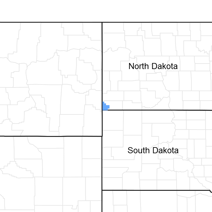
Figure 1. Mapped extent
Areas shown in blue indicate the maximum mapped extent of this ecological site. Other ecological sites likely occur within the highlighted areas. It is also possible for this ecological site to occur outside of highlighted areas if detailed soil survey has not been completed or recently updated.
MLRA notes
Major Land Resource Area (MLRA): 058D–Northern Rolling High Plains, Eastern Part
The Northern Rolling High Plains, Eastern Part (MLRA 58D) is shared between South Dakota (65 percent), Montana (21 percent), and North Dakota (14 percent). The MLRA is approximately 2,755 square miles. The small towns of Buffalo and Camp Crook, South Dakota, and Marmarth, North Dakota, are all within the boundary of this MLRA, and Baker, Montana, is on the northern most edge. Portions of the Little Missouri National Grassland and Custer National Forest are also in the MLRA. Portions of the Little Missouri River and the headwaters of major tributaries that eventually form the Grand and Moreau Rivers in South Dakota are also in this area.
The Northern Rolling High Plains, Eastern Part consists of Cretaceous marine and continental sediments of shale, siltstone, and sandstone. The continental and marine Hell Creek Formation is under approximately 85 percent of the MLRA, and the Fox Hills Sandstone forms the southern boundary of the MLRA. Tertiary deposits are in scattered areas throughout the MLRA. These deposits consist of the Paleocene Ludlow and Tongue River Formations, the Oligocene White River Group, and the Miocene Arikaree Group. These Tertiary deposits are resistant and positioned above the Cretaceous beds. Ponderosa pine growing in areas of these Tertiary formations further distinguishes these formations from the other formations in the MLRA. Pleistocene and Holocene river sand and gravel deposits are also on the valley floors and on the terraces along the larger rivers in the area. A large Quaternary eolian deposit is directly south of the town of Buffalo.
The average elevation of MLRA 58D ranges from 2,300 feet to 4,000 feet, increasing gradually from east to west. Harding Peak is the highest point at 4,019 feet. In places, flat-topped, steep-sided buttes rise sharply above the gently rolling plains below.
The dominant soil orders in this MLRA are Alfisols, Entisols, Inceptisols, and Mollisols. The soils in the area dominantly have a frigid soil temperature regime, an ustic soil moisture regime that borders on aridic, and mixed mineralogy. They are shallow to very deep, generally well drained, and loamy or clayey.
Annual precipitation is 14 to 17 inches and can fluctuate widely from year to year. Most rainfall occurs early in the growing season. Some high-intensity thunderstorms occur mid to late summer. The native vegetation in this MLRA consists primarily of grasses and forbs with a small component of trees and shrubs along streams. Ponderosa pine grow on the upper slopes and on the top of some of the higher buttes. Open grasslands are characterized by western wheatgrass, green needlegrass, blue grama, and buffalograss. Wyoming big sagebrush grows on clayey soils in the western part of the MLRA.
More than four-fifths of the MLRA is privately owned ranches running cattle, sheep, or both. Less than 5 percent of the area is federally owned. The major resource concerns are water quality, wind erosion, and water erosion (USDA, NRCS. 2006. Ag Handbook 296).
Classification relationships
USDA
Land Resource Region G—Western Great Plains Range and Irrigated Region:
Major Land Resource Area (MLRA) 58D—Northern Rolling High Plains, Eastern Part.
US Environmental Protection Agency (EPA)
Level IV Ecoregions of the Conterminous United States:
Northwestern Great Plains—43:
Forested Buttes—43d.
Sagebrush Steppe—43e.
USDA Forest Service
Ecological Subregions: Sections and Subsections of Conterminous United States:
Great Plains - Palouse Dry Steppe Province—331:
Missouri Plateau Section—331M.
Sagebrush Steppe Subsection—334Mi.
Ecological site concept
The Closed Depression ecological site occurs throughout MLRA 58D. It is a level to nearly level depression located on upland landscapes. The soils are silty clay to clay textured that formed from in clayey alluvium. They are poorly drained and have a very slow infiltration rate. The site will pond water during wet years, or after snow melt in the spring, and in heavy rain events during the early summer.
Depending on precipitation cycles, the vegetation can range from nearly pure stands of western wheatgrass when dry to spikerush, sedges, and wet land adapted forbs when wet.
Associated sites
| R058DY010SD |
Loamy The Loamy ecological site is found adjacent to the Closed Depression ecological site. |
|---|---|
| R058DY011SD |
Clayey The Clayey ecological site is found adjacent to the Closed Depression ecological site. |
Similar sites
| R058DY011SD |
Clayey The Clayey ecological site will have fewer grass-like species and less vegetative production than the Closed Depression ecological site. |
|---|---|
| R058DY010SD |
Loamy The Loamy ecological site will have fewer grass-like species and less vegetative production than the Closed Depression ecological site. |
Table 1. Dominant plant species
| Tree |
Not specified |
|---|---|
| Shrub |
Not specified |
| Herbaceous |
(1) Pascopyrum smithii |
Physiographic features
The Closed Depression ecological site is on concave to nearly level depressions on upland landscapes.
Table 2. Representative physiographic features
| Landforms |
(1)
Upland
> Depression
|
|---|---|
| Runoff class | Negligible |
| Flooding frequency | None |
| Ponding duration | Brief (2 to 7 days) to long (7 to 30 days) |
| Ponding frequency | Rare to occasional |
| Elevation | 2,300 – 4,000 ft |
| Slope | 2% |
| Ponding depth | 18 in |
| Water table depth | 80 in |
| Aspect | Aspect is not a significant factor |
Climatic features
The climate in MLRA 58D is typical of the drier portions of the Northern Great Plains where sagebrush steppes to the west yield to grassland to the east. Average annual precipitation ranges from 14 to 17 inches with most falling in the early growing season. Some high intensity, convective thunderstorms occur in the summer. Precipitation in winter occurs as snow. Temperatures show a wide range between summer and winter and between daily maximums and minimums. This wide range is due to the high elevation and dry air, which permit rapid incoming and outgoing radiation. Outbreaks of cold air from Canada in winter move rapidly from northwest to southeast and account for extreme minimum temperatures. Extreme storms may occur during the winter but have the most severe effect on ranching operations during late winter and in spring.
The normal average annual temperature is about 44 °F. January is the coldest month with average temperatures ranging from about 12 °F (Marmarth, North Dakota) to about 20 °F (Baker, Montana). July is the warmest month with temperatures averaging from about 70 °F (Marmarth, North Dakota) to about 76 °F (Baker, Montana). The range of normal average monthly temperatures between the coldest and warmest months is about 55 °F. Wind speeds are estimated to average about 11 miles per hour (mph) annually, ranging from about 13 mph during the spring to about 10 mph during the summer. Daytime winds are generally stronger than nighttime winds. Strong storms may bring brief periods of high winds with gusts of more than 50 mph.
Growth of cool-season plants begins in early to mid-March, slowing or ceasing in late June. Warm-season plants begin growth about mid-May and continue to early or mid-September. Cool-season plants may green-up in September and October if adequate soil moisture is present.
Table 3. Representative climatic features
| Frost-free period (characteristic range) | 97-111 days |
|---|---|
| Freeze-free period (characteristic range) | 121-129 days |
| Precipitation total (characteristic range) | 15-17 in |
| Frost-free period (actual range) | 93-115 days |
| Freeze-free period (actual range) | 120-132 days |
| Precipitation total (actual range) | 14-17 in |
| Frost-free period (average) | 104 days |
| Freeze-free period (average) | 125 days |
| Precipitation total (average) | 16 in |
Figure 2. Monthly precipitation range
Figure 3. Monthly minimum temperature range
Figure 4. Monthly maximum temperature range
Figure 5. Monthly average minimum and maximum temperature
Figure 6. Annual precipitation pattern
Figure 7. Annual average temperature pattern
Climate stations used
-
(1) BAKER 1 E [USC00240412], Baker, MT
-
(2) LADNER 9SW [USC00394671], Camp Crook, SD
-
(3) CAMP CROOK [USC00391294], Camp Crook, SD
-
(4) BUFFALO ASOS [USW00094037], Buffalo, SD
-
(5) BUFFALO 13 ESE [USW00094081], Reva, SD
-
(6) REDIG 11 NE [USC00397062], Buffalo, SD
-
(7) HOOVER [USC00393945], Newell, SD
Influencing water features
The Closed Depression received runoff from surrounding uplands and is ponded for several days or weeks during wet years or following snow melt in the spring and heavy rains through the mid-summer months.
Wetland description
System: Palustrine
Subsystem: N/A
Class: Emergent Wetland
Cowardin, et al., 1979
Soil features
Soils common to the Closed Depression ecological site have a silt clay to clay textured surface layer that is 2 to 3 inches thick. The soils are deep and formed in clayey alluvium derived from sedimentary rock. Slopes ranging from 0 to 2 percent. Soils are poorly drained and have a very slow infiltration rate.
This site should show slight to no evidence of rills or wind-scoured areas. Water flow paths are indistinguishable.
Major Soil correlated to the Closed Depression ecological site include, Heil and McKenzie
These soils are mainly susceptible to soil compaction. Heil will typically have a natric horizon. McKenzie is typically non-saline.
More information can be found in the various soil survey reports. Contact the local USDA Service Center for soil survey reports that include more detail specific to your area of interest, or use the internet to access USDA’s Web Soil Survey.
Table 4. Representative soil features
| Parent material |
(1)
Alluvium
|
|---|---|
| Surface texture |
(1) Silty clay (2) Clay |
| Family particle size |
(1) Clayey |
| Drainage class | Poorly drained |
| Permeability class | Very slow |
| Soil depth | 80 in |
| Surface fragment cover <=3" | Not specified |
| Surface fragment cover >3" | Not specified |
| Available water capacity (0-40in) |
6 in |
| Calcium carbonate equivalent (0-40in) |
15% |
| Electrical conductivity (0-40in) |
16 mmhos/cm |
| Sodium adsorption ratio (0-40in) |
4 |
| Soil reaction (1:1 water) (0-40in) |
5.6 – 9 |
| Subsurface fragment volume <=3" (Depth not specified) |
Not specified |
| Subsurface fragment volume >3" (Depth not specified) |
Not specified |
Ecological dynamics
The Closed Depression ecological site developed under the Northern Great Plains climatic conditions; light to severe grazing by bison and other large herbivores; sporadic, natural or human-caused wildfire (often of light intensities); and other biotic and abiotic factors that typically influence soil and site development. Changes occur in the plant communities due to short-term weather variations, effects of native and exotic plant and animal species, and management actions. Although the following plant community descriptions are typical of the transitions between communities, severe disturbances, such as periods of well below average precipitation and the introduction of non-native cool-season grasses, can cause significant shifts in plant communities and species composition.
This site is very sensitive to precipitation fluctuations from year to year. With above average precipitation, the site becomes very wet, leading to a much different plant community than what would be present with average to below average precipitation. In dry years, plant density becomes very low. The two sub-phases in this plant community are influenced strongly by precipitation and ponding of alone. During dry cycles, Western Wheatgrass is the dominate species; during wet cycles grass-likes species and forbs will be the dominate species. This vegetative shift makes up the natural fluctuation of what could be considered the Reference Plant Community (1.1).
The plant community upon which interpretations are primarily based is the Western Wheatgrass/Grass-likes/Forbs Plant Community (1.1). This plant community has been determined by studying rangeland relic areas, areas protected from excessive disturbance, and areas under long-term rotational grazing regimes. Trends in plant community dynamics ranging from heavily grazed to lightly grazed areas, seasonal use pastures, and historical accounts also have been used. Plant communities, states, transitional pathways, and thresholds have been determined through similar studies and experience.
The following state-and-transition diagram illustrates the common plant communities on the site and the transition pathways between communities. The ecological processes are discussed in more detail in the plant community descriptions following the diagram.
State and transition model
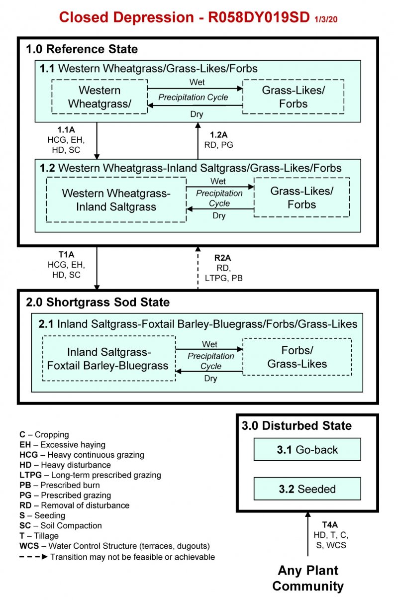
More interactive model formats are also available.
View Interactive Models
Click on state and transition labels to scroll to the respective text
Ecosystem states
State 1 submodel, plant communities
State 2 submodel, plant communities
State 3 submodel, plant communities
State 1
Reference State
The Reference State (1.0) represents what is believed to show the natural range of variability that dominated the dynamics of the ecological site prior to European settlement. This state is co-dominated by cool- and warm-season grasses, grass-likes, and forbs. In pre-European times, the primary disturbance mechanisms for this site in the Reference condition included an annual precipitation cycle resulting in alternating periods of ponding and drying, and as a seasonal watering and grazing resource for large herding ungulates. Timing of grazing coupled with weather events dictated the dynamics that occurred within the natural range of variability. Today, this state can be found on areas that are properly managed with grazing and possibly prescribed burning, and sometimes on areas receiving occasional short periods of rest. Western wheatgrass can decline and a corresponding increase in foxtail barley, warm-season shortgrasses, and forbs will occur. Under extended periods of disturbance, the main change is a reduction in vigor and production of the vegetation and an increase in bare ground and forb composition. The Reference State (1.0) has two plant communities with two distinct sub-phases as a result of the alternating periods of ponding and drying.
Dominant plant species
-
western wheatgrass (Pascopyrum smithii), grass
-
Nuttall's alkaligrass (Puccinellia nuttalliana), grass
-
slender wheatgrass (Elymus trachycaulus), grass
-
saltgrass (Distichlis spicata), grass
-
bluegrass (Poa), grass
-
rough bentgrass (Agrostis scabra), grass
-
common spikerush (Eleocharis palustris), grass
-
needle spikerush (Eleocharis acicularis), grass
-
rush (Juncus), grass
-
sedge (Carex), grass
-
smartweed (Polygonum kawagoeanum), other herbaceous
-
American licorice (Glycyrrhiza lepidota), other herbaceous
-
buttercup (Ranunculus), other herbaceous
-
evening primrose (Oenothera), other herbaceous
-
silver cinquefoil (Potentilla argentea), other herbaceous
-
slender cinquefoil (Potentilla gracilis), other herbaceous
-
western dock (Rumex aquaticus), other herbaceous
Community 1.1
Western Wheatgrass/Grass-Likes/Forbs
The interpretive plant community for this site is the Western Wheatgrass/Grass-Likes/Forbs Plant Community. This is also considered to be Reference Plant Community (1.1). The Reference Plant Community can be found on areas that are properly managed with grazing, possibly prescribed burning, and on areas receiving occasional short periods of deferment. Depending on annual precipitation and runoff into the close depression site, the dominant species can fluctuate significantly and express two somewhat distinct plant community sub-phases. The potential vegetation is about 40 to 90 percent grass and grass-like species, and 5 to 60 percent forbs. The significant grasses and grass-likes present include western wheatgrass, Nuttall’s alkaligrass, slender wheatgrass, inland saltgrass, bluegrass, ticklegrass, common spikerush, needle Spikerush, and other rushes and sedges. Significant forbs include smartweed, American licorice, buttercup, evening-primrose, silverleaf cinquefoil, slender cinquefoil, and western dock. This plant community is well adapted to the Northern Great Plains climatic conditions. Individual species can vary greatly in production depending on growing conditions (timing and amount of precipitation and temperature). Community dynamics, nutrient cycle, water cycle, and energy flow are functioning at this site’s potential. When present, plant litter is properly distributed with very little movement offsite. Natural plant mortality can be significant following periods of below average precipitation. The diversity in plant species allows for both the fluctuation of ponding as well as the occurrence of randomly occurring drought. The following describes the transitional plant community sub-phases that occur within the Reference Plant Community (1.1): Western Wheatgrass Phase: During the dry phase, the plant community will become dominated with perennial grasses such as western wheatgrass. Other grasses and grass-likes present include Nuttall’s alkaligrass, sedge, rush, bulrush, slender wheatgrass. The occurrence of forbs will be considerably lower, including some species such as American licorice, bluebells, seepweed, and western dock. The plant community is made up of about 90 percent grasses and grass-likes, and about 10 percent forbs. The total annual production (air-dry weight) of this plant community is typically about 3,500 lbs./acre. Grass-likes/Forbs Phase: During the wetter phase, the plant community will become dominated with grasses and grass-likes including sedge, bulrush, spikerush, rush, foxtail barley, ticklegrass, western wheatgrass, and bluegrasses. The forbs commonly found include western dock, mint, Pursh seepweed, lambsquarters, knotweed, evening-primrose, buttercup, and American licorice. The plant community is made up of about 10 percent grasses, 40 percent grass-likes, and about 50 percent forbs. The total annual production (air-dry weight) is about 2,500 lbs./acre.
Figure 8. Annual production by plant type (representative values) or group (midpoint values)
Table 5. Annual production by plant type
| Plant type | Low (lb/acre) |
Representative value (lb/acre) |
High (lb/acre) |
|---|---|---|---|
| Grass/Grasslike | 1300 | 1485 | 2200 |
| Forb | 100 | 715 | 1800 |
| Total | 1400 | 2200 | 4000 |
Figure 9. Plant community growth curve (percent production by month). SD5808, Northern Rolling High Plains, lowland cool-season/warm-season codominant. Cool-season, Warm-season codominant, Lowland.
| Jan | Feb | Mar | Apr | May | Jun | Jul | Aug | Sep | Oct | Nov | Dec |
|---|---|---|---|---|---|---|---|---|---|---|---|
| J | F | M | A | M | J | J | A | S | O | N | D |
| 0 | 0 | 4 | 11 | 19 | 23 | 20 | 12 | 6 | 5 | 0 | 0 |
Community 1.2
Western Wheatgrass-Inland Saltgrass/Grass-Likes/Forbs
This plant community is the result of heavy disturbances including heavy continuous grazing, and in some cases, repeated seasonal grazing such as spring grazing every year; excessive haying; and potentially soil compaction. Lack of litter and short plant heights result in higher soil temperatures, high evaporation, and increased percolation of the high-water table, which increases salt concentrations on the surface. This gives inland saltgrass and other salt tolerant species a competitive advantage over less tolerant species. Western wheatgrass and inland saltgrass drastically increase and are the dominant species with the balance being a few species of cool-season grasses, and grass-likes including Nuttall’s alkaligrass, plains bluegrass, ticklegrass, common spikerush, needle spikerush, and other sedges and rushes. Early cool-season grasses including foxtail barley and bluegrass begin to increase and invade. Forbs that will invade are curly dock, sweetclover, and cocklebur. Lambsquarters, pepperweed, povertyweed, and western dock will increase in composition. This plant community is relatively stable and well adapted to increased salinity. Plant vigor, litter, frequency, and production have decreased. The biological integrity, water, and nutrient cycles of this plant community are becoming impaired. This plant community is less productive than the Reference Plant Community (1.1).
Figure 10. Annual production by plant type (representative values) or group (midpoint values)
Table 6. Annual production by plant type
| Plant type | Low (lb/acre) |
Representative value (lb/acre) |
High (lb/acre) |
|---|---|---|---|
| Grass/Grasslike | 1115 | 1305 | 1500 |
| Forb | 85 | 495 | 900 |
| Total | 1200 | 1800 | 2400 |
Figure 11. Plant community growth curve (percent production by month). SD5808, Northern Rolling High Plains, lowland cool-season/warm-season codominant. Cool-season, Warm-season codominant, Lowland.
| Jan | Feb | Mar | Apr | May | Jun | Jul | Aug | Sep | Oct | Nov | Dec |
|---|---|---|---|---|---|---|---|---|---|---|---|
| J | F | M | A | M | J | J | A | S | O | N | D |
| 0 | 0 | 4 | 11 | 19 | 23 | 20 | 12 | 6 | 5 | 0 | 0 |
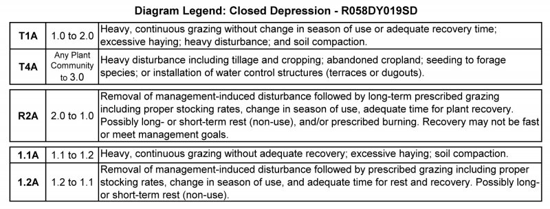
Pathway 1.1A
Community 1.1 to 1.2
Heavy continuous grazing (grazing at full to heavy levels for extended portions of the growing season without adequate recovery periods); excessive haying; or heavy disturbance can lead the Reference Plant Community (1.1) to the Western Wheatgrass-Inland Saltgrass/Grass-Likes/Forbs Plant Community (1.2). During the wet cycles prior to soils drying, the Reference Plant Community (1.1) is highly susceptible to compaction if heavy animal impacts occurs when the soil is saturated. There is a potential for the increase in sodium concentrations on the soil surface with heavy disturbance and increased evaporation.
Pathway 1.2A
Community 1.2 to 1.1
Removal of heavy disturbance combined with prescribed grazing that includes alternating season of use, allowing adequate recovery periods between grazing events, and possibly the use of prescribed burning, will shift this plant community back to the Reference Plant Community (1.1). Soil compaction and the increase in sodium in the surface layer may slow or inhibit this pathway.
Conservation practices
| Prescribed Burning | |
|---|---|
| Prescribed Grazing |
State 2
Shortgrass Sod State
The Shortgrass Sod State is dominated by inland saltgrass, foxtail barley, and bluegrass during the drier phase and forbs and grass-like species during the wet phase. This State is the result of heavy, continuous grazing and/or excessive haying, or heavy disturbance which can create soil compaction and increased sodium concentrations on the soil surface. This State, like the Reference State (1.0), will have one plant community (2.1) with two distinct sub-phases as a result of the alternating periods of ponding and drying. The Shortgrass Sod State (1.0) is very resilient and resistant to change.
Dominant plant species
-
saltgrass (Distichlis spicata), grass
-
foxtail barley (Hordeum jubatum), grass
-
bluegrass (Poa), grass
-
Nuttall's alkaligrass (Puccinellia nuttalliana), grass
-
western wheatgrass (Pascopyrum smithii), grass
Community 2.1
Inland Saltgrass-Foxtail Barley-Bluegrass/Forbs/Grass-Likes
This plant community developed with heavy continuous grazing where adequate recovery periods between grazing events were not allowed; excessive haying; or heavy disturbance. Patches of inland saltgrass sod are typical and foxtail barley and bluegrass is well distributed throughout the community. Nuttall’s alkaligrass and western wheatgrass have been greatly reduced in production and vigor and may persist in remnant amounts. This plant community is resistant to change due to the grazing tolerance of inland saltgrass and increased surface salts. A significant amount of production and diversity has been lost when compared to the Reference Plant Community (1.1). Loss of key cool-season grasses and increased bare ground have negatively impacted energy flow and nutrient cycling. Water infiltration is reduced significantly due to the massive shallow root system “root pan,” characteristic of inland saltgrass, and increased bare ground. It will take a long time to bring this plant community back to the Reference Plant Community (1.1) with management alone. Renovation (mechanical and/or chemical inputs) is not recommended due to high salt content of the soil and saltgrass persistence.
Figure 12. Annual production by plant type (representative values) or group (midpoint values)
Table 7. Annual production by plant type
| Plant type | Low (lb/acre) |
Representative value (lb/acre) |
High (lb/acre) |
|---|---|---|---|
| Grass/Grasslike | 465 | 600 | 700 |
| Forb | 35 | 200 | 400 |
| Total | 500 | 800 | 1100 |
Figure 13. Plant community growth curve (percent production by month). SD5807, Northern Rolling High Plains, cool-season dominant, warm-season subdominant. Cool-season dominant, Warm-season subdominant, Lowland.
| Jan | Feb | Mar | Apr | May | Jun | Jul | Aug | Sep | Oct | Nov | Dec |
|---|---|---|---|---|---|---|---|---|---|---|---|
| J | F | M | A | M | J | J | A | S | O | N | D |
| 0 | 0 | 5 | 13 | 20 | 25 | 18 | 11 | 5 | 3 | 0 | 0 |
State 3
Disturbed State
Any plant community can transition to the Disturbed State (3.0). The two separate vegetative plant communities found in this state are highly variable in nature. They are derived through different management scenarios and are not related successionally. Mechanical manipulation of the watershed causing the loss of hydrologic function, biotic integrity, and soil site stability. Hydrologic function of this site is disrupted through terracing, contour furrowing, or pitting in the area surrounding the closed depression, or the installation of a dugout in the closed depression site. Other causes include, severe mechanical disturbance through tillage and the conversion to cropland or pasture and hayland.
Dominant plant species
-
broom snakeweed (Gutierrezia sarothrae), shrub
-
bluegrass (Poa), grass
-
smooth brome (Bromus inermis), grass
-
field brome (Bromus arvensis), grass
-
crested wheatgrass (Agropyron cristatum), grass
-
sweetclover (Melilotus), other herbaceous
-
deathcamas (Zigadenus), other herbaceous
-
prickly lettuce (Lactuca serriola), other herbaceous
Community 3.1
Go-back
During the early successional stages, on Go-back lands (abandoned cropland), the species that dominate are annual grasses and forbs, later replaced by both native and introduced perennials. The vegetation on this site varies greatly, sometimes dominated by bluegrass, smooth bromegrass, annual brome, crested wheatgrass, broom snakeweed, sweetclover, and non-native thistles. Other plants that commonly occur on the site include western wheatgrass, deathcamas, prickly lettuce, horseweed, kochia, dock, and foxtail barley. Bare ground is prevalent due to the loss of organic matter and lower overall soil health. When runoff flowing into this site is eliminated though construction of water control structures such as terraces or dugouts, this site is likely to resemble the Claypan ecological site and have similar ecological dynamics.
Community 3.2
Seeded
The Seeded Plant Community normally includes those areas seeded to western wheatgrass, crested wheatgrass, alfalfa, or other forage species. For adapted species, refer to the USDA-NRCS e-FOTG for the appropriate Forage Suitability Group description.
Transition T1A
State 1 to 2
Heavy, continuous grazing (grazing at full to heavy levels for extended portions of the growing season without adequate recovery periods); or excessive haying; or heavy disturbance may cause a shift from the Reference State (1.0) to the Shortgrass Sod State (2.0). During the wet cycles prior to soils drying, the Reference Plant Community (1.1) is highly susceptible to compaction if heavy grazing occurs when the soil is saturated. This type of disturbance can cause a rapid decline in the native vegetation and a subsequent influx of non-native forb species to occur.
Transition T4A
State 1 to 3
Heavy disturbance including tillage and cropping; abandonment of cropland; seeding to improved pasture species; or installation of water control structures (terraces or dugouts) will transition any plant community in this ecological site to the Degraded State (3.0).
Restoration pathway R2A
State 2 to 1
Removal of the grazing disturbance coupled with long-term prescribed grazing including proper stocking rates, change in season of use, and adequate time for plant recovery following grazing event may shift the Shortgrass Sod State (2.0) to the Reference State (1.0). This transition may not be rapid or in the end meet management goals. Prescribed burning may also be a tool to aid in this transition.
Conservation practices
| Prescribed Burning | |
|---|---|
| Prescribed Grazing |
Transition T4A
State 2 to 3
Heavy disturbance including tillage and cropping; abandonment of cropland; seeding to improved pasture species; or installation of water control structures (terraces or dugouts) will transition any plant community in this ecological site to the Degraded State (3.0).
Additional community tables
Table 8. Community 1.1 plant community composition
| Group | Common name | Symbol | Scientific name | Annual production (lb/acre) | Foliar cover (%) | |
|---|---|---|---|---|---|---|
|
Grass/Grasslike
|
||||||
| 1 | Rhizomatous Wheatgrasses | 330–1320 | ||||
| western wheatgrass | PASM | Pascopyrum smithii | 110–1320 | – | ||
| thickspike wheatgrass | ELLAL | Elymus lanceolatus ssp. lanceolatus | 0–660 | – | ||
| 2 | Cool-Season Bunchgrass | 100–660 | ||||
| Nuttall's alkaligrass | PUNU2 | Puccinellia nuttalliana | 22–440 | – | ||
| foxtail barley | HOJU | Hordeum jubatum | 0–330 | – | ||
| 3 | Short Warm-Season Grasses | 22–220 | ||||
| saltgrass | DISP | Distichlis spicata | 22–220 | – | ||
| buffalograss | BODA2 | Bouteloua dactyloides | 0–44 | – | ||
| 4 | Other Native Grasses | 44–220 | ||||
| fowl bluegrass | POPA2 | Poa palustris | 22–220 | – | ||
| scratchgrass | MUAS | Muhlenbergia asperifolia | 22–220 | – | ||
| Grass, perennial | 2GP | Grass, perennial | 0–220 | – | ||
| plains bluegrass | POAR3 | Poa arida | 0–176 | – | ||
| slender wheatgrass | ELTR7 | Elymus trachycaulus | 0–110 | – | ||
| American sloughgrass | BESY | Beckmannia syzigachne | 0–110 | – | ||
| rough bentgrass | AGSC5 | Agrostis scabra | 0–110 | – | ||
| 5 | Grass-Likes | 110–660 | ||||
| common spikerush | ELPA3 | Eleocharis palustris | 110–550 | – | ||
| needle spikerush | ELAC | Eleocharis acicularis | 110–550 | – | ||
| Grass-like (not a true grass) | 2GL | Grass-like (not a true grass) | 0–330 | – | ||
| sedge | CAREX | Carex | 110–330 | – | ||
| rush | JUNCU | Juncus | 22–220 | – | ||
| 6 | Non-Native Cool-Season Grasses | 0 | ||||
|
Forb
|
||||||
| 7 | Forbs | 110–1320 | ||||
| lambsquarters | CHAL7 | Chenopodium album | 0–440 | – | ||
| knotweed | POLYG4 | Polygonum | 0–440 | – | ||
| Forb, perennial | 2FP | Forb, perennial | 0–440 | – | ||
| western dock | RUAQ | Rumex aquaticus | 0–330 | – | ||
| wild mint | MEAR4 | Mentha arvensis | 0–330 | – | ||
| Pursh seepweed | SUCA2 | Suaeda calceoliformis | 0–330 | – | ||
| buttercup | RANUN | Ranunculus | 0–330 | – | ||
| evening primrose | OENOT | Oenothera | 0–330 | – | ||
| American licorice | GLLE3 | Glycyrrhiza lepidota | 0–330 | – | ||
| povertyweed | IVAX | Iva axillaris | 0–220 | – | ||
| prairie ironweed | VEFA2 | Vernonia fasciculata | 0–220 | – | ||
| silver cinquefoil | POAR8 | Potentilla argentea | 0–220 | – | ||
| redwool plantain | PLER | Plantago eriopoda | 0–220 | – | ||
| slender cinquefoil | POGRF2 | Potentilla gracilis var. fastigiata | 0–110 | – | ||
| mountain deathcamas | ZIEL2 | Zigadenus elegans | 0–110 | – | ||
| bluebells | MERTE | Mertensia | 0–110 | – | ||
| pepperweed | LEPID | Lepidium | 0–110 | – | ||
Table 9. Community 1.2 plant community composition
| Group | Common name | Symbol | Scientific name | Annual production (lb/acre) | Foliar cover (%) | |
|---|---|---|---|---|---|---|
|
Grass/Grasslike
|
||||||
| 1 | Rhizomatous Wheatgrasses | 720–1080 | ||||
| western wheatgrass | PASM | Pascopyrum smithii | 720–1080 | – | ||
| thickspike wheatgrass | ELLAL | Elymus lanceolatus ssp. lanceolatus | 180–540 | – | ||
| 2 | Cool-Season Bunchgrass | 90–360 | ||||
| foxtail barley | HOJU | Hordeum jubatum | 54–180 | – | ||
| Nuttall's alkaligrass | PUNU2 | Puccinellia nuttalliana | 90–180 | – | ||
| 3 | Short Warm-Season Grasses | 18–270 | ||||
| saltgrass | DISP | Distichlis spicata | 360–720 | – | ||
| buffalograss | BODA2 | Bouteloua dactyloides | 0–90 | – | ||
| 4 | Other Native Grasses | 18–90 | ||||
| fowl bluegrass | POPA2 | Poa palustris | 18–108 | – | ||
| plains bluegrass | POAR3 | Poa arida | 0–90 | – | ||
| slender wheatgrass | ELTR7 | Elymus trachycaulus | 0–90 | – | ||
| American sloughgrass | BESY | Beckmannia syzigachne | 0–90 | – | ||
| scratchgrass | MUAS | Muhlenbergia asperifolia | 0–90 | – | ||
| rough bentgrass | AGSC5 | Agrostis scabra | 0–90 | – | ||
| Grass, perennial | 2GP | Grass, perennial | 0–90 | – | ||
| 5 | Grass-Likes | 90–540 | ||||
| sedge | CAREX | Carex | 90–270 | – | ||
| common spikerush | ELPA3 | Eleocharis palustris | 36–180 | – | ||
| Grass-like (not a true grass) | 2GL | Grass-like (not a true grass) | 0–180 | – | ||
| rush | JUNCU | Juncus | 36–180 | – | ||
| needle spikerush | ELAC | Eleocharis acicularis | 0–90 | – | ||
| 6 | Non-Native Cool-Season Grasses | 0–90 | ||||
| Kentucky bluegrass | POPR | Poa pratensis | 0–90 | – | ||
| cheatgrass | BRTE | Bromus tectorum | 0–90 | – | ||
| field brome | BRAR5 | Bromus arvensis | 0–90 | – | ||
|
Forb
|
||||||
| 7 | Forbs | 90–900 | ||||
| mountain deathcamas | ZIEL2 | Zigadenus elegans | 0–180 | – | ||
| lambsquarters | CHAL7 | Chenopodium album | 0–180 | – | ||
| cocklebur | XANTH2 | Xanthium | 0–90 | – | ||
| slender cinquefoil | POGRF2 | Potentilla gracilis var. fastigiata | 0–90 | – | ||
| knotweed | POLYG4 | Polygonum | 0–90 | – | ||
| sweetclover | MELIL | Melilotus | 0–90 | – | ||
| Forb, perennial | 2FP | Forb, perennial | 0–90 | – | ||
| bluebells | MERTE | Mertensia | 0–90 | – | ||
| redwool plantain | PLER | Plantago eriopoda | 0–54 | – | ||
| American licorice | GLLE3 | Glycyrrhiza lepidota | 0–54 | – | ||
| western dock | RUAQ | Rumex aquaticus | 0–54 | – | ||
| curly dock | RUCR | Rumex crispus | 0–54 | – | ||
| curlycup gumweed | GRSQ | Grindelia squarrosa | 0–54 | – | ||
| evening primrose | OENOT | Oenothera | 0–54 | – | ||
| pepperweed | LEPID | Lepidium | 0–54 | – | ||
| prairie ironweed | VEFA2 | Vernonia fasciculata | 0–54 | – | ||
| Pursh seepweed | SUCA2 | Suaeda calceoliformis | 0–54 | – | ||
| Forb, introduced | 2FI | Forb, introduced | 0–36 | – | ||
| buttercup | RANUN | Ranunculus | 0–18 | – | ||
Table 10. Community 2.1 plant community composition
| Group | Common name | Symbol | Scientific name | Annual production (lb/acre) | Foliar cover (%) | |
|---|---|---|---|---|---|---|
|
Grass/Grasslike
|
||||||
| 1 | Rhizomatous Wheatgrass | 0–40 | ||||
| western wheatgrass | PASM | Pascopyrum smithii | 0–40 | – | ||
| 2 | Cool-Season Bunchgrass | 160–400 | ||||
| foxtail barley | HOJU | Hordeum jubatum | 240–480 | – | ||
| Nuttall's alkaligrass | PUNU2 | Puccinellia nuttalliana | 40–80 | – | ||
| 3 | Short Warm-Season Grasses | 8–200 | ||||
| saltgrass | DISP | Distichlis spicata | 80–240 | – | ||
| buffalograss | BODA2 | Bouteloua dactyloides | 0–8 | – | ||
| 4 | Other Native Grasses | 0–40 | ||||
| slender wheatgrass | ELTR7 | Elymus trachycaulus | 0–40 | – | ||
| American sloughgrass | BESY | Beckmannia syzigachne | 0–40 | – | ||
| scratchgrass | MUAS | Muhlenbergia asperifolia | 0–40 | – | ||
| rough bentgrass | AGSC5 | Agrostis scabra | 0–40 | – | ||
| Grass, perennial | 2GP | Grass, perennial | 0–40 | – | ||
| fowl bluegrass | POPA2 | Poa palustris | 0–32 | – | ||
| 5 | Grass-Likes | 16–160 | ||||
| sedge | CAREX | Carex | 40–120 | – | ||
| common spikerush | ELPA3 | Eleocharis palustris | 16–80 | – | ||
| needle spikerush | ELAC | Eleocharis acicularis | 0–80 | – | ||
| Grass-like (not a true grass) | 2GL | Grass-like (not a true grass) | 0–80 | – | ||
| rush | JUNCU | Juncus | 16–80 | – | ||
| 6 | Non-Native Cool-Season Grasses | 24–120 | ||||
| Kentucky bluegrass | POPR | Poa pratensis | 16–80 | – | ||
| cheatgrass | BRTE | Bromus tectorum | 0–80 | – | ||
| field brome | BRAR5 | Bromus arvensis | 0–80 | – | ||
|
Forb
|
||||||
| 7 | Forbs | 40–360 | ||||
| lambsquarters | CHAL7 | Chenopodium album | 0–120 | – | ||
| Forb, introduced | 2FI | Forb, introduced | 0–80 | – | ||
| curly dock | RUCR | Rumex crispus | 0–80 | – | ||
| curlycup gumweed | GRSQ | Grindelia squarrosa | 0–40 | – | ||
| cocklebur | XANTH2 | Xanthium | 0–40 | – | ||
| Forb, perennial | 2FP | Forb, perennial | 0–40 | – | ||
| western dock | RUAQ | Rumex aquaticus | 0–24 | – | ||
| mountain deathcamas | ZIEL2 | Zigadenus elegans | 0–24 | – | ||
| slender cinquefoil | POGRF2 | Potentilla gracilis var. fastigiata | 0–24 | – | ||
| knotweed | POLYG4 | Polygonum | 0–24 | – | ||
| bluebells | MERTE | Mertensia | 0–24 | – | ||
| pepperweed | LEPID | Lepidium | 0–16 | – | ||
| sweetclover | MELIL | Melilotus | 0–8 | – | ||
Interpretations
Animal community
Wildlife Interpretations
MLRA 58D lies within the drier portion of the northern mixed-grass prairie ecosystem where sagebrush steppes to the west yield to grassland steppes to the east. Prior to European settlement, this area consisted of diverse grass- and shrubland habitats interspersed with varying densities of depressional instream wetlands and woody riparian corridors. These habitats provided critical life cycle components for many users. Many species of grassland birds, small mammals, reptiles, amphibians, and herds of roaming bison, elk, and pronghorn were among the inhabitants adapted to this semi-arid region. Roaming herbivores, as well as several small mammal and insect species, were the primary consumers linking the grassland resources to predators such as the gray wolf, mountain lion, and grizzly bear, and smaller carnivores such as the coyote, bobcat, fox, and raptors. The prairie dog was once abundant; however, the species remains a keystone species within its range. The black-footed ferret, burrowing owl, ferruginous hawk, mountain plover, and swift fox were associated with prairie dog complexes.
Historically, the northern mixed-grass prairie was a disturbance-driven ecosystem with fire, herbivory, and climate functioning as the primary disturbance factors either singly or in combination. Following European settlement, livestock grazing, cropland conversion, elimination of fire, energy development, and other anthropogenic factors influenced species composition and abundance. Introduced and invasive species further impacted plant and animal communities. The bison was a historical keystone species but had been extirpated in this area as a free-ranging herbivore. The loss of the bison and reduction of prairie dog populations and fire as ecological drivers greatly influenced the character of the remaining native plant communities and altered wildlife habitats. Human development has reduced habitat quality for area-sensitive species.
Within MLRA 58D, the Closed Depression ecological site provides upland grassland cover with an associated forb component. It was typically part of an expansive grassland landscape that included combinations of Shallow Loamy, Shallow Clayey, Thin Loamy, Thin Claypan, Sandy, Sandy Claypan, Loamy, Loamy Terrace, Sandy Terrace, and Clayey ecological sites.
This site provided habitat for species requiring unfragmented grassland. Important habitat features, and components found commonly or exclusively on this site may include sharp-tailed grouse leks; upland nesting habitat for grassland birds, forbs and insects for brood habitat; and a forage source for small and large herbivores. Many grassland and shrub steppe nesting bird populations are declining. Extirpated species include free-ranging American bison, grizzly bear, gray wolf, black-footed ferret, mountain plover, Rocky Mountain locust, and swift fox.
The Closed Depression ES has remained relatively intact but may be subject to haying under drier conditions. This site has sufficient hydrology to support hydrophytic vegetation and wildlife species associated with ponded and saturated soil conditions. This site receives surface water from adjacent upland sites, snow melt, and rainfall events. The site provides important wetland habitat for birds, small rodents, bats, mammalian predators, reptiles, and insects. These sites also provide forage sites for greater sage-grouse broods.
Western Wheatgrass/Grass-Likes/Forbs (1.1): The Closed Depression ecological site fluctuates between two separate sub-phases of the Reference Plant Community (1.1) depending upon the precipitation cycle. During drier cycles, the site is dominated by western wheatgrass. During wetter cycles the site is dominated by grass-like plants (e.g., sedges and rushes) and forbs.
During drier cycles, the western wheatgrass dominated site provides upland wildlife habitat. Mixed-grass species and species associated with the adjacent ecological sites will utilize this site.
During wetter cycles, the sedge, rush, and forb site provides wetland wildlife habitat.
The predominance of hydrophytic vegetation, including a high diversity of sedges and other grass-like species, favors shorebirds (e.g., plovers, sandpipers, and snipe) and wetland associated songbirds. This plant community provides habitat for salamanders, various frog and toad species, and various snake species. Invertebrates are an important component of the food web. Raptors such as northern harrier, short-eared owl, Swainson’s hawk, and American kestrel, will use this site. Prey populations are limited to small mammals such as water shrew and meadow vole and invertebrates. When associated with ecological sites dominated by Wyoming big sagebrush, greater sage-grouse will use the site for brood rearing and foraging habitat.
Inland Saltgrass-Foxtail Barley-Bluegrass/Forbs/Grass-Likes (2.1): Resulting from heavy continuous grazing, this site becomes dominated by shorter more saline tolerant species. The predominance of saline tolerant hydrophytic vegetation does not favor any particular wildlife group. However, the site may receive limited shorebird use. This plant community provides habitat for limited invertebrate populations. Herptile use is either extremely limited or nonexistent. Raptors such as northern harrier, short-eared owl, Swainson’s hawk, and American kestrel will use this site. Prey populations are limited to small mammals such as water shrew and meadow vole and invertebrates.
Grazing Interpretations
The following list suggests annual, initial stocking rates for average growing conditions. These estimates are conservative and should be used only as guidelines in the initial stages of conservation planning. Commonly, the current plant composition does not entirely match any particular plant community (as described in this ecological site description). Therefore, a resource inventory is necessary to document plant composition and production. More accurate estimates of carrying capacity should eventually be calculated using the following stocking rate information along with animal preference data and actual stocking records, particularly when grazers other than cattle are involved. In consultation with the land manager, a more intensive grazing management program that results in improved harvest efficiencies and increased carrying capacity may be developed.
The following suggested initial stocking rates are based on 912 lb/acre (air-dry weight) per animal-unit-month (AUM) with a 25 percent harvest efficiency of preferred and desirable forage species (refer to USDA-NRCS, National Range and Pasture Handbook). An AUM is defined as the equivalent amount of forage required by a 1,000-pound cow, with or without calf, for one month.
Plant Community: Western Wheatgrass/Grass-Likes/Forbs (1.1)
Average Production (lb/acre, air-dry): 2,200
Stocking Rate (AUM/acre): 0.60
Plant Community: Western Wheatgrass-Inland Saltgrass/Grass-Likes/Forbs (1.2)
Average Production (lb/acre, air-dry): 1,800
Stocking Rate (AUM/acre): 0.49
Plant Community: All other plant communities identified in this document have variable annual production values and require onsite sampling to determine initial stocking rates.
* Total annual production and stocking rates are highly variable and require onsite sampling.
Total onsite annual production may contain vegetation deemed undesirable or untargeted by the grazing animal. Therefore, AUM values may need to be reduced to reflect only preferred or desirable forage species.
Grazing by domestic livestock is one of the major income-producing industries in the area. Rangeland in this area may provide yearlong forage for livestock. During the dormant period, the forage for livestock likely has insufficient protein to meet livestock requirements. Added protein allows ruminants to better utilize the energy stored in grazed plant materials. A forage quality test (either directly or through fecal sampling) should be used to determine the level of supplementation needed.
Hydrological functions
Water is the principal factor limiting forage production on this site. This site is dominated by soils in hydrologic group D. Infiltration and runoff potential for this site varies from moderate to high depending on soil hydrologic group, slope, and ground cover. In many cases, areas with greater than 75 percent ground cover have the greatest potential for high infiltration and lower runoff. An example of an exception would be where shortgrasses form a strong sod and dominate the site. Normally areas where ground cover is less than 50 percent have the greatest potential to have reduced infiltration and higher runoff. Refer to the USDA-NRCS National Engineering Handbook, Part 630, for hydrologic soil groups, runoff quantities, and hydrologic curves.
Recreational uses
This site provides opportunities for hunting upland game species. The wide variety of plants that bloom from spring until fall have aesthetic value that appeals to visitors.
Wood products
No appreciable wood products are typically present on this site.
Other products
Harvesting the seeds of native plants can provide additional income on this site.
Other information
Revision Notes: “Previously Approved” Provisional
This provisional ecological site description (ESD) has passed quality control (QC) and quality assurance (QA) to ensure it meets the 2014 NESH standards for a “Provisional” ecological site description.
This ecological site description (ESD) is an updated “Previously Approved” ESD that represented a first-generation tier of documentation that met all requirements as an “Approved” ESD as laid out in the 1997 National Range and Pasture Handbook (NRPH). The requirements for approved status changed with the release of the 2014 National Ecological Site Handbook (NESH). The previously approved document fully described the reference state and community phases in the state-and-transition model. All other alternative states were at least described in narrative form. The “Previously Approved” ESD has been field-tested for a minimum of five years and is a proven functional document for conservation planning. The “Previously Approved” ESD may not contain all tabular and narrative entries as required in the current “Approved” level of documentation, but it is expected this ESD will continue refinement toward the current “Approved” status.
Site Development and Testing Plan
Future work, as described in an official project plan, is necessary to validate the information in this provisional ecological site description. The plan will include field activities for low-, medium-, and high-intensity sampling, soil correlations, and analysis of the data. Annual field reviews should be done by soil scientists and vegetation specialists. Final field review, peer review, quality control, and quality assurance reviews are required to produce the final document.
Supporting information
Inventory data references
Information presented here has been derived from NRCS clipping data and other inventory data. Field observations from range-trained personnel were also used. Those involved in developing this site description include: Ryan Beer, Range Management Specialist (RMS), NRCS; Chuck Berdan, Biologist, Bureau of Land Management (BLM); Stan Boltz, RMS, NRCS; Dave Dewald, Wildlife BIO, NRCS; Mitch Faulkner, RMS, NRCS; Jody Forman, RMS, NRCS; Dennis Froemke, RMS, NRCS; Tom Juntti, BIO, United States Forest Service (USFS); Cheryl Nielsen, RMS, NRCS; Jeff Printz, RMS, NRCS; Mike Stirling, RMS, NRCS; Dan Svingen, BIO, USFS; Darrell Vanderbusch, Soil Scientist, NRCS; Cindy Zachmeier, BIO, NRCS; and Tim Zachmeier, BIO, BLM.
Other references
Beck, J.L., J.W. Connelly, C.L. Wambolt. 2010. Consequences of treating Wyoming big sagebrush to enhance wildlife habitats; Rangeland Ecology and Management 65:444–455, September 2012
Cleland, D.T., J.A. Freeouf, J.E. Keys, G.J. Nowacki, C.A. Carpenter, and W.H McNab. 2007. Ecological subregions: Sections and subsections of the conterminous United States. USDA Forest Service, General Technical Report WO-76D. https://www.fs.fed.us/research/publications/misc/73326-wo-gtr-76d-cleland2007.pdf (accessed 31 January 2019).
Cooper, S.V., P. Lesica, G.M. Kudray. 2001. Post-fire recovery of Wyoming big sagebrush steppe in central and southeastern Montana; Natural Resources and Environmental Issues, Volume 16; Shrublands: Wildlands and Wildlife Habitats, Article 12.
Cowardin, L.M., V. Carter, F.C. Golet, and E.T. LaRoe. 1979. Classification of wetlands and deep-water habitats of the United States. U.S. Fish and Wildlife Service FWS/OBS-79/31.
High Plains Regional Climate Center, University of Nebraska. 2018. http://www.hprcc.unl.edu/ (accessed 6 April 2018).
Innes, Robin J. 2019. Artemisia tridentata subsp. wyomingensis, Wyoming big sagebrush. In: Fire Effects Information System, [Online]. U.S. Department of Agriculture, Forest Service, Rocky Mountain Research Station, Missoula Fire Sciences Laboratory (Producer). Available: https://www.fs.fed.us/database/feis/plants/shrub/arttriw/all.html (accessed 9 December 2019).
Larson, G.E. and J.R. Johnson. 1999. Plants of the Black Hills and Bear Lodge Mountains. South Dakota State University, College of Agriculture and Biological Sciences and Agriculture Experiment Station, Bulletin 732, Brookings, SD.
Toledo, D., M. Sanderson, K. Spaeth, J. Hendrickson, and J. Printz. 2014. Extent of Kentucky bluegrass and its effect on native plant species diversity and ecosystem services in the Northern Great Plains of the United States. Invasive Plant Science and Management. 7(4):543–522. Weed Science Society of America.
Soil Survey Staff. 2019. Official soil series descriptions. USDA Natural Resources Conservation Service. https://www.nrcs.usda.gov/wps/portal/nrcs/detail/soils/home/?cid=nrcs142p2_053587 (accessed 17 December 2019).
Soil Survey Staff. 2019. Web Soil Survey. USDA Natural Resources Conservation Service. https://websoilsurvey.sc.egov.usda.gov/App/WebSoilSurvey.aspx (accessed 17 December 2019).
U.S. Department of Agriculture, Natural Resources Conservation Service. 1997. National range and pasture handbook, rev. 1, 2003. https://www.nrcs.usda.gov/Internet/FSE_DOCUMENTS/stelprdb1043055.pdf (accessed 7 January 2018).
U.S. Department of Agriculture, Natural Resources Conservation Service. 2006. Land resource regions and major land resource areas of the United States, the Caribbean, and the Pacific Basin. Agriculture Handbook 296. https://www.nrcs.usda.gov/Internet/FSE_DOCUMENTS/nrcs142p2_050898.pdf (accessed 17 January 2018).
U.S. Department of Agriculture, Natural Resources Conservation Service. 2012. National engineering handbook, part 630. Hydrology chapters from e-Directives. https://directives.sc.egov.usda.gov/viewerFS.aspx?hid=21422 (accessed 17 January 2018).
U.S. Department of Agriculture, Natural Resources Conservation Service. 2014. National ecological site handbook, 1st ed. https://www.nrcs.usda.gov/wps/portal/nrcs/detail/soils/ref/?cid=nrcseprd1291232 (accessed 27 January 2018).
U.S. Department of Agriculture, Natural Resources Conservation Service. 2018. Climate data. National Water and Climate Center. http://www.wcc.nrcs.usda.gov/ (accessed 2 December 2018).
U.S. Department of Agriculture, Natural Resources Conservation Service. 2019. Electronic field office technical guide. https://efotg.sc.egov.usda.gov (accessed 11 December 2019).
U.S. Department of Agriculture, Natural Resources Conservation Service. 2018. National Soil Information System, Information Technology Center. http://nasis.nrcs.usda.gov (accessed 25 May 2018.
U.S. Department of Agriculture, Natural Resources Conservation Service. 2019. PLANTS database. National Plant Data Team, Greensboro, NC. http://plants.usda.gov (accessed 11 December 2019).
U.S. Environmental Protection Agency. 2018. EPA level III and level IV ecoregions of the conterminous United States. https://www.epa.gov/eco-research/level-iii-and-iv-ecoregions- conterminous-united-states (accessed 26 April 2018).
Contributors
Stan c. Boltz
Travis Patient
Rick L. Peterson
Approval
Suzanne Mayne-Kinney, 7/18/2024
Acknowledgments
This ecological site description was updated by Rick L. Peterson on January 3, 2020.
The ESDs were available for QC review by Mark Hayek, Emily Helms, Ryan Beer, and Mitch Faulkner.
All ecological sites were then reviewed and approved at the Provisional Level by David Kraft, Regional ESS, Salina, KS in September 2020.
Non-Discrimination Statement
In accordance with Federal civil rights law and U.S. Department of Agriculture (USDA) civil rights regulations and policies, the USDA, its Agencies, offices, and employees, and institutions participating in or administering USDA programs are prohibited from discriminating based on race, color, national origin, religion, sex, gender identity (including gender expression), sexual orientation, disability, age, marital status, family/parental status, income derived from a public assistance program, political beliefs, or reprisal or retaliation for prior civil rights activity, in any program or activity conducted or funded by USDA (not all bases apply to all programs). Remedies and complaint filing deadlines vary by program or incident.
Persons with disabilities who require alternative means of communication for program information (e.g., Braille, large print, audiotape, American Sign Language, etc.) should contact the responsible Agency or USDA's TARGET Center at (202) 720-2600 (voice and TTY) or contact USDA through the Federal Relay Service at (800) 877-8339. Additionally, program information may be made available in languages other than English.
To file a program discrimination complaint, complete the USDA Program Discrimination Complaint Form, AD-3027, available online at https://www.ascr.usda.gov/filing-program-discrimination-complaint-usda-customer and at any USDA office, or write a letter addressed to USDA and provide in the letter all of the information requested in the form. To request a copy of the complaint form, call (866) 632-9992. Submit your completed form or letter to USDA by:
(1) mail: U.S. Department of Agriculture, Office of the Assistant Secretary for Civil Rights, 1400 Independence Avenue, SW, Washington, D.C. 20250-9410;
(2) fax: (202) 690-7442; or
(3) email: program.intake@usda.gov.
USDA is an equal opportunity provider, employer, and lender.
Rangeland health reference sheet
Interpreting Indicators of Rangeland Health is a qualitative assessment protocol used to determine ecosystem condition based on benchmark characteristics described in the Reference Sheet. A suite of 17 (or more) indicators are typically considered in an assessment. The ecological site(s) representative of an assessment location must be known prior to applying the protocol and must be verified based on soils and climate. Current plant community cannot be used to identify the ecological site.
| Author(s)/participant(s) | Stan Boltz, Ryan Beer, Mitch Iverson, Thad Berrett, Cheryl Nielsen |
|---|---|
| Contact for lead author | stanley.boltz@sd.usda.gov, 605-352-1236 |
| Date | 05/06/2010 |
| Approved by | Suzanne Mayne-Kinney |
| Approval date | |
| Composition (Indicators 10 and 12) based on | Annual Production |
Indicators
-
Number and extent of rills:
None. -
Presence of water flow patterns:
None. -
Number and height of erosional pedestals or terracettes:
None. -
Bare ground from Ecological Site Description or other studies (rock, litter, lichen, moss, plant canopy are not bare ground):
0 to 10 percent is typical during normal precipitation cycles. Considerably higher amounts can occasionally occur after flooding/drying cycles, up to 50%. -
Number of gullies and erosion associated with gullies:
None. -
Extent of wind scoured, blowouts and/or depositional areas:
None. -
Amount of litter movement (describe size and distance expected to travel):
Litter falls in place. Little movement occurs. -
Soil surface (top few mm) resistance to erosion (stability values are averages - most sites will show a range of values):
Soil aggregate stability ratings can range widely. Readings of 2-3 are not uncommon, but can range up to 5-6. Surface organic matter adheres to the soil surface, but due to the inherent content of soluble salts in these soils, flocculation can readily occur. Soil surface fragments can dissolve quickly when dipped in distilled water. -
Soil surface structure and SOM content (include type of structure and A-horizon color and thickness):
A-horizon should be 2 to 6 inches thick with dark gray colors when moist. Structure typically is thin platy to subangular blocky in the A-horizon. -
Effect of community phase composition (relative proportion of different functional groups) and spatial distribution on infiltration and runoff:
Infiltration is greatly reduced on this site due to the nature of the soils. Plant composition changes have little effect. Default rating of none to slight is acceptable. -
Presence and thickness of compaction layer (usually none; describe soil profile features which may be mistaken for compaction on this site):
A-horizon naturally has some platy structure. Compaction layers, if formed by management, do not typically persist. Compaction will be difficult to determine. Evidence of compaction can be confirmed by signs of recent concentration of livestock. -
Functional/Structural Groups (list in order of descending dominance by above-ground annual-production or live foliar cover using symbols: >>, >, = to indicate much greater than, greater than, and equal to):
Dominant:
Sub-dominant:
Other:
Additional:
Functional/structural groups can be highly variable due to periodic flooding and drying cycles. Cool-season rhizomatous grasses can dominate during normal precipitation periods. Forbs may dominate following wet periods, and rushes, sedges, and spikerushes can be sub-dominant during and after wet periods. -
Amount of plant mortality and decadence (include which functional groups are expected to show mortality or decadence):
Very little evidence of decadence or mortality. Bunch grasses have strong, healthy centers and shrubs are vigorous. -
Average percent litter cover (%) and depth ( in):
-
Expected annual annual-production (this is TOTAL above-ground annual-production, not just forage annual-production):
Production ranges from 1,400-4,000 lbs./acre (air-dry weight). Reference value production is 2,200 lbs./acre (air-dry weight). -
Potential invasive (including noxious) species (native and non-native). List species which BOTH characterize degraded states and have the potential to become a dominant or co-dominant species on the ecological site if their future establishment and growth is not actively controlled by management interventions. Species that become dominant for only one to several years (e.g., short-term response to drought or wildfire) are not invasive plants. Note that unlike other indicators, we are describing what is NOT expected in the reference state for the ecological site:
State and local noxious weeds -
Perennial plant reproductive capability:
All species exhibit high vigor relative to climatic conditions. Do not rate based solely on seed production. Perennial grasses should have vigorous rhizomes or tillers.
Print Options
Sections
Font
Other
The Ecosystem Dynamics Interpretive Tool is an information system framework developed by the USDA-ARS Jornada Experimental Range, USDA Natural Resources Conservation Service, and New Mexico State University.
Click on box and path labels to scroll to the respective text.