Natural Resources
Conservation Service
Ecological site R058DY028SD
Shallow Sandy
Last updated: 7/18/2024
Accessed: 04/10/2026
General information
Provisional. A provisional ecological site description has undergone quality control and quality assurance review. It contains a working state and transition model and enough information to identify the ecological site.
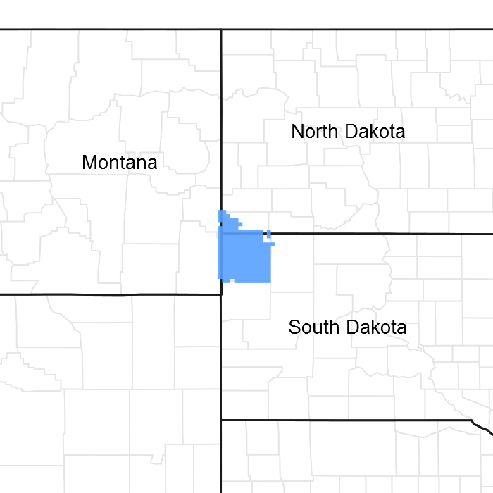
Figure 1. Mapped extent
Areas shown in blue indicate the maximum mapped extent of this ecological site. Other ecological sites likely occur within the highlighted areas. It is also possible for this ecological site to occur outside of highlighted areas if detailed soil survey has not been completed or recently updated.
MLRA notes
Major Land Resource Area (MLRA): 058D–Northern Rolling High Plains, Eastern Part
The Northern Rolling High Plains, Eastern Part (MLRA 58D) is shared between South Dakota (65 percent), Montana (21 percent), and North Dakota (14 percent). The MLRA is approximately 2,755 square miles. The small towns of Buffalo and Camp Crook, South Dakota, and Marmarth, North Dakota, are all within the boundary of this MLRA, and Baker, Montana, is on the northern most edge. Portions of the Little Missouri National Grassland and Custer National Forest are also in the MLRA. Portions of the Little Missouri River and the headwaters of major tributaries that eventually form the Grand and Moreau Rivers in South Dakota are also in this area.
The Northern Rolling High Plains, Eastern Part consists of Cretaceous marine and continental sediments of shale, siltstone, and sandstone. The continental and marine Hell Creek Formation is under approximately 85 percent of the MLRA, and the Fox Hills Sandstone forms the southern boundary of the MLRA. Tertiary deposits are in scattered areas throughout the MLRA. These deposits consist of the Paleocene Ludlow and Tongue River Formations, the Oligocene White River Group, and the Miocene Arikaree Group. These Tertiary deposits are resistant and positioned above the Cretaceous beds. Ponderosa pine growing in areas of these Tertiary formations further distinguishes these formations from the other formations in the MLRA. Pleistocene and Holocene river sand and gravel deposits are also on the valley floors and on the terraces along the larger rivers in the area. A large Quaternary eolian deposit is directly south of the town of Buffalo.
The average elevation of MLRA 58D ranges from 2,300 feet to 4,000 feet, increasing gradually from east to west. Harding Peak is the highest point at 4,019 feet. In places, flat-topped, steep-sided buttes rise sharply above the gently rolling plains below.
The dominant soil orders in this MLRA are Alfisols, Entisols, Inceptisols, and Mollisols. The soils in the area dominantly have a frigid soil temperature regime, an ustic soil moisture regime that borders on aridic, and mixed mineralogy. They are shallow to very deep, generally well drained, and loamy or clayey.
Annual precipitation is 14 to 17 inches and can fluctuate widely from year to year. The majority of rainfall occurs early in the growing season. Some high-intensity thunderstorms occur mid to late summer. The native vegetation in this MLRA consists primarily of grasses and forbs with a small component of trees and shrubs along streams. Ponderosa pine grow on the upper slopes and on the top of some of the higher buttes. Open grasslands are characterized by western wheatgrass, green needlegrass, blue grama, and buffalograss. Wyoming big sagebrush grows on clayey soils in the western part of the MLRA.
More than four-fifths of the MLRA is privately owned ranches running cattle, sheep, or both. Less than 5 percent of the area is federally owned. The major resource concerns are water quality, wind erosion, and water erosion (USDA, NRCS. 2006. Ag Handbook 296).
Classification relationships
USDA
Land Resource Region G—Western Great Plains Range and Irrigated Region:
Major Land Resource Area (MLRA) 58D— Northern Rolling High Plains, Eastern Part
US Environmental Protection Agency (EPA)
Level IV Ecoregions of the Conterminous United States:
Forested Buttes—43d
Sagebrush Steppe—43e
USDA Forest Service
Ecological Subregions: Sections and Subsections of Conterminous United States:
Great Plains - Palouse Dry Steppe Province—331:
Missouri Plateau Section—331M
Sagebrush Steppe Subsection—334Mi
Ecological site concept
The Shallow Sandy Ecological Site is found throughout MLRA 58D. It is located on upland landscapes and does not receive additional moisture from runoff or overflow. Slopes typically range from 6 to 40 percent. Soils are shallow (10 to 20 inches in depth), excessively drained, and formed in residuum weather from sandstone. The surface layer is 3 to 5 inches thick with textures of loamy fine sand to fine sandy loam. The subsurface textures are loamy fine sand to fine sand.
The vegetation in the Reference State (1.0) consists of a mix of warm- and cool-season grasses, however, tall- and mid-statured warm-season grasses tend to be the dominant group, cool-season grasses are subdominant. Prairie sandreed, needle and thread, and little bluestem, are the dominant grasses. Forbs are common and diverse. Common shrubs include fringed sagewort, rose, and small soapweed (yucca).
In the Slim Buttes area ponderosa pine can be a significant component in some plant communities.
Associated sites
| R058DY009SD |
Sandy The Sandy ecological site is found down slope or adjacent to the Shallow Sandy ecological site. |
|---|---|
| R058DY010SD |
Loamy The Loamy ecological site is found down slope of the Shallow Sandy ecological site. |
| R058DY026SD |
Thin Sandy The Thin Sandy ecological site is found on the same landscape positions as the Shallow Sandy site. The Thin Sandy soils are deep but with a thin surface layer. |
Similar sites
| R058DY010SD |
Loamy The Loamy ecological site will have more western wheatgrass, less needle and thread, and higher vegetative production than the Shallow Sandy ecological site. |
|---|---|
| R058DY009SD |
Sandy The Sandy ecological site will have more western wheatgrass, and more vegetative production than the Shallow Sandy ecological site. |
Table 1. Dominant plant species
| Tree |
Not specified |
|---|---|
| Shrub |
Not specified |
| Herbaceous |
(1) Calamovilfa longifolia |
Physiographic features
The Shallow Sandy ecological site occurs on moderate to steeply sloping uplands.
Table 2. Representative physiographic features
| Landforms |
(1)
Ridge
(2) Hillslope |
|---|---|
| Runoff class | Low |
| Flooding frequency | None |
| Ponding frequency | None |
| Elevation | 2,300 – 4,000 ft |
| Slope | 6 – 40% |
| Water table depth | 80 in |
| Aspect | Aspect is not a significant factor |
Climatic features
The climate in MLRA 58D is typical of the drier portions of the Northern Great Plains where sagebrush steppes to the west yield to grassland to the east. Average annual precipitation ranges from 14 to 17 inches with most falling in the early growing season. Some high intensity, convective thunderstorms occur in the summer. Precipitation in winter occurs as snow. Temperatures show a wide range between summer and winter and between daily maximums and minimums. This wide range is due to the high elevation and dry air, which permit rapid incoming and outgoing radiation. Outbreaks of cold air from Canada in winter move rapidly from northwest to southeast and account for extreme minimum temperatures. Extreme storms may occur during the winter but have the most severe effect on ranching operations during late winter and in spring.
The normal average annual temperature is about 44 °F. January is the coldest month with average temperatures ranging from about 12 °F (Marmarth, North Dakota) to about 20 °F (Baker, Montana). July is the warmest month with temperatures averaging from about 70 °F (Marmarth, North Dakota) to about 76 °F (Baker, Montana). The range of normal average monthly temperatures between the coldest and warmest months is about 55 °F. Wind speeds are estimated to average about 11 miles per hour (mph) annually, ranging from about 13 mph during the spring to about 10 mph during the summer. Daytime winds are generally stronger than nighttime winds. Strong storms may bring brief periods of high winds with gusts of more than 50 mph.
Growth of cool-season plants begins in early to mid-March, slowing or ceasing in late June. Warm-season plants begin growth about mid-May and continue to early or mid-September. Cool-season plants may green-up in September and October if adequate soil moisture is present.
Table 3. Representative climatic features
| Frost-free period (characteristic range) | 97-111 days |
|---|---|
| Freeze-free period (characteristic range) | 121-129 days |
| Precipitation total (characteristic range) | 15-17 in |
| Frost-free period (actual range) | 93-115 days |
| Freeze-free period (actual range) | 120-132 days |
| Precipitation total (actual range) | 14-17 in |
| Frost-free period (average) | 104 days |
| Freeze-free period (average) | 125 days |
| Precipitation total (average) | 16 in |
Figure 2. Monthly precipitation range
Figure 3. Monthly minimum temperature range
Figure 4. Monthly maximum temperature range
Figure 5. Monthly average minimum and maximum temperature
Figure 6. Annual precipitation pattern
Figure 7. Annual average temperature pattern
Climate stations used
-
(1) BAKER 1 E [USC00240412], Baker, MT
-
(2) LADNER 9SW [USC00394671], Camp Crook, SD
-
(3) CAMP CROOK [USC00391294], Camp Crook, SD
-
(4) BUFFALO ASOS [USW00094037], Buffalo, SD
-
(5) BUFFALO 13 ESE [USW00094081], Reva, SD
-
(6) REDIG 11 NE [USC00397062], Buffalo, SD
-
(7) HOOVER [USC00393945], Newell, SD
Influencing water features
No significant water features influence the Shallow Sandy ecological site.
Soil features
Soils common to the Shallow Sandy ecological site have loamy fine sand to fine sandy loam surface textures. The surface layer is 3 to 5 inches thick. Soils are shallow (10 to 20 inches in depth) formed in residuum weathered from sandstone. They are excessively drained and have a moderately rapid infiltration rate. Slopes range from 6 to 40 percent. The textures of the subsurface layer’s range from loamy fine sand to fine sand.
This site should show slight to no evidence of rills, wind-scoured areas, or pedestalled plants. Water flow paths are broken, irregular in appearance, or discontinuous with numerous vegetative barriers. The soil surface is stable and intact.
Major Soil correlated to the Shallow Sandy ecological site include, Blackhall, Flasher, Fleak, and Reva.
The Reva soil, in MLRA 58D, is found exclusively in the White River geological formation which makes up the Slim Buttes and other formations in the area. The Reva soil will likely have a ponderosa pine vegetative component. The other soils correlated to the Shallow Sandy ecological site in this MLRA will not.
These soils are susceptible to wind and water erosion. The hazard of water erosion increases on slopes greater than about 15 percent. Loss of 50 percent or more of the surface layer of the soils on this site can result in a shift in species composition and production.
More information can be found in the various soil survey reports. Contact the local USDA Service Center for soil survey reports that include more detail specific to your area of interest, or use the internet to access USDA’s Web Soil Survey.
Table 4. Representative soil features
| Parent material |
(1)
Residuum
–
sandstone
|
|---|---|
| Surface texture |
(1) Loamy fine sand (2) Fine sandy loam |
| Family particle size |
(1) Sandy |
| Drainage class | Excessively drained |
| Permeability class | Moderately rapid |
| Depth to restrictive layer | 10 – 20 in |
| Soil depth | 10 – 20 in |
| Surface fragment cover <=3" | 5% |
| Surface fragment cover >3" | 5% |
| Available water capacity (0-40in) |
1 – 2 in |
| Calcium carbonate equivalent (0-40in) |
10% |
| Electrical conductivity (0-40in) |
Not specified |
| Sodium adsorption ratio (0-40in) |
Not specified |
| Soil reaction (1:1 water) (0-40in) |
6.6 – 8.4 |
| Subsurface fragment volume <=3" (Depth not specified) |
5% |
| Subsurface fragment volume >3" (Depth not specified) |
5% |
Ecological dynamics
The Shallow Sandy ecological site developed under the Northern Great Plains climatic conditions, light to severe grazing by bison and other large herbivores, sporadic natural or human-caused wildfire (often of light intensities), and other biotic and abiotic factors that typically influence soil and site development. Changes will occur in the plant communities due to short-term weather variations, impacts of native and exotic plant and animal species, and management actions. While the following plant community descriptions specify more typical transitions between communities that will occur, severe disturbances, such as periods of well below-average precipitation, can cause significant shifts in plant communities and species composition.
As this site deteriorates, species such as threadleaf sedge and fringed sagewort will increase. Mid-grasses such as prairie sandreed and little bluestem will decrease in frequency and production.
The plant community upon which interpretations are primarily based is the Prairie Sandreed-Needle and Thread-Bluestem Plant Community (1.1). This plant community has been determined by studying rangeland relic areas, areas protected from excessive disturbance, and areas under long-term rotational grazing regimes. Trends in plant community dynamics ranging from heavily grazed to lightly grazed areas, seasonal use pastures, and historical accounts have also been used. Plant communities, states, transitional pathways, and thresholds have been determined through similar studies and experience.
Within the Slim Buttes formation, there is a potential for a Conifer State (3.0) with a plant community (3.1) consisting of ponderosa pine, possible Rocky Mountain juniper, shrubs, and an herbaceous understory.
The following is a State-and-Transition diagram that illustrates the common plant communities that can occur on the site and the transition pathways between communities. The ecological processes will be discussed in more detail in the plant community descriptions following the diagram.
State and transition model
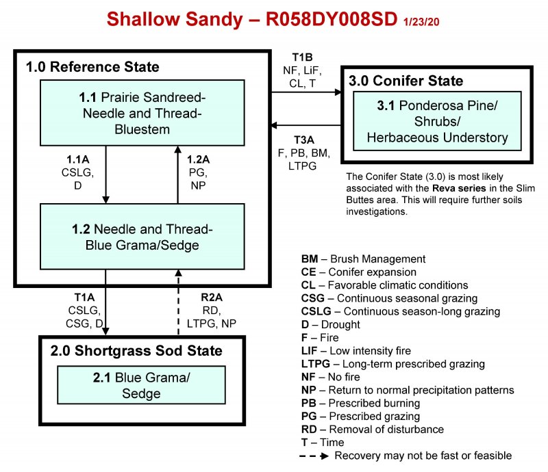
More interactive model formats are also available.
View Interactive Models
Click on state and transition labels to scroll to the respective text
Ecosystem states
State 1 submodel, plant communities
State 2 submodel, plant communities
State 3 submodel, plant communities
State 1
Reference State
The Reference State represents what is believed to show the natural range of variability that dominated the dynamics of the Shallow Sandy ecological site prior to European settlement. This site in the Reference State (1.0) is dominated by warm-season grasses and cool-season grasses subdominant. In pre-European times, the primary disturbance mechanisms included frequent fire and grazing by large herding ungulates. Timing and intensity of fires and grazing coupled with weather events dictated the dynamics that occurred within the natural range of variability. Taller warm- and cool-season grasses would have declined and a corresponding increase in short statured grass and grass-like species would have occurred. Today, a similar state can be found on areas that are properly managed with grazing and prescribed burning and sometimes on areas receiving occasional short periods of rest.
Dominant plant species
-
ponderosa pine (Pinus ponderosa), tree
-
western snowberry (Symphoricarpos occidentalis), shrub
-
chokecherry (Prunus virginiana), shrub
-
prairie sandreed (Calamovilfa longifolia), grass
-
needle and thread (Hesperostipa comata ssp. comata), grass
-
little bluestem (Schizachyrium scoparium), grass
-
plains muhly (Muhlenbergia cuspidata), grass
-
western wheatgrass (Pascopyrum smithii), grass
-
threadleaf sedge (Carex filifolia), grass
-
dotted blazing star (Liatris punctata), other herbaceous
-
tarragon (Artemisia dracunculus), other herbaceous
-
hairy false goldenaster (Heterotheca villosa), other herbaceous
-
beardtongue (Penstemon), other herbaceous
-
scurfpea (Psoralidium), other herbaceous
-
prairie sagewort (Artemisia frigida), other herbaceous
Community 1.1
Prairie Sandreed-Needle and Thread-Bluestem
Interpretations are based primarily on the Prairie Sandreed-Needle and Thread-Bluestem Plant Community, which is also considered to be the Reference Plant Community (1.1). This plant community can be found on areas that are properly managed with grazing, and sometimes on areas receiving occasional short periods of deferment. Warm-season grasses are dominant and cool-season grasses are subdominant. The potential vegetation is about 85 percent grasses or grass-like plants, 10 percent forbs, 5 percent shrubs and trees. The major grasses include prairie sandreed, needle and thread, and little bluestem. Other significant grasses and grass-like species occurring on the site include, plains muhly, western wheatgrass, and threadleaf sedge. Significant forbs include dotted gayfeather, green sagewort, hairy goldaster, penstemon, and scurfpea. The significant shrubs that occur include, fringed sagewort, rose, and yucca. This plant community is well adapted to the Northern Great Plains climatic conditions. Individual species can vary greatly in production depending on growing conditions (timing and amount of precipitation and temperature). The diversity in plant species allows for high drought tolerance. This is a healthy and sustainable plant community. This is a sustainable plant community (soil and site stability, watershed function, and biologic integrity).
Figure 8. Annual production by plant type (representative values) or group (midpoint values)
Table 5. Annual production by plant type
| Plant type | Low (lb/acre) |
Representative value (lb/acre) |
High (lb/acre) |
|---|---|---|---|
| Grass/Grasslike | 770 | 1120 | 1565 |
| Shrub/Vine | 65 | 105 | 145 |
| Forb | 65 | 105 | 145 |
| Tree | 0 | 70 | 145 |
| Total | 900 | 1400 | 2000 |
Figure 9. Plant community growth curve (percent production by month). SD5804, Northern Rolling High Plains, warm-season dominant, cool-season sub-dominant.. Warm-season dominant, cool-season sub-dominant, uplands..
| Jan | Feb | Mar | Apr | May | Jun | Jul | Aug | Sep | Oct | Nov | Dec |
|---|---|---|---|---|---|---|---|---|---|---|---|
| J | F | M | A | M | J | J | A | S | O | N | D |
| 0 | 0 | 3 | 7 | 18 | 24 | 25 | 15 | 7 | 1 | 0 | 0 |
Community 1.2
Needle and Thread-Blue Grama/Sedge
This plant community develops under continuous season-long grazing; continuous seasonal grazing; or from over utilization during extended drought periods. The potential vegetation is about 85 percent grasses or grass-like plants, 10 percent forbs, 5 percent shrubs and trees. The dominant grasses include needle and thread, blue grama, and threadleaf sedge. Other grasses or grass-like species may include prairie sandreed, little bluestem, plains muhly, and upland sedges. Significant forbs include cudweed sagewort, green sagewort, scurfpea, and western ragweed. The dominant shrubs that occur include cactus, yucca, and fringed sagewort. Compared to the Prairie Sandreed-Needle and Thread-Bluestem Plant Community (1.1), prairie sandreed, sand bluestem, and little bluestem have decreased. Needle and thread, blue grama, and threadleaf sedge have increased. This community is well suited to grazing by both domestic livestock and wildlife, during the spring summer and fall. The communities’ soil, biotic integrity and watershed are intact, although more than normal runoff may occur due to the sod forming vegetation. This plant community can occur in a mosaic with patchy, slightly used areas occurring adjacent to and intermingled with this plant community.
Figure 10. Annual production by plant type (representative values) or group (midpoint values)
Table 6. Annual production by plant type
| Plant type | Low (lb/acre) |
Representative value (lb/acre) |
High (lb/acre) |
|---|---|---|---|
| Grass/Grasslike | 600 | 880 | 1255 |
| Forb | 50 | 83 | 115 |
| Shrub/Vine | 50 | 80 | 115 |
| Tree | 0 | 55 | 110 |
| Moss | 0 | 2 | 5 |
| Total | 700 | 1100 | 1600 |
Figure 11. Plant community growth curve (percent production by month). SD5803, Northern Rolling High Plains, cool-season/warm-season co-dominant.. Cool-season, warm-season co-dominant, uplands..
| Jan | Feb | Mar | Apr | May | Jun | Jul | Aug | Sep | Oct | Nov | Dec |
|---|---|---|---|---|---|---|---|---|---|---|---|
| J | F | M | A | M | J | J | A | S | O | N | D |
| 0 | 0 | 3 | 10 | 20 | 28 | 21 | 10 | 5 | 3 | 0 | 0 |
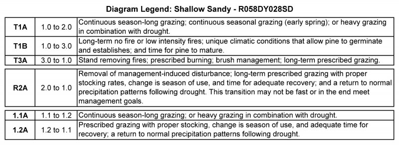
Pathway 1.1A
Community 1.1 to 1.2
Continuous season-long grazing; continuous seasonal grazing (early spring); or heavy grazing in combination with drought will lead to the Prairie Sandreed-Needle and Thread-Bluestem Plant Community (1.1) to the Needle and Thread-Blue Grama/Sedge (1.2).
Pathway 1.2A
Community 1.2 to 1.1
Prescribed grazing with proper stocking rates, change in season of use, and adequate time for plant recovery; and a return to normal precipitation patterns following drought will convert the Needle and Thread-Blue Grama/Sedge Plant Community (1.2) to the Prairie Sandreed-Needle and Thread-Bluestem Plant Community (1.1).
Conservation practices
| Prescribed Grazing |
|---|
State 2
Shortgrass Sod State
The Shortgrass Sod State (2.0) is dominated by shortgrass species, and upland sedges. This State is the result of grazing management that does not provide adequate recovery time for cool-season needlegrass and tall and mid-statured warm-season grasses. The hydrologic function of this state is dramatically altered. Runoff is high and infiltration is low. This State is very resistant to change through grazing management alone.
Dominant plant species
-
blue grama (Bouteloua gracilis), grass
-
sedge (Carex), grass
-
needle and thread (Hesperostipa comata ssp. comata), grass
-
prairie Junegrass (Koeleria macrantha), grass
-
bluegrass (Poa), grass
-
cheatgrass (Bromus tectorum), grass
-
white sagebrush (Artemisia ludoviciana), other herbaceous
-
scurfpea (Psoralidium), other herbaceous
-
Cuman ragweed (Ambrosia psilostachya), other herbaceous
-
prairie sagewort (Artemisia frigida), other herbaceous
-
pricklypear (Opuntia), other herbaceous
-
yucca (Yucca), other herbaceous
Community 2.1
Blue Grama/Sedge
This plant community develops under continuous season-long grazing, or continuous seasonal grazing, often with concentrated use in the early part of the growing season (as in calving/lambing pastures). It is made up of approximately 80 percent grasses (primarily short grass and grass-like species), 10 percent forbs, 10 percent shrubs and trees. The dominant grass and grass-like species include sedge and blue grama. Other grasses may include needle and thread, prairie Junegrass, bluegrass, and cheatgrass. The dominant forbs include cudweed sagewort, scurfpea, and western ragweed. The dominant shrubs include fringed sagewort, cactus, and yucca. Compared to the Prairie Sandreed-Needle and Thread-Bluestem Plant Community (1.1), blue grama, and sedge have increased, and the cool- and warm-season mid and tall grasses have diminished greatly. Non-palatable forbs and cactus have increased, and non-native species have invaded the site. Plant diversity is low. This plant community is very stable. Generally, this plant community will require significant management inputs (i.e., high animal impact, long-term prescribed grazing, favorable climatic conditions, etc.,) and time to move it towards the Reference State (1.0). Onsite soil erosion is low. Infiltration is low and runoff is high. Typically, the runoff is very clean because of the low potential for onsite soil erosion. However, offsite areas can be significantly impacted due to the increased runoff.
Figure 12. Annual production by plant type (representative values) or group (midpoint values)
Table 7. Annual production by plant type
| Plant type | Low (lb/acre) |
Representative value (lb/acre) |
High (lb/acre) |
|---|---|---|---|
| Grass/Grasslike | 430 | 597 | 960 |
| Shrub/Vine | 35 | 80 | 125 |
| Forb | 35 | 80 | 120 |
| Tree | 0 | 40 | 85 |
| Moss | 0 | 3 | 10 |
| Total | 500 | 800 | 1300 |
Figure 13. Plant community growth curve (percent production by month). SD5803, Northern Rolling High Plains, cool-season/warm-season co-dominant.. Cool-season, warm-season co-dominant, uplands..
| Jan | Feb | Mar | Apr | May | Jun | Jul | Aug | Sep | Oct | Nov | Dec |
|---|---|---|---|---|---|---|---|---|---|---|---|
| J | F | M | A | M | J | J | A | S | O | N | D |
| 0 | 0 | 3 | 10 | 20 | 28 | 21 | 10 | 5 | 3 | 0 | 0 |
State 3
Conifer State
The Conifer State is primally found in the areas that have the White River geological formations such as Slim Buttes. This state occurs when ponderosa pine become established or expand on this site. As conifer canopy cover increases, the herbaceous component will decrease, bare ground increases and pine needles build up and create a duff layer. As competition from herbaceous species decrease, conifers can establish more readily under the canopy. Heavy grazing can contribute to this transition, but it may also occur independently without human influence other than through fire suppression. The Slim Buttes area is drier than the Black Hills (MLRA 62) where expansive stands of ponderosa pine occur, and pine regenerates readily following fire. MLRA 58D is located on the eastern edge of the ponderosa pine range. MLRA 58D probably does not have consistent climatic conditions necessary for ponderosa pine germination and regeneration. Those conditions may be episodic as they are in the drier American southwest. Regeneration of ponderosa pine in New Mexico, Arizona, and western Nebraska are strongly episodic and the basis of these pulses are at least partly controlled by climate. Ponderosa pine in the Southwest require a warm wet spring and an above-average water supply throughout the year for germination to occur and seedlings to establish. One study from northern Arizona showed a large cohort of ponderosa pine that established within a two-year period between 1919 and 1920 when optimal combination of temperature and precipitation factors occurred. This episodic event was not repeated for 73 years (Savage, M., et al, 1996). Successful establishment of ponderosa pine in the Great Plains is unpredictable and requires a combination of sufficient seed availability, adequate year-long soil moisture, a lack of persistent drought, and no fire that affects seedling survival (Kaye et al., 2010). The Conifer State on the Shallow Sandy ecological sites may be limited in extent, especially those plant communities having large ponderosa pine components. As high intensity, medium to large sized wildfires occur, these plant communities may become less common as grassland communities replace these woodlands.
Dominant plant species
-
ponderosa pine (Pinus ponderosa), tree
-
western snowberry (Symphoricarpos occidentalis), shrub
-
chokecherry (Prunus virginiana), shrub
-
needle and thread (Hesperostipa comata ssp. comata), grass
-
little bluestem (Schizachyrium scoparium), grass
-
sideoats grama (Bouteloua curtipendula), grass
-
blue grama (Bouteloua gracilis), grass
-
sedge (Carex), grass
-
Canada wildrye (Elymus canadensis), grass
-
green needlegrass (Nassella viridula), grass
-
western wheatgrass (Pascopyrum smithii), grass
-
white sagebrush (Artemisia ludoviciana), other herbaceous
-
common yarrow (Achillea millefolium), other herbaceous
-
pussytoes (Antennaria), other herbaceous
-
prairie sagewort (Artemisia frigida), other herbaceous
Community 3.1
Ponderosa Pine/Shrubs/Herbaceous Understory
Historically, ponderosa pine and juniper were confined to ridges and steep, north- or east-facing slopes that were located adjacent to rock outcrops. This plant community has developed due to fire suppression and the expansion of ponderosa pine on the ecological site. Ponderosa pine canopy make up approximately 15 percent mature trees in this plant community. The understory is made up of about 80 percent grasses and grass-like species, 10 percent forbs, and 10 percent shrubs. Dominant grasses and grass-likes include needle and thread, little bluestem, sideoats grama, blue grama and sedge. Grasses of secondary importance include Canada wildrye, green needlegrass and western wheatgrass. Forbs commonly found in this community include cudweed sagewort, western yarrow, and pussytoes. Shrubs can include fringed sagewort, western snowberry, and chokecherry. When compared to the Prairie Sandreed-Needle and Thread-Bluestem Plant Community (1.1), ponderosa pine increases. The grass component decreases as pine and juniper needles increases. Annual herbaceous production has also decreased. While the conifer canopy provides excellent protection from the weather for both livestock and wildlife, it is not capable of supporting large numbers of wildlife and livestock due to decreased production. This plant community is resistant to change. A significant reduction of conifers can only be accomplished through fire, or mechanical removal. The vegetation in the understory is capable of enduring fire without a detrimental effect to the site and the associated plant community.
Figure 14. Plant community growth curve (percent production by month). SD5811, Northern Rolling High Plains, heavy conifer canopy.. Mature ponderosa pine/juniper overstory..
| Jan | Feb | Mar | Apr | May | Jun | Jul | Aug | Sep | Oct | Nov | Dec |
|---|---|---|---|---|---|---|---|---|---|---|---|
| J | F | M | A | M | J | J | A | S | O | N | D |
| 1 | 3 | 7 | 11 | 24 | 27 | 12 | 5 | 4 | 3 | 2 | 1 |
Transition T1A
State 1 to 2
Continuous season-long grazing; or continuous seasonal grazing (early spring); or heavy grazing in combination with drought; will transition the Reference State (1.0) to the Shortgrass Sod State (2.0). This transition is most likely to occur from the Needle and Thread-Blue Grama/Sedge Plant Community (1.2).
Transition T1B
State 1 to 3
Long-term fire suppression or periodic low intensity fires; favorable climatic conditions that allow for pine regeneration and establishment, expansion of conifers, and time will transition the Reference State (1.0) to the Conifer State (3.0).
Restoration pathway R2A
State 2 to 1
Removal of disturbances; long-term prescribed grazing, and favorable climatic conditions, which allow for adequate plant recovery periods, may allow for a transition from the Shortgrass Sod State (2.0) to the Reference State (1.0). This transition may not be rapid or in the end meet management goals.
Conservation practices
| Prescribed Grazing |
|---|
Restoration pathway T3A
State 3 to 1
Prescribed burning or wildfire followed by long-term prescribed grazing will move this plant community towards the herbaceous dominated Reference State (1.0). Mechanical removal of pine/juniper, through bush management, followed by long-term prescribed grazing may also allow the understory to develop and transition to the Reference State (1.0). Trees located on the steeper escarpments and deeper canyons may escape most fires and provide a seed source for ponderosa pine expansion in the future.
Conservation practices
| Brush Management | |
|---|---|
| Prescribed Burning | |
| Prescribed Grazing |
Additional community tables
Table 8. Community 1.1 plant community composition
| Group | Common name | Symbol | Scientific name | Annual production (lb/acre) | Foliar cover (%) | |
|---|---|---|---|---|---|---|
|
Grass/Grasslike
|
||||||
| 1 | Tall Warm-Season Grasses | 280–490 | ||||
| prairie sandreed | CALO | Calamovilfa longifolia | 210–420 | – | ||
| sand bluestem | ANHA | Andropogon hallii | 28–140 | – | ||
| big bluestem | ANGE | Andropogon gerardii | 0–70 | – | ||
| 2 | Cool-Season Bunchgrass | 140–280 | ||||
| needle and thread | HECOC8 | Hesperostipa comata ssp. comata | 140–280 | – | ||
| green needlegrass | NAVI4 | Nassella viridula | 0–70 | – | ||
| bluebunch wheatgrass | PSSP6 | Pseudoroegneria spicata | 0–70 | – | ||
| slender wheatgrass | ELTR7 | Elymus trachycaulus | 0–70 | – | ||
| 3 | Mid- Warm-Season Grasses | 70–280 | ||||
| little bluestem | SCSC | Schizachyrium scoparium | 70–210 | – | ||
| plains muhly | MUCU3 | Muhlenbergia cuspidata | 14–140 | – | ||
| sideoats grama | BOCU | Bouteloua curtipendula | 0–70 | – | ||
| Grass, perennial | 2GP | Grass, perennial | 0–70 | – | ||
| 4 | Short-Warm Season Grasses | 28–112 | ||||
| blue grama | BOGR2 | Bouteloua gracilis | 14–70 | – | ||
| hairy grama | BOHI2 | Bouteloua hirsuta | 14–70 | – | ||
| sand dropseed | SPCR | Sporobolus cryptandrus | 14–70 | – | ||
| Fendler threeawn | ARPUL | Aristida purpurea var. longiseta | 0–42 | – | ||
| 5 | Other Native Cool-Season Grasses | 70–210 | ||||
| western wheatgrass | PASM | Pascopyrum smithii | 28–140 | – | ||
| thickspike wheatgrass | ELLAL | Elymus lanceolatus ssp. lanceolatus | 0–70 | – | ||
| prairie Junegrass | KOMA | Koeleria macrantha | 14–70 | – | ||
| Grass, perennial | 2GP | Grass, perennial | 0–70 | – | ||
| Scribner's rosette grass | DIOLS | Dichanthelium oligosanthes var. scribnerianum | 14–28 | – | ||
| 6 | Grass-Likes | 28–140 | ||||
| threadleaf sedge | CAFI | Carex filifolia | 28–140 | – | ||
| needleleaf sedge | CADU6 | Carex duriuscula | 14–42 | – | ||
| Grass-like (not a true grass) | 2GL | Grass-like (not a true grass) | 0–28 | – | ||
| 7 | Non-Native Cool-Season Grasses | 0 | ||||
|
Forb
|
||||||
| 8 | Forbs | 70–140 | ||||
| Forb, native | 2FN | Forb, native | 14–70 | – | ||
| stiff sunflower | HEPA19 | Helianthus pauciflorus | 14–42 | – | ||
| white sagebrush | ARLU | Artemisia ludoviciana | 14–42 | – | ||
| field sagewort | ARCA12 | Artemisia campestris | 14–42 | – | ||
| hairy false goldenaster | HEVI4 | Heterotheca villosa | 14–28 | – | ||
| purple locoweed | OXLA3 | Oxytropis lambertii | 14–28 | – | ||
| dotted blazing star | LIPU | Liatris punctata | 14–28 | – | ||
| goldenrod | SOLID | Solidago | 14–28 | – | ||
| upright prairie coneflower | RACO3 | Ratibida columnifera | 14–28 | – | ||
| American vetch | VIAM | Vicia americana | 14–28 | – | ||
| purple prairie clover | DAPU5 | Dalea purpurea | 14–28 | – | ||
| scarlet beeblossom | GACO5 | Gaura coccinea | 14–28 | – | ||
| scurfpea | PSORA2 | Psoralidium | 14–28 | – | ||
| spiny phlox | PHHO | Phlox hoodii | 0–14 | – | ||
| pussytoes | ANTEN | Antennaria | 0–14 | – | ||
| rush skeletonplant | LYJU | Lygodesmia juncea | 0–14 | – | ||
| wavyleaf thistle | CIUN | Cirsium undulatum | 0–14 | – | ||
| Cuman ragweed | AMPS | Ambrosia psilostachya | 0–14 | – | ||
| western yarrow | ACMIO | Achillea millefolium var. occidentalis | 0–14 | – | ||
| longbract spiderwort | TRBR | Tradescantia bracteata | 0–14 | – | ||
| western marbleseed | ONBEO | Onosmodium bejariense var. occidentale | 0–14 | – | ||
| cutleaf anemone | PUPAM | Pulsatilla patens ssp. multifida | 0–14 | – | ||
| blacksamson echinacea | ECAN2 | Echinacea angustifolia | 0–14 | – | ||
| milkvetch | ASTRA | Astragalus | 0–14 | – | ||
| narrowleaf stoneseed | LIIN2 | Lithospermum incisum | 0–14 | – | ||
| beardtongue | PENST | Penstemon | 0–14 | – | ||
| lesser spikemoss | SEDE2 | Selaginella densa | 0 | – | ||
|
Moss
|
||||||
| 9 | Mat-Forming Forbs | 0 | ||||
|
Shrub/Vine
|
||||||
| 10 | Shrubs | 70–140 | ||||
| western snowberry | SYOC | Symphoricarpos occidentalis | 0–70 | – | ||
| silver sagebrush | ARCA13 | Artemisia cana | 0–70 | – | ||
| Shrub (>.5m) | 2SHRUB | Shrub (>.5m) | 0–70 | – | ||
| rose | ROSA5 | Rosa | 14–42 | – | ||
| skunkbush sumac | RHTR | Rhus trilobata | 0–42 | – | ||
| soapweed yucca | YUGL | Yucca glauca | 14–28 | – | ||
| leadplant | AMCA6 | Amorpha canescens | 0–28 | – | ||
| silver buffaloberry | SHAR | Shepherdia argentea | 0–28 | – | ||
| creeping juniper | JUHO2 | Juniperus horizontalis | 0–28 | – | ||
| prairie sagewort | ARFR4 | Artemisia frigida | 14–28 | – | ||
| pricklypear | OPUNT | Opuntia | 0–14 | – | ||
|
Tree
|
||||||
| 11 | Trees | 0–140 | ||||
| ponderosa pine | PIPO | Pinus ponderosa | 0–140 | – | ||
| Tree, deciduous | 2TD | Tree, deciduous | 0–112 | – | ||
| Rocky Mountain juniper | JUSC2 | Juniperus scopulorum | 0–70 | – | ||
| Tree | 2TREE | Tree | 0–28 | – | ||
Table 9. Community 1.2 plant community composition
| Group | Common name | Symbol | Scientific name | Annual production (lb/acre) | Foliar cover (%) | |
|---|---|---|---|---|---|---|
|
Grass/Grasslike
|
||||||
| 1 | Tall Warm-Season Grasses | 22–165 | ||||
| prairie sandreed | CALO | Calamovilfa longifolia | 22–165 | – | ||
| sand bluestem | ANHA | Andropogon hallii | 0–44 | – | ||
| big bluestem | ANGE | Andropogon gerardii | 0–33 | – | ||
| 2 | Cool-Season Bunchgrass | 165–275 | ||||
| needle and thread | HECOC8 | Hesperostipa comata ssp. comata | 165–275 | – | ||
| slender wheatgrass | ELTR7 | Elymus trachycaulus | 0–55 | – | ||
| green needlegrass | NAVI4 | Nassella viridula | 0–33 | – | ||
| bluebunch wheatgrass | PSSP6 | Pseudoroegneria spicata | 0–11 | – | ||
| 3 | Mid- Warm-Season Bunchgrass | 0–55 | ||||
| little bluestem | SCSC | Schizachyrium scoparium | 0–55 | – | ||
| plains muhly | MUCU3 | Muhlenbergia cuspidata | 0–55 | – | ||
| Grass, perennial | 2GP | Grass, perennial | 0–55 | – | ||
| sideoats grama | BOCU | Bouteloua curtipendula | 0–33 | – | ||
| 4 | Short-Warm Season Grasses | 110–220 | ||||
| blue grama | BOGR2 | Bouteloua gracilis | 55–165 | – | ||
| hairy grama | BOHI2 | Bouteloua hirsuta | 22–88 | – | ||
| sand dropseed | SPCR | Sporobolus cryptandrus | 22–88 | – | ||
| Fendler threeawn | ARPUL | Aristida purpurea var. longiseta | 11–55 | – | ||
| 5 | Other Native Cool-Season Grasses | 55–110 | ||||
| western wheatgrass | PASM | Pascopyrum smithii | 11–55 | – | ||
| Grass, perennial | 2GP | Grass, perennial | 0–55 | – | ||
| prairie Junegrass | KOMA | Koeleria macrantha | 11–55 | – | ||
| Scribner's rosette grass | DIOLS | Dichanthelium oligosanthes var. scribnerianum | 11–33 | – | ||
| thickspike wheatgrass | ELLAL | Elymus lanceolatus ssp. lanceolatus | 0–33 | – | ||
| 6 | Grass-Likes | 165–275 | ||||
| threadleaf sedge | CAFI | Carex filifolia | 110–220 | – | ||
| needleleaf sedge | CADU6 | Carex duriuscula | 22–88 | – | ||
| Grass-like (not a true grass) | 2GL | Grass-like (not a true grass) | 0–22 | – | ||
| 7 | Non-Native Cool-Season Grasses | 11–55 | ||||
| Kentucky bluegrass | POPR | Poa pratensis | 0–55 | – | ||
| cheatgrass | BRTE | Bromus tectorum | 11–55 | – | ||
| field brome | BRAR5 | Bromus arvensis | 0–55 | – | ||
|
Forb
|
||||||
| 8 | Forbs | 55–110 | ||||
| white sagebrush | ARLU | Artemisia ludoviciana | 11–55 | – | ||
| field sagewort | ARCA12 | Artemisia campestris | 11–55 | – | ||
| Forb, native | 2FN | Forb, native | 11–55 | – | ||
| Forb, introduced | 2FI | Forb, introduced | 0–55 | – | ||
| scurfpea | PSORA2 | Psoralidium | 11–33 | – | ||
| Cuman ragweed | AMPS | Ambrosia psilostachya | 11–22 | – | ||
| western yarrow | ACMIO | Achillea millefolium var. occidentalis | 0–22 | – | ||
| goldenrod | SOLID | Solidago | 11–22 | – | ||
| lesser spikemoss | SEDE2 | Selaginella densa | 0–11 | – | ||
| spiny phlox | PHHO | Phlox hoodii | 0–11 | – | ||
| stiff sunflower | HEPA19 | Helianthus pauciflorus | 0–11 | – | ||
| wavyleaf thistle | CIUN | Cirsium undulatum | 0–11 | – | ||
| hairy false goldenaster | HEVI4 | Heterotheca villosa | 0–11 | – | ||
| purple locoweed | OXLA3 | Oxytropis lambertii | 0–11 | – | ||
| milkvetch | ASTRA | Astragalus | 0–11 | – | ||
| upright prairie coneflower | RACO3 | Ratibida columnifera | 0–11 | – | ||
| blacksamson echinacea | ECAN2 | Echinacea angustifolia | 0–11 | – | ||
| purple prairie clover | DAPU5 | Dalea purpurea | 0–11 | – | ||
| pussytoes | ANTEN | Antennaria | 0–11 | – | ||
| rush skeletonplant | LYJU | Lygodesmia juncea | 0–11 | – | ||
| scarlet beeblossom | GACO5 | Gaura coccinea | 0–11 | – | ||
| dotted blazing star | LIPU | Liatris punctata | 0–11 | – | ||
| American vetch | VIAM | Vicia americana | 0–11 | – | ||
| longbract spiderwort | TRBR | Tradescantia bracteata | 0–11 | – | ||
|
Moss
|
||||||
| 9 | Mat-Forming Forbs | 0–33 | ||||
| lesser spikemoss | SEDE2 | Selaginella densa | 0–33 | – | ||
|
Shrub/Vine
|
||||||
| 10 | Shrubs | 55–110 | ||||
| Shrub (>.5m) | 2SHRUB | Shrub (>.5m) | 0–55 | – | ||
| prairie sagewort | ARFR4 | Artemisia frigida | 11–55 | – | ||
| creeping juniper | JUHO2 | Juniperus horizontalis | 11–44 | – | ||
| rose | ROSA5 | Rosa | 11–22 | – | ||
| skunkbush sumac | RHTR | Rhus trilobata | 0–22 | – | ||
| pricklypear | OPUNT | Opuntia | 0–22 | – | ||
| soapweed yucca | YUGL | Yucca glauca | 0–11 | – | ||
| leadplant | AMCA6 | Amorpha canescens | 0–11 | – | ||
| western snowberry | SYOC | Symphoricarpos occidentalis | 0–11 | – | ||
| silver sagebrush | ARCA13 | Artemisia cana | 0–11 | – | ||
| silver buffaloberry | SHAR | Shepherdia argentea | 0–11 | – | ||
|
Tree
|
||||||
| 11 | Trees | 0–10 | ||||
| ponderosa pine | PIPO | Pinus ponderosa | 0–110 | – | ||
| Tree, deciduous | 2TD | Tree, deciduous | 0–88 | – | ||
| Rocky Mountain juniper | JUSC2 | Juniperus scopulorum | 0–55 | – | ||
| Tree | 2TREE | Tree | 0–11 | – | ||
Table 10. Community 2.1 plant community composition
| Group | Common name | Symbol | Scientific name | Annual production (lb/acre) | Foliar cover (%) | |
|---|---|---|---|---|---|---|
|
Grass/Grasslike
|
||||||
| 1 | Tall Warm-Season Grasses | 0–40 | ||||
| prairie sandreed | CALO | Calamovilfa longifolia | 0–40 | – | ||
| 2 | Cool-Season Bunchgrass | 8–64 | ||||
| needle and thread | HECOC8 | Hesperostipa comata ssp. comata | 8–64 | – | ||
| slender wheatgrass | ELTR7 | Elymus trachycaulus | 0–16 | – | ||
| 3 | Mid- Warm-Season Bunchgrass | 0–16 | ||||
| little bluestem | SCSC | Schizachyrium scoparium | 0–16 | – | ||
| 4 | Short-Warm Season Grasses | 120–200 | ||||
| blue grama | BOGR2 | Bouteloua gracilis | 80–160 | – | ||
| hairy grama | BOHI2 | Bouteloua hirsuta | 16–80 | – | ||
| sand dropseed | SPCR | Sporobolus cryptandrus | 8–80 | – | ||
| Fendler threeawn | ARPUL | Aristida purpurea var. longiseta | 8–80 | – | ||
| 5 | Other Native Cool-Season Grasses | 16–64 | ||||
| Grass, perennial | 2GP | Grass, perennial | 0–40 | – | ||
| prairie Junegrass | KOMA | Koeleria macrantha | 8–32 | – | ||
| Scribner's rosette grass | DIOLS | Dichanthelium oligosanthes var. scribnerianum | 8–16 | – | ||
| western wheatgrass | PASM | Pascopyrum smithii | 0–8 | – | ||
| 6 | Grass-Likes | 160–320 | ||||
| threadleaf sedge | CAFI | Carex filifolia | 120–280 | – | ||
| needleleaf sedge | CADU6 | Carex duriuscula | 40–80 | – | ||
| Grass-like (not a true grass) | 2GL | Grass-like (not a true grass) | 0–40 | – | ||
| 7 | Non-Native Cool-Season Grasses | 8–56 | ||||
| cheatgrass | BRTE | Bromus tectorum | 8–56 | – | ||
| field brome | BRAR5 | Bromus arvensis | 0–40 | – | ||
| Kentucky bluegrass | POPR | Poa pratensis | 0–40 | – | ||
|
Forb
|
||||||
| 8 | Forbs | 40–120 | ||||
| white sagebrush | ARLU | Artemisia ludoviciana | 16–56 | – | ||
| field sagewort | ARCA12 | Artemisia campestris | 8–56 | – | ||
| Forb, introduced | 2FI | Forb, introduced | 8–56 | – | ||
| scurfpea | PSORA2 | Psoralidium | 8–40 | – | ||
| lesser spikemoss | SEDE2 | Selaginella densa | 8–40 | – | ||
| Forb, native | 2FN | Forb, native | 0–24 | – | ||
| Cuman ragweed | AMPS | Ambrosia psilostachya | 8–24 | – | ||
| western yarrow | ACMIO | Achillea millefolium var. occidentalis | 0–24 | – | ||
| goldenrod | SOLID | Solidago | 8–16 | – | ||
| milkvetch | ASTRA | Astragalus | 0–8 | – | ||
| pussytoes | ANTEN | Antennaria | 0–8 | – | ||
| rush skeletonplant | LYJU | Lygodesmia juncea | 0–8 | – | ||
| spiny phlox | PHHO | Phlox hoodii | 0–8 | – | ||
|
Moss
|
||||||
| 9 | Mat-Forming Forbs | 0–40 | ||||
| lesser spikemoss | SEDE2 | Selaginella densa | 0–40 | – | ||
|
Shrub/Vine
|
||||||
| 10 | Shrubs | 40–120 | ||||
| prairie sagewort | ARFR4 | Artemisia frigida | 16–80 | – | ||
| creeping juniper | JUHO2 | Juniperus horizontalis | 8–64 | – | ||
| pricklypear | OPUNT | Opuntia | 8–32 | – | ||
| Shrub (>.5m) | 2SHRUB | Shrub (>.5m) | 0–24 | – | ||
| rose | ROSA5 | Rosa | 0–8 | – | ||
|
Tree
|
||||||
| 11 | Trees | 0–80 | ||||
| ponderosa pine | PIPO | Pinus ponderosa | 0–80 | – | ||
| Rocky Mountain juniper | JUSC2 | Juniperus scopulorum | 0–64 | – | ||
| Tree, deciduous | 2TD | Tree, deciduous | 0–64 | – | ||
| Tree | 2TREE | Tree | 0–24 | – | ||
Interpretations
Animal community
Wildlife Interpretations
MLRA 58D lies within the drier portion of the northern mixed-grass prairie ecosystem where sagebrush steppes to the west yield to grassland steppes to the east. Prior to European settlement, this area consisted of diverse grass- and shrubland habitats interspersed with varying densities of depressional instream wetlands and woody riparian corridors. These habitats provided critical life cycle components for many users. Many species of grassland birds, small mammals, reptiles, amphibians, and herds of roaming bison, elk, and pronghorn were among the inhabitants adapted to this semi-arid region. Roaming herbivores, as well as several small mammal and insect species, were the primary consumers linking the grassland resources to predators such as the gray wolf, mountain lion, and grizzly bear, and smaller carnivores such as the coyote, bobcat, fox, and raptors. The prairie dog was once abundant; however, the species remains a keystone species within its range. The black-footed ferret, burrowing owl, ferruginous hawk, mountain plover, and swift fox were associated with prairie dog complexes.
Historically, the northern mixed-grass prairie was a disturbance-driven ecosystem with fire, herbivory, and climate functioning as the primary disturbance factors either singly or in combination. Following European settlement, livestock grazing, cropland conversion, elimination of fire, energy development, and other anthropogenic factors influenced species composition and abundance. Introduced and invasive species further impacted plant and animal communities. The bison was a historical keystone species, but had been extirpated in this area as a free-ranging herbivore. The loss of the bison and reduction of prairie dog populations and fire as ecological drivers greatly influenced the character of the remaining native plant communities and altered wildlife habitats. Human development has reduced habitat quality for area-sensitive species.
Within MLRA 58D, the Shallow Sandy ecological site provides upland grassland cover with an associated forb component. It was typically part of an expansive grassland landscape that included combinations of Loamy, Shallow Loamy, Shallow Clayey, Thin Loamy, Claypan, Sands,
Sandy, Sandy Claypan, Clayey, and Thin Claypan ecological sites.
This site provided habitat for species requiring unfragmented grassland. Important habitat features, and components found commonly or exclusively on this site may include sharp-tailed grouse leks; upland nesting habitat for grassland birds, forbs and insects for brood habitat; and a forage source for small and large herbivores. Many grassland and shrub steppe nesting bird populations are declining. Extirpated species include free-ranging American bison, grizzly bear, gray wolf, black-footed ferret, mountain plover, Rocky Mountain locust, and swift fox.
The majority of the Shallow Sandy ecological site remains intact and provides increasingly important habitat for grassland nesting birds, small rodents, coyotes, and a variety of reptiles, amphibians, and insects. Invasive species such as annual bromegrasses and crested wheat have impacted the biological integrity of the site for some grassland birds.
Prairie Sandreed-Needle and Thread-Bluestem (1.1) and
Needle and Thread-Blue Grama/Sedge (1.2): The predominance of grasses plus high diversity of forbs and shrubs in this community favors grazers and mixed-feeders, such as deer and pronghorn. Insects, such as pollinators, play a large role in maintaining the forb community and provide a forage base for grassland birds and other species. The complex plant structural diversity provides habitat for a wide array of migratory and resident birds. Grasshopper sparrow, lark bunting, western meadowlark, and sharp-tailed grouse are common and benefit from the structure and composition this plant community provides. Diverse prey populations are available for grassland raptors such as ferruginous hawk, Swainson’s hawk, golden eagle, and prairie falcon.
The diversity of grasses, forbs, and shrubs provide high nutrition levels for small and large herbivores including voles, mice, thirteen-lined ground squirrel, white-tailed jackrabbit, and deer. The higher stature of this plant community provides thermal, protective, and escape cover for herbivores and grassland birds. Predators utilizing this plant community include coyote, American badger, red fox, and long-tailed weasel. This plant community provides habitat for herptiles such as the spade foot toad, bull snake, and western rattlesnake.
Resulting from continuous season-long grazing, the warm-season grass component has been
substantially reduced and a shift to a needle and thread, blue grama, and sedge community occurs. The forb and shrub diversity have not substantially decreased. The shift from the Reference Plant Community (1.1) to the Needle and Thread-Blue Grama/Sedge Plant Community (1.2) does not result in a significant change to the wildlife community.
Blue Grama/Sedge Plant Community (2.1): Resulting from continuous season-long grazing without adequate recovery periods between grazing events; sedges, and blue grama will dominate. The forb diversity has decreased. A shift to shorter plant structure will favor prairie dog expansion and associate species such as ferruginous hawk, burrowing owl, tiger salamander, and swift fox. Species such as horned lark, long-billed curlew, upland sandpiper, and white-tailed jackrabbit will increase due to the loss of the tall grass component. Density of species such as Brewer’s sparrow, greater sage-grouse, as well as, desert cottontail will decline. However, this plant community may provide areas suitable for lek site development.
The short stature of this plant community limits thermal, protective, and escape cover. Predators utilizing this plant community include coyote, American badger, red fox, and long-tailed weasel.
Extreme impairment of the ecological processes impacts offsite aquatic habitats through excessive runoff, nutrient, and sediment loads. Elevated surface temperatures resulting from reduced cover and litter will greatly reduce habitat for most amphibian species, grassland birds, and mammals.
Ponderosa Pine/Shrubs/Herbaceous Understory (3.1): Resulting from no fire for multiple years, the plant community is dominated by ponderosa pine with lesser amounts of Rocky Mountain juniper species. The buildup of pine and juniper needles and closing of the forest canopy, can impact the understory vegetation. Grassland nesting birds and their associated predators are substantially reduced. Woodland dwelling birds such as red-headed woodpecker, sapsuckers, phoebes, western wood-pewee, vireos, nuthatches, thrushes, and grosbeaks may be present in lesser numbers. Mammals such as bobcats, porcupines, mountain lions, and various bat species may be common and benefit from the structure and composition this plant community provides. Other predators utilizing this plant community include coyote, red fox, and long-tailed weasel.
Grazing Interpretations
The following list suggests annual, initial stocking rates for average growing conditions. These estimates are conservative and should be used only as guidelines in the initial stages of conservation planning. Commonly, the current plant composition does not entirely match any particular plant community (as described in this ecological site description). Therefore, a resource inventory is necessary to document plant composition and production. More accurate estimates of carrying capacity should eventually be calculated using the following stocking rate information along with animal preference data and actual stocking records, particularly when grazers other than cattle are involved. In consultation with the land manager, a more intensive grazing management program that results in improved harvest efficiencies and increased carrying capacity may be developed.
The following suggested initial stocking rates are based on 912 lb/acre (air-dry weight) per animal-unit-month (AUM) with a 25 percent harvest efficiency of preferred and desirable forage species (refer to USDA-NRCS, National Range and Pasture Handbook). An AUM is defined as the equivalent amount of forage required by a 1,000-pound cow, with or without calf, for one month.
Plant Community: Prairie Sandreed-Needle and Thread-Bluestem (1.1)
Average Production (lb/acre, air-dry): 1,400
Stocking Rate (AUM/acre): 0.38
Plant Community: Needle and Thread-Blue Grama/Sedge (1.2)
Average Production (lb/acre, air-dry): 1,100
Stocking Rate (AUM/acre): 0.30
Plant Community: Blue Grama/Sedge (2.1)
Average Production (lb/acre, air-dry): 800
Stocking Rate (AUM/acre): 0.22
Plant Community: All other plant communities identified in this document have variable annual production values and require onsite sampling to determine initial stocking rates.
* Total annual production and stocking rates are highly variable and require onsite sampling.
Total onsite annual production may contain vegetation deemed undesirable or untargeted by the grazing animal. Therefore, AUM values should be reduced to reflect only preferred or desirable forage species.
Grazing by domestic livestock is one of the major income-producing industries in the area. Rangeland in this area may provide yearlong forage for livestock. During the dormant period, the forage for livestock likely has insufficient protein to meet livestock requirements. Added protein allows ruminants to better utilize the energy stored in grazed plant materials. A forage quality test (either directly or through fecal sampling) should be used to determine the level of supplementation needed.
Hydrological functions
Water is the principal factor limiting forage production on this site. This site is dominated by soils in hydrologic groups C. Infiltration and runoff potential for this site varies from moderate to high depending on soil hydrologic group, slope, and ground cover. In many cases, areas with greater than 75 percent ground cover have the greatest potential for high infiltration and lower runoff. An example of an exception would be where shortgrasses form a strong sod and dominate the site. Normally areas where ground cover is less than 50 percent have the greatest potential to have reduced infiltration and higher runoff. Refer to the USDA-NRCS National Engineering Handbook, Part 630, for hydrologic soil groups, runoff quantities, and hydrologic curves.
Recreational uses
This site provides opportunities for hunting upland game species. The wide variety of plants that bloom from spring until fall have aesthetic value that appeals to visitors.
Wood products
Ponderosa pine often does not occupy this site in amounts extensive enough to make timber harvest practical. This site is not typically a productive site for tree species.
Other products
Harvesting the seeds of native plants can provide additional income on this site.
Other information
Revision Notes: “Previously Approved” Provisional
This provisional ecological site description (ESD) has passed quality control (QC) and quality assurance (QA) to ensure it meets the 2014 NESH standards for a “Provisional” ecological site description.
This ecological site description (ESD) is an updated “Previously Approved” ESD that represented a first-generation tier of documentation that met all requirements as an “Approved” ESD as laid out in the 1997 National Range and Pasture Handbook (NRPH). The requirements for approved status changed with the release of the 2014 National Ecological Site Handbook (NESH). The previously approved document fully described the reference state and community phase in the state-and-transition model. All other alternative states were at least described in narrative form. The “Previously Approved” ESD has been field-tested for a minimum of five years and is a proven functional document for conservation planning. The “Previously Approved” ESD may not contain all tabular and narrative entries as required in the current “Approved” level of documentation, but it is expected this ESD will continue refinement toward the current “Approved” status.
Site Development and Testing Plan
Future work, as described in an official project plan, is necessary to validate the information in this provisional ecological site description. The plan will include field activities for low-, medium-, and high-intensity sampling, soil correlations, and analysis of the data. Annual field reviews should be done by soil scientists and vegetation specialists. Final field review, peer review, quality control, and quality assurance reviews are required to produce the final document.
Supporting information
Inventory data references
IInformation presented here has been derived from NRCS clipping data and other inventory data. Field observations from range-trained personnel were also used. Those involved in developing this site description include: Ryan Beer, Range Management Specialist (RMS), NRCS; Chuck Berdan, Biologist, Bureau of Land Management (BLM); Stan Boltz, RMS, NRCS; Kent Cooley, Soil Scientist (SS), NRCS; Dave Dewald, Wildlife BIO, NRCS; Mitch Faulkner, RMS, NRCS; Jody Forman, RMS, NRCS; Dennis Froemke, RMS, NRCS; Tom Juntti, BIO, United States Forest Service (USFS); Cheryl Nielsen, RMS, NRCS; Jeff Printz, RMS, NRCS; Mike Stirling, RMS, NRCS; Dan Svingen, BIO, USFS; Darrell Vanderbusch, SS, NRCS; Cindy Zachmeier, BIO, NRCS; and Tim Zachmeier, BIO, BLM.
Other references
Beck, J.L., J.W. Connelly, C.L. Wambolt. 2010. Consequences of treating Wyoming big sagebrush to enhance wildlife habitats; Rangeland Ecology and Management 65:444–455, September 2012
Cleland, D.T., J.A. Freeouf, J.E. Keys, G.J. Nowacki, C.A. Carpenter, and W.H McNab. 2007. Ecological subregions: Sections and subsections of the conterminous United States. USDA Forest Service, General Technical Report WO-76D. https://www.fs.fed.us/research/publications/misc/73326-wo-gtr-76d-cleland2007.pdf (accessed 31 January 2019).
Cooper, S.V., P. Lesica, G.M. Kudray. 2001. Post-fire recovery of Wyoming big sagebrush steppe in central and southeastern Montana; Natural Resources and Environmental Issues, Volume 16; Shrublands: Wildlands and Wildlife Habitats, Article 12.
Cowardin, L.M., V. Carter, F.C. Golet, and E.T. LaRoe. 1979. Classification of wetlands and deep-water habitats of the United States. U.S. Fish and Wildlife Service FWS/OBS-79/31.
High Plains Regional Climate Center, University of Nebraska. 2018. http://www.hprcc.unl.edu/ (accessed 6 April 2018).
Innes, Robin J. 2019. Artemisia tridentata subsp. wyomingensis, Wyoming big sagebrush. In: Fire Effects Information System, [Online]. U.S. Department of Agriculture, Forest Service, Rocky Mountain Research Station, Missoula Fire Sciences Laboratory (Producer). Available: https://www.fs.fed.us/database/feis/plants/shrub/arttriw/all.html (accessed 9 December 2019).
Kaye, M.W., C.A. Woodhouse, and S.T. Jackson. 2010. Persistence and expansion of ponderosa pine woodlands in the west-central Great Plains during the past two centuries. Journal of Biogeography. 37:1668-1683.
Larson, G.E. and J.R. Johnson. 1999. Plants of the Black Hills and Bear Lodge Mountains. South Dakota State University, College of Agriculture and Biological Sciences and Agriculture Experiment Station, Bulletin 732, Brookings, SD.
Savage, Melissa, Peter M. Brown, and Johannes Feddema. 1996. The role of climate in a pine forest regeneration pulse in the Southwestern United States. Ecoscience 3(3):310–318.
Toledo, D., M. Sanderson, K. Spaeth, J. Hendrickson, and J. Printz. 2014. Extent of Kentucky bluegrass and its effect on native plant species diversity and ecosystem services in the Northern Great Plains of the United States. Invasive Plant Science and Management. 7(4):543–522. Weed Science Society of America.
Soil Survey Staff. 2018. Official soil series descriptions. USDA Natural Resources Conservation Service. https://www.nrcs.usda.gov/wps/portal/nrcs/detail/soils/home/?cid=nrcs142p2_053587 (accessed 20 December 2018).
Soil Survey Staff. 2018. Web Soil Survey. USDA Natural Resources Conservation Service. https://websoilsurvey.sc.egov.usda.gov/App/WebSoilSurvey.aspx (accessed 20 December 2018).
U.S. Department of Agriculture, Natural Resources Conservation Service. 1997. National range and pasture handbook, rev. 1, 2003. https://www.nrcs.usda.gov/Internet/FSE_DOCUMENTS/stelprdb1043055.pdf (accessed 7 January 2018).
U.S. Department of Agriculture, Natural Resources Conservation Service. 2006. Land resource regions and major land resource areas of the United States, the Caribbean, and the Pacific Basin. Agriculture Handbook 296. https://www.nrcs.usda.gov/Internet/FSE_DOCUMENTS/nrcs142p2_050898.pdf (accessed 17 January 2018).
U.S. Department of Agriculture, Natural Resources Conservation Service. 2007. National engineering handbook, part 654. Rosgen Stream Classification Technique – Supplemental Materials, Technical Supplement 3E. https://directives.sc.egov.usda.gov/OpenNonWebContent.aspx?content=17833.wba (accessed 4 March 2019).
U.S. Department of Agriculture, Natural Resources Conservation Service. 2012. National engineering handbook, part 630. Hydrology chapters from e-Directives. https://directives.sc.egov.usda.gov/viewerFS.aspx?hid=21422 (accessed 17 January 2018).
U.S. Department of Agriculture, Natural Resources Conservation Service. 2014. National ecological site handbook, 1st ed. https://www.nrcs.usda.gov/wps/portal/nrcs/detail/soils/ref/?cid=nrcseprd1291232 (accessed 27 January 2018).
U.S. Department of Agriculture, Natural Resources Conservation Service. 2018. Climate data. National Water and Climate Center. http://www.wcc.nrcs.usda.gov/ (accessed 2 December 2018).
U.S. Department of Agriculture, Natural Resources Conservation Service. 2018. Electronic field office technical guide. https://efotg.sc.egov.usda.gov (accessed 24 September 2018).
U.S. Department of Agriculture, Natural Resources Conservation Service. 2018. National Soil Information System, Information Technology Center. http://nasis.nrcs.usda.gov (accessed 25 May 2018.
U.S. Department of Agriculture, Natural Resources Conservation Service. 2018. PLANTS database. National Plant Data Team, Greensboro, NC. http://plants.usda.gov (accessed 27 December 2018).
U.S. Environmental Protection Agency. 2018. EPA level III and level IV ecoregions of the conterminous United States. https://www.epa.gov/eco-research/level-iii-and-iv-ecoregions- conterminous-united-states (accessed 26 April 2018).
Contributors
Stan Boltz
Travis Patient
Kent E. Cooley
Rick L. Peterson
Approval
Suzanne Mayne-Kinney, 7/18/2024
Acknowledgments
This ecological site description was updated by Rick L. Peterson on January 22, 2020.
The ESDs were available for QC review by Mark Hayek, Emily Helms, Ryan Beer, and Mitch Faulkner.
All ecological sites were then reviewed and approved at the Provisional Level by David Kraft, Regional ESS, Salina, KS in September 2020.
Non-Discrimination Statement
In accordance with Federal civil rights law and U.S. Department of Agriculture (USDA) civil rights regulations and policies, the USDA, its Agencies, offices, and employees, and institutions participating in or administering USDA programs are prohibited from discriminating based on race, color, national origin, religion, sex, gender identity (including gender expression), sexual orientation, disability, age, marital status, family/parental status, income derived from a public assistance program, political beliefs, or reprisal or retaliation for prior civil rights activity, in any program or activity conducted or funded by USDA (not all bases apply to all programs). Remedies and complaint filing deadlines vary by program or incident.
Persons with disabilities who require alternative means of communication for program information (e.g., Braille, large print, audiotape, American Sign Language, etc.) should contact the responsible Agency or USDA's TARGET Center at (202) 720-2600 (voice and TTY) or contact USDA through the Federal Relay Service at (800) 877-8339. Additionally, program information may be made available in languages other than English.
To file a program discrimination complaint, complete the USDA Program Discrimination Complaint Form, AD-3027, available online at https://www.ascr.usda.gov/filing-program-discrimination-complaint-usda-customer and at any USDA office, or write a letter addressed to USDA and provide in the letter all of the information requested in the form. To request a copy of the complaint form, call (866) 632-9992. Submit your completed form or letter to USDA by:
(1) mail: U.S. Department of Agriculture, Office of the Assistant Secretary for Civil Rights, 1400 Independence Avenue, SW, Washington, D.C. 20250-9410;
(2) fax: (202) 690-7442; or
(3) email: program.intake@usda.gov.
USDA is an equal opportunity provider, employer, and lender.
Rangeland health reference sheet
Interpreting Indicators of Rangeland Health is a qualitative assessment protocol used to determine ecosystem condition based on benchmark characteristics described in the Reference Sheet. A suite of 17 (or more) indicators are typically considered in an assessment. The ecological site(s) representative of an assessment location must be known prior to applying the protocol and must be verified based on soils and climate. Current plant community cannot be used to identify the ecological site.
| Author(s)/participant(s) | Stan Boltz, Ryan Beer, Mitch Iverson, Thad Berrett, Cheryl Nielsen |
|---|---|
| Contact for lead author | stanley.boltz@sd.usda.gov, 605-352-1236 |
| Date | 05/07/2010 |
| Approved by | Suzanne Mayne-Kinney |
| Approval date | |
| Composition (Indicators 10 and 12) based on | Annual Production |
Indicators
-
Number and extent of rills:
None. -
Presence of water flow patterns:
None, or barely visible and discontinuous when present. -
Number and height of erosional pedestals or terracettes:
Few pedestalled plants typically on steeper slopes. -
Bare ground from Ecological Site Description or other studies (rock, litter, lichen, moss, plant canopy are not bare ground):
0 to 15 percent is typical -
Number of gullies and erosion associated with gullies:
None should be present. -
Extent of wind scoured, blowouts and/or depositional areas:
None. -
Amount of litter movement (describe size and distance expected to travel):
Very little litter movement of smallest size class. -
Soil surface (top few mm) resistance to erosion (stability values are averages - most sites will show a range of values):
Soil aggregate stability ratings should typically be 5 to 6, normally 6. Surface organic matter adheres to the soil surface. Soil surface fragments (peds) will typically retain structure indefinitely when dipped in distilled water. -
Soil surface structure and SOM content (include type of structure and A-horizon color and thickness):
A-horizon should be 3 to 5 inches thick with light grayish brown colors. Structure should typically be fine granular at least in the upper A-horizon. -
Effect of community phase composition (relative proportion of different functional groups) and spatial distribution on infiltration and runoff:
Combination of shallow & deep rooted species (mid & tall rhizomatous and tufted perennial cool- and warm-season grasses) with fine & coarse roots positively influence infiltration. -
Presence and thickness of compaction layer (usually none; describe soil profile features which may be mistaken for compaction on this site):
None. -
Functional/Structural Groups (list in order of descending dominance by above-ground annual-production or live foliar cover using symbols: >>, >, = to indicate much greater than, greater than, and equal to):
Dominant:
Tall warm-season rhizomatous grasses >> Mid/tall cool-season bunchgrasses = Mid warm-season grasses >Sub-dominant:
Mid/short cool-season grasses >Other:
Grass-likes = Forbs = Shrubs > Short warm-season grassesAdditional:
-
Amount of plant mortality and decadence (include which functional groups are expected to show mortality or decadence):
Very little evidence of decadence or mortality. Bunch grasses have strong, healthy centers and shrubs are vigorous. -
Average percent litter cover (%) and depth ( in):
-
Expected annual annual-production (this is TOTAL above-ground annual-production, not just forage annual-production):
Production ranges from 900-2,000 lbs./acre (air-dry weight). Reference value production is 1,400 lbs./acre (air-dry weight). -
Potential invasive (including noxious) species (native and non-native). List species which BOTH characterize degraded states and have the potential to become a dominant or co-dominant species on the ecological site if their future establishment and growth is not actively controlled by management interventions. Species that become dominant for only one to several years (e.g., short-term response to drought or wildfire) are not invasive plants. Note that unlike other indicators, we are describing what is NOT expected in the reference state for the ecological site:
State and local noxious weeds -
Perennial plant reproductive capability:
All species exhibit high vigor relative to climatic conditions. Do not rate based solely on seed production. Perennial grasses should have vigorous rhizomes or tillers.
Print Options
Sections
Font
Other
The Ecosystem Dynamics Interpretive Tool is an information system framework developed by the USDA-ARS Jornada Experimental Range, USDA Natural Resources Conservation Service, and New Mexico State University.
Click on box and path labels to scroll to the respective text.