Natural Resources
Conservation Service
Ecological site R067AY166WY
Shallow Sandy (Swsy) 12-17” Precipitation Zone DISCONTINUED
Accessed: 08/16/2024
General information
Provisional. A provisional ecological site description has undergone quality control and quality assurance review. It contains a working state and transition model and enough information to identify the ecological site.
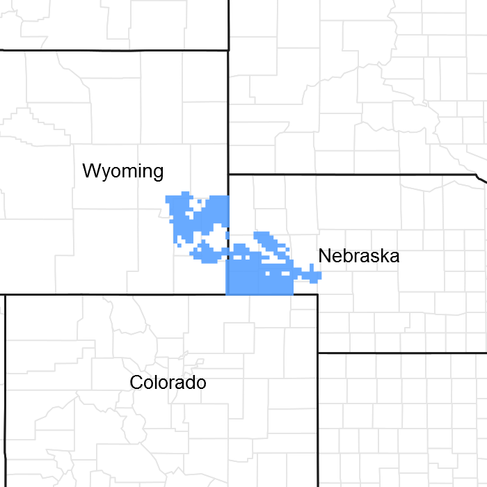
Figure 1. Mapped extent
Areas shown in blue indicate the maximum mapped extent of this ecological site. Other ecological sites likely occur within the highlighted areas. It is also possible for this ecological site to occur outside of highlighted areas if detailed soil survey has not been completed or recently updated.
Ecological site concept
This site has been combined with the Shallow Loamy ecological site, and re-named Shallow 12-17" PZ, (R07AY162WY)
Associated sites
| R067AY150WY |
Sandy (Sy) Sandy 12-17” P.Z. |
|---|---|
| R067AY176WY |
Very Shallow (VS) Very Shallow 12-17” P.Z. |
Similar sites
| R067AY176WY |
Very Shallow (VS) Very Shallow 12-17” P.Z. is less productive |
|---|---|
| R067AY150WY |
Sandy (Sy) Sandy 12-17” P.Z. is more productive |
| R067AY162WY |
Shallow (Sw) Shallow Loamy 12-17” P.Z. has more western wheatgrass, less needleandthread |
Table 1. Dominant plant species
| Tree |
Not specified |
|---|---|
| Shrub |
Not specified |
| Herbaceous |
Not specified |
Physiographic features
This site occurs on uplands, but will also occur on all landscape positions.
Table 2. Representative physiographic features
| Landforms |
(1)
Hill
(2) Ridge (3) Escarpment |
|---|---|
| Flooding frequency | None |
| Ponding frequency | None |
| Elevation | 4,000 – 6,500 ft |
| Slope | 50% |
| Ponding depth |
Not specified |
| Aspect | Aspect is not a significant factor |
Climatic features
Annual precipitation ranges from 12-17 inches per year. Wide fluctuations may occur in yearly precipitation and result in more dry years than those with more than normal precipitation. Temperatures show a wide range between summer and winter and between daily maximums and minimums, due to the high elevation and dry air, which permits rapid incoming and outgoing radiation. Cold air outbreaks from Canada in winter move rapidly from northwest to southeast and account for extreme minimum temperatures. Chinook winds may occur in winter and bring rapid rises in temperature. Extreme storms may occur during the winter, but most severely affect ranch operations during late winter and spring.
Wind speed averages about 8 mph, ranging from 10 mph during the spring to 7 mph during late summer. Daytime winds are generally stronger than nighttime and occasional strong storms may bring brief periods of high winds with gusts to more than 75 mph.
Growth of native cool-season plants begins about April 1 and continues to about July 1. Native warm-season plants begin growth about May 15 and continue to about August 15. Green up of cool season plants may occur in September and October of most years.
The following information is from the “Lusk 2SW” climate station.
Minimum Maximum
Frost-free period (days): 74 148
Freeze-free period (days): 101 181
Mean Annual Precipitation (inches): 12 17
Mean annual precipitation: 15.71 inches
Mean annual air temperature: 45.2 F (31.0 F Avg. Min. – 59.3 F Avg. Max.)
For detailed information visit the Natural Resources Conservation Service National Water and Climate Center at http://www.wcc.nrcs.usda.gov/ website. Other climate station(s) representative of this precipitation zone include: “Chugwater, Wheatland 4N, Cheyenne AP and Scottsbluff WSO AP”.
Table 3. Representative climatic features
| Frost-free period (average) | 148 days |
|---|---|
| Freeze-free period (average) | 181 days |
| Precipitation total (average) | 17 in |
Influencing water features
Soil features
The soils of this site are shallow (less than 20”to bedrock) well-drained soils formed in eolian deposits, alluvium over residuum or residuum. The soils have moderately rapid to rapid permeability and may occur on all slopes. The bedrock may be of any kind except igneous or volcanic and is virtually impenetrable to plant roots.
Major Soil Series correlated to this site include: Aberone, Blackhall, Brownrigg, Byrnie, Mcfadden, Peetz, Taluce, Tassel, Trelona, Treon
Other Soil Series correlated to this site include: none
Parent Material Kind: alluvium, eolian deposits, residuum
Parent Material Origin: sandstone
Surface Texture: loamy fine sand, loamy sand, fine sand, sand
Surface Texture Modifier: none
Subsurface Texture Group: sandy
Surface Fragments < 3” (% Cover): 0
Surface Fragments > 3” (%Cover): 0
Subsurface Fragments < 3” (% Volume): 0-10
Subsurface Fragments > 3” (% Volume): 0
Minimum Maximum
Drainage Class: well excessive
Permeability Class: rapid very rapid
Depth (inches): 10 20
Electrical Conductivity (mmhos/cm) <20”: 0 2
Sodium Absorption Ratio <20”: 0 0
Soil Reaction (1:1 Water) <20”: 6.6 7.8
Soil Reaction (0.1M CaCl2) <20”: N/A N/A
Available Water Capacity (inches): 0 5.0
Calcium Carbonate Equivalent (percent) <20”: 0 5
Table 4. Representative soil features
| Surface texture |
(1) Loamy fine sand (2) Loamy sand (3) Fine sand |
|---|---|
| Family particle size |
(1) Sandy |
| Drainage class | Well drained to excessively drained |
| Permeability class | Rapid to very rapid |
| Soil depth | 10 – 20 in |
| Surface fragment cover <=3" | Not specified |
| Surface fragment cover >3" | Not specified |
| Available water capacity (0-40in) |
5 in |
| Calcium carbonate equivalent (0-40in) |
5% |
| Electrical conductivity (0-40in) |
2 mmhos/cm |
| Sodium adsorption ratio (0-40in) |
Not specified |
| Soil reaction (1:1 water) (0-40in) |
6.6 – 7.8 |
| Subsurface fragment volume <=3" (Depth not specified) |
10% |
| Subsurface fragment volume >3" (Depth not specified) |
Not specified |
Ecological dynamics
Ecological Dynamics of the Site
As this site begins to deteriorate from a combination of frequent and severe grazing during the growing season, grasses such as little bluestem and sideoats grama will decrease in both frequency and production. Blue grama and threadleaf sedge will increase. Under continued frequent and severe defoliation, with no rest periods for the plants to recover, blue grama and threadleaf sedge will increase while needleandthread, rhizomatous wheatgrass, and prairie sandreed will begin to decrease. If continued, the plant community will become sod-bound, and all mid to tall grasses can eventually be removed from the plant community. Over the long-term, this continuous use in combination with high stock densities will result in a broken sod, with areas of bare ground developing, and species such as annual bromes and broom snakeweed invading.
The historic climax plant community (description follows the State and Transition Model Diagram) has been determined by study of rangeland relic areas, or areas protected from excessive disturbance. Trends in plant communities going from heavily grazed areas to lightly grazed areas, seasonal use pastures, and historical accounts have also been used.
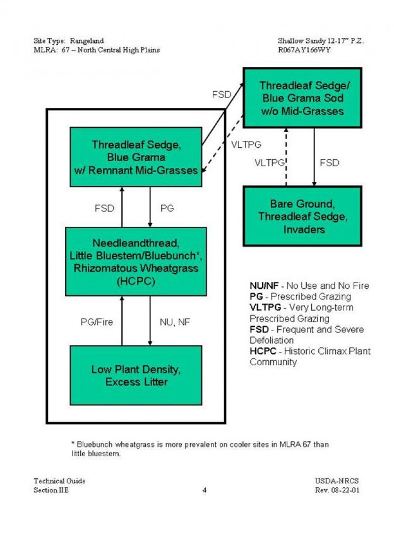
The following is a State and Transition Model Diagram that illustrates the common plant communities that can occur on the site and the transitions between these communities. The ecological processes will be discussed in more detail in the plant community narratives following the diagram.
State and transition model
More interactive model formats are also available.
View Interactive Models
More interactive model formats are also available.
View Interactive Models
Click on state and transition labels to scroll to the respective text
Ecosystem states
State 1 submodel, plant communities
State 2 submodel, plant communities
State 3 submodel, plant communities
State 4 submodel, plant communities
State 5 submodel, plant communities
State 1
Needleandthread, Little Bluestem/Bluebunch Wheatgrass, Rhizomatous Plant Community
Community 1.1
Needleandthread, Little Bluestem/Bluebunch Wheatgrass, Rhizomatous Plant Community
This is the interpretive plant community and is considered to be the Historic Climax Plant Community (HCPC). This plant community evolved with grazing by large herbivores and is well suited for grazing by domestic livestock and can be found on areas that are grazed and where the grazed plants receive adequate periods of rest during the growing season in order to recover. Historically, fires likely occurred infrequently. The potential vegetation is about 80-95% grasses or grass-like plants, 5-15% forbs, and 0-5% woody plants. Combinations of warm and cool-season mid-grasses dominate the plant community. The major grasses and grass-likes include needleandthread, little bluestem, rhizomatous wheatgrasses, threadleaf sedge, and blue grama. Other grasses include prairie sandreed, sideoats grama, and bluebunch wheatgrass. Bluebunch wheatgrass is found in Wyoming, primarily in the western portion of the 15-17” Precipitation Zone at higher elevations. Dominant forbs are prairie clovers, dotted gayfeather, hairy goldaster, fringed sagewort, buckwheats, and lemon scurfpea. Commonly found shrubs include yucca, winterfat, and pricklypear cactus. Skunkbush sumac and true mountainmahogany can also be found primarily on rock outcrops. In the 12 to 14 inch precipitation zone, the total annual production (air-dry weight) is about 900 pounds per acre during an average year, but it can range from about 600 pounds per acre in unfavorable years to about 1200 pounds per acre in above average years. In the 15 to 17 inch precipitation zone, the total annual production (air-dry weight) is about 1100 pounds per acre during an average year, but it can range from about 750 pounds per acre in unfavorable years to about 1500 pounds per acre in above average years. This plant community is well adapted to the Northern Great Plains climate. This is a sustainable plant community (soil stability, watershed function, and biologic integrity). Infiltration rates are moderate due to the rapid intake rate of the soils and the relatively steep topography. Soil erosion is low. Transitions or pathways leading to other plant communities are as follows: • Frequent and severe defoliation will move this plant community towards the Threadleaf Sedge, Blue Grama with Remnant Mid-grasses Plant Community. Over a period of years, plant species less tolerant to frequent or severe defoliation will begin to decrease, and those more tolerant will begin to increase. • No use and no fire will move this plant community towards the Low Plant Density, Excess Litter Plant Community. Initially, excess litter begins to build-up. Eventually native plant density begins to decrease and weeds and introduced species may begin to invade.
Figure 2. Annual production by plant type (representative values) or group (midpoint values)
Figure 3. Plant community growth curve (percent production by month). WY1104, 12-14SP upland sites w/ warm. 12-14" Precipitation Zone, Southern Plains (SP) with warm-season (grass) species.
| Jan | Feb | Mar | Apr | May | Jun | Jul | Aug | Sep | Oct | Nov | Dec |
|---|---|---|---|---|---|---|---|---|---|---|---|
| J | F | M | A | M | J | J | A | S | O | N | D |
| 0 | 0 | 0 | 5 | 20 | 35 | 30 | 5 | 5 | 0 | 0 | 0 |
State 2
Threadleaf Sedge, Blue Grama with Remnant Mid-Grasses Plant Community
Community 2.1
Threadleaf Sedge, Blue Grama with Remnant Mid-Grasses Plant Community
This plant community typically develops over a period of several years, under frequent and severe defoliation during the growing season of the mid-grasses. It typically is made up of sod-forming grasses with only remnants of mid-grasses remaining. Palatable forbs have been reduced. Compared to the HCPC, threadleaf sedge and blue grama have increased noticeably. Many of the mid-grasses have been reduced. If the plant community received adequate rest periods only during the early part of the growing season, the little bluestem, prairie sandreed, and sideoats grama will have been reduced. If the plant community received adequate rest periods only during the later part of the growing season, the rhizomatous wheatgrasses, bluebunch wheatgrass, and needleandthread will have been reduced. Significant forbs include cudweed sagewort, hairy goldaster, western ragweed, and slimflower scurfpea. Common shrubs include broom snakeweed, yucca, and pricklypear cactus. Plant diversity is moderate. In the 12 to 14 inch precipitation zone, the total annual production (air-dry weight) is about 700 pounds per acre during an average year, but it can range from about 450 pounds per acre in unfavorable years to about 950 pounds per acre in above average years. In the 15 to 17 inch precipitation zone, the total annual production (air-dry weight) is about 850 pounds per acre during an average year, but it can range from about 550 pounds per acre in unfavorable years to about 1,150 pounds per acre in above average years. Nearly all the plant species typically found in the HCPC are present and will respond to changes in grazing management. This plant community can become somewhat resistant to change, depending on how sod-bound the plant community has become. While soil erosion is low, infiltration has been reduced, and overland flow has been increased. This can result in off-site gully erosion. Transitions or pathways leading to other plant communities are as follows: • Frequent and severe defoliation will over time move this plant community toward the Threadleaf Sedge/Blue Grama Sod without Mid-grasses Plant Community. Plants less tolerant to grazing will decrease and those more tolerant to grazing will increase or invade. • Prescribed grazing will move this plant community towards the Needleandthread, Little Bluestem/Bluebunch, Rhizomatous Wheatgrass Plant Community (HCPC). If the community has become sod-bound, grazing land mechanical treatment (such as chiseling on the contour) could accelerate this transition by increasing infiltration and breaking up the sod. However, this may not be economically feasible due to shallow soils and low production potential.
Figure 4. Plant community growth curve (percent production by month). WY1104, 12-14SP upland sites w/ warm. 12-14" Precipitation Zone, Southern Plains (SP) with warm-season (grass) species.
| Jan | Feb | Mar | Apr | May | Jun | Jul | Aug | Sep | Oct | Nov | Dec |
|---|---|---|---|---|---|---|---|---|---|---|---|
| J | F | M | A | M | J | J | A | S | O | N | D |
| 0 | 0 | 0 | 5 | 20 | 35 | 30 | 5 | 5 | 0 | 0 | 0 |
State 3
Low Plant Density, Excess Litter Plant Community
Community 3.1
Low Plant Density, Excess Litter Plant Community
This plant community developed under the absence of grazing and fire. At first, excessive litter builds up shading out plants such as blue grama. Plants become decadent with low vigor. Bunch grasses, such as little bluestem and bluebunch wheatgrass, often develop dead centers. Eventually, the interspaces between the plants increase in size leaving more soil surface exposed. The dominant plants are similar to those found in the HCPC, but with less vigor. Annual weeds, cool-season grasses, and cactus typically have increased. Blue grama is reduced and western wheatgrass is increased. Noxious weeds such as Canada thistle, leafy spurge, and Dalmatian toadflax will invade, if a seed source is readily available. Kentucky bluegrass also tends to invade under these conditions. In the 12 to 14 inch precipitation zone, the total annual production (air-dry weight) is about 800 pounds per acre during an average year, but it can range from about 550 pounds per acre in unfavorable years to about 1,050 pounds per acre in above average years. In the 15 to 17 inch precipitation zone, the total annual production (air-dry weight) is about 1,000 pounds per acre during an average year, but it can range from about 650 pounds per acre in unfavorable years to about 1,350 pounds per acre in above average years. This plant community can be improved relatively quickly, if it has not been significantly eroded or invaded by noxious weeds. The introduction of grazing or fire will quickly move the plant community towards the HCPC. Soil erosion can become accelerated because of increased bare ground, if these conditions are allowed to continue over the long-term. Water flow patterns and pedestaling can become obvious. At that point, infiltration is reduced and runoff is increased. Transitions or pathways leading to other plant communities are as follows: • Prescribed grazing or fire will move this plant community towards the Needleandthread, Little Bluestem/Bluebunch, Rhizomatous Wheatgrass Plant Community (HCPC). This can occur relatively fast.
Figure 5. Plant community growth curve (percent production by month). WY1101, 12-14SP Upland sites w/o warm seasons. 12-14" Precipitation Zone, Southern Plains (SP) without warm season (grass) species.
| Jan | Feb | Mar | Apr | May | Jun | Jul | Aug | Sep | Oct | Nov | Dec |
|---|---|---|---|---|---|---|---|---|---|---|---|
| J | F | M | A | M | J | J | A | S | O | N | D |
| 0 | 0 | 0 | 5 | 25 | 40 | 15 | 5 | 10 | 0 | 0 | 0 |
State 4
Threadleaf Sedge/Blue Grama Sod without Mid-Grasses Plant Community
Community 4.1
Threadleaf Sedge/Blue Grama Sod without Mid-Grasses Plant Community
This plant community develops under long-term frequent and severe defoliation. This typically occurs when the community has been continuously grazed with heavy stocking rates, throughout the growing season over a period of many years. It is a dense sod made up of sedges and warm season grasses. The mid-grasses and palatable forbs have been nearly eliminated. Compared to the HCPC, threadleaf sedge and blue grama have greatly increased and now dominate. Little bluestem, sideoats grama, bluebunch wheatgrass, and needleandthread have been removed. Only remnants of rhizomatous wheatgrasses typically remain. Plant diversity is very low. In the 12 to 14 inch precipitation zone, the total annual production (air-dry weight) is about 550 pounds per acre during an average year, but it can range from about 350 pounds per acre in unfavorable years to about 750 pounds per acre in above average years. In the 15 to 17 inch precipitation zone, the total annual production (air-dry weight) is about 650 pounds per acre during an average year, but it can range from about 450 pounds per acre in unfavorable years to about 850 pounds per acre in above average years. Even with the best range management, this plant community is extremely resistant to change. This is due to the fact that many of the plant species are missing and a seed source is not readily available. Also, the sod-forming grasses tend to maintain themselves due to their resistance to any further overgrazing. If disturbed, it will usually return to a plant community very similar to that found prior to the treatment. The soil erosion is very low due to the sod-bound condition. Greatly reduced infiltration and increased runoff typically cause off-site gully erosion. This significantly reduces the amount of precipitation available for plant growth. Transitions or pathways leading to other plant communities are as follows: • Frequent and severe defoliation can move this plant community to a Bare Ground, Threadleaf sedge, Invaders Plant Community. • Very long-term prescribed grazing may eventually result in the Threadleaf Sedge, Blue Grama with Remnant Mid-Grasses Plant Community. This change may take generations depending on the availability of an adequate seed/vegetative source. Range or pasture planting may be the only option to return this community to a productive condition in a realistic time frame; however, this may not be economically feasible due to the shallowness of the soils and low production potential.
Figure 6. Plant community growth curve (percent production by month). WY1104, 12-14SP upland sites w/ warm. 12-14" Precipitation Zone, Southern Plains (SP) with warm-season (grass) species.
| Jan | Feb | Mar | Apr | May | Jun | Jul | Aug | Sep | Oct | Nov | Dec |
|---|---|---|---|---|---|---|---|---|---|---|---|
| J | F | M | A | M | J | J | A | S | O | N | D |
| 0 | 0 | 0 | 5 | 20 | 35 | 30 | 5 | 5 | 0 | 0 | 0 |
State 5
Bare Ground, Threadleaf sedge, Invaders Plant Community
Community 5.1
Bare Ground, Threadleaf sedge, Invaders Plant Community
This plant community occurs where the rangeland is grazed year-round, at high stock densities. Physical impact such as trampling, soil compaction, and trailing typically contribute to this transition. The plant composition is made of annuals with a few species of perennial forbs and grasses that are very tolerant to frequent and severe defoliation. The dominant perennial grasses and grass-likes include threadleaf sedge, blue grama, and threeawns. Annual grasses such as cheatgrass and sixweeks fescue have increased. The dominant forbs include curlycup gumweed, phlox, sandwort, hairy goldaster, green sagewort, and annuals. Broom snakeweed, yucca, and pricklypear cactus are increasing. Compared to the Historic Climax Plant Community, all perennial plants have been greatly reduced with only remnants of the most grazing tolerant species present. Plant diversity is very low if annuals and weedy species are not considered. In the 12 to 14 inch precipitation zone, the total annual production (air-dry weight) is about 450 pounds per acre during an average year, but it can range from about 300 pounds per acre in unfavorable years to about 600 pounds per acre in above average years. In the 15 to 17 inch precipitation zone, the total annual production (air-dry weight) is about 550 pounds per acre during an average year, but it can range from about 350 pounds per acre in unfavorable years to about 750 pounds per acre in above average years. This plant community is very resistant to change. Even with the best range management, this plant community may never return to the HCPC. If disturbed, it will usually return to the plant community found prior to the treatment, sometimes only affecting production for a short time. Soil erosion can be highly variable depending on the amount of ground cover. Typically there is a large amount of bare ground unless covered by annuals. Typically, runoff is high and infiltration is low. Transitions or pathways leading to other plant communities are as follows: • Very long-term prescribed grazing will move this plant community toward the Threadleaf Sedge/Blue Grama Sod without Mid-Grasses Plant Community over many years. Range or pasture planting may be the only option to return this community to a productive condition in a realistic time frame; however, this may not be economically feasible due to shallow soils and low production potential.
Figure 7. Plant community growth curve (percent production by month). WY1101, 12-14SP Upland sites w/o warm seasons. 12-14" Precipitation Zone, Southern Plains (SP) without warm season (grass) species.
| Jan | Feb | Mar | Apr | May | Jun | Jul | Aug | Sep | Oct | Nov | Dec |
|---|---|---|---|---|---|---|---|---|---|---|---|
| J | F | M | A | M | J | J | A | S | O | N | D |
| 0 | 0 | 0 | 5 | 25 | 40 | 15 | 5 | 10 | 0 | 0 | 0 |
Additional community tables
Table 5. Community 1.1 plant community composition
| Group | Common name | Symbol | Scientific name | Annual production (lb/acre) | Foliar cover (%) | |
|---|---|---|---|---|---|---|
|
Grass/Grasslike
|
||||||
| 1 | 12-14" | 135–360 | ||||
| little bluestem | SCSC | Schizachyrium scoparium | 90–180 | – | ||
| sideoats grama | BOCU | Bouteloua curtipendula | 0–90 | – | ||
| prairie sandreed | CALO | Calamovilfa longifolia | 45–90 | – | ||
| 2 | 12-14" | 135–270 | ||||
| needle and thread | HECO26 | Hesperostipa comata | 135–225 | – | ||
| bluebunch wheatgrass | PSSP6 | Pseudoroegneria spicata | 0–90 | – | ||
| 3 | 12-14" | 90–135 | ||||
| blue grama | BOGR2 | Bouteloua gracilis | 90–135 | – | ||
| 4 | 12-14" | 90–135 | ||||
| thickspike wheatgrass | ELLA3 | Elymus lanceolatus | 45–135 | – | ||
| western wheatgrass | PASM | Pascopyrum smithii | 45–135 | – | ||
| 5 | 12-14" | 45–90 | ||||
| Grass, perennial | 2GP | Grass, perennial | 0–45 | – | ||
| Indian ricegrass | ACHY | Achnatherum hymenoides | 0–45 | – | ||
| sand bluestem | ANHA | Andropogon hallii | 0–45 | – | ||
| threeawn | ARIST | Aristida | 0–45 | – | ||
| hairy grama | BOHI2 | Bouteloua hirsuta | 0–45 | – | ||
| prairie Junegrass | KOMA | Koeleria macrantha | 0–45 | – | ||
| plains muhly | MUCU3 | Muhlenbergia cuspidata | 0–45 | – | ||
| Sandberg bluegrass | POSE | Poa secunda | 0–45 | – | ||
| sand dropseed | SPCR | Sporobolus cryptandrus | 0–45 | – | ||
| 6 | 12-14" | 45–135 | ||||
| threadleaf sedge | CAFI | Carex filifolia | 45–135 | – | ||
| sedge | CAREX | Carex | 0–45 | – | ||
| 9 | 15-17" | 165–440 | ||||
| little bluestem | SCSC | Schizachyrium scoparium | 110–220 | – | ||
| sideoats grama | BOCU | Bouteloua curtipendula | 0–110 | – | ||
| prairie sandreed | CALO | Calamovilfa longifolia | 55–110 | – | ||
| 10 | 15-17" | 165–230 | ||||
| needle and thread | HECO26 | Hesperostipa comata | 165–275 | – | ||
| bluebunch wheatgrass | PSSP6 | Pseudoroegneria spicata | 0–110 | – | ||
| 11 | 15-17" | 110–165 | ||||
| blue grama | BOGR2 | Bouteloua gracilis | 110–165 | – | ||
| 12 | 15-17" | 110–165 | ||||
| thickspike wheatgrass | ELLA3 | Elymus lanceolatus | 55–165 | – | ||
| western wheatgrass | PASM | Pascopyrum smithii | 55–165 | – | ||
| 13 | 15-17" | 55–110 | ||||
| Grass, perennial | 2GP | Grass, perennial | 0–55 | – | ||
| Indian ricegrass | ACHY | Achnatherum hymenoides | 0–55 | – | ||
| sand bluestem | ANHA | Andropogon hallii | 0–55 | – | ||
| threeawn | ARIST | Aristida | 0–55 | – | ||
| hairy grama | BOHI2 | Bouteloua hirsuta | 0–55 | – | ||
| prairie Junegrass | KOMA | Koeleria macrantha | 0–55 | – | ||
| plains muhly | MUCU3 | Muhlenbergia cuspidata | 0–55 | – | ||
| Sandberg bluegrass | POSE | Poa secunda | 0–55 | – | ||
| sand dropseed | SPCR | Sporobolus cryptandrus | 0–55 | – | ||
| 14 | 15-17" | 55–165 | ||||
| threadleaf sedge | CAFI | Carex filifolia | 55–165 | – | ||
| sedge | CAREX | Carex | 0–55 | – | ||
|
Forb
|
||||||
| 7 | 12-14" | 45–135 | ||||
| Forb, perennial | 2FP | Forb, perennial | 0–45 | – | ||
| Cuman ragweed | AMPS | Ambrosia psilostachya | 0–45 | – | ||
| field sagewort | ARCA12 | Artemisia campestris | 0–45 | – | ||
| prairie sagewort | ARFR4 | Artemisia frigida | 0–45 | – | ||
| white sagebrush | ARLU | Artemisia ludoviciana | 0–45 | – | ||
| milkvetch | ASTRA | Astragalus | 0–45 | – | ||
| prairie clover | DALEA | Dalea | 0–45 | – | ||
| buckwheat | ERIOG | Eriogonum | 0–45 | – | ||
| scarlet beeblossom | GACO5 | Gaura coccinea | 0–45 | – | ||
| hairy false goldenaster | HEVI4 | Heterotheca villosa | 0–45 | – | ||
| dotted blazing star | LIPU | Liatris punctata | 0–45 | – | ||
| beardtongue | PENST | Penstemon | 0–45 | – | ||
| lemon scurfpea | PSLA3 | Psoralidium lanceolatum | 0–45 | – | ||
| ragwort | SENEC | Senecio | 0–45 | – | ||
| scarlet globemallow | SPCO | Sphaeralcea coccinea | 0–45 | – | ||
| white heath aster | SYER | Symphyotrichum ericoides | 0–45 | – | ||
| 15 | 15-17" | 55–165 | ||||
| Forb, perennial | 2FP | Forb, perennial | 0–55 | – | ||
| Cuman ragweed | AMPS | Ambrosia psilostachya | 0–55 | – | ||
| field sagewort | ARCA12 | Artemisia campestris | 0–55 | – | ||
| prairie sagewort | ARFR4 | Artemisia frigida | 0–55 | – | ||
| white sagebrush | ARLU | Artemisia ludoviciana | 0–55 | – | ||
| milkvetch | ASTRA | Astragalus | 0–55 | – | ||
| prairie clover | DALEA | Dalea | 0–55 | – | ||
| buckwheat | ERIOG | Eriogonum | 0–55 | – | ||
| scarlet beeblossom | GACO5 | Gaura coccinea | 0–55 | – | ||
| hairy false goldenaster | HEVI4 | Heterotheca villosa | 0–55 | – | ||
| dotted blazing star | LIPU | Liatris punctata | 0–55 | – | ||
| beardtongue | PENST | Penstemon | 0–55 | – | ||
| lemon scurfpea | PSLA3 | Psoralidium lanceolatum | 0–55 | – | ||
| ragwort | SENEC | Senecio | 0–55 | – | ||
| scarlet globemallow | SPCO | Sphaeralcea coccinea | 0–55 | – | ||
| white heath aster | SYERE | Symphyotrichum ericoides var. ericoides | 0–55 | – | ||
|
Shrub/Vine
|
||||||
| 8 | 12-14" | 0–45 | ||||
| Shrub (>.5m) | 2SHRUB | Shrub (>.5m) | 0–45 | – | ||
| alderleaf mountain mahogany | CEMO2 | Cercocarpus montanus | 0–45 | – | ||
| broom snakeweed | GUSA2 | Gutierrezia sarothrae | 0–45 | – | ||
| winterfat | KRLA2 | Krascheninnikovia lanata | 0–45 | – | ||
| skunkbush sumac | RHTR | Rhus trilobata | 0–45 | – | ||
| soapweed yucca | YUGL | Yucca glauca | 0–45 | – | ||
| plains pricklypear | OPPO | Opuntia polyacantha | 0–18 | – | ||
| 16 | 15-17" | 0–55 | ||||
| Shrub (>.5m) | 2SHRUB | Shrub (>.5m) | 0–55 | – | ||
| alderleaf mountain mahogany | CEMO2 | Cercocarpus montanus | 0–55 | – | ||
| winterfat | KRLA2 | Krascheninnikovia lanata | 0–55 | – | ||
| skunkbush sumac | RHTR | Rhus trilobata | 0–55 | – | ||
| soapweed yucca | YUGL | Yucca glauca | 0–55 | – | ||
| plains pricklypear | OPPO | Opuntia polyacantha | 0–22 | – | ||
| broom snakeweed | GUSA2 | Gutierrezia sarothrae | 0–22 | – | ||
Table 6. Community 5.1 plant community composition
| Group | Common name | Symbol | Scientific name | Annual production (lb/acre) | Foliar cover (%) |
|---|
Interpretations
Animal community
Animal Community – Wildlife Interpretations
Needleandthread, Little bluestem/Bluebunch, Rhizomatous Wheatgrasses Community (HCPC): The predominance of grasses plus high forb diversity in this community favors large grazers such as pronghorn and elk. Suitable thermal and escape cover for mule deer is limited due to low shrub cover. White-tailed and black-tailed jackrabbit, badger, and coyote commonly use this community. This community also provides habitat for a wide array of smaller mammals, so diverse prey populations are available for raptors such as ferruginous and Swainson’s hawks. Birds such as western kingbird, western meadowlark, lark bunting, and grasshopper sparrow will utilize this community for nesting and foraging.
Threadleaf Sedge, Blue Grama w/ Remnant Mid-grasses Community: The reduction in taller grasses in this community results in decreased use by lark buntings and western meadowlarks. Use by long-billed curlew increases, provided there is standing water within ¼ mile. Killdeer, horned larks, and McCown’s longspurs will also make significant use of this community. Pronghorn may forage in this community.
Threadleaf Sedge, Blue Grama Sod w/o Mid-grasses Community: This community provides limited foraging for antelope and other grazers. Ground-nesting birds favoring sparse vegetation may use this community. Long-billed curlews will use this community if standing water is present within ¼ mile. Generally, this is not a target vegetative community for wildlife habitat management.
Bare Ground, Threadleaf Sedge, Invaders Community: Sparse vegetation and greater amounts of bare ground provide suitable habitat for prairie dogs, horned larks and McCown’s longspurs. However, a lack of complex vegetation structure and residual cover makes this community poor habitat in general for most ground-nesting birds and big game species.
Low Plant Density, Excess Litter Community: This community has low habitat value for most wildlife species. Horned larks may nest in this community.
Animal Community – Grazing Interpretations
The following tables list suggested initial stocking rates for cattle under continuous grazing (year long grazing or growing season long grazing) under normal growing conditions; however, continuous grazing is not typically recommended. These are conservative estimates that should be used only as guidelines in the initial stages of the conservation planning process. Often, the current plant composition does not entirely match any particular plant community as described in this ecological site description. Because of this, a field visit is recommended, in all cases, to document plant composition and production. More precise carrying capacity estimates should eventually be calculated using the following stocking rate information along with animal preference data, particularly when grazers other than cattle are involved. Under more intensive grazing management, improved harvest efficiencies can result in an increased carrying capacity.
Plant Community Production Carrying
12-14” Precipitation Capacity
(lbs./acre) (AUM/acre)
Needleandthread, Little Bluestem/Bluebunch, Rhiz. Wheatgrass (HCPC) 900 0.30
Threadleaf Sedge, Blue Grama w/ Remnant Mid-Grasses 700 0.22
Threadleaf Sedge/Blue Grama Sod w/o Mid-Grasses 550 0.17
Bare Ground, Threadleaf Sedge, Invaders 450 0.10
Low Plant Density, Excess Litter 800 0.25
Plant Community Production Carrying
15-17” Precipitation Capacity (lbs./acre) (AUM/acre)
Needleandthread, Little Bluestem/Bluebunch, Rhiz. Wheatgrass (HCPC) 1100 0.35
Threadleaf Sedge, Blue Grama w/ Remnant Mid-Grasses 850 0.27
Threadleaf Sedge/Blue Grama Sod w/o Mid-Grasses 650 0.20
Bare Ground, Threadleaf Sedge, Invaders 550 0.15
Low Plant Density, Excess Litter 1000 0.30
Grazing by domestic livestock is one of the major income-producing industries in the area. Rangelands in this area provide yearlong forage under prescribed grazing for cattle, sheep, horses and other herbivores. During the dormant period, livestock may need supplementation based on reliable forage analysis.
Hydrological functions
Water is the principal factor limiting forage production on this site. This site is dominated by soils in hydrologic group B and C. Infiltration ranges from rapid to very rapid. Runoff potential for this site varies from low to moderate depending on soil hydrologic group and ground cover. In many cases, areas with greater than 75% ground cover have the greatest potential for high infiltration and lower runoff. An example of an exception would be where short-grasses form a strong sod and dominate the site. Areas where ground cover is less than 50% have the greatest potential to have reduced infiltration and higher runoff (refer to Part 630, NRCS National Engineering Handbook for detailed hydrology information).
Exposed areas of sandstone are inherent to this site. Where slopes are gentle, water flow paths should be broken, irregular in appearance or discontinuous with numerous debris dams or vegetative barriers and exhibit slight to no evidence of rills, wind scoured areas or pedestaled plants. As slopes become steep and bare areas increase, expect to find evidence of wind scouring, water flow patterns, and pedestaled plants. Sub-surface soil layers, where not affected by bedrock, are non-restrictive to water movement and root penetration.
Recreational uses
This site provides hunting, hiking, photography, bird watching and other opportunities. The wide varieties of plants that bloom from spring until fall have an esthetic value that appeals to visitors.
Wood products
No appreciable wood products are present on the site.
Other products
None noted.
Supporting information
Inventory data references
Inventory Data References (narrative)
Information presented here has been derived from NRCS clipping data and other inventory data. Field observations from range trained personnel was also used.
Inventory Data References
Data Source Number of Records Sample Period State County
SCS-RANGE-417 110 1963 -1987 WY Platte & others
Other references
Other sources used as references include: High Plains Regional Climate Center, USDA NRCS Water and Climate Center, USDA NRCS National Range and Pasture Handbook, and USDA NRCS Soil Surveys from various counties.
Contributors
C. Ring
Rangeland health reference sheet
Interpreting Indicators of Rangeland Health is a qualitative assessment protocol used to determine ecosystem condition based on benchmark characteristics described in the Reference Sheet. A suite of 17 (or more) indicators are typically considered in an assessment. The ecological site(s) representative of an assessment location must be known prior to applying the protocol and must be verified based on soils and climate. Current plant community cannot be used to identify the ecological site.
| Author(s)/participant(s) | |
|---|---|
| Contact for lead author | |
| Date | 01/01/2005 |
| Approved by | E. Bainter |
| Approval date | |
| Composition (Indicators 10 and 12) based on | Annual Production |
Indicators
-
Number and extent of rills:
Rills should not be present -
Presence of water flow patterns:
Barely observable -
Number and height of erosional pedestals or terracettes:
Essentially non-existent -
Bare ground from Ecological Site Description or other studies (rock, litter, lichen, moss, plant canopy are not bare ground):
Bare ground is 40-60% occurring in small areas throughout site -
Number of gullies and erosion associated with gullies:
Active gullies should be restricted to areas of concentrated water flow patterns on steeper slopes -
Extent of wind scoured, blowouts and/or depositional areas:
Small scoured sites may be observed -
Amount of litter movement (describe size and distance expected to travel):
Litter movement is little to none based on topography and water flow patterns -
Soil surface (top few mm) resistance to erosion (stability values are averages - most sites will show a range of values):
Plant cover and litter is at 50% or greater of soil surface and maintains soil surface integrity. Soil Stability class is anticipated to be 3 or greater. -
Soil surface structure and SOM content (include type of structure and A-horizon color and thickness):
Use Soil Series description for depth and color of A-horizon -
Effect of community phase composition (relative proportion of different functional groups) and spatial distribution on infiltration and runoff:
Grass canopy and basal cover should reduce raindrop impact and slow overland flow providing increased time for infiltration to occur. Infiltration is rapid to very rapid -
Presence and thickness of compaction layer (usually none; describe soil profile features which may be mistaken for compaction on this site):
No compaction layer or soil surface crusting should be present. -
Functional/Structural Groups (list in order of descending dominance by above-ground annual-production or live foliar cover using symbols: >>, >, = to indicate much greater than, greater than, and equal to):
Dominant:
Sub-dominant:
Other:
Additional:
Mid stature Warm Season Grasses = Mid Stature Cool Season Grasses > Short Grasses/Grasslikes > Forbs > Shrubs -
Amount of plant mortality and decadence (include which functional groups are expected to show mortality or decadence):
Very Low -
Average percent litter cover (%) and depth ( in):
Average litter cover is 15-25% with depths of 0.25 to 0.5 inches -
Expected annual annual-production (this is TOTAL above-ground annual-production, not just forage annual-production):
12”-14” Precipitation Zone = 900 lbs/ac 15”-17” Precipitation Zone = 1100 lbs/ac -
Potential invasive (including noxious) species (native and non-native). List species which BOTH characterize degraded states and have the potential to become a dominant or co-dominant species on the ecological site if their future establishment and growth is not actively controlled by management interventions. Species that become dominant for only one to several years (e.g., short-term response to drought or wildfire) are not invasive plants. Note that unlike other indicators, we are describing what is NOT expected in the reference state for the ecological site:
Blue grama, Threadleaf sedge, Prickly Pear, Broom Snakeweed, Yucca, and Species found on Noxious Weed List -
Perennial plant reproductive capability:
All species are capable of reproducing
Print Options
Sections
Font
Other
The Ecosystem Dynamics Interpretive Tool is an information system framework developed by the USDA-ARS Jornada Experimental Range, USDA Natural Resources Conservation Service, and New Mexico State University.
Click on box and path labels to scroll to the respective text.