Ecological dynamics
Plant tables have not been developed for this site. Until such time as they can be updated, use the plant tables in the referenced literature that correlates to this concept (refer to plant tables from legacy sites later in this section). With respect to the imperfect alignment of such correlations, be aware of these shortcomings in their applicability to conservation planning.
The Limy Escarpments ecological site is often dominated by warm-season grasses (mostly short- and mid-grasses), but also contains a mix of shrubs, forbs, succulents, and trees. New Mexico feathergrass is the one cool-season grass species that appears capable of achieving codominance here. As is typical of plant communities in this region, pronounced annual variations in precipitation translate to considerable short-term fluctuations in annual production within a given plant community phase.
There are numerous variables which affect the range of characteristics for this ecological site. Variables such as elevation, latitude, and orographic effects create a climatic gradient which influence the distribution of C3 and C4 plants. Soil properties such as surface texture, depth to and type of bedrock, parent material, and slope landform position affect the composition of plants. Natural disturbances such as drought and wildfire affect species density and cover.
The climate gradient across the CP LRU shows a greater distribution of C3 plants such as western wheatgrass and bottlebrush squirreltail where temperatures are cooler, and moisture is more abundant. Species such as hairy grama, Hall’s panicum, and yellow Indiangrass are much more common at lower elevations and more eastern longitudes.
Within this site, the dominant species of short grasses are inherently drought- and grazing-tolerant (Lauenroth, 1994). Across the western parts of the U.S., blue grama is one of the most extensively distributed grasses and occurs in a wide variety of different ecosites ranging from grasslands to shrubland and woodland sites. This grass evolved with grazing by large herbivores and, when grazed continuously, tends to form a short sod. When allowed to grow under lower grazing pressures, the plants develop the upright physiognomy of a bunchgrass. If blue grama is eliminated from an area by extended drought (3 to4 years) or disturbance such as plowing, regeneration is slow because of very slow tillering rates (Samuel, 1985), low and variable seed production, minimal seed storage in the soil (Coffin, 1989) and limited seedling germination and establishment due to particular temperature and extended soil moisture requirements for successful seedling establishment (Hyder, 1971) (Briske, 1978). Buffalograss, which is more abundant at warmer, lower elevations of this site, is often found occupying swale or depression positions across the landscape. Buffalograss is less drought-tolerant than blue grama but re-establishes more quickly following disturbance due to higher seed abundance and viability and more effective above-ground tillering (Peters, 2008).
Large-scale processes such as climate, fire and grazing influence this site. During years with favorable growing seasons, the effects of grazing may be mitigated. During years of low precipitation, grazing can magnify degradation of the site (Milchunas D.G., 1989). Fire is a natural disturbance regime that suppresses succulents and shrubs while stimulating grasses and forbs, however, in contrast to mid-grass and tall-grass prairie sites, fire is less important (Wright, 1982). This is because the drier conditions produce less vegetation/fuel load, lowering the relative fire frequency. However, historically, fires that did occur were often very expansive, especially after a series of years where above average precipitation built enough litter/fine fuels. Currently, fire suppression and more extensive grazing in the region have decreased the fire frequency, and it is unlikely that these processes could occur at a natural scale (USNVC, 2017)-G144. According to (Gebow, 2001), fire effects in the same location will vary, especially with fire timing, where seasonality can either hinder or benefit plants depending on their growing stage. Precipitation events occurring before and after fire will also influence the recovery of plants. Fire promotes rhizomatous plant species, such as western wheatgrass, that can take advantage of below-ground rhizomes from which tillering is rapidly initiated.
Grazing pressure will tend to favor grasses such as blue grama, galleta, and purple threeawn; shrubs such as broom snakeweed and prairie sagewort; and tree species such as oneseed juniper and twoneedle pinyon.
As noted in the Representative Soil Features section, there is no apparent correlation between readily-observable dynamic soil properties and ecological state on this site. Rather, the plant communities are the best indicators of an area’s position on the state and transition model.
Correlation to Legacy Information:
From the Hills (R070AY014NM) ESD – currently correlated to one of the Penrose variant components:
Historic Climax Plant Community -The site is a grassland with an aspect dominance of pinyon-juniper with an understory of grasses, forbs and browse. Approximately 50 percent of the total vegetative production are made up of grasses. Grass species are dominated by warm-season mid-grasses. Woody species make up approximately 35 percent of the vegetative production. A variety of perennial and annual forbs make up approximately 10 percent of the vegetative production. North and east facing slopes typically produce a denser vegetative cover and produce more vegetative growth than the south or west facing slopes
The following information comes from initial soil survey manuscripts that correlates to the Limy Escarpments ecological site. Note that there is not a 1:1 relationship between the Limy Escarpments site and these legacy ecological site concepts. Much of the ecological information from the manuscripts is tied to a single component rather than to entire escarpment complexes. While Shale Breaks was correlated to multiple soil series/components on escarpments, current linework suggests that initial soil surveyors had different geomorphic concepts than those applied to the Limy Escarpments site.
The Laporte component of the Limy Escarpments is currently correlated to the Loamy (R077BY033NM) site, which was designed in another MLRA. The two Penrose variant components are correlated to different sites: Hills (R070AY014NM) and Shallow Upland (R070AY003NM); it is unclear why they these components were assigned different ecological sites, as they are nearly identical. Of the three, Hills comes closest to characterizing the plants, soils, and physiography of this site. However, it doesn’t take into account the ecological differences between soils with accumulated carbonate salts in the profile from soils that do not.
From Hills (R070AY014NM) Tables
Annual production by plant type
Plant Type---------Low(Lb/Acre)---------Representative Value(Lb/Acre)---------High(Lb/Acre)
Grass/Grasslike---------212---------------------------557------------------------------------901
Shrub/Vine--------------132---------------------------347------------------------------------561
Forb-------------------------32-----------------------------84-------------------------------------136
Total-----------------------376---------------------------988------------------------------------1598
Community 1.1 plant community composition
Common Name------------Symbol--------Scientific Name-----------Annual Production (Lb/Acre)
GRASS/GRASSLIKE
1 blue grama---------------BOGR2---------Bouteloua gracilis------------------158–218
2 hairy grama---------------BOHI2---------Bouteloua hirsuta-------------------158–218
3 little bluestem-----------SCSC----------Schizachyrium scoparium-----------105–158
3 mountain muhly---------MUMO---------Muhlenbergia montana-----------32–53
4 sideoats grama-----------BOCU----------Bouteloua curtipendula------------53–105
5 big bluestem--------------ANGE---------Andropogon gerardii----------------21–53
6 common wolfstail--------LYPH----------Lycurus phleoides--------------------21–53
7 James' galleta-------------PLJA-----------Pleuraphis jamesii-------------------21–53
8 Graminoid (grass or grass-like)-2GRAM-Graminoid (grass or grass-like)---21–53
FORB
9 buckwheat-----------------ERIOG---------Eriogonum-----------------------------21–32
10 Forb, annual--------------2FA------------Forb, annual---------------------------53–105
Forb, perennial --------------2FP-------------Forb, perennial-----------------------53–105
SHRUB/VINE
11 juniper----------------------JUNIP---------Juniperus-----------------------------105–158
12 twoneedle pinyon---------PIED---------Pinus edulis---------------------------53–105
13 oak---------------------------QUERC-------Quercus-------------------------------105–158
14 hairy mountain mahogany-CEMOP-Cercocarpus montanus var. paucidentatus-53–74
15 skunkbush sumac----------RHTR---------Rhus trilobata-------------------------21–53
16 Shrub, deciduous-----------2SD----------Shrub, deciduous---------------------32–53
From the San Miguel County (NM630) manuscript:
The potential natural plant community* of the Penrose soil is mainly true mountain mahogany, blue grama, needlegrass, and little bluestem(…) As the range deteriorates, the proportion of desirable forage plants decreases and the proportion of ring muhly, galleta, pricklypear, and oneseed juniper increases. Grazing management should be designed to increase the production and reproduction of sideoats grama, western wheatgrass, and little bluestem.
*This manuscript plant information appears to fit this ecological site better than the currently correlated site. However, based on our observations, mountain mahogany does not occur on most escarpments.
Adapted from the Rangeland Productivity table in the NM630 Manuscript:
Penrose component of map unit ME (correlated here to the “Shale Breaks” range site) -- The approximate species composition of the potential plant community is as follows:
Blue Grama-----------------------------------------------30
Sideoats grama-----------------------------------------15
Needlegrass*---------------------------------------------10
Juniper------------------------------------------------------10
Little bluestem--------------------------------------------5
Indian ricegrass-------------------------------------------5
Total production in pounds per acre for unfavorable, normal, and favorable years: 400, 700, 1,000
*“Needlegrass” most likely refers to New Mexico feathergrass here.
Adapted from the Rangeland Productivity table in the NM630 Manuscript:
Mion component of map unit ME (correlated here to the “Shale Breaks” range site) -- The approximate species composition of the potential plant community is as follows:
Sideoats grama----------------------------------------20
Little bluestem-----------------------------------------20
Blue Grama----------------------------------------------20
Needleandthread*------------------------------------15
New Mexico feathergrass-------------------------10
Wolftail-----------------------------------------------------5
Red threeawn--------------------------------------------5
*Needleandthread has not been observed on the Limy Escarpments site.
From the Mora County (NM638) manuscript:
The potential natural plant community on the Mion soil component is mainly blue grama, sideoats grama, and little bluestem. The potential natural plant community of the Penrose Variant soil is mainly sideoats grama, blue grama, little bluestem, and New Mexico feathergrass. As the potential natural plant community deteriorates, little bluestem, sideoats grama, and New Mexico feathergrass decrease and there is an increase in ring muhly, threeawn, and broom snakeweed, which normally occur in small amounts in the potential natural plant community. Grazing management should be designed to increase the vigor, productivity, and reproduction of New Mexico feathergrass, little bluestem, and sideoats grama.
From the Colfax County (NM007) manuscript description of the Laporte series:
The vegetation is pinyon pine, oneseed juniper, and Gambel oak and an understory of blue grama, sideoats grama, and little bluestem.
From the Colfax County (NM007) manuscript description of the Mion series:
The vegetation is sideoats grama, fringed sagewort, yucca, pinyon pine, and one-seed juniper.
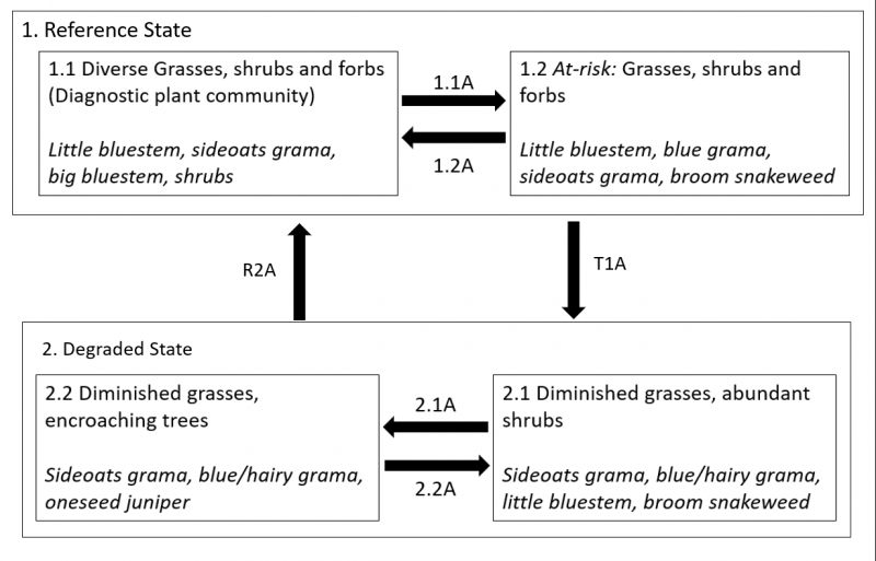
State 1
Reference State
This state exists where the effects of grazing pressure are less pronounced. The two most obvious variables that distinguish States 1 and 2 are the annual production and species composition of grasses. Since topsoils are characteristically thin and soil profiles are generally protected from erosion by surface fragments, thickness of topsoil is not a reliable indicator of state or community phase.
While trees can be found on all states and phases of this site, they are generally confined to the uppermost portions of the escarpment in State 1. Significant encroachment of trees onto the lower escarpment (where limestone bedrock does not control soil depth) only occurs in State 2.
Community 1.1
Diverse grasses, shrubs and forbs (diagnostic plant community)
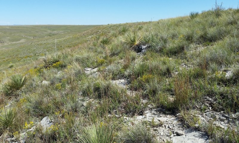
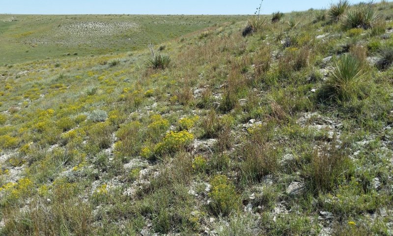
Figure 8. Community phase 1.1 on the upper third of an escarpment, Colfax County, September 2018. Soil here is very shallow (< 25 cm to root-restrictive, limestone bedrock). Note the rock outcrop in the foreground.
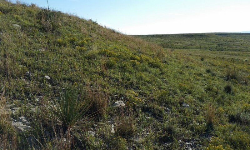
Figure 9. Phase 1.1 on the lower third of an escarpment, Colfax County, September 2018. Soil here is 74 cm deep to root-restrictive, weathered shale. As in Figure 7 above, grasses here are thriving in spite of considerable shrub cover.
This community is dominated by grasses, but contains a number of forb species, along with a considerable amount of shrubs (generally less than 10 percent cover). Foliar cover ranges from 45 to 80 percent. Total canopy cover of warm season grasses is between 30 and 50 percent, and cool-season grass cover can be as high as 10 percent. Forbs and shrubs can each account for up to 10 percent cover. Annual production averages around 850 pounds per acre, but can range between 600 and 1,100, depending mostly on annual weather patterns. Cool-season grasses, particularly New Mexico feathergrass, are much more abundant on the limestone-dominated soils on the upper slopes. Tallgrasses (big bluestem and yellow Indiangrass) are most abundant on steeper slopes, perhaps because cattle tend to avoid such terrain.
This community exists where season-long grazing has not occurred in a number of years, and where tallgrass species have not been extirpated. Little bluestem is typically the dominant grass, but sideoats grama and New Mexico feathergrass are often codominant. While forbs represent a small percentage of foliar cover, their species richness is quite high—leading to colorful displays following major rain events. Shrubs are always present, and are often a considerable component. Broom snakeweed, Bigelow sagebrush, and plains yucca are the most common species. While tree species (particularly oneseed juniper) often inhabit shallow limestone soils on the upper escarpment, they are notable absent from the deeper soils below. It is not clear whether periodic fire, the vigor of grasses, or some combination of these two suppresses tree encroachment. Since considerable understory biomass is needed to produce a stand-killing fire, it stands to reason that grass vigor and fire frequency are covariate.
It should be note that this community phase has been observed in large pastures where short-duration grazing has not been actively implemented, but recent stocking rates were low. Herbivory by cattle was quite evident on flatter terrain nearby. Thus, the apparent lack of prolonged grazing in this community phase of Limy Escarpments thought to be, in part, a function of cattle behavior.
This plant community optimizes energy flow, hydrologic function, and nutrient cycling. The diverse root systems take advantage of moisture from both close to the surface as well as deeper in the soil profile. High canopy cover, in concert with surface fragments, protects the soil surface from raindrop impact; fibrous roots of grasses and good soil structure also promote infiltration of rainwater and prevent erosion. With periodic herbivory and fire, decomposition is active, creating soil organic matter, which enhances “plant available water” needed for plant vigor.
Community 1.2
At-risk: Grasses, shrubs and forbs
This community is dominated by grasses, but contains a number of forb species, along with a considerable amount of shrubs (generally less than 10 percent cover). Foliar cover ranges from 30 to 70 percent. Total canopy cover of warm season grasses is between 30 and 60 percent. Cool-season grass cover is generally under 5 percent. Forbs and shrubs can each account for up to 10 and 15 percent cover, respectively. Annual production averages around 800 pounds per acre, but can range between 600 and 1,000 pounds per acre, depending mostly on annual weather patterns. Cool-season grasses, particularly New Mexico feathergrass, are much more abundant on the limestone-dominated soils on the upper slopes.
This community exists where season-long grazing has occurred in recent years. Little bluestem, sideoats grama, and blue grama are the dominant grass species. Big bluestem and yellow Indiangrass are either quite sparse or entirely absent. While forbs represent a small percentage of foliar cover, their species richness is quite high—leading to colorful displays following major rain events. Shrubs are always present, and are often a considerable component. Broom snakeweed, Bigelow sagebrush, and plains yucca are the most common species. Tree species (particularly oneseed juniper) often inhabit shallow limestone soils on the upper escarpment, and younger individuals can often be found encroaching on the deeper soils below, although total tree cover remains below 2%.
Relatively high canopy cover (for this site), in concert with surface fragments, protects the soil surface from raindrop impact; fibrous roots of grasses and good soil structure also promote infiltration of rainwater and prevent erosion. With periodic herbivory, decomposition is active, creating soil organic matter, which enhances “plant available water” needed for plant vigor.
Pathway P1.1A
Community 1.1 to 1.2
Diverse grasses, shrubs and forbs (diagnostic plant community)
At-risk: Grasses, shrubs and forbs
This pathway represents a period of heavy grazing, typically season-long, which advantages the growth and reproduction of shrubs and grazing-tolerant grasses, and suppresses herbaceous species that are more palatable and/or less resilient under grazing pressure. Under such a grazing regime, broom snakeweed and blue grama increase in abundance. Conversely, New Mexico feathergrass decreases in abundance, and tallgrasses diminish drastically or disappear altogether. In the absence of fire, tree species often begin to encroach on the lower slopes.
Pathway P1.2A
Community 1.2 to 1.1
At-risk: Grasses, shrubs and forbs
Diverse grasses, shrubs and forbs (diagnostic plant community)
This pathway represents a period of rest from season-long grazing—either in the form of a deferred or short-duration regime. During this period, the vigor of the more palatable and grazing-sensitive species increases. New Mexico feathergrass increases in abundance, and tallgrasses recover or are are re-established. If tree encroachment has occurred on lower slopes, either a fire or chemical treatment is likely a necessary component of this pathway.
State 2
Degraded State
This state occurs where a prolonged continuous grazing regime, coupled with fire suppression (intentional or incidental) has resulted in diminished diversity and vigor in the grass community, and an attendant increase in the abundance of woody plants. Total annual production is significantly lower than in State 1. Tallgrass species are absent, and early seral grasses such as purple threeawn, galleta, and silvery bluestem are well-represented.
Community 2.1
Diminished grasses, abundant shrubs
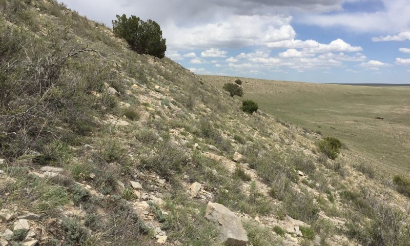
Figure 10. Community 2.1 in San Miguel County, November 2017. The younger trees on the lower escarpment represent the beginnings of encroachment.
This community exists where late-seral grasses have been suppressed by continuous grazing, but tree encroachment is not pronounced on the lower portions of the escarpment. The latter could be so for any of the following reasons: an upslope seed source is lacking, fire has killed encroaching trees, or herbicides have been applied.
In this community, grasses either enjoy marginal dominance, or are codominant to shrubs. Trees may be present on all portions of the escarpment, but their cover on the lower slopes is less than 2 percent. Foliar cover ranges from 30 to 55 percent. Total canopy cover of warm season grasses is between 15 and 40 percent. Cool-season grass cover is generally under 5 percent. Forbs account for up to 10 percent cover. Annual production averages around 550 pounds per acre, but can range between 400 and 750 pounds per acre, depending mostly on annual weather patterns. Cool-season grasses, particularly New Mexico feathergrass, are much more abundant on the limestone-dominated soils on the upper slopes.
Dominant grass species here are sideoats grama, blue grama, hairy grama, little bluestem, and purple threeawn. Big bluestem and yellow Indiangrass are absent. As in most phases of this site, forbs are relatively diverse, but sulfur flower buckwheat is particularly common on this phase. Broom snakeweed, Bigelow sagebrush, skunkbush sumac, and plains yucca are the most common shrub species. Tree species (particularly oneseed juniper) often inhabit shallow limestone soils on the upper escarpment, and younger individuals can often be found encroaching on the deeper soils below, although total tree cover remains below 2 percent.
Reduced total production and root diversity translate to reduced rates of energy flow and soil organic matter accumulation. This, in turn, leads to lower water-holding capacity. Thus, past the State 2 threshold, diminished plant productivity appears to be self-perpetuating. Fortunately, high surface fragment cover translates to lower rates of erosion than would be otherwise expected on such steep and sparsely-vegetated slopes.
Dominant plant species
-
broom snakeweed (Gutierrezia sarothrae), shrub
-
Bigelow sage (Artemisia bigelovii), shrub
-
skunkbush sumac (Rhus trilobata), shrub
-
soapweed yucca (Yucca glauca), shrub
-
sideoats grama (Bouteloua curtipendula), grass
-
blue grama (Bouteloua gracilis), grass
-
hairy grama (Bouteloua hirsuta var. hirsuta), grass
-
little bluestem (Schizachyrium scoparium), grass
-
purple threeawn (Aristida purpurea), grass
-
New Mexico feathergrass (Hesperostipa neomexicana), grass
Community 2.2
Diminished grasses, encroaching trees.
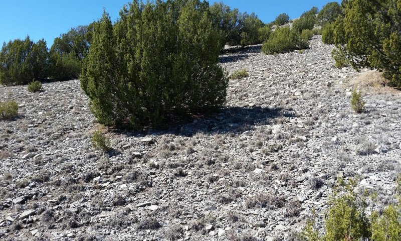
Figure 11. Community 2.2 in Mora County, October 2018. Herbaceous production is quite low here, even for this community phase.
This community exists where grasses have been heavily impacted by continuous grazing and further suppressed by competition with encroaching trees. Shrub cover is often conspicuously low, suggesting that trees are out-competing shrubs for resources. The forb community is quite sparse and, in contrast to other phases, is often limited to a few species. In most cases, tree encroachment appears to be the result of reduced fuel loads rather than active fire suppression.
In this community, grasses are typically dominant in terms of canopy cover, but their vigor is quite low. Tree cover is greater than 2 percent on all slope positions, and is often much higher. Foliar cover ranges from 25 to 60 percent. Total canopy cover of warm season grasses is between 15 and 40 percent. Cool-season grass cover is generally under 2 percent. Forbs typically account less than 2 percent cover. Shrub cover is typically less than 5 percent, suggesting that trees have a competitive advantage over other woody species. Annual production averages around 400 pounds per acre, but can range between 250 and 700 pounds per acre, depending largely on annual weather patterns. Cool-season grasses, particularly New Mexico feathergrass, are much more abundant on the limestone-dominated soils on the upper slopes.
Dominant grass species here are sideoats grama, blue grama, hairy grama, galleta, and purple threeawn. Big bluestem and yellow Indiangrass are absent. Unlike other phases of this site, forbs diversity is generally low, but the dominant forb species vary considerably between locations. Perkysue and low spurge are the most commonly-documented forb species. Broom snakeweed, skunkbush sumac, and plains yucca are the most common shrub species. In contrast to all other phases, Bigelow sagebrush is typically absent on lower slope positions. Trees (particularly oneseed juniper) abound on all slope positions, but older individuals are typically confined to lithic soils near the shoulders of escarpments.
Minimal total production and root diversity translate to reduced rates of energy flow and soil organic matter accumulation. This, in turn, leads to lower water-holding capacity. Thus, past the State 2 threshold, diminished plant productivity appears to be self-perpetuating. Fortunately, high surface fragment cover translates to lower rates of erosion than would be otherwise expected on such steep and sparsely-vegetated slopes.
Pathway P2.1A
Community 2.1 to 2.2
Diminished grasses, abundant shrubs
Diminished grasses, encroaching trees.
This pathway represents a prolonged period without fire. This, coupled with grazing pressure on herbaceous plants, gives a competitive advantage to tree species, particularly oneseed juniper. Increased competition from trees suppresses the growth of all other functional groups. This translates to diminished understory fuel loads and a decreased likelihood of stand-replacing fire.
Pathway P2.2A
Community 2.2 to 2.1
Diminished grasses, encroaching trees.
Diminished grasses, abundant shrubs
This pathway represents tree mortality—resulting from either a stand-replacing fire or from chemical or mechanical treatments. Given that effective fire requires significant understory fuel loads, and the suppression of understory species by trees appears to be self-perpetuating, fire alone may not be a viable management option. Certain producers have resorted to a three-pronged approach: herbicide application and deferred grazing, followed by prescribed fire once adequate fuel loads are attained.
Transition T1A
State 1 to 2
This pathway represents season-long grazing providing little rest and recovery for preferred grazed plants during critical growing periods, coupled with high utilization. The absence of fire is also a component of this pathway. Drought is thought to push the plant community over the threshold into the degraded State 2. During this transition, tallgrass species are extirpated. Highly palatable and grazing-sensitive grass species are diminished—both in vigor and abundance. Concurrently, shrub and tree species enjoy a competitive advantage, and increase in abundance.
Restoration pathway R2A
State 2 to 1
This process results in the recovery of the vigor and diversity of herbaceous species, as well as a significant increase in total productivity. Since tree encroachment beyond the shallowest soils of the upper escarpment seems to effectively prevent such a process, it is likely that this process will only proceed from community phase 2.1. While the eradication of tree species will do much to promote the vigor of other functional groups, the recovery of vigor among existing palatable species will also require careful grazing management. Since State 2 lacks some of the species present in State 1, restoration will be incomplete without the reintroduction of certain species—particularly big bluestem. Whether or not the establishment of these species requires human intervention will depend on a number of factors, including proximity to a seed source and the activities of migratory animals.


