Natural Resources
Conservation Service
Ecological site R071XY042NE
Loess Breaks
Last updated: 1/08/2025
Accessed: 04/10/2026
General information
Provisional. A provisional ecological site description has undergone quality control and quality assurance review. It contains a working state and transition model and enough information to identify the ecological site.
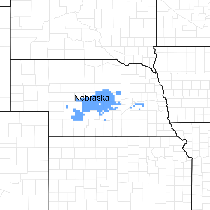
Figure 1. Mapped extent
Areas shown in blue indicate the maximum mapped extent of this ecological site. Other ecological sites likely occur within the highlighted areas. It is also possible for this ecological site to occur outside of highlighted areas if detailed soil survey has not been completed or recently updated.
MLRA notes
Major Land Resource Area (MLRA): 071X–Central Nebraska Loess Hills
MLRA 71 is named “The Central Nebraska Loess Hills” and is located exclusively in Nebraska. The approximately 5.3 million acre landscape covers all or parts of 21 counties, primarily Custer, Dawson, Buffalo, Sherman, Howard, Valley, Greeley, and Hall. The physical appearance of the landscape is dominated by loess hills dissected by the North, Middle, and South Loup Rivers and their tributaries. The Platte River defines the southern border. The elevation in MLRA 71 ranges from over 3,000 to less than 1,700 feet above sea level, with average local relief stretching from 20 to 200 feet. Average annual precipitation ranges from 21 to 26 inches, with the number of freeze-free days averaging around 200.
Loess overlays the surface of almost all of the uplands in this MLRA. Alluvial clay, silt, sand, and gravel are deposited in the stream and river valleys and can be extensive in the major drainages. Terraces are common in the valleys along the river systems. The predominate soil orders are mesic, udic Mollisols and Entisols, commonly represented by the Coly, Uly, Cozad, Hord, Hall, and Holdrege soil series.
The matrix vegetation type is mixed-grass prairie, with big and little bluestem, switchgrass, Indiangrass, and sideoats and blue grama making up the bulk of the warm-season species, while western wheatgrass is the dominant cool-season species. The primary large-patch vegetative component of the landscape is dominated by needle and thread, prairie sandreed, sand and little bluestem, and blue grama. The majority of the small-patch communities are associated with upland playas and the wetter sites found along the floodplains.
Forty four percent of the land in this MLRA has been broken out of native prairie and farmed; mostly corn, alfalfa, and some soybeans, while 48 percent of the grasslands remain intact. Livestock grazing, primarily cattle, is a major industry here. Wildlife flourishes in this combination of crop and grassland environment, with both mule and white-tailed deer being the most abundant wild ungulate. A variety of smaller species, including coyote, raccoon, opossum, porcupines, muskrat, beaver, squirrel, and mink thrive in the region, as well as a suite of grassland and upland birds. The rivers, streams, and lakes harbor excellent fisheries.
This landscape developed under Northern Great Plains climatic conditions, light to severe grazing by bison and other large herbivores, and repeated natural or man-caused wildfire. Other biotic and abiotic factors also typically influence soil and site development. This is a disturbance driven ecosystem, evolving under the influences of herbivory, fire, and variable climate. Historically, these processes created a heterogenous mosaic of plant communities and structure heights across the region. Any given site in this landscape experienced fire every 7 to 9 years. The fires were caused both by lightning strikes, and were set by native Americans, who used fire for warfare, signaling, and to refresh the native grasses. These people understood the value of fire as a tool, and that the highly palatable growth following a fire provided both excellent forage for their horses and attracted grazing game animals such as bison and elk.
Fragmentation of the native grasslands by conversion to cropland, transportation corridors, and other development by European man has effectively disrupted the natural fire regime of this ecosystem. This has allowed encroachment by native and introduced shrubs and trees into the remnants of the native prairie throughout the MLRA. Aggressive fire suppression policies have exacerbated this process to the point that shrub and tree encroachment is a major ecological issue in the majority of both native and re-seeded grasslands.
Even as post European settlement's alteration of the fire regime allows the expansion of the woody component of the native prairie, introduction of eastern redcedar as a windbreak component further facilitates invasion by this species. While eastern redcedar is native to Nebraska, the historic population in MLRA 71 was limited to isolated pockets in rugged river drainages that were subsequently insulated from fire, or non-existent. Widespread plantings of windbreaks with eastern redcedar as a primary component has established a seed source for the aggressive woody plant. The ensuing encroachment into the native grasslands degrades the native wildlife habit and causes significant forage loss for domestic livestock. However, since it is not a root-sprouter, eastern redcedar is very susceptible to fire when under six feet tall. Management with prescribed fire is exceedingly effective if applied before this stage. Larger eastern redcedars can also be controlled with fire but requires the use of specially designed ignition and suppression techniques.
Classification relationships
Major Land Resource Area (MLRA): Major Land Resource Area (MLRA)71 (USDA-Natural Resources Conservation Service, 2006)
Level IV Ecoregions of the Conterminous United States
Ecological site concept
The Loess Breaks ecological site is an upland site located in a run-off position with slopes greater than 30 percent. Slip-slopes and cat-steps are evident.
Associated sites
| R071XY036NE |
Loamy Upland This site is adjacent to and usually below the Loess Breaks. |
|---|---|
| R071XY037NE |
Limy Upland This site is located adjacent to and often below the Loess Breaks site. |
Similar sites
| R071XY037NE |
Limy Upland The Limy Upland ecological site also has an effervescent soil due to its calcareous surface layer but is located on slopes of less than 30 percent. Slip-slopes or catsteps are not present. |
|---|---|
| R071XY036NE |
Loamy Upland The Loamy Upland ecological site is differentiated from the Loess Breaks site by the absence of a calcareous surface layer, slopes of less than 30 percent, and absence of slip-slopes or catsteps. |
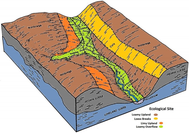
Figure 2.
Table 1. Dominant plant species
| Tree |
Not specified |
|---|---|
| Shrub |
Not specified |
| Herbaceous |
(1) Andropogon gerardii |
Physiographic features
This site occurs on hillslopes and valley sides that have been dissected by geologic erosion. The very steep slopes of this site are characteristically broken with a series of short slope slips, commonly referred to as catsteps. The depth and height of these catsteps intensifies with increasing slope. Vertical faces of loess, areas of broken sod, and deep gullies are common on this site. Vehicular traffic is very limited to impossible on this site. This site produces runoff to areas lower on the landscape.
Table 2. Representative physiographic features
| Landforms |
(1)
Hillslope
|
|---|---|
| Runoff class | High |
| Flooding frequency | None |
| Ponding frequency | None |
| Elevation | 1,630 – 3,075 ft |
| Slope | 30 – 60% |
| Water table depth | 80 in |
| Aspect | Aspect is not a significant factor |
Climatic features
Annual precipitation ranges from 22 to 26 inches per year. Winds are estimated to average about 14 miles per hour annually. Occasional strong storms may bring brief periods of high winds with gusts to more than 60 miles per hour. Growth of native cool-season plants begins in early April and continues to about mid-June. Native warm-season plants begin growth in early June and continue to early August. Green up of cool-season plants may occur in September and October.
Table 3. Representative climatic features
| Frost-free period (characteristic range) | 120-131 days |
|---|---|
| Freeze-free period (characteristic range) | 135-154 days |
| Precipitation total (characteristic range) | 23-26 in |
| Frost-free period (actual range) | 115-140 days |
| Freeze-free period (actual range) | 134-165 days |
| Precipitation total (actual range) | 23-27 in |
| Frost-free period (average) | 127 days |
| Freeze-free period (average) | 147 days |
| Precipitation total (average) | 25 in |
Figure 3. Monthly precipitation range
Figure 4. Monthly minimum temperature range
Figure 5. Monthly maximum temperature range
Figure 6. Monthly average minimum and maximum temperature
Figure 7. Annual precipitation pattern
Figure 8. Annual average temperature pattern
Climate stations used
-
(1) BURWELL [USC00251345], Burwell, NE
-
(2) CANADAY STEAM PLT [USC00251450], Lexington, NE
-
(3) NORTH LOUP [USC00256040], North Loup, NE
-
(4) RAVENNA [USC00257040], Ravenna, NE
-
(5) STAPLETON 5W [USC00258133], Stapleton, NE
-
(6) ANSELMO 2 SE [USC00250245], Anselmo, NE
-
(7) ARNOLD [USC00250355], Arnold, NE
-
(8) LOUP CITY [USC00254985], Loup City, NE
-
(9) MASON CITY [USC00255250], Mason City, NE
-
(10) SAINT PAUL [USC00257515], Saint Paul, NE
-
(11) GRAND ISLAND AP [USW00014935], Grand Island, NE
-
(12) BROKEN BOW 2 W [USC00251200], Broken Bow, NE
-
(13) KEARNEY 4 NE [USC00254335], Kearney, NE
-
(14) OCONTO [USC00256167], Oconto, NE
-
(15) CENTRAL CITY [USC00251560], Central City, NE
-
(16) COMSTOCK [USC00251835], Comstock, NE
-
(17) GOTHENBURG [USC00253365], Gothenburg, NE
-
(18) OVERTON 3 W [USC00256439], Overton, NE
-
(19) TAYLOR [USC00258455], Taylor, NE
Influencing water features
This site is an upland site and functions independently from ground and surface water features.
Soil features
This site is situated on very steep slope faces of loess hills and includes narrow ridges and divides between these slope faces. The slopes of the soils in this site range from 30 percent to near vertical, with slopes dominantly exceedingly 60 percent.
The soils on this site are very deep and have thin, normally calcareous, silty surface layers. Organic matter content is generally low to moderately low in the surface layer. The silty substratum is calcareous with relatively low inherent fertility, and generally has a calcium carbonate equivalent of less than 10 percent. Included within this site are surfaces that have broken sod and are generally unstable. The soils on this site are highly susceptible to both wind and water erosion when void of vegetative protection.
Coly is the only soil series associated with this site. More information can be found in the various soil survey reports. Contact the local USDA Service Center for internet links to soil survey data that includes more details specific to your location.
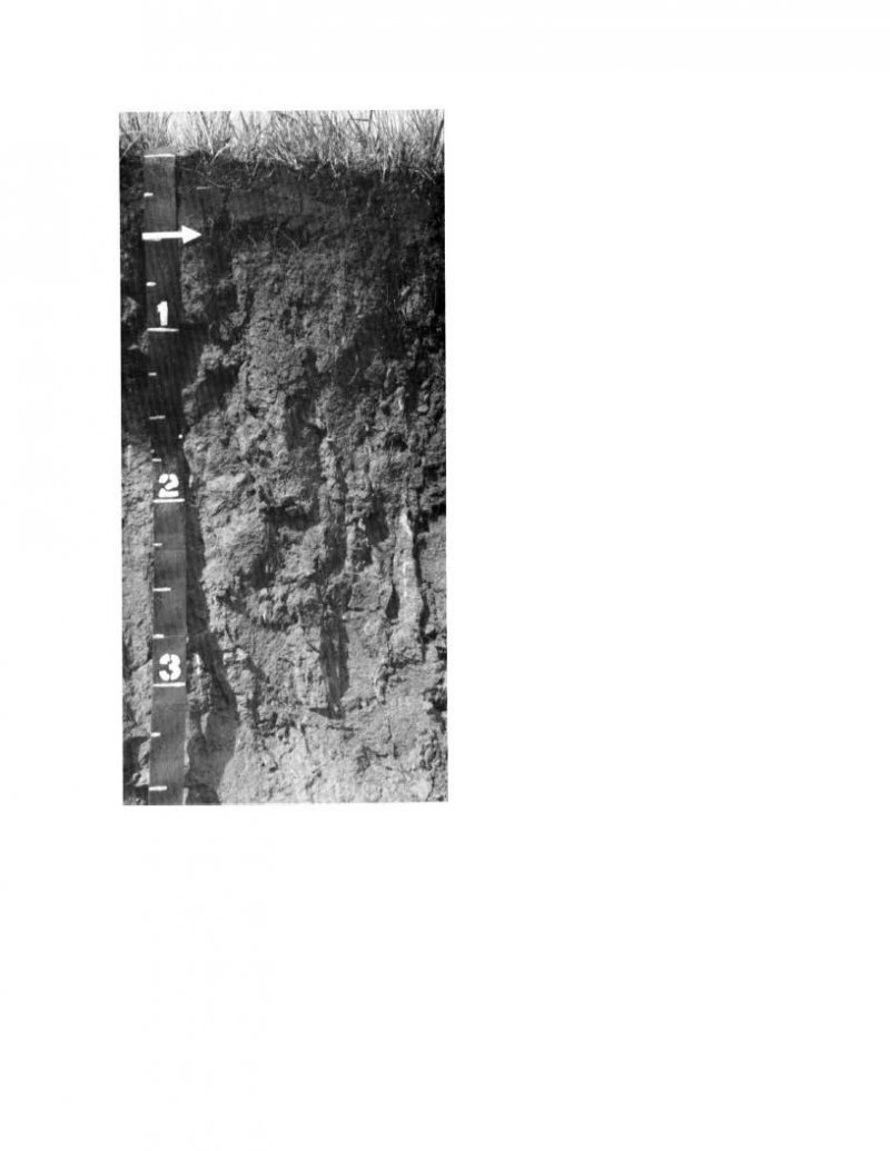
Figure 9. Coly series profile
Table 4. Representative soil features
| Parent material |
(1)
Loess
|
|---|---|
| Surface texture |
(1) Silt loam |
| Family particle size |
(1) Loamy |
| Drainage class | Well drained |
| Permeability class | Moderate |
| Soil depth | 80 in |
| Surface fragment cover <=3" | Not specified |
| Surface fragment cover >3" | Not specified |
| Available water capacity (0-40in) |
6.8 – 8.7 in |
| Calcium carbonate equivalent (0-40in) |
8% |
| Electrical conductivity (0-40in) |
1 mmhos/cm |
| Sodium adsorption ratio (0-40in) |
Not specified |
| Soil reaction (1:1 water) (0-40in) |
6.6 – 8.4 |
| Subsurface fragment volume <=3" (Depth not specified) |
Not specified |
| Subsurface fragment volume >3" (Depth not specified) |
Not specified |
Ecological dynamics
This site occurs on very steep uplands that have been dissected by geologic erosion, and
is generally not a preferred grazing area because of the steepness of the slopes. Adjacent sites are much flatter and generally receive the majority of the grazing pressure. When excessive grazing does occur, erosion is greatly accelerated.
This is a disturbance driven site, with the disturbances being herbivory, fire, and variable climate. Changes occur in the plant communities due to short-term weather variations, impacts of native and exotic plant and animal species, and management actions. Even as post European settlement's alteration of the fire regime allows the expansion of the woody component of the native prairie, introduction of eastern redcedar as a windbreak species has compounded the issue.
While eastern redcedar is native to Nebraska, the historic population in MLRA 71 was limited to isolated pockets in rugged river drainages that were subsequently insulated from fire, or non-existent. Widespread plantings of windbreaks with eastern redcedar as a primary component has provided a seed source for the aggressive woody plant. The ensuing encroachment into the native grasslands degrades the native wildlife habit and causes significant forage loss for domestic livestock. However, since it is not a root sprouter, eastern redcedar is very susceptible to fire when under six feet tall. Management with prescribed fire is exceedingly effective if applied before this stage.
Heavy grazing without adequate rest periods causes big bluestem and other tallgrass species to rapidly lose productive capacity through loss of vigor and reproductive potential. Sideoats grama will initially increase to fill the voids left by declining tallgrass species. Continued overgrazing results in a decrease of sideoats grama, and blue grama, Kentucky bluegrass, and the less palatable forbs increase as the warm-season tallgrass species decline. Smooth brome readily encroaches on this site, and erosion in the form of gullying and terraces on the steeper areas occur with continued heavy grazing without adequate recovery periods.
Grazing management that includes proper stocking rates with adequate recovery periods for the entire grazing unit is usually required to improve or maintain this site. Intensive grazing management using concentrated livestock numbers, combined with long recovery periods can be beneficial in improving forage utilization, quantity, and quality.
The reference plant community has been determined by study of rangeland relic areas, areas protected from excessive disturbance, seasonal use pastures, appropriately timed and controlled grazing, and historical accounts.
The State and Transition Model (STM) is depicted below, and includes a Reference State, a Native Shortgrass/Invaded Grass State, Degraded State, and an Invaded Woody State. Each state represents the crossing of a major ecological threshold due to the alteration of the functional dynamic properties of the ecosystem. The primary properties observed to determine this change are soil stability, vegetative communities, and the hydrologic cycle. Each state may have one or more plant communities that fluctuate in species composition and abundance within the normal parameters of the state. Within each state, communities may degrade or recover in response to natural and man caused disturbances such as variation in the degree and timing of herbivory, presence or absence of fire, and climatic and local fluctuations in the precipitation regime. The processes that cause the movement between the states and communities are discussed in more detail in the state and community descriptions following the diagram.
State and transition model
More interactive model formats are also available.
View Interactive Models
Click on state and transition labels to scroll to the respective text
State 1 submodel, plant communities
State 2 submodel, plant communities
State 3 submodel, plant communities
State 4 submodel, plant communities
State 1
Reference State
The Reference State describes the range of vegetative communities that occur on Loess Breaks site where the natural processes are mostly intact. Historically, the amount of grazing varied with the slopes. Areas with slopes steeper than 45 percent were rarely grazed. The historical vegetation of this site is mixed-grass prairie. The Reference Community is representative of the native plant community historically maintained by frequent fire and herbivory (grazing) with adequate recovery periods. The Degraded Native Grass, At-Risk Native Grass, and Excessive Litter Communities result from management decisions that are unfavorable for the plant community and soil health. High perennial grass cover and production facilitate increased soil moisture retention, high infiltration rates, plant vigor, and overall soil quality.
Dominant plant species
-
big bluestem (Andropogon gerardii), grass
-
little bluestem (Schizachyrium scoparium), grass
-
sideoats grama (Bouteloua curtipendula), grass
-
blue grama (Bouteloua gracilis), grass
-
hairy grama (Bouteloua hirsuta), grass
Community 1.1
Reference Community
The Reference Community serves as a description of the native plant community that naturally occurs on the site when the natural disturbance regimes are intact, or closely mimicked by management practices. The plant composition of this community is 75 to 85 percent grasses and grass-like plants, 5 to 10 percent forbs, and 2 to 5 percent shrubs. Little bluestem, big bluestem, and sideoats grama, are the dominant species, and secondary species include plains muhly, blue grama, and hairy grama. Forbs are diverse and include Nuttall’s sensitive-briar, dotted gayfeather, and scurfpeas. Shrubs include leadplant, rose, and western snowberry. This plant community is diverse and productive. With proper management and adequate recovery periods between grazing events, this site can withstand short-term environmental stress, short-term heavy use or several years of non-use. Total annual production ranges from 1,800 to 2,800 pounds per acre of air dry vegetation with a representative value of 2,125 pounds per acre.
Dominant plant species
-
leadplant (Amorpha canescens), shrub
-
western snowberry (Symphoricarpos occidentalis), shrub
-
big bluestem (Andropogon gerardii), grass
-
sideoats grama (Bouteloua curtipendula), grass
-
little bluestem (Schizachyrium scoparium), grass
-
Nuttall's sensitive-briar (Mimosa nuttallii), other herbaceous
-
dotted blazing star (Liatris punctata), other herbaceous
-
purple prairie clover (Dalea purpurea var. purpurea), other herbaceous
-
silverleaf Indian breadroot (Pediomelum argophyllum), other herbaceous
-
white heath aster (Symphyotrichum ericoides var. ericoides), other herbaceous
Figure 10. Annual production by plant type (representative values) or group (midpoint values)
Table 5. Annual production by plant type
| Plant type | Low (lb/acre) |
Representative value (lb/acre) |
High (lb/acre) |
|---|---|---|---|
| Grass/Grasslike | 1655 | 1890 | 2475 |
| Forb | 105 | 160 | 215 |
| Shrub/Vine | 40 | 75 | 110 |
| Total | 1800 | 2125 | 2800 |
Figure 11. Plant community growth curve (percent production by month). NE7138, Central NE Loess Hills, warm-season dominant. Warm-season grass dominant.
| Jan | Feb | Mar | Apr | May | Jun | Jul | Aug | Sep | Oct | Nov | Dec |
|---|---|---|---|---|---|---|---|---|---|---|---|
| J | F | M | A | M | J | J | A | S | O | N | D |
| 0 | 0 | 3 | 7 | 15 | 20 | 30 | 15 | 5 | 5 | 0 | 0 |
Community 1.2
Degraded Native Grass Community
The Degraded Native Grass Community develops under grazing without adequate recovery periods between grazing events. Annual production and grass diversity are reduced. Little bluestem begins to dominate the site as big bluestem, Indiangrass, and the other more palatable tallgrass species decrease. The less palatable forbs including Cuman ragweed, upright prairie coneflower, and slimflower scurfpea may increase as well. Timing of defoliation events determines the proportions of cool-season to warm-season grasses within the community. Overall community diversity is reduced with increased grazing pressure. Due to the decrease in plant litter, effective precipitation is reduced. This causes a significant decline in production compared to the reference plant community. Soil health is beginning to be affected by the impacts on the nutrient, mineral, and hydrologic cycles. Total annual production ranges from 1,250 to 2,250 pounds per acre of air dry vegetation and averages 1,750 pounds per acre.
Dominant plant species
-
little bluestem (Schizachyrium scoparium), grass
-
sideoats grama (Bouteloua curtipendula), grass
-
Cuman ragweed (Ambrosia psilostachya), other herbaceous
-
slimflower scurfpea (Psoralidium tenuiflorum), other herbaceous
-
upright prairie coneflower (Ratibida columnifera), other herbaceous
Figure 12. Plant community growth curve (percent production by month). NE7138, Central NE Loess Hills, warm-season dominant. Warm-season grass dominant.
| Jan | Feb | Mar | Apr | May | Jun | Jul | Aug | Sep | Oct | Nov | Dec |
|---|---|---|---|---|---|---|---|---|---|---|---|
| J | F | M | A | M | J | J | A | S | O | N | D |
| 0 | 0 | 3 | 7 | 15 | 20 | 30 | 15 | 5 | 5 | 0 | 0 |
Community 1.3
At-Risk Native Grass Community
The At-Risk Native Grass Community marks a shift in plant composition from that of tall and mid-grass community to a mid- and shortgrass community. Annual production is reduced and diversity of grasses decreases. Tallgrass species are reduced to remnants and little bluestem and sideoats grama have decreased significantly. Blue grama, hairy grama, and composite dropseed are increasing. Grazing evasive cool-season species and shrubs such as soapweed yucca, western snowberry, and smooth sumac are increasing. As plant litter decreases, effective precipitation is reduced. This results in a significant decline in production compared to the Degraded Native Grass Community. Soil health is affected by impacts on the nutrient, mineral, and hydrology cycles. The amount of bare ground has increased, resulting in increasing erosion. Total annual production ranges from 850 to 1,750 pounds per acre of air dry vegetation and averages 1,300 pounds.
Dominant plant species
-
smooth sumac (Rhus glabra), shrub
-
western snowberry (Symphoricarpos occidentalis), shrub
-
soapweed yucca (Yucca glauca), shrub
-
blue grama (Bouteloua gracilis), grass
-
hairy grama (Bouteloua hirsuta), grass
-
little bluestem (Schizachyrium scoparium), grass
-
composite dropseed (Sporobolus compositus), grass
Figure 13. Plant community growth curve (percent production by month). NE7138, Central NE Loess Hills, warm-season dominant. Warm-season grass dominant.
| Jan | Feb | Mar | Apr | May | Jun | Jul | Aug | Sep | Oct | Nov | Dec |
|---|---|---|---|---|---|---|---|---|---|---|---|
| J | F | M | A | M | J | J | A | S | O | N | D |
| 0 | 0 | 3 | 7 | 15 | 20 | 30 | 15 | 5 | 5 | 0 | 0 |
Community 1.4
Excessive Litter Community
The Excessive Litter Community occurs when grazing is removed for long periods of time in the absence of fire. Plant composition is similar to the reference plant community, however individual species production and frequency will be lower. Over time, species diversity decreases. Much of the nutrients on the site are tied up in excessive litter. Nutrient recycling is severely reduced by the lack of animal impact. Decomposition is slowed due to the semiarid environment. The litter limits sunlight from reaching root crowns, and many plants, particularly bunchgrasses, die. The reproductive potential of perennial plants is reduced. Bare ground is common in advanced stages. Annual forbs, grasses, and cryptogamic crusts often occupy these areas. If periodic grazing and fire are limited, perennial plants die and erosion may increase on steeper slopes. Increased resource inputs and management will be required to establish a more productive perennial plant community.
Dominant plant species
-
little bluestem (Schizachyrium scoparium), grass
-
sideoats grama (Bouteloua curtipendula), grass
-
big bluestem (Andropogon gerardii), grass
Figure 14. Plant community growth curve (percent production by month). NE7138, Central NE Loess Hills, warm-season dominant. Warm-season grass dominant.
| Jan | Feb | Mar | Apr | May | Jun | Jul | Aug | Sep | Oct | Nov | Dec |
|---|---|---|---|---|---|---|---|---|---|---|---|
| J | F | M | A | M | J | J | A | S | O | N | D |
| 0 | 0 | 3 | 7 | 15 | 20 | 30 | 15 | 5 | 5 | 0 | 0 |
Pathway 1.1A
Community 1.1 to 1.2
Continuous season-long grazing without adequate recovery periods during the growing season will shift the Reference Community to the Degraded Native Grass Community. Continued defoliation without adequate rest periods will significantly reduce the proportions of the tallgrass species and begin to reduce the proportions of midgrass species. The more accessible slopes of this site are preferred by livestock and can lead to uneven grazing distribution.
Pathway 1.1B
Community 1.1 to 1.4
Interruption of the natural disturbances of herbivory and fire will result in conversion of the Reference Community to the Excessive Litter Community.
Pathway 1.2A
Community 1.2 to 1.1
Prescribed grazing with adequate recovery periods will shift the Degraded Native Grass Community toward the Reference Community.
Pathway 1.2B
Community 1.2 to 1.3
Continuous season-long grazing without adequate recovery periods during the growing season will shift the Degraded Native Grass Community to an At-Risk Native Grass Community. Continued defoliation without adequate rest periods will significantly reduce the proportions of the tallgrass species and begin to reduce the proportions of midgrass species. The more accessible slopes of this site are preferred by livestock and can lead to uneven grazing distribution.
Pathway 1.2C
Community 1.2 to 1.4
Interruption of the natural disturbances of herbivory and fire will result in conversion of the Degraded Native Grass Community to the Excessive Litter Community.
Pathway 1.3A
Community 1.3 to 1.2
Prescribed grazing with adequate recovery periods will shift the At-Risk Native Grass Community toward the Degraded Native Grass Community.
Pathway 1.4A
Community 1.4 to 1.1
Prescribed grazing with adequate recovery periods and/or prescribed burning will shift the Excessive Litter Community toward the Reference Community.
Pathway 1.4B
Community 1.4 to 1.2
Prescribed grazing with adequate recovery periods and/or prescribed burning will shift this Excessive Litter Community toward the Degraded Native Grass Community.
State 2
Native Shortgrass/Invaded Grass State
The Native Shortgrass/Invaded Grass State has deteriorated in quality from the Reference State. Few native, warm-season, tall- and midgrasses remain. Native shortgrasses and invasive species dominate the site.
Dominant plant species
-
Kentucky bluegrass (Poa pratensis), grass
-
blue grama (Bouteloua gracilis), grass
Community 2.1
Native Shortgrass/Invaded Grass Community
This plant community develops as continuous season-long heavy grazing continues. Annual production and diversity of grasses is dramatically reduced from the Reference State. Blue grama and Kentucky bluegrass dominate the site. Annual grasses and annual forbs are common. Only remnants of tall- and midgrasses remain. This plant community is at risk of losing all tall- and midgrass species and crossing a threshold to the Degraded State. Once this occurs, soil stability and hydrologic function degrade to the extent that restoration may not be possible. Community diversity is low due to continued grazing pressure. Areas of bare ground continue to expand, resulting in severe soil erosion. Total annual production ranges from 750 to 1,250 pounds per acre of air dry vegetation with a representative value of 1,000 pounds.
Dominant plant species
-
blue grama (Bouteloua gracilis), grass
-
Kentucky bluegrass (Poa pratensis), grass
Figure 15. Plant community growth curve (percent production by month). NE7136, Central NE Loess Hills, cool season/warm season co-dominant. Cool-season grass and warm-season grass co-dominant.
| Jan | Feb | Mar | Apr | May | Jun | Jul | Aug | Sep | Oct | Nov | Dec |
|---|---|---|---|---|---|---|---|---|---|---|---|
| J | F | M | A | M | J | J | A | S | O | N | D |
| 0 | 0 | 5 | 10 | 20 | 25 | 20 | 10 | 5 | 5 | 0 | 0 |
State 3
Degraded State
The Degraded State is a result of overgrazing and misuse. Weedy annuals have replaced the desirable species. Ground cover is reduced and the system becomes more vulnerable to soil erosion.
Dominant plant species
-
field brome (Bromus arvensis), grass
-
Fendler threeawn (Aristida purpurea var. longiseta), grass
Community 3.1
Annual Plant Community
With continued season-long heavy grazing, perennial grass cover has decreased and this site becomes susceptible to erosion. Annual grasses and forbs dominate the plant community. Loss of desirable species results in an increase in bare ground, and plant diversity is low. Plant vigor and production are significantly reduced. Total annual production during an average year varies dramatically.
Dominant plant species
-
twistspine pricklypear (Opuntia macrorhiza), shrub
-
soapweed yucca (Yucca glauca), shrub
-
field brome (Bromus arvensis), grass
-
Fendler threeawn (Aristida purpurea var. longiseta), grass
State 4
Invaded Woody State
This Invaded Woody State represents a state that has excessive woody species encroachment. The woody species are present due to lack of prescribed fire and brush management. The sites typically have a loss of native warm-season grasses, reduced forage production, and reduced soil quality.
Dominant plant species
-
eastern redcedar (Juniperus virginiana), tree
-
twistspine pricklypear (Opuntia macrorhiza), shrub
-
Kentucky bluegrass (Poa pratensis), grass
Community 4.1
Eastern Redcedar Community
The Eastern Redcedar Community can develop when fire is withheld from this site over an extended period of time. Generally, this site is very conducive to eastern redcedar invasion. Eastern redcedars will eventually dominate the site, reducing grass production and limiting grazing potential. Honeylocust encroachment may occur in the eastern portions of the MLRA. Eastern redcedar control can usually be accomplished with a controlled burn while the trees are six foot tall or less.
Dominant plant species
-
eastern redcedar (Juniperus virginiana), tree
-
honeylocust (Gleditsia triacanthos), tree
-
twistspine pricklypear (Opuntia macrorhiza), shrub
-
soapweed yucca (Yucca glauca), shrub
-
Kentucky bluegrass (Poa pratensis), grass
Transition T1A
State 1 to 2
Continuous season-long grazing without adequate recovery periods during the growing season will cause the Reference Community to lose all tall- and midgrass species and cross an ecological threshold to the Native Shortgrass/Invaded Grass State. Once this occurs it will require considerable time and expense to return this site to a higher condition. Water infiltration is reduced due to the root mass present of the blue grama and Kentucky bluegrass sod.
Transition T1B
State 1 to 4
Disruption of the natural fire regime and lack of brush management cause a major shift in the vegetative community. This causes the system to cross the threshold into the Invaded Woody State.
Restoration pathway R2A
State 2 to 1
Long-term prescribed grazing will shift the Native Shortgrass/Invaded Grass State to the Reference State. A shift to this state may take decades to achieve.
Transition T2A
State 2 to 3
Continuous season-long grazing without adequate recovery periods during the growing season will shift the Native Shortgrass/Invaded Grass State to the Degraded State. The Degraded State has a significant risk of soil erosion. The percent and aspect of slope will impact the rate of change.
Transition T2B
State 2 to 4
Disruption of the natural fire regime causes a major shift in the vegetative community. The resulting impacts cause the system to cross the threshold from the Reference State into the Invaded Woody State.
Transition T3A
State 3 to 4
Lack of fire and/or brush management will cause the Degraded State to cross a threshold and transition to the Invaded Woody State.
Restoration pathway R4A
State 4 to 1
Brush management, prescribed grazing, harvesting, prescribed burning, or wildfire will eventually cause the Invaded Woody State to shift back to the Reference State.
Restoration pathway R4B
State 4 to 2
Brush management, prescribed grazing, harvesting, prescribed burning, or wildfire will eventually cause the Invaded Woody State to shift back to the Native/ Invaded Grass State.
Restoration pathway R4C
State 4 to 3
Brush management, prescribed grazing, harvesting, prescribed burning, or wildfire will eventually cause the Invaded Woody State to shift back to the Degraded State.
Additional community tables
Table 6. Community 1.1 plant community composition
| Group | Common name | Symbol | Scientific name | Annual production (lb/acre) | Foliar cover (%) | |
|---|---|---|---|---|---|---|
|
Grass/Grasslike
|
||||||
| 1 | Warm-Season Midgrass | 531–1063 | ||||
| little bluestem | SCSC | Schizachyrium scoparium | 425–744 | 20–35 | ||
| sideoats grama | BOCU | Bouteloua curtipendula | 213–425 | 10–20 | ||
| composite dropseed | SPCOC2 | Sporobolus compositus var. compositus | 0–106 | 0–5 | ||
| 2 | Warm-Season Tallgrass | 319–531 | ||||
| big bluestem | ANGE | Andropogon gerardii | 319–425 | 15–20 | ||
| switchgrass | PAVI2 | Panicum virgatum | 0–106 | 0–5 | ||
| Indiangrass | SONU2 | Sorghastrum nutans | 0–64 | 0–3 | ||
| prairie sandreed | CALO | Calamovilfa longifolia | 0–64 | 0–3 | ||
| 3 | Native, Cool-Season Grass | 0–106 | ||||
| Scribner's rosette grass | DIOLS | Dichanthelium oligosanthes var. scribnerianum | 0–43 | 0–2 | ||
| Canada wildrye | ELCA4 | Elymus canadensis | 0–43 | 0–2 | ||
| needle and thread | HECOC8 | Hesperostipa comata ssp. comata | 0–43 | 0–2 | ||
| porcupinegrass | HESP11 | Hesperostipa spartea | 0–43 | 0–2 | ||
| prairie Junegrass | KOMA | Koeleria macrantha | 0–43 | 0–2 | ||
| western wheatgrass | PASM | Pascopyrum smithii | 0–43 | 0–2 | ||
| 4 | Warm-Season Shortgrass | 0–106 | ||||
| blue grama | BOGR2 | Bouteloua gracilis | 0–106 | 0–5 | ||
| hairy grama | BOHI2 | Bouteloua hirsuta | 0–43 | 0–2 | ||
| plains muhly | MUCU3 | Muhlenbergia cuspidata | 0–43 | 0–2 | ||
| 5 | Grass-likes | 0–64 | ||||
| threadleaf sedge | CAFI | Carex filifolia | 0–64 | 0–3 | ||
| sedge | CAREX | Carex | 0–43 | 0–2 | ||
|
Forb
|
||||||
| 6 | Forbs | 106–213 | ||||
| Forb, perennial | 2FP | Forb, perennial | 21–43 | 1–2 | ||
| Cuman ragweed | AMPS | Ambrosia psilostachya | 21–43 | 1–2 | ||
| purple prairie clover | DAPUP | Dalea purpurea var. purpurea | 21–43 | 1–2 | ||
| dotted blazing star | LIPU | Liatris punctata | 21–43 | 1–2 | ||
| silverleaf Indian breadroot | PEAR6 | Pediomelum argophyllum | 21–43 | 1–2 | ||
| upright prairie coneflower | RACO3 | Ratibida columnifera | 21–43 | 1–2 | ||
| white heath aster | SYER | Symphyotrichum ericoides | 21–43 | 1–2 | ||
| yellow sundrops | CASE12 | Calylophus serrulatus | 0–43 | 0–2 | ||
| scarlet beeblossom | GACO5 | Gaura coccinea | 0–43 | 0–2 | ||
| hairy false goldenaster | HEVI4 | Heterotheca villosa | 0–43 | 0–2 | ||
| Nuttall's sensitive-briar | MINU6 | Mimosa nuttallii | 0–43 | 0–2 | ||
| white penstemon | PEAL2 | Penstemon albidus | 0–43 | 0–2 | ||
| slimflower scurfpea | PSTE5 | Psoralidium tenuiflorum | 0–43 | 0–2 | ||
| prairie spiderwort | TROC | Tradescantia occidentalis | 0–43 | 0–2 | ||
| Missouri goldenrod | SOMI2 | Solidago missouriensis | 0–21 | 0–1 | ||
| prairie groundsel | PAPL12 | Packera plattensis | 0–21 | 0–1 | ||
| white sagebrush | ARLU | Artemisia ludoviciana | 0–21 | 0–1 | ||
|
Shrub/Vine
|
||||||
| 7 | Shrubs | 43–106 | ||||
| Shrub (>.5m) | 2SHRUB | Shrub (>.5m) | 21–64 | 1–3 | ||
| leadplant | AMCA6 | Amorpha canescens | 21–64 | 1–3 | ||
| prairie rose | ROAR3 | Rosa arkansana | 21–43 | 1–2 | ||
| western snowberry | SYOC | Symphoricarpos occidentalis | 21–43 | 1–2 | ||
| twistspine pricklypear | OPMA2 | Opuntia macrorhiza | 0–21 | 0–1 | ||
Interpretations
Animal community
Grazing by domestic livestock is one of the major income-producing industries in the area. Rangeland in this area may provide year-long forage for cattle, sheep, or horses. During the dormant period, the forage for livestock use needs to be supplemented with protein because the quality does not meet minimum livestock requirements.
The following table lists suggested stocking rates for cattle under continuous growing season-long grazing under normal growing conditions. These conservative estimates should be used only as guidelines in the initial stages of the conservation planning process. Often, the current plant composition does not entirely match any particular plant community or vegetative state as described in this ecological site description. Because of this, a field visit is recommended to document plant composition and production. More precise carrying capacity estimates should eventually be calculated using this information along with animal preference data, particularly when grazers other than cattle are involved. Under more intensive grazing management, improved harvest efficiencies can result in an increased carrying capacity.
Plant Community - Total Production - Carrying Capacity*
Community 1.1, Reference Community: 2,125 lb./acre and 0.58 AUM/acre**
Community 1.2, Degraded Native Grass Community: 1,750 lb./acre and 0.48 AUM/acre
Community 1.3, At-Risk Community: 1,300 lb./acre and 0.36 AUM/acre
Community 2.1, Native Shortgrass / Invaded Grass Community - 1,000 lb./acre and 0.27 AUM/acre
* Continuous season-long grazing by cattle under average growing conditions (utilizing 50 percent of usable production or 25 percent harvest efficiency).
**AUM = The amount of forage required by one animal unit (one mature cow weighing 1000 pounds and her calf, or their equivalent) for one month or 912 pounds air dry forage.
Wildlife:
Major Land Resource Area (MLRA) 71 lies primarily within the Mixed-Grass Prairie ecosystem. Though European settlers have converted about half of this landscape to farmland, a significant portion of the prairie is still intact. This area still consists of diverse grassland habitats interspersed with varying densities of depressional wetlands and limited woody riparian corridors. These habitats historically provided critical life cycle components for the grassland birds, prairie dogs, and herds of roaming bison, elk, and pronghorn. Bobcats, wolves, and mountain lions occupied the apex predator niche. Diverse populations of small mammals and insects still provide a bountiful prey base for raptors and omnivores such as coyotes, foxes, raccoons, and opossums. In addition, a wide variety of reptiles and amphibians thrive in this landscape.
The Mixed-Grass Prairie was a disturbance-driven ecosystem with fire, herbivory, and climate functioning as the primary disturbances. Following European settlement, elimination of fire, overgrazing, and some habitat fragmentation significantly altered the appearance and functionality of the entire ecosystem. Bison and prairie dogs were historically keystone species, but free-roaming bison herds have been extirpated in this region. The loss of bison and fire as ecological drivers greatly influenced the character of the remaining native grasslands and the habitats that they provide. Fragmentation has reduced habitat quality for numerous area-sensitive species, as highlighted by the decline of the greater prairie chicken.
Historically, an ecological mosaic of the sites provided habitat for species requiring unfragmented grasslands. Most of these important habitat features and components are intact, providing upland nesting habitat for grassland birds and game birds; nesting and escape cover for waterfowl; forbs and insects for brood-rearing habitat; and a forage source for small and large herbivores.
Disruption of the natural fire regime and lack of appropriate grazing management are the greatest threats to the ecosystem dynamics today. Tree and shrub encroachment from lack of fire creates habitat that favors generalist species such as American robin and mourning dove, and provides perches for raptors, increasing the predation mortality on native bird populations. Introduced species such as smooth bromegrass, Kentucky bluegrass, nodding plumeless thistle (musk thistle), and Canada thistle further degrade the biological integrity of many areas of the prairie.
Hydrological functions
Water is the principal factor limiting forage production on this site, which is dominated by soils in hydrologic group B. Permeability is moderate, and runoff potential is medium to high. In general, the infiltration rate is directly proportional to vegetative cover, while the runoff potential is inversely proportional. An exception is sod-bound short grasses. The T erosion factor is 5.
(Refer to NRCS Section 4, National Engineering Handbook (NEH-4) for runoff quantities and hydrologic curves).
Recreational uses
The sloping portions of this site provide a colorful and rustic landscape desired by many people. The less sloping portions are often used for cropland.
Wood products
No appreciable wood products are present on the site.
Other products
None noted.
Supporting information
Inventory data references
Information presented here has been derived from NRCS clipping data and other inventory data. Field observations from range-trained personnel were also used. Those involved in developing this site include Dana Larsen, State Rangeland Management Specialist, NRCS; Chuck Markley, Resource Soil Scientist, NRCS., Neil Dominy, Resource Soil Scientist, NRCS.
Field Offices:
Albion, Broken Bow, Burwell, Central City, Fullerton, Grand Island, Greeley, Kearney, Lexington, Loup City, North Platte, Ord, St. Paul, Thedford.
Other references
High Plains Regional Climate Center, University of Nebraska. (http://hpcc.unl.edu, accessed 12/05/16)
Johnsgaard, P.A. 2001. “The Nature of Nebraska.” University of Nebraska Press.
LaGrange, T.G. 2015. Final Report submitted to EPA for the project entitled: Nebraska’s Wetland Condition Assessment: An Intensification Study in Support of the 2011 National Survey (CD# 97714601), and the related project entitled: Nebraska's Supplemental Clean Water Act §106 Funds, as Related to Participation in National Wetland Condition Assessment (I – 97726201). Nebraska Game and Parks Commission, Lincoln.
Muhs, Daniel R., E. Bettis III, J. Aleinikoff, J. McGeehin, J. Beann, G. Skipp, B. Marshall, H. Roberts, W. Johnson, and R. Benton.
"Origin and paleoclimatic significance of late Quaternary loess in Nebraska: Evidence from stratigraphy, chronology, sedimentology, and geochemistry" (2008). USGS Staff -- Published Research. Paper 162. http://digitalcommons.unl.edu/usgsstaffpub/162 Accessed 12/05/16.
U.S. Dept. of Agriculture. NRCS National Ecological Site Handbook. January, 2014.
U.S. Dept. of Agriculture. NRCS National Engineering Handbook, Section 4. August, 2011.
Personal communications with professional ecologists and wildlife experts.
Rolfsmeier, S.B. and G. Steinauer. 2010. "Terrestrial Ecological Systems and Natural Communities of Nebraska", (version IV)
Nebraska Natural Heritage Program.
USDA, NRCS. National Water and Climate Center, Portland, OR. http://wcc.nrcs.usda.gov Accessed 12/05/16.
USDA, NRCS.1997. National Range and Pasture Handbook.
USDA, NRCS. National Soil Information System, Information Technology Center, Fort Collins, CO. http://nasis.nrcs.usda.gov Accessed 12/05/16.
USDA, NRCS. 2002. The PLANTS Database, Version 3.5 http://plants.usda.gov Accessed 12/05/16. National Plant Data Center, Baton Rouge, LA.
USDA, NRCS, various published soil surveys.
Contributors
Dana Larsen
Doug Whisenhunt
Nadine Bishop
Approval
Suzanne Mayne-Kinney, 1/08/2025
Acknowledgments
Many thanks to the ESD team members who assisted with completion of this document.
Rangeland health reference sheet
Interpreting Indicators of Rangeland Health is a qualitative assessment protocol used to determine ecosystem condition based on benchmark characteristics described in the Reference Sheet. A suite of 17 (or more) indicators are typically considered in an assessment. The ecological site(s) representative of an assessment location must be known prior to applying the protocol and must be verified based on soils and climate. Current plant community cannot be used to identify the ecological site.
| Author(s)/participant(s) | Jeff Nichols, Nadine Bishop |
|---|---|
| Contact for lead author | jeffrey.nichols@usda.gov |
| Date | 11/30/2024 |
| Approved by | Suzanne Mayne-Kinney |
| Approval date | |
| Composition (Indicators 10 and 12) based on | Annual Production |
Indicators
-
Number and extent of rills:
Typically, none. A slight presence of rills may be present on steeper slopes (greater than 35 percent slopes). -
Presence of water flow patterns:
Typically, none. Where water flow patterns do occur, they are rare (less than 2 per square foot or 9.3 square meters), narrow (less than 6 inches or 15 cm), and short (less than 1 foot or 0.3 m) and disconnected and disrupted by perennial vegetation. -
Number and height of erosional pedestals or terracettes:
Typically, none. Occasionally, bunch grasses may be pedestalled (average of 2 or less per square meter) on steeper slopes (greater than 35 percent slopes) with no exposed roots. Drought, wildfire, and prescribed burns should not increase the incidence of pedestals except on the steepest slopes. -
Bare ground from Ecological Site Description or other studies (rock, litter, lichen, moss, plant canopy are not bare ground):
Bare ground is typically 10 percent or less with bare ground patches less than 6 to 8 inches (15 to 20.5 cm) in diameter. Multi-year drought can cause bare ground to increase to 15 percent with bare ground patches of 8 to 12 inches (20.5 to 31 cm) in diameter. Cross sectional viewing of this site give the appearance of more bare ground than vertical viewing due to exposed loess-steps. Bare ground is exposed mineral soil that is not covered by vegetation (basal and/or foliar canopy), litter, standing dead vegetation, gravel/rock, and visible biological crust (e.g., lichen, mosses, algae). -
Number of gullies and erosion associated with gullies:
There are few if any gullies. When gullies are present there is no active head cutting and sides are vegetated. -
Extent of wind scoured, blowouts and/or depositional areas:
Slight wind scouring is possible on areas of exposed loess. -
Amount of litter movement (describe size and distance expected to travel):
Fine litter may move short distances (less than 6 inches or 15 cm) following a significant run-off event; as interspaces are small, there is no difference between litter movement in interspaces and under canopy. Coarse litter generally does not move. -
Soil surface (top few mm) resistance to erosion (stability values are averages - most sites will show a range of values):
Soil stability ratings will range from 3 to 5 in the interspaces and under canopy. -
Soil surface structure and SOM content (include type of structure and A-horizon color and thickness):
The A-horizon is 4 inches (10 cm) thick and soil color is dark grayish brown when moist (10 YR 4/2). The soil structure is weak platy to a depth of 2 inches (5 cm) and weak fine granular below. Soils are predominantly silt loam and soils exhibit a strong effervescence. -
Effect of community phase composition (relative proportion of different functional groups) and spatial distribution on infiltration and runoff:
Plant community composition of 75 to 85 percent perennial grasses and grass-likes, 5 to 10 percent forbs, and 2 to 5 percent shrubs will optimize infiltration on the site. The grass and grass-like component is made up of native, perennial, warm-season, mid-grasses (30-40%), native, perennial, warm-season, tall, rhizomatous grasses (10-20%), native, perennial, cool-season grasses (0-5%), native, perennial, warm-season, short grasses (0-5%), and grass-likes (0-3%). However, exposed loess has more of an effect on infiltration and runoff than the composition of the plant community on steeper slopes.
Infiltration can be adversely impacted by the invasion of Kentucky bluegrass, smooth brome, tall fescue, and trees when present above 10 percent (subdominant designation). Extended drought reduces short and mid-bunchgrasses causing decreased infiltration and increased runoff following intense storms. -
Presence and thickness of compaction layer (usually none; describe soil profile features which may be mistaken for compaction on this site):
None. No compaction layers occur naturally on this site. -
Functional/Structural Groups (list in order of descending dominance by above-ground annual-production or live foliar cover using symbols: >>, >, = to indicate much greater than, greater than, and equal to):
Dominant:
Phase 1.1
1. Native, perennial, warm-season midgrass, 531-1063 #/ac, 25-50% (2 species minimum): little bluestem, sideoats grama, composite dropseed.
Phase 1.2
1. Native, perennial, warm-season midgrass (2 species minimum): little bluestem, sideoats grama, composite dropseed.
Phase 1.3
1. Native, perennial, warm-season midgrass (2 species minimum): little bluestem, sideoats grama, composite dropseed.Sub-dominant:
Phase 1.1
1. Native, perennial, warm-season tallgrass, 319-531 #/ac, 15-25% (1 species minimum): big bluestem, Indiangrass, switchgrass, prairie sandreed.
Phase 1.2
1. Native, perennial, cool-season grass (2 species minimum): Scribner’s rosette grass, Canada wildrye, needle and thread, porcupinegrass, prairie Junegrass, western wheatgrass.
2. Native, perennial, warm-season tallgrass (1 species minimum): big bluestem, Indiangrass, switchgrass, prairie sandreed.
Phase 1.3
1. Native, perennial, warm-season shortgrass (2 species minimum): blue grama, hairy grama, plains muhly.
2. Grass-likes (1 species minimum): threadleaf sedge, other sedges.Other:
Minor - Phase 1.1
1. Native forbs (perennial and annual), 106-213 #/ac, 5-10%: species present vary from location to location;
2. Shrubs, 43-106 #/ac, 1-5%: leadplant, prairie rose, western snowberry, twistspine pricklypear;
3. Native, perennial, warm-season shortgrass - 0-106 #/ac, 0-5%: blue grama, hairy grama, plains muhly;
4. Native, perennial, cool-season grass, 0-106 #/ac, 0-5%: Scribner’s rosette grass, Canada wildrye, needle and thread, porcupinegrass, prairie Junegrass, western wheatgrass;
5. Grass-likes, 0-64 #/ac, 0-3%: threadleaf sedge, other sedges.
Minor - Phase 1.2
1. Native, perennial, warm-season shortgrass: blue grama, hairy grama, plains muhly.
2. Grass-likes: threadleaf sedge, other sedges.
3. Native forbs (annual and perennial): Cuman ragweed, upright prairie coneflower, slimflower scurfpea.
4. Shrubs: prairie rose, western snowberry, twistspine pricklypear.
Minor - Phase 1.3
1. Native, perennial, warm-season tallgrass: big bluestem, Indiangrass, switchgrass, prairie sandreed.
2. Native forbs (annual and perennial): Cuman ragweed, upright prairie coneflower, slimflower scurfpea.
3. Shrubs: smooth sumac, soapweed yucca, western snowberry, twistspine pricklypear.
4. Native, perennial, cool-season: Scribner’s rosette grass, Canada wildrye, needle and thread, porcupinegrass, prairie Junegrass, western wheatgrass.Additional:
The Reference Community (1.1) includes seven F/S Groups. These groups in order of abundance are native perennial, warm-season, midgrass; native, perennial, warm-season, rhizomatous tallgrass; native, perennial, native forb (perennial and annual); native, perennial, cool-season grass; perennial, warm-season shortgrass; shrub and grass-like.
The Degraded Native Grass Community (1.2) includes seven F/S Groups. These groups in order of abundance are native, perennial, warm-season midgrass; native, perennial, cool-season grass; native, perennial, warm-season tallgrass; native, perennial, warm-season shortgrass; grass-likes; native forbs; and shrubs.
The At-Risk Native Grass Community (1.3) includes seven F/S groups. The dominant group is perennial, native, warm-season bunchgrass and subdominant groups are perennial native, warm-season shortgrass and grass-likes. -
Amount of plant mortality and decadence (include which functional groups are expected to show mortality or decadence):
A few (less than 3 percent) dead centers may occur in bunchgrasses. Shrubs may show some dead branches as plants age. -
Average percent litter cover (%) and depth ( in):
Plant litter cover is evenly distributed throughout the site and is expected to be 65 to 75 percent and at a depth of 0.25 inches (0.65 cm). -
Expected annual annual-production (this is TOTAL above-ground annual-production, not just forage annual-production):
Production is shown in air-dry values. The Representative Value (RV) = 2,125 pounds per acre. Low production years = 1,800 pounds per acre. High production years = 2,800 pounds per acre. -
Potential invasive (including noxious) species (native and non-native). List species which BOTH characterize degraded states and have the potential to become a dominant or co-dominant species on the ecological site if their future establishment and growth is not actively controlled by management interventions. Species that become dominant for only one to several years (e.g., short-term response to drought or wildfire) are not invasive plants. Note that unlike other indicators, we are describing what is NOT expected in the reference state for the ecological site:
No non-native invasive species are present. Eastern redcedar, honey locust, nodding plumeless thistle (musk thistle), and common mullein are known invasives that have the potential to be dominant or co-dominant on the site. Consult the state noxious weed and state watch lists for potential invasive species on each ecological site. NOTE: Invasive plants (for the purposes of the IIRH protocol) are plant species that are typically not found on the ecological site or should only be in trace or minor categories under the natural disturbance regime and have the potential to become a dominant or codominant species on the site if their establishment and growth are not actively controlled by natural disturbances or management interventions. Species listed characterize degraded states AND have the potential to become a dominant or co-dominant species. -
Perennial plant reproductive capability:
All perennial species exhibit high vigor relative to climatic conditions. Perennial grasses should have vigorous rhizomes or tillers; vegetative and reproductive structures are not stunted. All perennial species should be capable of reproducing annually.
Print Options
Sections
Font
Other
The Ecosystem Dynamics Interpretive Tool is an information system framework developed by the USDA-ARS Jornada Experimental Range, USDA Natural Resources Conservation Service, and New Mexico State University.
Click on box and path labels to scroll to the respective text.