Rolling Sands
Scenario model
Current ecosystem state
Select a state
Management practices/drivers
Select a transition or restoration pathway
- Transition 1 to 2 More details
- Transition 1 to 3 More details
- Restoration pathway 2 to 1 More details
- Transition 2 to 3 More details
-
No transition or restoration pathway between the selected states has been described
Target ecosystem state
Select a state
Description
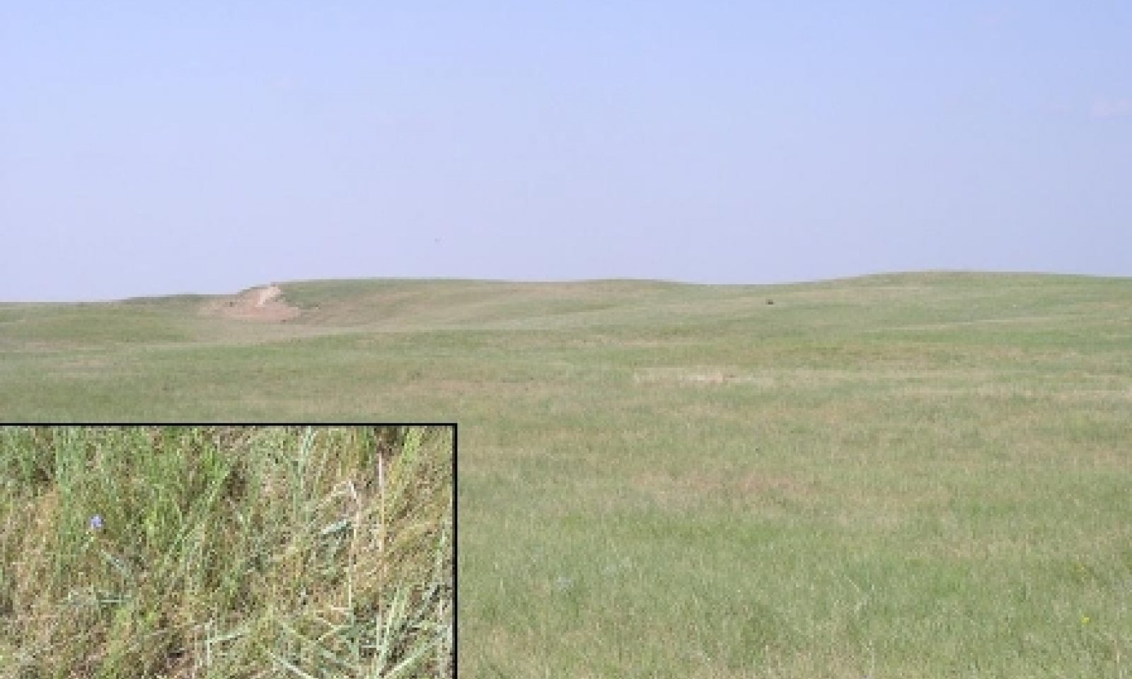
The Grassland State is supported by empirical data and is defined by two native plant communities that are a result of periodic fire, drought, herbivore, and ungulate grazers. These events are part of the natural disturbance regime and climatic process that contribute to the development of the site. The Reference Plant Community (1.1) consists of tall, mid, short, warm and cool-season grasses, forbs and shrubs. This plant community is dominated by tall and mid, warm-season grasses (65 percent composition by weight). The Midgrass-shortgrass, Increased Sand Sagebrush Plant Community (1.2) is dominated by blue grama, sand sagebrush, and little bluestem and is vulnerable to exceeding the resilience limits of the Grassland State and transitioning to the Shrub State .
A loss of plant cover and an increase in bare ground creates the probability of wind erosion. Drought-induced wind scouring coupled with disturbance (fire, continuous grazing, rodents, or vehicle traffic) can lead to blowouts and possibly an active dune. Extreme care should be taken when managing these areas. Ongoing field investigations and evaluations are necessary to assess the ecological communities in regard to resilience and changes in vegetation, soil, and hydrology of the site.
These plant communities may not represent every possibility, but they are the most prevalent and repeatable plant communities that exist on this ecological site. The plant composition table shown below has been developed from the best available knowledge at the time of this revision.
Submodel
Description
The Shrub State is supported by empirical data and is defined by one plant community phase.
The Reference Grassland State ecosystem has been driven beyond the limits of ecological resilience and has crossed a threshold into the Shrub State. The designation of the Shrub State denotes changes in plant species composition. This change in plant species negatively affects hydrology, forage production, and wildlife habitat, and increases erosion potential. Understory plants may be negatively affected by shrubs reducing the availability of light, soil moisture, and soil nutrients. As the size and density of shrubs increase, the cover and productivity of understory plants decrease. Desirable forage grasses are often the most severely reduced (Eddleman, 1983). As the vegetative cover changes from grasses to shrubs, more precipitation is lost via evaporation; therefore, less precipitation is available for producing herbaceous forage or for deep drainage or runoff (Thurow and Hester, 1997).
As shrubs increase, fine-fuel loads decrease. When shrub canopy increases to greater than 30 percent, significant biotic and soil changes have negatively impacted energy flow and the nutrient and hydrologic cycles. The processes and functions have shifted to favor the Shrubland State. Prescribed fire may become an ineffective tool to eradicate or decrease the shrubs due to the lack of fine fuel loads.
This alternative state should be tested through long-term observation of ecosystem behavior and repeated application of conservation and restoration practices.
Submodel
Description
The Reference Grassland State ecosystem has been driven beyond the limits of ecological resilience and has crossed a threshold into the Tillage State. The designation of the Tillage State denotes changes in infiltration, runoff, bulk density, aggregate stability and species composition. The changes in inherent soil properties, water movement and the plant community affect changes in hydrologic functionality, biotic integrity, and soil and site stability.
The Tillage State includes two community phases that are highly variable. These communities are derived through two distinct management scenarios and are not related successionally. Infiltration, runoff, and soil erosion vary depending on the vegetation present.
The Tillage State consists of abandoned cropland that has been naturally revegetated (go-back) or reseeded. Many were planted with a local seeding mix under the Conservation Reserve Program (CRP), or were planted to a monoculture of sideoats grama. Go-back communities are difficult to define due to the variability of plant communities that exist. Many of these communities are represented by threeawn species.
The Tillage State is an alternative state because the ecological functions, i.e. dynamic soil properties and plant communities, are not fully restored to that of the Grassland State. Tillage can destroy soil aggregation, which is an example of dynamic soil property change. Aggregate stability is critical for infiltration, root growth, and resistance to water and wind erosion (Brady and Weil 2008).
This alternative state should be tested through long-term observation of ecosystem behavior and repeated application of conservation and restoration practices.
Submodel
Mechanism
The triggers for this transition are long term (>30 years) management without a forage and animal balance, no prescription fires, heavy continuous grazing in the growing season and/or throughout the year, and inadequate recovery periods between grazing events. This type of management will convert the Grassland State to the Shrub State. Sand sagebrush is now the dominant species making up greater than 40 percent of the composition by weight. Due to the increased canopy cover of sand sagebrush there is less infiltration and an increase in raindrop interception during rainfall events. The hydrologic cycle and soil/site stability of the site are the ecological process affected.
Mechanism
This transition is triggered by a management action as opposed to a natural event. Mechanical tillage contributes directly to the loss of resilience and result in a shift between the Grassland State and the Tillage State. Ecological structure and function have been compromised. The effects of tillage include changes in soil structure, aggregate stability, bulk density, nutrient availability, plant cover, hydrologic function, and temperature.
This alternative state should be tested through long-term observation of ecosystem behavior and repeated application of conservation and restoration practices.
Mechanism
Management actions required to recover the grassland state include the removal of sand sagebrush to levels of approximately 10 percent canopy cover. Prescription fire might not be an option due to the lack of a fine fuel load. Chemical treatment of sand sagebrush is an option. Precautions and care should be taken when attempting this treatment method. The residual ecosystem properties, such as seed sources, species composition, nutrient content, and hydrologic properties, greatly influence the rate and probability of successful restoration and the management required for restoration pathways. Recommendations include a consultation and field evaluation prior to undertaking restoration activities. This restoration activity needs more field investigation and documentation.
Mechanism
This transition is triggered by a management action as opposed to a natural event. Mechanical tillage is the event that contributes directly to the loss of state resilience and is the result in a shift between the shrub state and the tillage state. Ecological structure and function have been compromised. The effects of tillage include changes in soil structure, aggregate stability, bulk density, nutrient availability, plant cover, hydrologic function, and temperature.
This alternative state should be tested through long-term observation of ecosystem behavior and repeated application of conservation and restoration practices. This state should be re-evaluated and refined continually.
Model keys
Briefcase
Add ecological sites and Major Land Resource Areas to your briefcase by clicking on the briefcase (![]() ) icon wherever it occurs. Drag and drop items to reorder. Cookies are used to store briefcase items between browsing sessions. Because of this, the number of items that can be added to your briefcase is limited, and briefcase items added on one device and browser cannot be accessed from another device or browser. Users who do not wish to place cookies on their devices should not use the briefcase tool. Briefcase cookies serve no other purpose than described here and are deleted whenever browsing history is cleared.
) icon wherever it occurs. Drag and drop items to reorder. Cookies are used to store briefcase items between browsing sessions. Because of this, the number of items that can be added to your briefcase is limited, and briefcase items added on one device and browser cannot be accessed from another device or browser. Users who do not wish to place cookies on their devices should not use the briefcase tool. Briefcase cookies serve no other purpose than described here and are deleted whenever browsing history is cleared.
Ecological sites
Major Land Resource Areas
The Ecosystem Dynamics Interpretive Tool is an information system framework developed by the USDA-ARS Jornada Experimental Range, USDA Natural Resources Conservation Service, and New Mexico State University.