Ecological dynamics
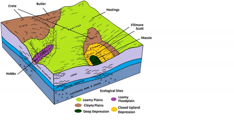
Closed Upland Depression sites occur as depressions in an upland position and are subject to ponding. The vegetation communities evolved under a disturbance regime that included periods of sporadic but often intensive grazing by large transient herbivores, and occasional wildfires. They are often referred to as buffalo wallows.
Hydroperiods are the driving force that controls the type and extent of vegetation communities within the sites. Because hydroperiod can vary year to year, the boundaries between communities can fluctuate as hydroperiod fluctuates. Vegetation also shifts as a result of different grazing and disturbance regimes. In general, disturbance promotes annual communities, while lack of disturbance promotes perennial communities.
Additionally, not all playas contain all possible communities; they may contain as few as one vegetation community. Similarly, wetland-upland interfaces are transient due to variable hydroperiods. During periods of above average precipitation, the wetland will move into the upland, while in periods of below average precipitation, the wetland will constrict.
Growth of native cool-season plants begins about April 1 and continues to about June 15. Native warm-season plants begin growth about May 15 and continue to about August 15. Green up of cool-season plants may occur in September and October if adequate moisture is available.
Land managers have begun to introduce the natural processes of grazing and fire when and where possible to create open areas that allow seed bearing annual plants to establish. These plants provide a critical food source for the millions of migratory birds that pass through the area annually. To facilitate reclamation of the more invaded sites, many managers have also begun using the more intensive practices of shredding, light disking, and applying herbicides.
Due to the small patch distribution of these sites and the degree of disturbance in the landscape, locating examples and reliable descriptions of examples of the pre-European reference plant community is difficult. The reference community description was determined by study of the best remaining relic examples, areas protected from excessive disturbance, research literature, expert opinions, and historical accounts.
Currently, five states are used to describe the Closed Upland Depression site, including the Reference State, Grassy Invaded State, Cattail/Bulrush Invaded State, Cropped Wetland State, and the Drained Wetland State. These states are based on anthropogenic alteration, hydroperiod, and disturbance regime and intensity.
The following diagram illustrates the states and the plant communities within the states that can occur on the site. The transitions between the states and between the communities are represented by the arrows. The processes that cause the fluctuation between the states and communities are discussed in more detail in the plant community descriptions following the diagram.
State 1
Reference State
The Reference State is dynamic and transitions between three vegetation communities. At any given time, a single wetland in the Reference State could have all three communities present or be dominated by a single community. The three communities that make up the Reference State are Reference Community, Moist Soil Perennial Community, and Moist Soil Annual Community. The spatial border between the three communities is directly linked to the duration and depth of ponding. This is driven seasonally, and by local rainfall events. Implementation of management practices like grazing, herbicide application, disking, shredding, haying, etc. can also influence community presence. Some of these areas may pond water long enough to drown out vegetation, leaving bare soil during dry cycles or sparse annual vegetation.
Implementation of management actions (e.g., prescribed fire, disking, haying, grazing, herbicide application) or the lack of disturbance can result in community phase changes within the reference state. In the absence of historical intensive grazing by bison and elk herds, and the disruption of the fire regime, land managers have intentionally engaged in practices to create and maintain a more disturbed phase within the reference state to achieve wildlife management goals.
The Reference State can transition to four other states as a result of human alteration (e.g., ditching or excavating concentration pits), very severe disturbance (e.g., plowing), and/or naturally occurring ecological processes. These other states include the Grassy Invaded State, Cattail/Bulrush Invaded State, Cropped Wetland State, and Drained Wetland State.
Community 1.1
Reference Community
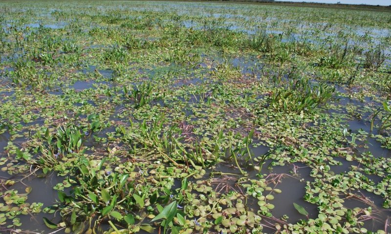
Figure 8. Reference Community
The Reference Community is also known as a saturated soil community. This community serves as the reference community in sites that have been inundated for extended periods of time. This zone is often characterized as a hemi-marsh. This community is often designated as a saturated soil perennial community. Dominant species in the hemi-marsh zone include arrowhead, bur-reed, native cattail, softstem bulrush, and water plantain.
As long as the site continues to be ponded and has moderate disturbance through grazing with adequate recovery periods, this community will persist. If the community has excessive sedimentation and lack of disturbance, it is susceptible to invasion by river bulrush, cattails, and if the hydroperiod decreases, reed canarygrass.
Under average climatic conditions, this community can be correlated to the Massie soil component of Closed Upland Depressions. The Massie soil is the major component of Massie map units and therefore this should be the dominant community of these delineations. It can be found as a minor inclusion in Scott map units and rarely in Fillmore map units. Excessive irrigation runoff can also promote the Saturated Soil Perennial Community regardless of soil type.
| Jan |
Feb |
Mar |
Apr |
May |
Jun |
Jul |
Aug |
Sep |
Oct |
Nov |
Dec |
| J |
F |
M |
A |
M |
J |
J |
A |
S |
O |
N |
D |
Community 1.2
Moist Soil Perennial Community
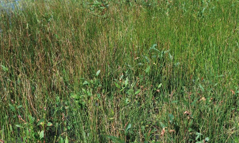
Figure 10. Moist Soil Perennial Community
The Moist Soil Perennial Community is the reference community for wetlands with saturated soil for extended periods or shallow ponding (i.e., <12 inches) intermittently. The dominant species for this community are spikerushes, sedges, rushes, western wheatgrass, foxtail barley, switchgrass, and annual and perennial smartweeds.
Moderate disturbance through grazing with adequate recovery periods or annual haying when the site is dry help maintain this community. If the site experiences excessive sedimentation, lack of disturbance, and an increase in ponding frequency and duration, this community is susceptible to invasion by bulrush and cattails. If the site experiences sedimentation, lack of disturbance, and a decrease in hydroperiod, then reed canarygrass can colonize the site.
Under average climatic conditions, this community can be correlated to the Scott soil component of Closed Upland Depressions. The Scott soil is the major component of Scott map units and therefore this should be the dominant community of these delineations. It can be found as a minor inclusion in Massie map units and Fillmore map units.
Community 1.3
Moist Soil Annual Community
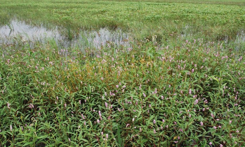
Figure 11. Moist Soil Annual Community
The Moist Soil Annual Community is the result of an intensive disturbance regime coupled with saturated soil for extended periods or shallow ponding intermittently. Common species include annual smartweeds, barnyardgrass, bidens, cocklebur, fall panicum, pigweeds, plains coreopsis, ragweeds, and sumpweed.
A heterogeneous mix of annual forbs and grasses provide ideal foraging habitat for migrating waterfowl during spring migration due to species diversity and high seed production of many of these species. Because of its habitat quality for migrating waterfowl, wildlife managers often focus efforts on creating and maintaining the Annual Moist Soil Community.
To promote and maintain this community, a variety of management treatments can be implemented. These treatments can include grazing, disking, and chemical application. If grazing is implemented, it needs to be conducted with a sufficient number of animals to remove aboveground biomass and create bare ground to promote germination of annual species. Animals should be removed from the site by July 15 to maximize time for plant growth and seed germination. If the site is rested for multiple years or has light to moderate annual disturbance, it will transition to a perennial community. If there is excessive sedimentation with an increase in ponding frequency bulrush and cattails can invade the site; if the site has excessive sedimentation and a normal hydroperiod, reed canarygrass can colonize the site.
Under average climatic conditions, this community can be correlated to the Fillmore soil component of Closed Upland Depressions. The Fillmore soil is the major component of Fillmore map units and therefore this should be the dominant community of these delineations. It can be found as a minor inclusion in Scott map units and rarely in Massie map units.
Pathway 1.1A
Community 1.1 to 1.2
Moist Soil Perennial Community
As saturated conditions subside with little additional disturbance, this community will transition to the Moist Soil Perennial Community. Annual haying and/or light grazing can also cause this transition.
Pathway 1.1B
Community 1.1 to 1.3
Moist Soil Annual Community
This community will shift to the Moist Soil Annual Community if the hydroperiod shortens and disturbance increases. Disturbance often involves the implementation of one or a combination of management treatments. Common management treatments include grazing, fire, shredding, disking, and spraying.
Pathway 1.2A
Community 1.2 to 1.1
Moist Soil Perennial Community
When ponding duration and depth (i.e., >12 inches) increases, this community can transition to the Saturated Soil Perennial Community. This generally occurs on sites that do not have a large sediment load and that routinely receive moderate disturbance.
Pathway 1.2B
Community 1.2 to 1.3
Moist Soil Perennial Community
Moist Soil Annual Community
Increased disturbance, such as disking, chemical application, and/or grazing, will shift this community to the Moist Soil Annual Community. For grazing to transition the community, it must be at a rate and intensity high enough to remove sufficient biomass and generate bare ground for germination of the annual species.
Pathway 1.3A
Community 1.3 to 1.1
Moist Soil Annual Community
When ponding duration and depth (>12 inches) increases and disturbance decreases, this community can transition to the Saturated Soil Perennial Community. This generally occurs on sites that do not have a large sediment load and routinely have light to moderate disturbance.
Pathway 1.3B
Community 1.3 to 1.2
Moist Soil Annual Community
Moist Soil Perennial Community
If this community remains undisturbed for several years, light to moderately grazed annually, and/or hayed annually, it will likely transition to the Moist Soil Perennial Community.
State 2
Grassy Invaded State
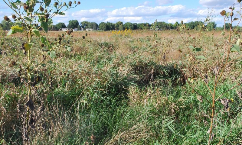
Figure 12. Grassy Invaded State - Reed Canarygrass Community
The Grassy Invaded State is dominated by reed canarygrass and generally occurs in areas that have little or no disturbance. Sites in the Grassy Invaded State may have been seeded to reed canarygrass or naturally colonized.
Annual haying and/or moderate grazing throughout the growing season with sufficient rest can promote dominant stands of reed canarygrass. Excessive sedimentation and/or areas in the wetland that have been land leveled with fill material can also promote the Grassy Invaded State. It has been hypothesized that the nutrient loads associated with sediment promotes vigorous growth of reed canarygrass. Saturated conditions and ponding generally less than 12 inches for prolonged periods also encourage Grassy Invaded State growth. Under average climatic conditions, this community can be correlated to the Fillmore and Scott soil components of Closed Upland Depressions.
The Fillmore soil is the major component of Fillmore map units and the Scott soil is the major component of Scott map units. Therefore, this may be the dominant community of these delineations. It can rarely be found as a minor inclusion in Massie map units. This community does occur in Massie map units when the associated watershed is significantly modified resulting in a more seasonal or temporary water regime.
The state consists of the Reed Canarygrass Community.
Community 2.1
Reed Canarygrass Community
This plant community is dominated by reed canarygrass and occurs when the site has little or no disturbance.
| Jan |
Feb |
Mar |
Apr |
May |
Jun |
Jul |
Aug |
Sep |
Oct |
Nov |
Dec |
| J |
F |
M |
A |
M |
J |
J |
A |
S |
O |
N |
D |
State 3
Cattail/Bulrush Invaded State
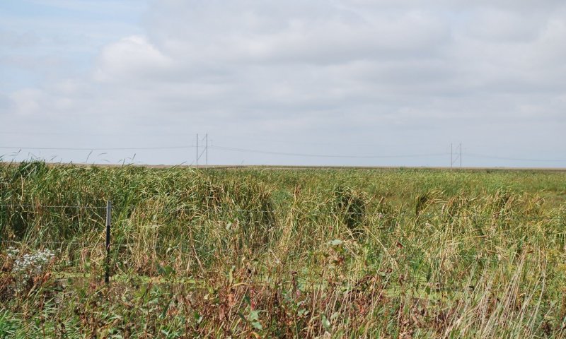
Figure 14. Cattail/Bulrush Invaded State
The Cattail/Bulrush Invaded State contains hybrid cattails and/or river bulrush. It generally occurs in wetlands that have little or no disturbance and ponding is deep, for long periods, and/or frequent. Hydrology of these sites generally promotes ponded conditions as a result of a highly functional watershed or supplemental water from irrigation runoff. Because of how wet these sites are, they are not routinely disturbed with grazing, disking, or haying. Sites that promote the Cattail/Bulrush Invaded State can have high sediment loads that provide excessive nitrogen and phosphorus. Under average climatic conditions in wetlands with intact watersheds, this community can be correlated to the Massie and Scott soil components of Closed Upland Depressions.
The Massie soil is the major component of Massie map units and the Scott soil is the major component of Scott map units. Therefore, this may be the dominant community of these delineations. It can rarely be found as a minor inclusion in Fillmore map units. Excessive irrigation runoff that results in a more semi-permanent water regime can allow this community to persist on Fillmore map units.
This state consists of the Cattail/River Bulrush Community.
Community 3.1
Cattail/River Bulrush Community
This plant community is dominated by hybrid cattails or river bulrush or both plants. It occurs when ponding is deep and/or frequent in combination with low levels of disturbance.
| Jan |
Feb |
Mar |
Apr |
May |
Jun |
Jul |
Aug |
Sep |
Oct |
Nov |
Dec |
| J |
F |
M |
A |
M |
J |
J |
A |
S |
O |
N |
D |
State 4
Cropped Wetland State
This state is actively cultivated and generally contains hydrologic modifications, such as concentration pits, excavation of surface drains or road ditches, and/or placement of fill material. Despite active cultivation and, generally, the presence of wetland modifications, these sites continue to pond water and grow hydrophytes.
State 5
Drained Wetland State
This state is actively cultivated and generally contains significant hydrologic modifications, such as concertation pits, excavation of surface drains or road ditches, and/or placement of fill material. Hydrologic modifications are so significant that hydrophytes rarely grow and ponding rarely occurs except, potentially, in a concentration pit. These sites are also generally cultivated.
Transition T1A
State 1 to 2
This transition occurs when the duration and intensity of disturbance is significantly reduced and where the hydrology promotes saturated conditions. Sites that have had a significant deposition of culturally accelerated sediment above the native soil profile can also transition to the Grassy Invaded State. This transition can also occur when sites are seeded to reed canarygrass.
Transition T1B
State 1 to 3
This transition occurs when disturbance is decreased to little or none and/or culturally accelerated sedimentation occurs. On areas that would normally be Moist Soil Annual or Moist Soil Perennial under average climatic conditions, ponding duration and frequency is increased through watershed restoration activities or as a result of excessive irrigation runoff. On areas that would normally be Saturated Soil Perennial, no change in hydroperiod is required.
Transition T1C
State 1 to 4
This transition occurs when the site is plowed or disked and planted to a commodity crop. The transition almost always requires wetland or watershed modifications. Some examples include excavation of concentration pits, construction of surface drains, placement of fill material within the hydric soil, and/or excessive sedimentation above the natural soil profile. Despite active cultivation and, generally, the presence of wetland modifications, the Cropped Wetland State continues to occasionally pond water and grow hydrophytes.
Transition T1D
State 1 to 5
The Drained Wetland State will result when significant wetland modifications are constructed to facilitate production agricultural practices. These sites rarely pond water outside of concentration pits.
Restoration pathway R2A
State 2 to 1
This transition occurs when the site receives a variety of disturbance treatments. A transition out of this state often requires a combination of spraying and disking treatments. The first spraying treatment kills a majority of the adult plants. A follow-up disking treatment kills the remaining adult plants and prepares the seedbank for germination of reed canarygrass seeds. A follow-up chemical treatment kills the sprouting seedlings. Maximum label rates of glyphosate approved for use over water have demonstrated good success. Both aerial and ground rig treatments have been successful for application. If sites are too wet to be successfully disked, heavy grazing in combination with chemical applications can be substituted. Restoration of hydrology may also be required to promote desired vegetation communities. If there is a large sediment load, heavy equipment can be used to excavate the material out of the wetland. Sediment surveys should be completed to determine the amount and location of the deposition.
Transition T2A
State 2 to 3
Cattail/Bulrush Invaded State
The transition from the Grassy Invaded Site to the Bulrush/Cattail Invaded State often results from an increase in hydroperiod. Ponding depth, duration, and/or frequency increase as a result of the extended hydroperiod. Cattail/Bulrush sites often also have an accumulation of sediment and are not routinely disturbed.
Transition T2B
State 2 to 4
This transition occurs when the site is plowed or disked and planted to a commodity crop. Usually, hydrologic modifications (e.g., concertation pits, excavation of surface drains or road ditches, and/or placement of fill material) are constructed to negatively impact hydroperiod and facilitate cultivation of crops. Despite active cultivation and, generally, the presence of wetland modifications, the Cropped Wetland State continues to occasionally pond water and grow hydrophytes.
Transition T2C
State 2 to 5
The Grassy Invaded State will transition to the Drained Wetland State if significantly modified to facilitate production agriculture practices. Common wetland modifications include excavation of concentration pits or surface drains, placement of fill material in the wetland or excessive sedimentation into the wetland. The Drained Wetland State sites rarely pond water outside of concentration pits.
Restoration pathway R3A
State 3 to 1
This transition occurs when the site receives a variety of disturbance treatments implemented over multiple years. If the site would naturally be Moist Soil Annual or Perennial, ponding duration and frequency is reduced. The transition from gravity to pivot irrigation or alternations in the watershed (i.e., excavation of road ditches) that reduce runoff to the wetland can promote this transition. If there is a large sediment load, heavy equipment can be used to excavate the material out of the wetland. Sediment surveys should be completed to determine the amount and location of the deposition. Once in the Reference State, the Saturated Soil Perennial Community usually dominates if no change in hydroperiod occurred. If a change in hydroperiod occurred, the site usually transitions to Moist Soil Annual Community due to increased disturbance.
Restoration pathway R3B
State 3 to 2
Cattail/Bulrush Invaded State
The transition from the Bulrush/Cattail Invaded State to the Grassy Invaded State often results from a decrease in hydroperiod. Sites that are not routinely disturbed and have an accumulation of sediment will often transition to the Grassy Invaded State.
Transition T3A
State 3 to 4
This transition occurs when the site is plowed or disked and planted to a commodity crop. Generally, hydrologic modifications (e.g., concertation pits, excavation of surface drains or road ditches, and/or placement of fill material) are constructed to negatively impact hydroperiod and facilitate cultivation of crops. Despite active cultivation and, generally, the presence of wetland modifications, the Cropped Wetland State site continues to pond water and grow hydrophytes such as barnyardgrass and smartweeds.
Transition T3B
State 3 to 5
State 3 will transition to State 5 if significantly altered by hydrologic modifications to facilitate production agricultural practices. The Drained Wetland State sites rarely pond water outside of concentration pits.
Restoration pathway R4A
State 4 to 1
This transition occurs as a result of the site no longer being cultivated. If hydrologic modifications are on site, wetland restoration is usually required. Wetland restoration actions often include filling concentration pits, plugging surface drains, and/or removing culturally accelerated sediment. After the site is no longer cultivated and restored, annual disturbance through grazing or other treatments can be implemented to maintain the Reference State. The Moist Soil Annual Community is the most likely community after cultivation and restoration due to the extreme disturbance caused by these activities.
Restoration pathway R4B
State 4 to 2
The transition of wetlands in the Cropped Wetland State to the Grassy Invaded State often occurs on those sites that are no longer cropped but are not routinely disturbed. If hydrologic modifications are on site, wetland restoration is usually required. This transition takes several years to occur post restoration because the extreme disturbance due to cultivation and restoration generally promotes the Moist Soil Annual Community initially.
Restoration pathway R4C
State 4 to 3
The transition of wetlands in the Cropped Wetland State to the Bulrush/Cattail Invaded State often occurs on those sites that are no longer cropped but are not routinely disturbed. For this transition to occur, the hydroperiod must be significantly increased and result in ponded water on the site. Hydroperiod can be increased by wetland restoration, an increase in natural precipitation for an extended period, or a change in surrounding land that increases runoff to the site (e.g., converting neighboring fields from dryland to gravity irrigation, or diverting a ditch into the wetland). Establishment of this state generally takes several years to occur post restoration because the extreme disturbance due to cultivation and restoration generally promotes the Moist Soil Annual Community initially.
Transition T4A
State 4 to 5
Transition from the Cropped Wetland Site to the Drained Wetland State is often the result of either constructing new wetland hydrologic modifications or maintenance of existing wetland drainage features. As a result of these features, sites have reduced wetland function and rarely pond water or grow hydrophytes.
Restoration pathway R5A
State 5 to 1
This transition occurs as a result of wetland restoration and change in landuse. Wetland restoration actions often include filling concentration pits, plugging surface drains, and/or removing culturally accelerated sediment. After restoration, disturbance regime and ponding frequency and duration will drive the vegetation state that occurs on the site. The Moist Soil Annual Community is the most likely community immediately after restoration due to the extreme disturbance caused by restoration.
Restoration pathway R5B
State 5 to 2
This transition occurs as a result of wetland restoration and change in landuse. Wetland restoration actions often include filling concentration pits, plugging surface drains, and/or removing culturally accelerated sediment. After restoration, disturbance regime and ponding frequency and duration will drive the vegetation state that occurs on the site. The Moist Soil Annual Community is the most likely community immediately after restoration due to the extreme disturbance caused by restoration.
Restoration pathway R5C
State 5 to 3
This transition occurs as a result of wetland restoration and change in landuse. Wetland restoration actions often include filling concentration pits, plugging surface drains, and/or removing culturally accelerated sediment. After restoration, disturbance regime and ponding frequency and duration will drive the vegetation state that occurs on the site. The Moist Soil Annual Community is the most likely community immediately after restoration due to the extreme disturbance caused by restoration.
Restoration pathway R5D
State 5 to 4
Transition from the Drained Wetland State to the Cropped Wetland State is often the result of wetland modifications failing, but the site remaining cropped. This has occurred when concentration pits have silted in resulting in lost storage capacity, or when tile drains have collapsed. With the reduced function of these modifications, wetland features will often pond water and grow hydrophytes.


