
Natural Resources
Conservation Service
Ecological site R083BY009TX
Clayey Bottomland
Last updated: 9/19/2023
Accessed: 04/02/2025
General information
Provisional. A provisional ecological site description has undergone quality control and quality assurance review. It contains a working state and transition model and enough information to identify the ecological site.
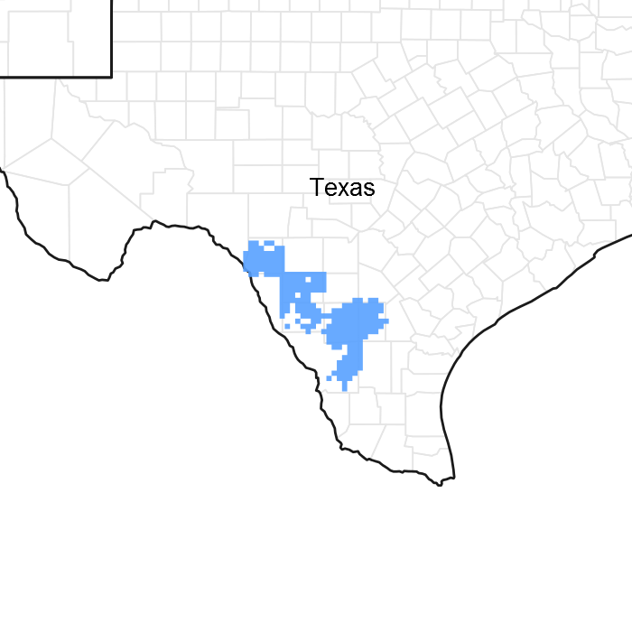
Figure 1. Mapped extent
Areas shown in blue indicate the maximum mapped extent of this ecological site. Other ecological sites likely occur within the highlighted areas. It is also possible for this ecological site to occur outside of highlighted areas if detailed soil survey has not been completed or recently updated.
MLRA notes
Major Land Resource Area (MLRA): 083B–Western Rio Grande Plain
Major Land Resource Area (MLRA) 83B It makes up about 9,285 square miles (24,060 square kilometers). The border towns of Del Rio, Eagle Pass, Laredo, and Zapata are in this MLRA. Interstate 35 crosses the area just north of Laredo. The Amistad National Recreation Area is just outside this MLRA, northwest of Del Rio, and the Falcon State Recreation Area is southeast of Laredo. Laughlin Air Force Base is just east of Del Rio. This area is comprised of inland, dissected coastal plains.
Classification relationships
USDA-Natural Resources Conservation Service, 2006.
-Major Land Resource Area (MLRA) 83B
Ecological site concept
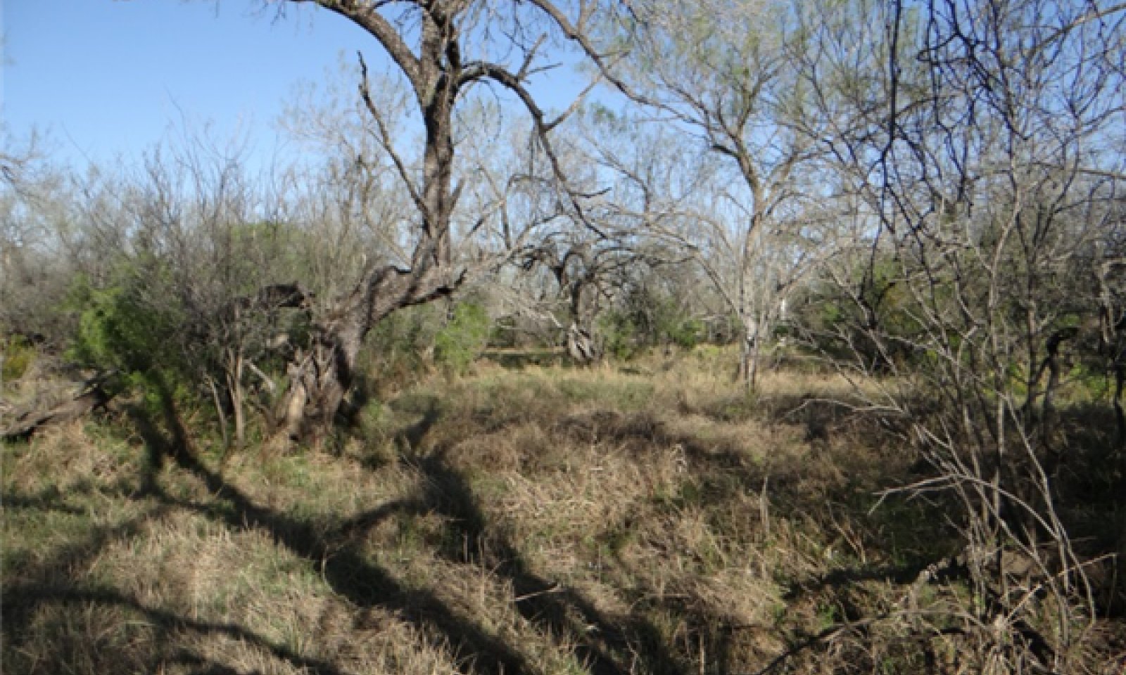
The Clayey Bottomland site is deep to very deep with clay surface textures occurring on flood plains. The soils are slightly alkaline and slightly saline.
Associated sites
| R083BY012TX |
Ramadero |
|---|---|
| R083BY016TX |
Saline Clay Loam |
Similar sites
| R083AY009TX |
Clayey Bottomland |
|---|---|
| R083DY009TX |
Clayey Bottomland |
Table 1. Dominant plant species
| Tree |
(1) Quercus virginiana |
|---|---|
| Shrub |
(1) Opuntia |
| Herbaceous |
(1) Trichloris pluriflora |
Physiographic features
This site occurs on low terraces of old flood plains. The setting is slightly depressed to nearly level areas that receive overflow about twice in every five years. Slopes are generally less than one percent. Elevation ranges from 165 to 1,200 feet. This area is comprised of inland, dissected coastal plains.
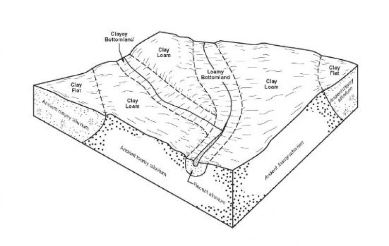
Figure 2.
Table 2. Representative physiographic features
| Landforms |
(1)
Coastal plain
> Flood plain
|
|---|---|
| Runoff class | Medium to very high |
| Flooding duration | Very brief (4 to 48 hours) to very long (more than 30 days) |
| Flooding frequency | None to frequent |
| Elevation | 43 – 366 m |
| Slope | 0 – 1% |
| Water table depth | 91 – 203 cm |
| Aspect | Aspect is not a significant factor |
Climatic features
MLRA 83B mainly has a subtropical steppe climate along the Rio Grande River and subtropical subhumid climates in La Salle and McMullen counties. Winters are dry and mild and the summers are hot. Tropical maritime air masses predominate throughout spring, summer and fall. Modified polar air masses exert considerable influence during winter, creating a continental climate characterized by large variations in temperature. Peak rainfall occurs late in spring and a secondary peak occurs early in fall. Most heavy thunderstorm activities occur during the summer months. July is hot and dry with little weather variations. Rainfall increases again in late August and September as tropical disturbances increase and become more frequent as the storms dissipate. Tropical air masses from the Gulf of Mexico dominate during the spring, summer and fall. Prevailing winds are southerly to southeasterly throughout the year except in December when winds are predominately northerly.
Table 3. Representative climatic features
| Frost-free period (characteristic range) | 231-321 days |
|---|---|
| Freeze-free period (characteristic range) | 313-365 days |
| Precipitation total (characteristic range) | 508 mm |
| Frost-free period (actual range) | 214-365 days |
| Freeze-free period (actual range) | 260-365 days |
| Precipitation total (actual range) | 483-533 mm |
| Frost-free period (average) | 270 days |
| Freeze-free period (average) | 340 days |
| Precipitation total (average) | 508 mm |
Figure 3. Monthly precipitation range
Figure 4. Monthly minimum temperature range
Figure 5. Monthly maximum temperature range
Figure 6. Monthly average minimum and maximum temperature
Figure 7. Annual precipitation pattern
Figure 8. Annual average temperature pattern
Climate stations used
-
(1) EAGLE PASS 3N [USC00412679], Eagle Pass, TX
-
(2) ZAPATA 1 S [USC00419976], Zapata, TX
-
(3) CRYSTAL CITY [USC00412160], Crystal City, TX
-
(4) LAREDO 2 [USC00415060], Laredo, TX
-
(5) DEL RIO INTL AP [USW00022010], Del Rio, TX
-
(6) CATARINA [USC00411528], Asherton, TX
-
(7) DEL RIO 2 NW [USC00412361], Del Rio, TX
-
(8) FALCON DAM [USC00413060], Roma, TX
Influencing water features
The Clayey Bottomlands occur on flood plains with overflow water. Flooding will occur occasionally to frequently lasting very brief to long durations.
Wetland description
Wetlands may occur near this site but typically this site is not a hydric soil and is not a wetland. If a wetland is suspected an onsite investigation is needed.
Soil features
The soils are very deep, moderately well to somewhat poorly drained with very slow permeability. The salinity ranges from non-saline to very slightly saline within the top 20 inches. Sodicity also increases with depth. Soil reaction is slightly alkaline or moderately alkaline. Surface color is grayish brown. Soil series correlated to this site include: Arroyada, Cochina, and Coquat.
Table 4. Representative soil features
| Parent material |
(1)
Alluvium
–
claystone
|
|---|---|
| Surface texture |
(1) Clay |
| Family particle size |
(1) Fine (2) Very-fine |
| Drainage class | Somewhat poorly drained to moderately well drained |
| Permeability class | Very slow |
| Soil depth | 203 cm |
| Surface fragment cover <=3" | 0% |
| Surface fragment cover >3" | 0% |
| Available water capacity (0-101.6cm) |
7.62 – 12.7 cm |
| Calcium carbonate equivalent (0-101.6cm) |
0 – 25% |
| Electrical conductivity (0-101.6cm) |
0 – 25 mmhos/cm |
| Sodium adsorption ratio (0-101.6cm) |
0 – 50 |
| Soil reaction (1:1 water) (0-101.6cm) |
7.4 – 8.4 |
| Subsurface fragment volume <=3" (Depth not specified) |
0 – 1% |
| Subsurface fragment volume >3" (Depth not specified) |
0% |
Ecological dynamics
The accounts of early explorers and settlers suggest that the Rio Grande Plains was likely a vast mosaic of open grassland, savannah, and shrubland. While moving in 1691 out of Maverick County and into Zavala County, Don Domingo de Teran found after crossing the Nueces River “the country was level and covered with mesquites and cats’ claw.” In 1849, Michler described south Texas as “concerning the land both on the Frio and the Leona, from these rivers back, that it may be divided into four parallel strips-the first, next to the river, consisting of heavy timber, and a heavy black soil, the second, a mesquite flat, of small width, and the soil of a lighter nature, and very fertile; the third, a range of low hills, covered with loose stones, and thick chaparral; the fourth, a wide-open prairie.” Lehman indicates, “thus while it is quite true that the Rio Grande Plains once had fewer woody plants and more grass than now, it is also true that an ample seed stock of shrubs and trees has been widely distributed for as long as man has known.” The vegetation structure likely varied from place-to-place depending on topography, soil properties, and time since the last major disturbance.
Large numbers of domestic livestock grazed South Texas as early as the mid-1700’s. Formal deeds to properties from the Spanish and Mexican governments came in the late 1760’s with much larger blocks granted in the decades to follow. Lehman indicated, “in 1757, the official Spanish census showed residents of Camargo and Reynosa in the lower Rio Grande owning over 90,000 sheep and goats. By way of contrast, combined numbers of cattle, oxen, horses, mules and burros were less than 16,000.” By the mid-1800’s, according to Lehman’s figures from the U. S. Census of 1889, “there were a minimum of 1,644,268 sheep-fully 45 percent of Texas total population, grazing south of the Nueces River.” According to Inglis, “the Rio Grande Plains had the four-leading sheep producing counties in the state and ten of the top fifteen sheep producing counties were in South Texas. The peak decade was 1880 to 1890, at times exceeding two million head.” These domestic animals were in addition to bison, antelope, deer, and large herds of wild horses. It is obvious from early accounts, that much of the Rio Grande Plains was periodically grazed hard by both domestic animals and wild populations as early as the early to mid-1700’s. It may be that overgrazing by sheep and goats could have suppressed the many shrubs, reduced shrub canopy, and arrested shrub seedlings.
With the arrival of European man, the South Texas area was fenced and, in many instances, stocked beyond its capability to sustain forage. This overstocking led to a reduced fire frequency and intensity, creating an opportunity for woody shrubs to increase across the landscape. As the natural graze-rest cycles were altered and stocking rates continued to exceed the natural carrying capacity of the land, midgrasses were replaced by shortgrasses and the ground cover was opened so additional annual and perennial forbs also increased. Drought certainly enhanced this effect. As prolonged overgrazing continued, shrub cover increased. Shortgrasses became dominant and forage production decreased. This change in plant cover and structure further decreased fire frequency and intensity, favoring shrub establishment and dominance.
The plant communities of this site are dynamic varying in relation to fire, periodic drought, and wet cycles. Periodic fires were set by either Native Americans or started naturally by lightning. Fire did not play as important a role on this site as in deeper more productive sites due to lower production of grasses to burn. Because of large amounts of gravel in the soil, available water holding capacity is greatly reduced. This causes highly variable forage production and minimal grass production during dry years. The historic community of this site was influenced to some extent by periodic grazing by herds of buffalo and wild horses. Herds of buffalo and wild horses would come into an area, graze it down, and then not come back for many months or even years depending upon the availability of water. This long deferment period allowed recovery of the grasses and forbs which served as fuel load. More than likely, fire occurred following years of good rainfall followed by a dry season. The fire frequency for this area is interpreted to be four to six years (Frost, 1998).
State and transition model
More interactive model formats are also available.
View Interactive Models
Click on state and transition labels to scroll to the respective text
Ecosystem states
| T1A | - | Absence of disturbance and natural regeneration over time, coupled with excessive grazing pressure |
|---|---|---|
| T1B | - | Extensive soil disturbance followed by seeding improved forage species |
| R2A | - | Reintroduction of historic disturbance return intervals |
| T2A | - | Extensive soil disturbance followed by seeding improved forage species |
| T3A | - | Absence of disturbance and natural regeneration over time |
State 1 submodel, plant communities
State 2 submodel, plant communities
State 3 submodel, plant communities
State 1
Savannah
The Savannah State consisted of approximately 70 percent grasses, 20 percent woody plants and a 10 percent composition of forbs by air-dry weight. For interpretive purposes, the woody crown canopy can be approximately 10 to 40 percent. Two community phases exist; the Tallgrass Savannah Community and the Mixedgrass Savannah Community.
Dominant plant species
-
cedar elm (Ulmus crassifolia), tree
-
multiflower false Rhodes grass (Trichloris pluriflora), grass
-
southwestern bristlegrass (Setaria scheelei), grass
Community 1.1
Tallgrass Savannah

Figure 9. 1.1 Tallgrass Savannah Community on the Cochina series. Photo by Dusty Crowe, NRCS, 2014.
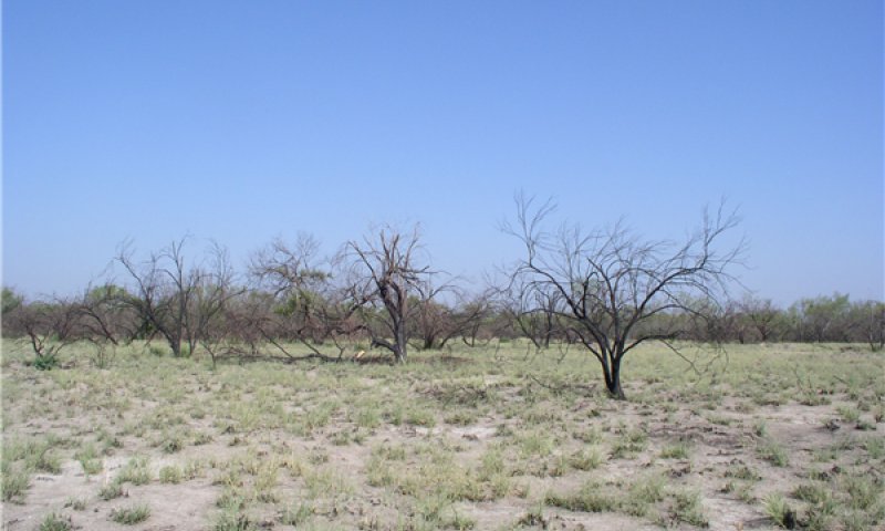
Figure 10. Big scaton following burn. Photo by Jason Hohlt, NRCS, 2013.
The reference community is a tallgrass savannah with some shrub. Bunchgrasses such as multiflowered false Rhodes grass (Trichloris pluriflora), southwestern bristlegrass (Setaria scheelei), big cenchrus (Cenchrus myosuroides), and big sacaton (Sporobolus wrightii) are the major species. Immediately adjacent to stream channels, large woody riparian plants are common such as cedar elm (Ulmus crassifolia), liveoak (Quercus virginiana), bumelia (Sideroxylon lanuginosum), anacua (Ehretia anacua), and mesquite (Prosopis glandulosa). Higher in the flood plain, large mesquites tend to dominate the woody canopy. Underneath heavily shaded areas, cool-season grasses such as Texas wintergrass (Nasella leucotricha) and Virginia wildrye (Elymus virginicus) ocuur. Occasional out-of-bank flow provides extra soil moisture and nutrients while also depositing sediments. This community was maintained by periodic grazing by wild populations and numerous fires; both natural and anthropogenic. Fire likely played more of a role on this site as distance from the primary stream channel increased. Fire frequency is perceived to be variable and to occur in above average years followed by drought and/or prolonged dormant periods. The site is productive and maintained a high percentage of ground cover most of the time. During extended droughts, this ground cover of perennial grasses and forbs was often greatly reduced but had the resiliency to recover when favorable climatic conditions returned. While periodic grazing was a natural component of the ecosystem, continuous abusive grazing has a strong negative impact on this site. Because of abusive grazing, the tallgrasses decrease and are replaced by less palatable, short-lived grasses. Droughts hasten the process. Major grass increasers are white tridens (Tridens muticus), vine mesquite (Panicum obtusum), buffalograss, curly mesquite (Hilaria belangeri) and pink pappusgrass (Pappophorum bicolor). Mesquite, twisted acacia (Acacia schaffneri), whitebrush (Aloysia gratissima), and prickly pear (Opuntia spp.) are the common woody plants that increase as abusive grazing persists. This site, because of the water afforded by landscape position, has the potential to recover much faster than adjacent uplands. However, it will still take several years for a satisfactory recovery. Any efforts to recover this plant community should also consider the proper management of the adjacent upland sites as they are interdependent.
Figure 11. Annual production by plant type (representative values) or group (midpoint values)
Table 5. Annual production by plant type
| Plant type | Low (kg/hectare) |
Representative value (kg/hectare) |
High (kg/hectare) |
|---|---|---|---|
| Grass/Grasslike | 3363 | 5604 | 7846 |
| Tree | 673 | 897 | 1121 |
| Shrub/Vine | 112 | 224 | 336 |
| Forb | 56 | 168 | 280 |
| Total | 4204 | 6893 | 9583 |
Table 6. Ground cover
| Tree foliar cover | 0-5% |
|---|---|
| Shrub/vine/liana foliar cover | 5-10% |
| Grass/grasslike foliar cover | 75-95% |
| Forb foliar cover | 5-15% |
| Non-vascular plants | 0% |
| Biological crusts | 0% |
| Litter | 80-100% |
| Surface fragments >0.25" and <=3" | 0% |
| Surface fragments >3" | 0% |
| Bedrock | 0% |
| Water | 0% |
| Bare ground | 0-10% |
Table 7. Canopy structure (% cover)
| Height Above Ground (m) | Tree | Shrub/Vine | Grass/ Grasslike |
Forb |
|---|---|---|---|---|
| <0.15 | 0-2% | 1-2% | 70-100% | 1-10% |
| >0.15 <= 0.3 | 0-2% | 1-4% | 70-100% | 1-15% |
| >0.3 <= 0.6 | 0-2% | 1-4% | 60-80% | 5-20% |
| >0.6 <= 1.4 | 1-4% | 1-5% | 30-50% | 5-15% |
| >1.4 <= 4 | 2-5% | 1-5% | – | – |
| >4 <= 12 | 5-10% | – | – | – |
| >12 <= 24 | – | – | – | – |
| >24 <= 37 | – | – | – | – |
| >37 | – | – | – | – |
Figure 12. Plant community growth curve (percent production by month). TX5125, Midgrass Grassland Community. Warm-season production from grass, forbs, and woody species..
| Jan | Feb | Mar | Apr | May | Jun | Jul | Aug | Sep | Oct | Nov | Dec |
|---|---|---|---|---|---|---|---|---|---|---|---|
| J | F | M | A | M | J | J | A | S | O | N | D |
| 1 | 1 | 5 | 15 | 20 | 20 | 5 | 5 | 10 | 10 | 5 | 3 |
Community 1.2
Mixedgrass Savannah
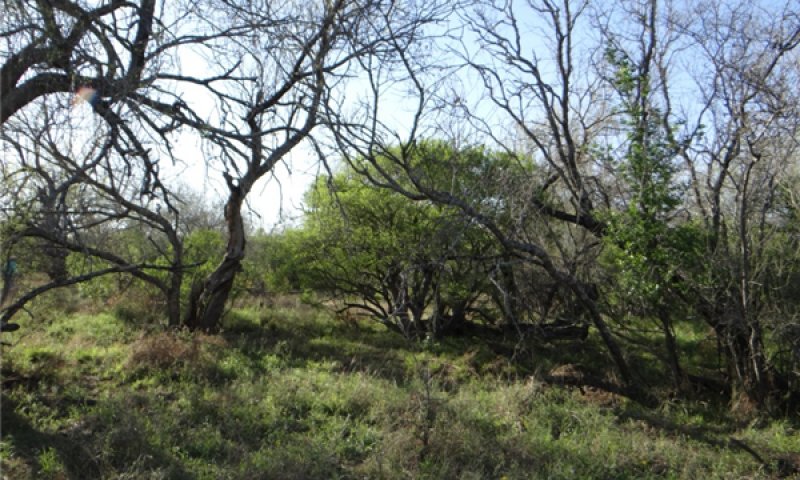
Figure 13. 1.2 Mixedgrass Savannah
This community still exhibits a savannah plant structure dominated by trees, but with a shift to fewer tallgrasses such as multiflowered false Rhodes grass, southwestern bristlegrass, big cenchrus, and big sacaton. Cool-season grasses such as Texas wintergrass and Virginia wildrye increase with the shade from increasing canopy. Large woody plants like cedar elm, liveoak, bumelia, anacua, and mesquite have increased in height and canopy. In the understory, there is an increase of shrubs such as twisted acacia, whitebrush, granjeno and Texas persimmon. While periodic grazing was a natural component of the ecosystem, continuous abusive grazing has a strong negative impact on this site. Because of abusive grazing, the tallgrasses decrease and are of reduced vigor. Fire every three to five years will move this community back toward the Tallgrass Savannah Community as there are still enough remnant tallgrasses to respond. A significant role for prescribed grazing is to not only restore vigor to the tallgrasses, but also to build and maintain fine fuel amounts for effective prescribed burning. It will be increasingly difficult to use fire as canopy and cool-season plants increase. Integrated brush management treatment is needed to restore the community.
Figure 14. Annual production by plant type (representative values) or group (midpoint values)
Table 8. Annual production by plant type
| Plant type | Low (kg/hectare) |
Representative value (kg/hectare) |
High (kg/hectare) |
|---|---|---|---|
| Grass/Grasslike | 2242 | 3923 | 5604 |
| Tree | 673 | 897 | 1121 |
| Forb | 168 | 280 | 392 |
| Shrub/Vine | 112 | 224 | 336 |
| Total | 3195 | 5324 | 7453 |
Figure 15. Plant community growth curve (percent production by month). TX5128, Shortgrass Dominant Community. Shortgrass dominates the site with decreasing midgrasses and increasing shrubs..
| Jan | Feb | Mar | Apr | May | Jun | Jul | Aug | Sep | Oct | Nov | Dec |
|---|---|---|---|---|---|---|---|---|---|---|---|
| J | F | M | A | M | J | J | A | S | O | N | D |
| 1 | 1 | 5 | 15 | 20 | 21 | 5 | 5 | 10 | 10 | 5 | 2 |
Pathway 1.1A
Community 1.1 to 1.2


A shift to the Mixedgrass Savannah Community occurs if the Tallgrass Savannah Community is weakened by excessive leaf removal. Drought hastens the process. A reduction in tall and midgrasses also corresponds in a reduction of fuel loading needed for fire to effectively suppress woody species.
Pathway 1.2A
Community 1.2 to 1.1


Managerial activities that restore the hydrologic cycle, the energy capture by tall grasses, and ground cover will move the 1.2 Mixedgrass Savannah Community toward the 1.1 Tallgrass Savannah Community. Utilizing historic ecological disturbances such as herbivory and fire in constructive amounts is needed. Selective brush management may also be needed. The time to shift back to the 1.1 Tallgrass Savannah Community certainly is dependent upon favorable growing conditions and could take 5 to 10 years. Landscape position with occasional flooding can increase recovery of this plant community quicker than adjacent upland sites.
Conservation practices
| Brush Management | |
|---|---|
| Prescribed Burning | |
| Prescribed Grazing |
State 2
Shrubland
The Woodland/Shrubland state consists of two communities; Tree/Shrubland Community (2.1) with a brush canopy of 40-70 percent, and the Tree/Shrubland Community (2.2) with a brush canopy of >70 percent. These communities are mixed grass communities with a shrub canopy of mixed brush and trees with some herbaceous plants throughout the interspaces.
Dominant plant species
-
cedar elm (Ulmus crassifolia), tree
Community 2.1
Shrubland
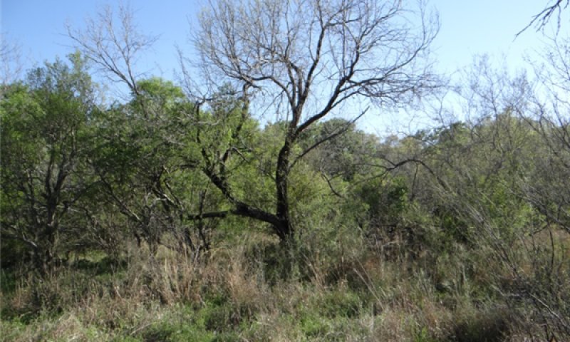
Figure 16. 2.1 Shrubland Community. Photo by Jason Hohlt, NRCS, 2013.
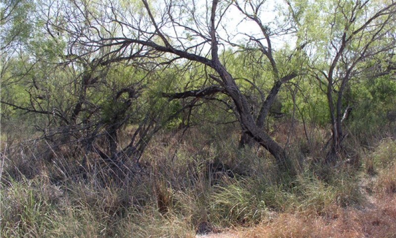
Figure 17. Pocket of big sacaton. Photo by Jason Hohlt, NRCS, 2013.
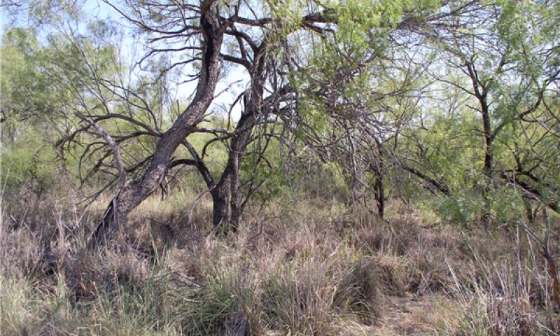
Figure 18. Mesquite canopy of 40 to 70 percent. Photo by Jason Holht, NRCS, 2013.
Shrubs have increase significantly as has overstory canopy in the Shrubland Ccommunity. Once woody plants establish and increase on these fertile soils, competition is greatly reduced. At this point, prescribed grazing alone will not restore this community back to the Savanna State (1). Trees and shrubs are very competitive for sunlight, moisture, and nutrients. Flushes of annual forbs can occur throughout the entire year in response to episodic rainfall. Prescribed fire will be a limited option in this community because of a lack of fine fuel load, fuel continuity, and brush cover. Some pockets of the taller grasses such as big sacaton exist, especially where there are saline spots and grazing pressure is light. Unless brush management is done, shrub cover will increase to more than 50 percent canopy. In areas that tend to pond water on this site, spiny aster (Chloracantha spinosa) may establish and form dense colonies. Aggressive brush and grazing management is required to restore the system back to the Savannah State. Re-seeding of perennial warm-season grasses may be necessary and has potential to speed up the restoration process. Reseeding may also have potential to limit establishment of aggressive, introduced grasses such as Kleberg bluestem (Dichanthium annualatum).
Figure 19. Annual production by plant type (representative values) or group (midpoint values)
Table 9. Annual production by plant type
| Plant type | Low (kg/hectare) |
Representative value (kg/hectare) |
High (kg/hectare) |
|---|---|---|---|
| Grass/Grasslike | 560 | 1121 | 1681 |
| Tree | 673 | 897 | 1121 |
| Forb | 224 | 504 | 785 |
| Shrub/Vine | 224 | 392 | 560 |
| Total | 1681 | 2914 | 4147 |
Figure 20. Plant community growth curve (percent production by month). TX5130, Short/Midgrass Shrubland Complex 20-50% woody canopy. Shrubland Community with 20-50% woody canopy..
| Jan | Feb | Mar | Apr | May | Jun | Jul | Aug | Sep | Oct | Nov | Dec |
|---|---|---|---|---|---|---|---|---|---|---|---|
| J | F | M | A | M | J | J | A | S | O | N | D |
| 2 | 2 | 5 | 10 | 18 | 15 | 5 | 9 | 15 | 9 | 5 | 5 |
Community 2.2
Woodland
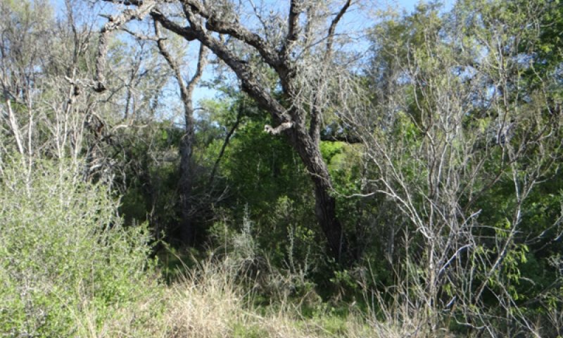
Figure 21. 2.2 Woodland Community. Photo by Jason Hohlt, NRCS, 2013.
A lack of brush management of any kind has allowed this community to develop. At this point, prescribed grazing alone will not restore this community. The understory of shrubs provide a second layer of woody canopy that approaches and exceeds 70 percent. Trees and shrubs now harvest most of the sunlight, moisture, and nutrients. Flushes of annual forbs can occur throughout the entire year in response to episodic rainfall. Prescribed fire is not a viable option in this community because of a lack of fine fuel, fuel continuity, and brush cover. Unless brush management is done, shrub cover will increase to more than 50 percent. Aggressive brush and grazing management is required to restore the system back to the grassland state. Re-seeding of perennial warm-season grasses may be necessary and has potential to speed up the restoration process. Reseeding may also have potential to limit establishment of aggressive, introduced grasses such as Kleberg bluestem.
Figure 22. Annual production by plant type (representative values) or group (midpoint values)
Table 10. Annual production by plant type
| Plant type | Low (kg/hectare) |
Representative value (kg/hectare) |
High (kg/hectare) |
|---|---|---|---|
| Grass/Grasslike | 224 | 673 | 1121 |
| Shrub/Vine | 448 | 785 | 1121 |
| Tree | 673 | 897 | 1121 |
| Forb | 224 | 392 | 560 |
| Total | 1569 | 2747 | 3923 |
Figure 23. Plant community growth curve (percent production by month). TX5130, Short/Midgrass Shrubland Complex 20-50% woody canopy. Shrubland Community with 20-50% woody canopy..
| Jan | Feb | Mar | Apr | May | Jun | Jul | Aug | Sep | Oct | Nov | Dec |
|---|---|---|---|---|---|---|---|---|---|---|---|
| J | F | M | A | M | J | J | A | S | O | N | D |
| 2 | 2 | 5 | 10 | 18 | 15 | 5 | 9 | 15 | 9 | 5 | 5 |
Pathway 2.1A
Community 2.1 to 2.2


A shift to the Woodland Community (2.2) occurs if no brush management is done. Drought hastens the process. A lack of brush management allows existing brush to gain in stature. Seedlings are introduced through droppings of livestock and wildlife. A reduction in tall and midgrasses also corresponds to a reduction of fuel loading needed for fire to effectively suppress woody species. Although the potential of fire is questionable at this point.
Pathway 2.2A
Community 2.2 to 2.1


Managerial activities that restore the hydrologic cycle, the energy capture by grasses, and restoring ground cover will tend to move the 2.2 Woodland Community toward the 2.1 Shrubland Community. Selective brush management is needed to accomplish the desired canopy level and spatial arrangement of woody species. Integrated brush management and utilizing historic ecological disturbances such as herbivory and fire in constructive amounts is needed to maintain the desired brush densities. The time to shift back to the 2.1 Shrubland Community is dependent upon favorable growing conditions and could take 3 to 5 years.
Conservation practices
| Brush Management | |
|---|---|
| Prescribed Burning | |
| Prescribed Grazing |
State 3
Converted Land
The Converted Land State is the result of mechanical intervention along with range planting to either native or adapted introduced species.
Dominant plant species
-
buffelgrass (Pennisetum ciliare), grass
Community 3.1
Converted Land
This plant community is developed by applying brush management and seeding. The conversion can actually come from any of the previously mentioned communities where brush needs to be reduced and a seed source added to establish a desired plant community. In some instances, an adequate seed source may already exist in the soil. When rootplowing is applied as brush management on this site, long term forb and woody plant diversity will be greatly reduced. Previous attempts at native seeding in this region were met with mixed results because of the seed source not being locally adapted to the region. Many of the grass species listed in the reference plant community are commercially available from collections made in south Texas. The locally adapted species are expected to be more successful in seeding efforts as compared to seed developed several hundred miles outside the region. However, proper seedbed preparation, planting techniques, and timely rainfall are essential for success. The most common introduced grass species seeded is buffelgrass (Cenchrus ciliare). Seeding this species should be cautiously considered due to its aggressive nature to dominate plant communities and reduce herbaceous diversity. Once planted, conversion of buffelgrass dominated areas back to native grass is extremely difficult and rarely successful. The decision of which species to seed is a management decision based on clearly defined goals for livestock and wildlife. Careful consideration should be taken prior to seeding introduced species. Once introduced species are seeded, it is often difficult or impractical to remove them should objectives change. Because of the residual seed source of woody plants, encroachment is inevitable. To help maintain this plant community, prescribed grazing along with fire and some integrated brush management will be needed.
Figure 24. Annual production by plant type (representative values) or group (midpoint values)
Table 11. Annual production by plant type
| Plant type | Low (kg/hectare) |
Representative value (kg/hectare) |
High (kg/hectare) |
|---|---|---|---|
| Grass/Grasslike | 3363 | 5044 | 6725 |
| Tree | 673 | 897 | 1121 |
| Forb | 112 | 280 | 448 |
| Shrub/Vine | 112 | 224 | 336 |
| Total | 4260 | 6445 | 8630 |
Figure 25. Plant community growth curve (percent production by month). TX5133, Converted Land Community - Native Grass Seeding. Developed by applying brush management, land clearing and seeding to any of the other plant communities where brush needs to be reduced and a seed source added to establish the desired plant community. .
| Jan | Feb | Mar | Apr | May | Jun | Jul | Aug | Sep | Oct | Nov | Dec |
|---|---|---|---|---|---|---|---|---|---|---|---|
| J | F | M | A | M | J | J | A | S | O | N | D |
| 2 | 2 | 5 | 10 | 18 | 15 | 5 | 9 | 15 | 9 | 5 | 5 |
Community 3.2
Abandoned Land
This community develops from the Converted Land Community (3.1) through neglect or abandonment. Without follow-up brush management, seedlings of shrubs establish and spread. Mesquite, twisted acacia, and pricklypear are the most common woody plants or shrubs found on this site following rootplowing. Maintaining healthy grass cover on the site through prescribed grazing might slow brush seedling encroachment however, brush encroachment at some rate is inevitable. If the seedlings are not managed, the plant community will cross a threshold to the Shrubland State (2) which will require application of chemical or mechanical brush management to reduce the canopy. If left untreated too long, reseeding might be needed to restore the grass. As the canopy of the shrubs expands, grass and forb production will be reduced.
Figure 26. Annual production by plant type (representative values) or group (midpoint values)
Table 12. Annual production by plant type
| Plant type | Low (kg/hectare) |
Representative value (kg/hectare) |
High (kg/hectare) |
|---|---|---|---|
| Grass/Grasslike | 224 | 1513 | 2802 |
| Shrub/Vine | 448 | 785 | 1121 |
| Tree | 673 | 897 | 1121 |
| Forb | 224 | 392 | 560 |
| Total | 1569 | 3587 | 5604 |
Figure 27. Plant community growth curve (percent production by month). TX5138, Converted Land Community - Woody Seedling Encroachment. Abandoned croplands and land seeded with exotic or native grasses are prone to encroachment by woody plants and with heavy grazing or the absence of fire, can revert to shrublands..
| Jan | Feb | Mar | Apr | May | Jun | Jul | Aug | Sep | Oct | Nov | Dec |
|---|---|---|---|---|---|---|---|---|---|---|---|
| J | F | M | A | M | J | J | A | S | O | N | D |
| 2 | 2 | 5 | 10 | 18 | 15 | 5 | 9 | 15 | 9 | 5 | 5 |
Pathway 3.1A
Community 3.1 to 3.2
If woody species are not managed by integrated methods such as brush management or fire, the woody species will increase. Once woody species exceed about 10 percent canopy, it will be difficult to manage them at economic levels.
Pathway 3.2A
Community 3.2 to 3.1
An integrated effort with fire and brush management is needed to restore this community to a grassland. Range planting may also be needed. Grazing management is essential to restore the competitiveness of the grasses and to maintain fuel load needed for effective burning.
Conservation practices
| Brush Management | |
|---|---|
| Prescribed Burning | |
| Range Planting | |
| Prescribed Grazing |
Transition T1A
State 1 to 2
The Savannah State will cross a threshold to Shrubland State with abusive grazing, no brush management, or fire. Severe drought is also a significant factor to accelerate this transition. In State 2, more rainfall is being utilized by woody plants than the herbaceous plants. Because of the increased canopy, sunlight is being captured by the woody plants and converted to energy instead of the herbaceous plants.
Transition T1B
State 1 to 3
The transition to the Converted Land State is triggered by major ground disturbing mechanical treatment and planting to native or introduced forages. Planting is usually done following brush management.
Restoration pathway R2A
State 2 to 1
If the management goal is to restore to State 1, significant inputs of energy will be needed. An integrated approach to Brush Management (Scifres et. al. 1985) with mechanical treatment, herbicides and fire will initially reduce the woody species providing opportunity for at least partial recovery of the hydrologic cycle and the energy cycle. Seeding may be needed and can be done in conjunction with ground disturbance methods of brush management. A return to State 1 within a management time frame will be next to impossible when considering returning the trees to their original stature.
Conservation practices
| Brush Management | |
|---|---|
| Prescribed Burning | |
| Range Planting | |
| Prescribed Grazing |
Transition T2A
State 2 to 3
The transition to the Converted Land State is triggered by major ground disturbing mechanical treatment and planting to native or introduced forages. Planting is usually done following brush management.
Transition T3A
State 3 to 2
The transition from the Converted Land State to the Shrubland State is triggered by neglect or no management over long periods of time. Shrubs re-establish from the seed bank and introduction from wildlife and livestock. A complete return to a previous state is not possible if adapted, non-native plants have been established or if the soil health has significantly deteriorated. It will also take 20 to 30 years for the large trees to return.
Additional community tables
Table 13. Community 1.1 plant community composition
| Group | Common name | Symbol | Scientific name | Annual production (kg/hectare) | Foliar cover (%) | |
|---|---|---|---|---|---|---|
|
Grass/Grasslike
|
||||||
| 1 | Warm season bunchgrasses | 3138–5828 | ||||
| big sacaton | SPWR2 | Sporobolus wrightii | 0–5828 | – | ||
| switchgrass | PAVI2 | Panicum virgatum | 0–5604 | – | ||
| big sandbur | CEMY | Cenchrus myosuroides | 0–5044 | – | ||
| southwestern bristlegrass | SESC2 | Setaria scheelei | 0–5044 | – | ||
| multiflower false Rhodes grass | TRPL3 | Trichloris pluriflora | 448–2690 | – | ||
| large-spike bristlegrass | SEMA5 | Setaria macrostachya | 0–1121 | – | ||
| 2 | Warm season mid/shortgrasses | 224–2018 | ||||
| pink pappusgrass | PABI2 | Pappophorum bicolor | 0–1121 | – | ||
| buffalograss | BODA2 | Bouteloua dactyloides | 0–897 | – | ||
| curly-mesquite | HIBE | Hilaria belangeri | 0–897 | – | ||
| white tridens | TRAL2 | Tridens albescens | 0–336 | – | ||
| Madagascar dropseed | SPPY2 | Sporobolus pyramidatus | 0–224 | – | ||
| 3 | cool season bunch grasses | 224–2018 | ||||
| Texas wintergrass | NALE3 | Nassella leucotricha | 0–1121 | – | ||
| sedge | CAREX | Carex | 0–336 | – | ||
|
Forb
|
||||||
| 4 | Forbs | 56–280 | ||||
| bluestem pricklypoppy | ARAL3 | Argemone albiflora | 0–56 | – | ||
| spiny chloracantha | CHSP11 | Chloracantha spinosa | 0–56 | – | ||
| Cuman ragweed | AMPS | Ambrosia psilostachya | 0–56 | – | ||
| bundleflower | DESMA | Desmanthus | 0–45 | – | ||
| plains dozedaisy | APRA | Aphanostephus ramosissimus | 0–34 | – | ||
| littleleaf sensitive-briar | MIMI22 | Mimosa microphylla | 0–34 | – | ||
| wild petunia | RUELL | Ruellia | 0–34 | – | ||
| annual bushsunflower | SILA11 | Simsia lagasceiformis | 0–34 | – | ||
| vervain | VERBE | Verbena | 0–34 | – | ||
| globemallow | SPHAE | Sphaeralcea | 0–22 | – | ||
| fanpetals | SIDA | Sida | 0–22 | – | ||
| sand phacelia | PHPA4 | Phacelia patuliflora | 0–22 | – | ||
| groundcherry | PHYSA | Physalis | 0–22 | – | ||
| pepperweed | LEAP6 | Lepidium apetalum | 0–22 | – | ||
|
Shrub/Vine
|
||||||
| 5 | Shrub/Vines | 112–336 | ||||
| whitebrush | ALGR2 | Aloysia gratissima | 0–224 | – | ||
| Texas persimmon | DITE3 | Diospyros texana | 0–168 | – | ||
| lotebush | ZIOB | Ziziphus obtusifolia | 0–112 | – | ||
| saltbush | ATRIP | Atriplex | 0–56 | – | ||
| guajillo | ACBE | Acacia berlandieri | 0–56 | – | ||
| blackbrush acacia | ACRI | Acacia rigidula | 0–56 | – | ||
| stretchberry | FOPU2 | Forestiera pubescens | 0–56 | – | ||
| Texas lignum-vitae | GUAN | Guaiacum angustifolium | 0–56 | – | ||
| Berlandier's wolfberry | LYBE | Lycium berlandieri | 0–56 | – | ||
| pricklypear | OPUNT | Opuntia | 11–56 | – | ||
| desert yaupon | SCCU4 | Schaefferia cuneifolia | 0–56 | – | ||
| lime pricklyash | ZAFA | Zanthoxylum fagara | 0–56 | – | ||
|
Tree
|
||||||
| 6 | Trees | 673–1121 | ||||
| live oak | QUVI | Quercus virginiana | 224–673 | – | ||
| honey mesquite | PRGL2 | Prosopis glandulosa | 168–448 | – | ||
| cedar elm | ULCR | Ulmus crassifolia | 168–448 | – | ||
| knockaway | EHAN | Ehretia anacua | 0–336 | – | ||
| Mexican ash | FRBE | Fraxinus berlandieriana | 0–336 | – | ||
| common buttonbush | CEOC2 | Cephalanthus occidentalis | 0–224 | – | ||
| gum bully | SILA20 | Sideroxylon lanuginosum | 0–224 | – | ||
Interpretations
Animal community
As a historic tall/midgrass prairie, this site was occupied by bison, antelope, deer, quail, turkey, and dove. This site was also used by many species of grassland songbirds, migratory waterfowl, and coyotes. This site now provides forage for livestock and is still used by quail, dove, migratory waterfowl, grassland birds, coyotes, and deer.
Feral hogs (Sus scrofa) can be found on most ecological sites in Texas. Damage caused by feral hogs each year includes, crop damage by rutting up crops, destroyed fences, livestock watering areas, and predation on native wildlife. Feral hogs have few natural predators, thus allowing their population to grow to high numbers.
Wildlife habitat is a complex of many different plant communities and ecological sites across the landscape. Most animals use the landscape differently to find food, shelter, protection, and mates. Working on a conservation plan for the whole property, with a local professional, will help managers make the decisions that allow them to realize their goals for wildlife and livestock.
Grassland State (1): This state provides the maximum amount of forage for livestock such as cattle. It is also utilized by deer, quail and other birds as a source of food. When a site is in the reference plant community phase (1.1) it will also be used by some birds for nesting, if other habitat requirements like thermal and escape cover are near.
Tree/Shrubland (2): This state can be maintained to meet the habitat requirements of cattle and wildlife. Land managers can find a balance that meets their goals and allows them flexibility to manage for livestock and wildlife. Forbs for deer and birds like quail will be more plentiful in this state. There will also be more trees and shrubs to provide thermal and escape cover for birds as well as cover for deer.
Converted Land State (3): The quality of wildlife habitat this site will produce is extremely variable and is influenced greatly by the timing of rain events. This state is often manipulated to meet landowner goals. If livestock production is the main goal, it can be converted to pastureland. It can also be planted to a mix of grasses and forbs that will benefit both livestock and wildlife. A mix of forbs in the pasture could attract pollinators, birds and other types of wildlife. Food plots can also be planted to provide extra nutrition for deer.
This rating system provides general guidance as to animal preference for plant species. It also indicates possible competition between kinds of herbivores for various plants. Grazing preference changes from time to time, especially between seasons, and between animal kinds and classes. Grazing preference does not necessarily reflect the ecological status of the plant within the plant community. For wildlife, plant preferences for food and plant suitability for cover are rated. Refer to habitat guides for a more complete description of a species habitat needs.
Hydrological functions
The water cycle on this site functions according to the management of not only the existing plant community but also of the surrounding plant communities. The water cycle is most functional when the site is dominated by tall bunchgrass and native trees as the site functions much the same as a sponge. Rapid rainfall infiltration, high soil organic matter, good soil structure, and good porosity are present with a good cover of bunchgrass. Quality of surface runoff will be high, while erosion and sedimentation rates will be low. With high rates of infiltration and periods of heavy rainfall, some water will move below the root zone of grasses. As this water moves downward it may contribute to the recharge of some aquifers.
When unmanaged grazing causes loss or reduction of bunchgrass and ground cover, the water cycle becomes impaired. Infiltration is decreased and runoff is increased because of poor ground cover, rainfall splash, soil capping, low organic matter, and poor structure. With a combination of a sparse ground cover and intensive rainfall, this site can contribute to an increased frequency and severity of flooding within a watershed. Soil erosion is accelerated, quality of surface runoff is poor, and sedimentation is increased.
As the site becomes dominated by woody species, especially oaks, mesquite, and shrubs, the water cycle is further altered. Interception of rainfall by tree canopies is increased which reduces the amount of rainfall reaching the surface (Thurow and Hester, 1997). Stem flow is increased, however, because of the funneling effect of the canopy by the oaks and mesquite. This increases soil moisture at the base of the tree. Increased transpiration, especially when evergreen species like live oak dominate and provide less chance for deep percolation into aquifers. As woody species increase, grass cover declines, which causes some of the same results as heavy grazing.
Various brush management components can help restore the natural hydrology of the site. Also, critical to the overall health of the Clayey Bottomland is the existence of healthy streamside or riparian vegetation. These small but very important vegetative communities exist in the transition zone between the upland portion of the site and the creeks or streams.
Many important functions come from a healthy riparian plant community. These communities protect the streambanks during flooding much the same as shingles protect a roof. They also trap sediments, deadfall, and nutrients fostering the building of soils and nutrients. Another function is that of a sponge, absorbing water and slowly releasing it over time leading to a more sustained flow. These small areas also provide diverse grazing for livestock.
If a mature woodland canopy develops, a buildup of leaf litter occurs which increases the organic matter of the soil, builds structure, improves infiltration, and retards erosion. Some, but not all values of a properly functioning water cycle are restored on this site when a woodland plant community persists.
Recreational uses
Hunting and bird watching are common activities.
Wood products
Cutting hardwoods for firewood is the main wood product on this site.
Supporting information
Inventory data references
Information presented was derived from the revised Range Site, literature, limited NRCS clipping data (417s), field observations, and personal contacts with range-trained personnel.
Other references
Archer, S. 1995. Herbivore mediation of grass-woody plant interactions. Tropical Grasslands, 29:218-235.
Archer, S. 1995. Tree-grass dynamics in a Prosopis-thornscrub savanna parkland: reconstructing the past and predicting the future. Ecoscience, 2:83-99.
De Leon, A. 2003. Itineraries of the De Léon Expeditions of 1689 and 1690. In Spanish Exploration in the Southwest, 1542-1706. Edited by H. E. Bolton. Charles Scribner’s Sons, New York, NY.
Dillehay T. 1974. Late quaternary bison population changes on the Southern Plains. Plains Anthropologist, 19:180-96.
Duaine, C. L. 1971. Caverns of Oblivion. Packrat Press, Oak Harbor, WA.
Everitt, J. H., D. L. Drawe, and R. I. Leonard. 2002. Trees, Shrubs, and Cacti of South Texas. Texas Tech University Press, Lubbock, TX.
Everitt, J. H., D. L. Drawe, and R. I. Lonard. 1999. Field Guide to the Broad-Leaved Herbaceous Plants of South Texas. Texas Tech University Press. Lubbock, TX.
Frost, C. C. 1998. Presettlement fire frequency regimes of the United States: a first approximation. In Fire in ecosystem management: shifting the paradigm from suppression to prescription. Tall Timbers Fire Ecology Conference Proceedings. 20:70-81.
Gilbert, L. E. 1982. An ecosystem perspective on the role of woody vegetation, especially mesquite, in the Tamaulipan biotic region of South Texas. Proceeding Symposium of the Tamaulipan Biotic Province, Corpus Christi, TX.
Hanselka, W., R. Lyons, and M. Moseley. 2009. Grazing Land Stewardship: A Manual for Texas Landowners. Texas AgriLife Extension Service, College Station, TX.
Hart, C. R., T. Garland, A. C. Barr, B. B. Carpenter, and J.C. Reagor. 2003. Toxic Plants of Texas: Integrated Management Strategies to Prevent Livestock Losses. Texas Cooperative Extension Bulletin B-6103 11-03.
Heitschmidt R. K., Stuth J. W., eds. 1991. Grazing management: an ecological perspective. Timberline Press, Portland, OR.
Inglis, J. M. 1964. A history of vegetation of the Rio Grande Plains. Texas Parks and Wildlife Department Bulletin No. 45, Austin, TX.
Lehman, V. W. 1969. Forgotten legions: sheep in the Rio Grande Plains of Texas. Texas Western Press, University of Texas at El Paso, El Paso, TX.
McGinty A., D. N. Ueckert. 2001. The Brush Busters success story. Rangelands, 23:3-8.
McLendon T. 1991. Preliminary description of the vegetation of South Texas exclusive of coastal saline zones. Texas Journal of Science, 43: 13-32
Norwine, J. 1978. Twentieth-century semiarid climates and climatic fluctuations in Texas and northeastern Mexico. Journal of Arid Environments, 1:313-325.
Norwine, J. and R. Bingham. 1986. Frequency and severity of droughts in South Texas: 1900-1983, 1-17. In Livestock and wildlife management during drought. Edited by R. D. Brown. Caesar Kleberg Wildlife Research Institute, Kingsville, TX.
Parvin, R. W. 2003. Rio Bravo Resource Conservation and Development. Llanos Mestenos South Texas Heritage Trail. Zapata, TX.
Scifres, C. J. and W. T. Hamilton. 1993. Prescribed burning for brushland management: the South Texas example. Texas A&M Press, College Station, TX.
Scifres C. J., W. T. Hamilton, J. R. Conner, J. M. Inglis, and G. A. Rasmussen. 1985. Integrated Brush Management Systems for South Texas: Development and Implementation. Texas Agricultural Experiment Station, College Station, TX.
Texas Parks and Wildlife Department. 2007. List of White-tailed Deer Browse and Ratings. District 8.
Thurow, T. L. and J. W. Hester. 1997. How an increase or reduction in juniper cover alters rangeland hydrology. Juniper Symposium Proceedings. Texas A&M University, San Angelo, TX.
Weltz, M. A. and W. H. Blackburn. 1995. Water budget for south Texas rangelands. Journal of Range Management, 48:45-52.
Wright, B. D., R. K. Lyons, J. C. Cathey, and S. Cooper. 2002. White-tailed deer browse preferences for South Texas and the Edwards Plateau. Texas Cooperative Extension Bulletin B-6130.
Approval
Bryan Christensen, 9/19/2023
Acknowledgments
Reviewers and Contributors:
Vivian Garcia, RMS, NRCS, Corpus Christi, Texas
Jason Hohlt, RMS, NRCS, Kingsville, Texas
Forrest Smith, South Texas Natives, Kingsville, Texas
Dusty Crowe, DC, NRCS, Carrizo Springs, Texas
Gary Harris, MSSL, NRCS, Robstown, Texas
Shanna Dunn, RSS, NRCS, Corpus Christi, Texas
Ann Kinney, Editor, NRCS, Temple, Texas
Mark Moseley, ESS, NRCS, San Antonio, Texas
Rangeland health reference sheet
Interpreting Indicators of Rangeland Health is a qualitative assessment protocol used to determine ecosystem condition based on benchmark characteristics described in the Reference Sheet. A suite of 17 (or more) indicators are typically considered in an assessment. The ecological site(s) representative of an assessment location must be known prior to applying the protocol and must be verified based on soils and climate. Current plant community cannot be used to identify the ecological site.
| Author(s)/participant(s) | Vivian Garcia, RMS, NRCS, Corpus Christi, Texas |
|---|---|
| Contact for lead author | 361-241-0609, Corpus Christi Zone Office |
| Date | 04/02/2015 |
| Approved by | Bryan Christensen |
| Approval date | |
| Composition (Indicators 10 and 12) based on | Annual Production |
Indicators
-
Number and extent of rills:
None. -
Presence of water flow patterns:
None. -
Number and height of erosional pedestals or terracettes:
None. -
Bare ground from Ecological Site Description or other studies (rock, litter, lichen, moss, plant canopy are not bare ground):
Small and non-connected areas. -
Number of gullies and erosion associated with gullies:
None. -
Extent of wind scoured, blowouts and/or depositional areas:
None. -
Amount of litter movement (describe size and distance expected to travel):
Short, less than one foot except during overflow events. -
Soil surface (top few mm) resistance to erosion (stability values are averages - most sites will show a range of values):
Soil Stability Rating of 5 to 6. -
Soil surface structure and SOM content (include type of structure and A-horizon color and thickness):
Subangular blocky, A-horizon 4 to 12 inches, three percent SOM. -
Effect of community phase composition (relative proportion of different functional groups) and spatial distribution on infiltration and runoff:
Tall and midgrasses reduce runoff to minimal amounts except in exceptional rainfall events. -
Presence and thickness of compaction layer (usually none; describe soil profile features which may be mistaken for compaction on this site):
None. -
Functional/Structural Groups (list in order of descending dominance by above-ground annual-production or live foliar cover using symbols: >>, >, = to indicate much greater than, greater than, and equal to):
Dominant:
Warm season tall grasses>>Sub-dominant:
short warm season grasses (SD)> cool season grasses (SD)>perennial forbs(SD)> trees=shrubs (SD). Forbs make up 10 percent species composition, shrubs and trees compose up to 10 percent.Other:
Additional:
-
Amount of plant mortality and decadence (include which functional groups are expected to show mortality or decadence):
None. -
Average percent litter cover (%) and depth ( in):
-
Expected annual annual-production (this is TOTAL above-ground annual-production, not just forage annual-production):
3,750 to 8,550 air-dry pounds per acre. -
Potential invasive (including noxious) species (native and non-native). List species which BOTH characterize degraded states and have the potential to become a dominant or co-dominant species on the ecological site if their future establishment and growth is not actively controlled by management interventions. Species that become dominant for only one to several years (e.g., short-term response to drought or wildfire) are not invasive plants. Note that unlike other indicators, we are describing what is NOT expected in the reference state for the ecological site:
King Ranch bluestem, spiny aster, mesquite, twisted acacia, annual forbs, annual panicums, threeawns, and red grama. -
Perennial plant reproductive capability:
All plants should reproduce each year.
Print Options
Sections
Font
Other
The Ecosystem Dynamics Interpretive Tool is an information system framework developed by the USDA-ARS Jornada Experimental Range, USDA Natural Resources Conservation Service, and New Mexico State University.
Click on box and path labels to scroll to the respective text.
Ecosystem states
| T1A | - | Absence of disturbance and natural regeneration over time, coupled with excessive grazing pressure |
|---|---|---|
| T1B | - | Extensive soil disturbance followed by seeding improved forage species |
| R2A | - | Reintroduction of historic disturbance return intervals |
| T2A | - | Extensive soil disturbance followed by seeding improved forage species |
| T3A | - | Absence of disturbance and natural regeneration over time |