
Natural Resources
Conservation Service
Ecological site R085BY083OK
Shallow Upland 38-42 PZ
Last updated: 9/21/2023
Accessed: 02/08/2026
General information
Provisional. A provisional ecological site description has undergone quality control and quality assurance review. It contains a working state and transition model and enough information to identify the ecological site.
Figure 1. Mapped extent
Areas shown in blue indicate the maximum mapped extent of this ecological site. Other ecological sites likely occur within the highlighted areas. It is also possible for this ecological site to occur outside of highlighted areas if detailed soil survey has not been completed or recently updated.
MLRA notes
Major Land Resource Area (MLRA): 085B–Arbuckle Uplift
The Grand Prairie MLRA is characterized by predominately loam and clay loam soils underlain by limestone and shale. Topography transitions from steeper ridges and summits of the Lampasas Cut Plain on the southern end to the more rolling hills of the Fort Worth Prairie to the north. The Arbuckle Mountain area in Oklahoma is also within this MLRA. In the structurally complex Arbuckle Mountains of southern Oklahoma, outcropping rocks are primarily limestone, sandstone, dolomite, quartzite, and chert. These units are exposed as alternating beds of Paleozoic rocks that have been faulted, tilted, and deformed to form a tombstone-like topography. This area has significant exposures of granite, rhyolite, and gabbro of Precambrian age.
Classification relationships
This ecological site is correlated to soil components at the Major Land Resource Area (MLRA) level which is further described in USDA AgHandbook 296.
Ecological site concept
These sites occur on shallow, cobbly, clay loam soils weathered from limestone conglomerate. The soils associated with these sites can be quite productive but may be more susceptible to drought conditions than loamy sites. The reference vegetation includes midgrasses and a variety of forbs and legumes. Few woody species occur when in reference condition. However, in the absence of fire or other brush management woody species will increase across the site.
Associated sites
| R085BY056OK |
Loamy Upland 38-42 PZ Moderately deep loamy soils on uplands. |
|---|
Similar sites
| R085AY185TX |
Shallow 30-38" PZ Similar soils in the southern portion of Grand Prairie |
|---|
Table 1. Dominant plant species
| Tree |
Not specified |
|---|---|
| Shrub |
Not specified |
| Herbaceous |
(1) Bouteloua curtipendula |
Physiographic features
This site occurs on side slopes, nose slopes, and crests of hillslopes in the Arbuckle Uplift. This site is characteristically a water distributing site.
Table 2. Representative physiographic features
| Landforms |
(1)
Hills
> Hillslope
|
|---|---|
| Runoff class | Medium to high |
| Elevation | 650 – 1,300 ft |
| Slope | 5 – 20% |
| Aspect | Aspect is not a significant factor |
Climatic features
The climate is moist subhumid with average annual rainfall from 38 to 42 inches per year. The highest percentages in rainfall occur during April, May and June. More years of below average rainfall can be expected than those above average. Winters are characterized by mild temperatures with occasional “Northers” which can produce severe cold for short periods of time. Average wind velocities can be high in the Southern Great Plains during February, March and April causing erosion on unprotected surfaces.
Table 3. Representative climatic features
| Frost-free period (characteristic range) | 187-200 days |
|---|---|
| Freeze-free period (characteristic range) | 204-224 days |
| Precipitation total (characteristic range) | 39-42 in |
| Frost-free period (actual range) | 184-207 days |
| Freeze-free period (actual range) | 201-225 days |
| Precipitation total (actual range) | 38-42 in |
| Frost-free period (average) | 194 days |
| Freeze-free period (average) | 212 days |
| Precipitation total (average) | 41 in |
Figure 2. Monthly precipitation range
Figure 3. Monthly minimum temperature range
Figure 4. Monthly maximum temperature range
Figure 5. Monthly average minimum and maximum temperature
Figure 6. Annual precipitation pattern
Figure 7. Annual average temperature pattern
Climate stations used
-
(1) CHICKASAW NRA [USC00341745], Sulphur, OK
-
(2) ARDMORE [USC00340292], Ardmore, OK
-
(3) ADA [USC00340017], Ada, OK
-
(4) PAULS VALLEY 4 WSW [USC00346926], Pauls Valley, OK
-
(5) MADILL [USC00345468], Madill, OK
Influencing water features
These sites shed water to lower adjacent areas.
Wetland description
NA
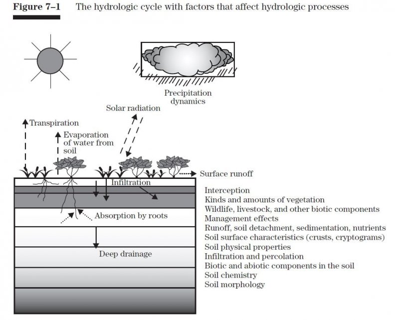
Figure 8.
Soil features
Representative soil components for this ecological site include: Rayford
The site is characterized by well drained calcareous soils weathered from conglomerate. These soils are shallow, well drained, moderately permeable prairie soils that formed in material weathered from limestone conglomerate of Pennsylvanian age.
Table 4. Representative soil features
| Parent material |
(1)
Residuum
–
conglomerate
|
|---|---|
| Surface texture |
(1) Cobbly loam |
| Drainage class | Well drained |
| Permeability class | Moderate |
| Soil depth | 8 – 20 in |
| Surface fragment cover <=3" | 2% |
| Surface fragment cover >3" | 5 – 50% |
| Available water capacity (0-40in) |
1 – 2 in |
| Calcium carbonate equivalent (0-40in) |
10% |
| Electrical conductivity (0-40in) |
2 mmhos/cm |
| Sodium adsorption ratio (0-40in) |
Not specified |
| Soil reaction (1:1 water) (0-40in) |
6.6 – 8.4 |
| Subsurface fragment volume <=3" (Depth not specified) |
5 – 20% |
| Subsurface fragment volume >3" (Depth not specified) |
20 – 45% |
Ecological dynamics
Like many sites across the Great Plains, changes in disturbance initiated by permanent settlements has had a profound impact on the ecological dynamics of these sites. Historically, the site was influenced by periodic fires during all seasons of growth. These fires were often the result of dry lightning strikes and/or anthropogenic fires set by Native Americans. The fire frequency during the period prior to settlement is estimated between 2-5 years for the southern Great Plains. These frequent fires were often followed by grazing of migratory bison herds attracted to the new growth of grass. This led to a shifting mosaic between burned/grazed and unburned and ungrazed landscapes.
With the removal of fire and the introduction of conventional livestock fencing, the landscape began to change to more homogenous vegetation patterns and altered plant communities. This led to a highly fragmented, highly disturbed landscape we see today across much of the area.
Less fire tolerant woody species are more prevalent in many areas due to fire suppression and/or the use of strictly dormant season fires. Abusive grazing can shift the plant community to less palatable grass species and lead to an increase in opportunistic forbs. Heavy grazing can also reduce fine fuel load and limit the ability to conduct a prescribed fire.
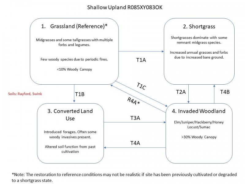
State and Transitional Pathways:
The following diagram suggests some pathways that vegetation on the site might take in response to various treatments or natural stimuli over time. There may be other states that are not shown on this diagram. This information identifies the changes in plant communities that do occur due to management practices and natural factors. The plant communities described here are commonly observed on this ecological site. The local NRCS field office has information available to assist with planning and development of the plant community for specific purposes.
Changes in plant community makeup may be due to many factors. Change may occur slowly or in some cases, fairly rapidly. As vegetative changes occur, certain thresholds are crossed. A threshold means that once a certain point is reached during the transition of one community to another, a return to the previous state may not be possible without the input of some form of energy. This often means intervention with practices that are not part of natural processes. An example might be the application of herbicide to control some woody species to reduce their population and encourage more grass and forbs growth. Merely adjusting grazing practices would probably not accomplish any significant change in a plant community once certain thresholds are crossed. The amount of energy required to effect change in community would depend on the present vegetative state and the desired change.
State and transition model
More interactive model formats are also available.
View Interactive Models
Click on state and transition labels to scroll to the respective text
State 1 submodel, plant communities
State 1
Grassland - Reference

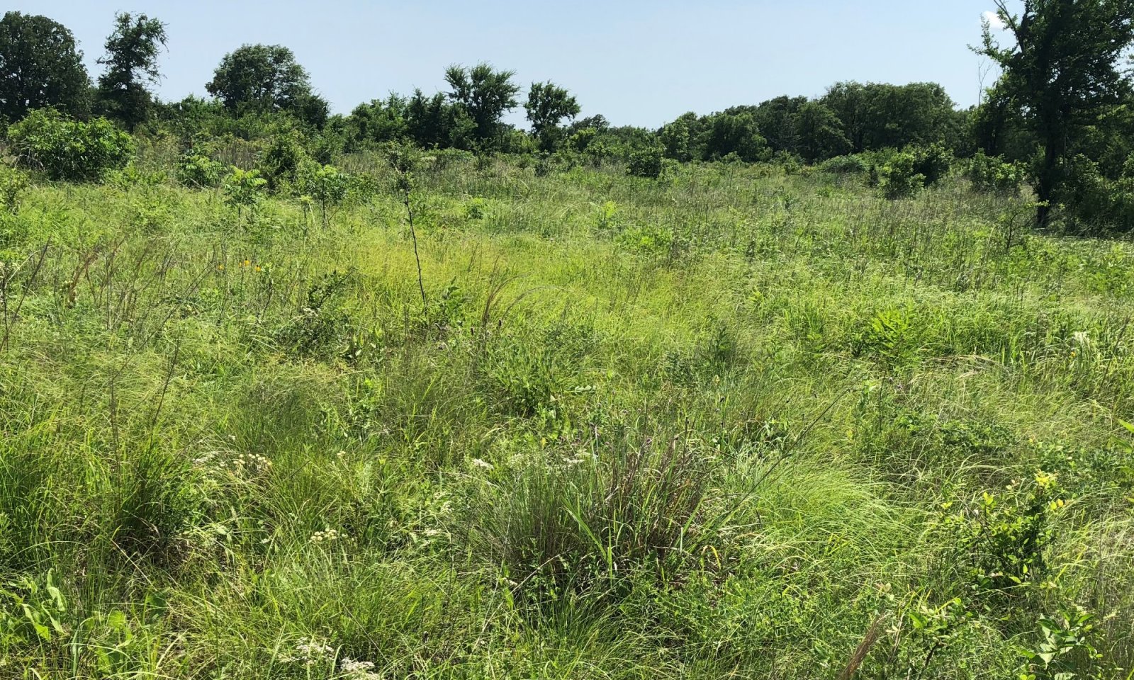
Figure 9. Rayford soils with brush encroaching. Murray County, OK
This is the reference state for the Shallow Upland ecological site. It represents the historic range of variability in the plant communities with the periodic disturbance of fire and grazing. It is dominated by herbaceous plants with few woody species. The dominant grasses are sideoats grama, big bluestem, Indiangrass, switchgrass and little bluestem. Other grasses include Texas cupgrass, dropseeds, silver bluestem, hairy grama, blue grama and Scribner’s panicum. Dominant forbs include, western ragweed, heath aster, poppymallows and trailing ratany. Legumes include wild indigo, prairie clovers, scurfpea, and native lespedezas. Few woody species persist in reference condition but may include sumacs, sand plum, coralberry, persimmon and skunkbush. The Shallow Upland site is estimated to produce between 1,500 – 3,000 pounds of vegetative production per year in reference condition. Tallgrasses = Midgrasses greater than Forbs Shrubs and Trees are a minor component of these sites.
Dominant plant species
-
sideoats grama (Bouteloua curtipendula), grass
Community 1.1
Figure 10. Annual production by plant type (representative values) or group (midpoint values)
Table 5. Annual production by plant type
| Plant type | Low (lb/acre) |
Representative value (lb/acre) |
High (lb/acre) |
|---|---|---|---|
| Grass/Grasslike | 1275 | 1870 | 2550 |
| Forb | 150 | 220 | 300 |
| Shrub/Vine | 60 | 88 | 120 |
| Tree | 15 | 22 | 30 |
| Total | 1500 | 2200 | 3000 |
State 2
Shortgrass
This state represents a change in the dominant plant community. Shortgrasses such as buffalograss, blue grama and hairy gramma have formed a sod-like plant community. There are many areas of bare ground and opportunistic annuals such as annual threewn and common broomweed are abundant. Precipitation runoff is high and infiltration is low which leads to low soil moisture and reduced production.
Dominant plant species
-
buffalograss (Bouteloua dactyloides), grass
State 3
Converted Land Use
This state represents a change in land use from rangeland to pastureland. The soil structure and biology has been altered and the site is dominated by introduced species. Management of introduced forages requires more inputs than native grasses. Careful consideration should be taken prior to planting to ensure the result meets the desired use. Ratings for forage yields can be found under the non-irrigated crop yield section in web soil survey. As with any fertility management program, current soil tests should be taken before planting and subsequent fertilization of introduced pastures. The most common forage species on these sites include Bermudagrass and Old World Bluestems(eg. KR Bluestem). Without brush management, woody species such as mesquites, junipers, elms, or honey locust may invade these sites. There may be opportunities to plant native grass species on these sites to restore the reference plant communities. The success of this type of restoration is highly variable and depends on the remaining soil resources and past management. This type of endeavor often requires site specific planning and evaluation. However, the species described in the reference state are a good resource for initial planning of any restoration project.
Dominant plant species
-
Bermudagrass (Cynodon dactylon), grass
State 4
Invaded Woodland
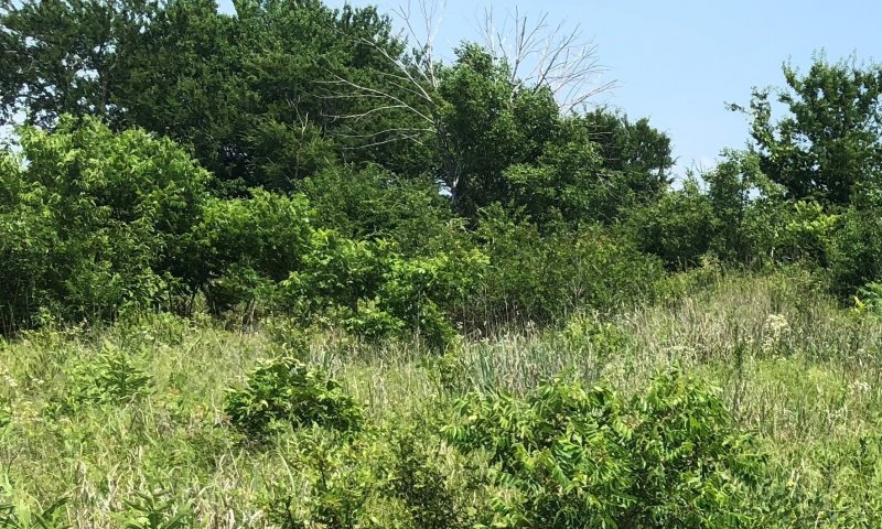
Figure 11. Rayford soils approaching state 4. Murray County, OK
This state describes the invaded, woody dominated plant community of the Clay Upland site. The ecological processes are dominated by woody species including mesquite, honey locust, elm, and juniper species. Some herbaceous plants persist under the woody canopy or in interspaces. Usually, shade tolerant species like Texas wintergrass are prominent herbaceous components in this community. There may also be an increase in prickly pear in this state.
Dominant plant species
-
juniper (Juniperus), tree
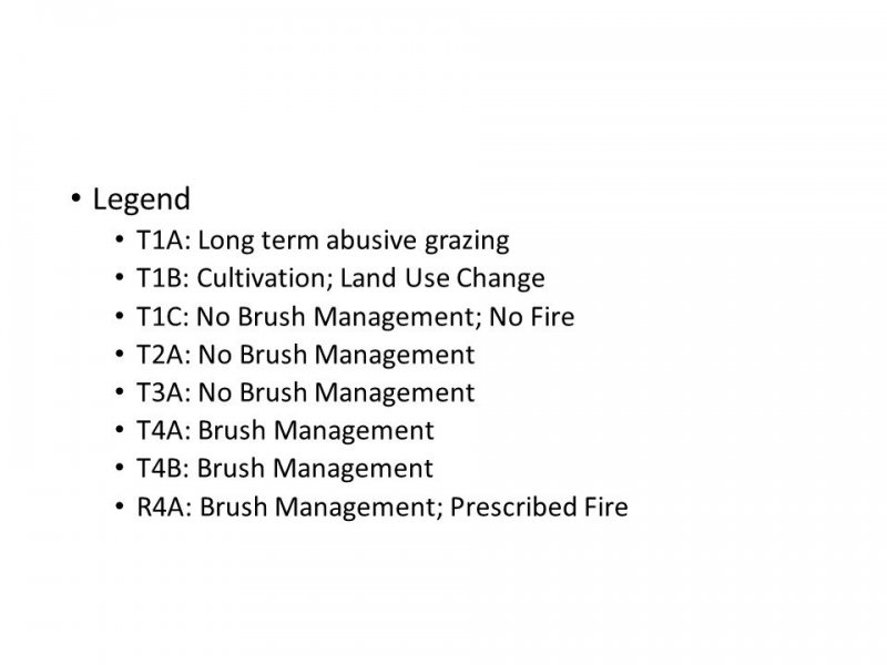
Transition T1A
State 1 to 2
With years of abusive grazing, more palatable grasses and forbs will decline and lead to a shift towards a sodded shortgrass and annual dominated state.
Transition T1B
State 1 to 3
Most of these sites were cultivated for crop production during the settlement of the area. Many of them have been planted to monocultures of introduced forage grasses in recent years. When these sites are cultivated, the soil properties are significantly altered from the reference state. Soil structure, hydrology and biology have been impacted and the site is transitioned to the Converted state.
Transition T1C
State 1 to 4


Without fire or other brush management, woody species will increase and dominate the site.
Transition T2A
State 2 to 4
These sites are prone to invasion by juniper, mesquite and honey locust. Without brush management, brush invasion may increase to the point where the site transitions to the Invaded Woodland state. At this point it will take significant inputs to remove woody species and restore the grass dominated pasture.
Transition T3A
State 3 to 4
These sites are prone to invasion by juniper, mesquite and honey locust. Without brush management, brush invasion may increase to the point where the site transitions to the Invaded Woodland state. At this point it will take significant inputs to remove woody species and restore the grass dominated pasture.
Restoration pathway R4A
State 4 to 1


At this point it will take significant inputs to remove woody species and restore the grass dominated pasture. However, it may be achieved through brush management, prescribed fire, and a prescribed grazing plan which allows ample rest for the re-establishment of grasses.
Transition T4B
State 4 to 2
At this point it will take significant inputs to remove woody species and restore the grass dominated pasture. However, it may be achieved through brush management and a prescribed grazing plan which allows ample rest for the re-establishment of grasses.
Transition T4A
State 4 to 3
At this point it will take significant inputs to remove woody species and restore the grass dominated pasture. However, it may be achieved through brush management and a prescribed grazing plan which allows ample rest for the re-establishment of grasses.
Additional community tables
Interpretations
Animal community
Domestic livestock and white-tail deer are the dominant grazers and browsers of the site. Various songbirds and small mammals may also find use of these areas. As the site changes towards the woody dominated community, the quality of the habitat may improve for some species and decline for others. Management must be applied to maintain a vegetative state in optimum habitat quality for the desired animal species.
Hydrological functions
These sites occur on upland and shed water to adjacent sites lower on the landscape. The presence of deep rooted tallgrasses can help facilitate percolation of water into the soil profile.
Recreational uses
NA
Wood products
NA
Other products
NA
Other information
NA
Supporting information
Inventory data references
Soil Survey Manuscripts Murray, Carter, Johnston counties in Oklahoma.
Range Site Descriptions, Oklahoma NRCS
Draft ESDs Oklahoma NRCS
Type locality
| Location 1: Murray County, OK | |
|---|---|
| Township/Range/Section | T1S R3E S9 |
| General legal description | 9-T1S-R3E CNRA |
References
-
. 2021 (Date accessed). USDA PLANTS Database. http://plants.usda.gov.
-
Frost, C.C. 1998. Presettlement Fire Frequency Regimes of the United States: A First Approximation. Plant Conservation Program. North Carolina Department of Agriculture and Consumer Services, Raleigh, NC.
Other references
These site descriptions were developed as part a Provisional ESD project using historic soil survey manuscripts, available range site descriptions, and low intensity field traverse sampling.
Contributors
Colin Walden, Soil Survey Region 9
Approval
Bryan Christensen, 9/21/2023
Acknowledgments
Site Development and Testing Plan:
Future work, as described in a Project Plan, to validate the information in this Provisional Ecological Site Description is needed. This will include field activities to collect low, medium, and high-intensity sampling, soil correlations, and analysis of that data. Annual field reviews should be done by soil scientists and vegetation specialists. A final field review, peer review, and quality control and quality assurance reviews of the ESD will be needed to produce the final document. Annual reviews of the Project Plan are to be conducted by the Ecological Site Technical Team.
Rangeland health reference sheet
Interpreting Indicators of Rangeland Health is a qualitative assessment protocol used to determine ecosystem condition based on benchmark characteristics described in the Reference Sheet. A suite of 17 (or more) indicators are typically considered in an assessment. The ecological site(s) representative of an assessment location must be known prior to applying the protocol and must be verified based on soils and climate. Current plant community cannot be used to identify the ecological site.
| Author(s)/participant(s) | |
|---|---|
| Contact for lead author | |
| Date | 09/22/2023 |
| Approved by | Bryan Christensen |
| Approval date | |
| Composition (Indicators 10 and 12) based on | Annual Production |
Indicators
-
Number and extent of rills:
-
Presence of water flow patterns:
-
Number and height of erosional pedestals or terracettes:
-
Bare ground from Ecological Site Description or other studies (rock, litter, lichen, moss, plant canopy are not bare ground):
-
Number of gullies and erosion associated with gullies:
-
Extent of wind scoured, blowouts and/or depositional areas:
-
Amount of litter movement (describe size and distance expected to travel):
-
Soil surface (top few mm) resistance to erosion (stability values are averages - most sites will show a range of values):
-
Soil surface structure and SOM content (include type of structure and A-horizon color and thickness):
-
Effect of community phase composition (relative proportion of different functional groups) and spatial distribution on infiltration and runoff:
-
Presence and thickness of compaction layer (usually none; describe soil profile features which may be mistaken for compaction on this site):
-
Functional/Structural Groups (list in order of descending dominance by above-ground annual-production or live foliar cover using symbols: >>, >, = to indicate much greater than, greater than, and equal to):
Dominant:
Sub-dominant:
Other:
Additional:
-
Amount of plant mortality and decadence (include which functional groups are expected to show mortality or decadence):
-
Average percent litter cover (%) and depth ( in):
-
Expected annual annual-production (this is TOTAL above-ground annual-production, not just forage annual-production):
-
Potential invasive (including noxious) species (native and non-native). List species which BOTH characterize degraded states and have the potential to become a dominant or co-dominant species on the ecological site if their future establishment and growth is not actively controlled by management interventions. Species that become dominant for only one to several years (e.g., short-term response to drought or wildfire) are not invasive plants. Note that unlike other indicators, we are describing what is NOT expected in the reference state for the ecological site:
-
Perennial plant reproductive capability:
Print Options
Sections
Font
Other
The Ecosystem Dynamics Interpretive Tool is an information system framework developed by the USDA-ARS Jornada Experimental Range, USDA Natural Resources Conservation Service, and New Mexico State University.
Click on box and path labels to scroll to the respective text.
