Natural Resources
Conservation Service
Ecological site F094CY032MI
Cool Acidic Sandy Depression
Last updated: 9/11/2024
Accessed: 02/07/2026
General information
Provisional. A provisional ecological site description has undergone quality control and quality assurance review. It contains a working state and transition model and enough information to identify the ecological site.

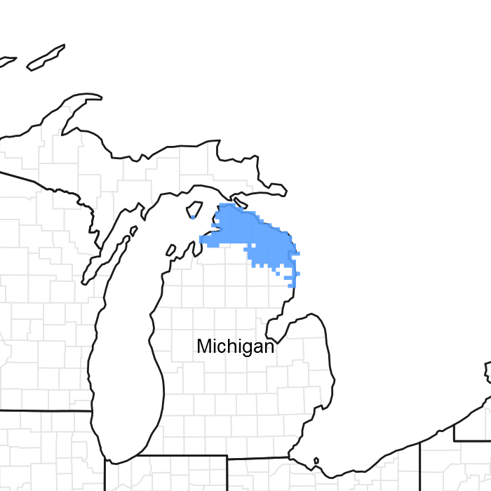
Figure 1. Mapped extent
Areas shown in blue indicate the maximum mapped extent of this ecological site. Other ecological sites likely occur within the highlighted areas. It is also possible for this ecological site to occur outside of highlighted areas if detailed soil survey has not been completed or recently updated.
MLRA notes
Major Land Resource Area (MLRA): 094C–Northern Michigan Limestone Lake Plains
This area is dominated by lake plains, some of which are till-floored plains. Drumlins, moraines, and outwash plains occur throughout the area. The terrain includes flat outwash and lake plains and steep slopes in areas of moraines. Elevation ranges from 177 to 300 m (580 to 985 ft). Local topographic relief averages 7 m and ranges up to 79 m (25 to 260 ft). The Cheboygan, Ocqueoc, and Thunder Bay Rivers are the major streams in the area. This area is covered with thin to thick glacial deposits. Bedrock is generally at shallow depths and is evident throughout the area. It consists of Devonian limestone and dolomite with interbedded shale, chert, and anhydrite stringers. Karst features are very common in the area.
About two-thirds of this MLRA is in small, privately owned holdings, and the other third consists of State forestland. The forests are used mainly for timber production and recreation. Dairy and beef operations are very important enterprises in the area. Forage and feed grain crops for dairy cattle and other livestock are the principal crops. Wheat, oats, corn, potatoes, and hay also are grown. Wilderness State Park Natural Area, Negwegon State Park, Atlanta State Forest, and Beaver Island State Wildlife Research Area are among the more notable conservation lands in the area.
Summary of existing land use:
Upland Forest (40%)
Hardwood (24%)
Conifer (14%)
Swamps and Marshes (32%)
Developed (10%)
Agricultural (8%)
Open Water (6%)
Classification relationships
According to the USFS (Bailey) system of ecoregions, the site is located mostly within 212Hj (Presque Isle Lake and Till Plains) and 212Hl (Valders Red Till and Sandy Lake Plain) subsections. According to the EPA (Omernik) system of ecoregions, the site is located in 50ab (Cheboygan Lake Plain) and eastern 50ac (Onaway Moraines) level IV ecoregions. This site roughly corresponds to PArVCo, in the Kotar system. This site corresponds to the Lowland, ecological land type phase, 62, in the USFS Ecological Land Type system.
Ecological site concept
The central concept of Cool Acidic Sandy Depression is lowlands with a seasonal high watertable 25 to 100 cm deep (moderately well drained or somewhat poorly drained) and a soil pH of the upper 50 cm less than 5.5, and a low base saturation, including Spodosols, Ultic subgroups, and dysic great groups and families. Site occurs on sandy drift (outwash, ice contact, or lake plains) where soil textures are sand or loamy sand (upper 50 cm >70% sand). Site is in lower elevation northern portions of the MLRA where boreal conifer species are more frequent associates. Vegetation trending towards mesophytic forest with an acidophilic species composition.
Associated sites
| F094CY031MI |
Cool Rich Sandy Drift |
|---|---|
| F094CY033MI |
Cool Wet Acidic Sandy Depression |
Similar sites
| F094AB020MI |
Acidic Sandy Depression |
|---|
Table 1. Dominant plant species
| Tree |
(1) Tsuga canadensis |
|---|---|
| Shrub |
Not specified |
| Herbaceous |
(1) Cornus canadensis |
Click on box and path labels to scroll to the respective text.