Natural Resources
Conservation Service
Ecological site F094DY007WI
Sand Barrens
Accessed: 02/22/2026
General information
Provisional. A provisional ecological site description has undergone quality control and quality assurance review. It contains a working state and transition model and enough information to identify the ecological site.

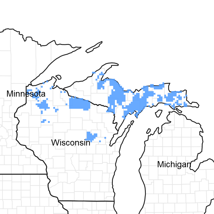
Figure 1. Mapped extent
Areas shown in blue indicate the maximum mapped extent of this ecological site. Other ecological sites likely occur within the highlighted areas. It is also possible for this ecological site to occur outside of highlighted areas if detailed soil survey has not been completed or recently updated.
MLRA notes
Major Land Resource Area (MLRA): 094D–Northern Highland Sandy Pitted Outwash
MLRA 94D, the Northern Highland Sandy Drift, comprises 1.346 million acres of outwash plains, sandy moraines, wetlands and numerous water bodies (large lakes, small ponds, large rivers, small streams and flowages of all sizes). Sand Barrens lie at driest end of the soil-landscape moisture gradient and they comprise about 50,000 acres in this MLRA.
Classification relationships
The Sand Barrens ecological site correlates to a PQE habitat type developed by Kotar et al (2002); this habitat types is named after Pinus strobus (white pine)-Quercus rubra (red oak)/Epigea repens (trailing arbutus). These species have a very high constancy value relative to this site, i.e. they are present on a higher percentage of these sites than other species. This ecological site has a very dry moisture regime and is poor in nutrients. The Sand Barrens ecological site has analogs in every ecological classification system. Probably because very dry sites, like wetlands, have a unique plant community and a long list of management concerns: drought-prone soils, fire-prone vegetation, rare species, and generally low productivity all present a host of issues to be resolved.
Ecological site concept
ATTENTION: This ecological site meets the NESH 2014 requirements for PROVISIONAL. A provisional ecological site is established after broad ecological site concepts are identified and an initial state-and-transition model is drafted. Following quality control and quality assurance reviews of the ecological site concepts, an identification number and name for the provisional ecological site are entered into ESIS. A provisional ecological site may include literature reviews, land use history information, some soils data, legacy data, ocular estimates for canopy and/or species composition by weight, and even some line-point intercept information. A provisional ecological site does not meet the NESH 2014 standards for an Approved ESD, but does provide the conceptual framework of soil-site correlation for the development of the ESD. For more information about this ecological site, please contact your local NRCS office.
Sand Barrens ecological sites are driest (most xeric) of the ecological sites in this MLRA. As such, they have been very prone to disturbance, now and in the past. In European pre-settlement times, low-level fires were common and kept many areas open and the fuel load low. Under the current conditions of effective and mostly necessary fire suppression many areas have an increasing fuel load, and coincidentally became dominated by fewer species. Jack pine and northern pin oak (which is often hybridized with black oak in this region) were once the dominant trees, with openings between that resembled prairie or savanna. At present the savanna-like nature of the vegetation has been drastically altered to a patchwork of thick, stunted, jack pine stands, marginally productive red pine plantations, and weedy open areas dominated by bracken fern or exotic invasive species such as spotted knapweed (Centaurea stoebe)and Canada bluegrass (Poa compressa). Small patches of the pyrophilic savanna vegetation still exist on the driest, most nutrient-poor sites. Otherwise, on slightly richer sites, woody plants overtop and eliminate the prairie plants, all because of the absence of frequent low-intensity fires.
Associated sites
| F094DY006WI |
Steep Sandy Ridges Steep Sandy Ridges occur frequently on sand plains that are predominantly either Sand Barrens or Sandy Uplands. The steeper areas are more affected by aspect than the lower slope areas. |
|---|
Table 1. Dominant plant species
| Tree |
(1) Pinus banksiana |
|---|---|
| Shrub |
(1) Vaccinium angustifolium |
| Herbaceous |
(1) Gaultheria procumbens |
Click on box and path labels to scroll to the respective text.