Natural Resources
Conservation Service
Ecological site F094DY009WI
Wet Sandy Drainageways
Accessed: 02/11/2026
General information
Provisional. A provisional ecological site description has undergone quality control and quality assurance review. It contains a working state and transition model and enough information to identify the ecological site.

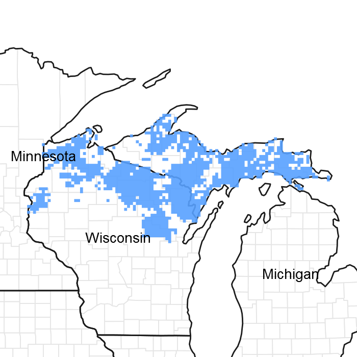
Figure 1. Mapped extent
Areas shown in blue indicate the maximum mapped extent of this ecological site. Other ecological sites likely occur within the highlighted areas. It is also possible for this ecological site to occur outside of highlighted areas if detailed soil survey has not been completed or recently updated.
MLRA notes
Major Land Resource Area (MLRA): 094D–Northern Highland Sandy Pitted Outwash
MLRA 94D, the Northern Highland Sandy Drift, comprises 1.346 million acres of outwash plains, sandy moraines, wetlands and numerous water bodies (large lakes, small ponds, large rivers, small streams and flowages of all sizes). The Wet Sandy Drainageways ecological site comprises about 30,000 acres in MLRA 94D.
Classification relationships
The Wet Sandy Drainageways ecological sites correlate to the ArAbVC habitat type developed by Kotar et al (2002); this habitat type is named after Acer rubrum (red maple)-Abies balsamea (balsam fir)/Vaccinium angustifolium (low-bush blueberry)-Coptis trifolia (goldthread). These species have very high constancy value relative to this site, i.e. they are present on a higher percentage of these sites than other species. This ecological site has a wet-mesic moisture regime and is poor in nutrients.
Ecological site concept
ATTENTION: This ecological site meets the NESH 2014 requirements for PROVISIONAL. A provisional ecological site is established after broad ecological site concepts are identified and an initial state-and-transition model is drafted. Following quality control and quality assurance reviews of the ecological site concepts, an identification number and name for the provisional ecological site are entered into ESIS. A provisional ecological site may include literature reviews, land use history information, some soils data, legacy data, ocular estimates for canopy and/or species composition by weight, and even some line-point intercept information. A provisional ecological site does not meet the NESH 2014 standards for an Approved ESD, but does provide the conceptual framework of soil-site correlation for the development of the ESD. For more information about this ecological site, please contact your local NRCS office.
The Wet Sandy Drainageway ecological sites are of intermediate wetness. The soils are somewhat poorly drained, but they are not hydric. The plant communities have some wetland species, but no obligate wetland species. In other words, like the slightly drier Sandy Terraces and Plains ecological site, this site occupies the zone between wetlands and uplands where its characteristics are affected by a seasonal high water table that drains rapidly and frequent groundwater flowthrough events. The site is more species rich and more productive than the other sandy ecological site because of this wet-mesic moisture regime.
Associated sites
| F094DY010WI |
Wet Sandy Depressions Wet Sandy Depressions are common within larger Wet Sandy Drainageways. |
|---|
Table 1. Dominant plant species
| Tree |
(1) Acer rubrum |
|---|---|
| Shrub |
(1) Corylus cornuta |
| Herbaceous |
(1) Clintonia borealis |
Click on box and path labels to scroll to the respective text.
