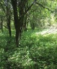
Image courtesy of UWSP taken on 05/30/2020 in Jefferson County, WI.
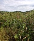
Image courtesy of UWSP taken on 08/08/2020 in Dane County, WI.
Description
Because of the dynamic nature of hydrological events affecting this Ecological Site, many different plant communities can be found at any given time. Three distinct community phases represent the Reference state: 1) a forested phase with seasonal, brief ponding, community phase, 2) shrub phase with extended ponding community phase, and 3) open phase ponded community phase.
Submodel
1.1. Forested Phase/Infrequently Ponded
1.2. Shrub Phase/Extended Ponding
1.3. Open Phase/Ponded
Model keys
Briefcase
Add ecological sites and Major Land Resource Areas to your briefcase by clicking on the briefcase () icon wherever it occurs. Drag and drop items to reorder. Cookies are used to store briefcase items between browsing sessions. Because of this, the number of items that can be added to your briefcase is limited, and briefcase items added on one device and browser cannot be accessed from another device or browser. Users who do not wish to place cookies on their devices should not use the briefcase tool. Briefcase cookies serve no other purpose than described here and are deleted whenever browsing history is cleared.
The Ecosystem Dynamics Interpretive Tool is an information system framework developed by the USDA-ARS Jornada Experimental Range, USDA Natural Resources Conservation Service, and New Mexico State University.