Natural Resources
Conservation Service
Ecological site R097XB047IL
Chicago Wet Clayey Flats
Last updated: 1/16/2024
Accessed: 11/23/2024
General information
Provisional. A provisional ecological site description has undergone quality control and quality assurance review. It contains a working state and transition model and enough information to identify the ecological site.

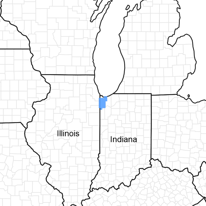
Figure 1. Mapped extent
Areas shown in blue indicate the maximum mapped extent of this ecological site. Other ecological sites likely occur within the highlighted areas. It is also possible for this ecological site to occur outside of highlighted areas if detailed soil survey has not been completed or recently updated.
MLRA notes
Major Land Resource Area (MLRA): 097X–Southwestern Michigan Fruit and Vegetable Crop Belt
Physiography consists of sandy lake plains and dunes along the western side adjacent to Lake Michigan, and moderately sloping fine-loamy moraine from the Lake Michigan lobe of the Wisconsin Ice Sheet.
Vegetation is mostly mesophytic forests of central and northern hardwood and conifer species with prairie and oak savanna to the south. Compared to inland locations, cold sensitive hardwood species extend further north due to milder winters, and conifers extend further south due to cooler summers, heavier snowfall, and sandier soils. Lake effect snow and delayed spring warm up dampen the fire frequency relative to similar inland sites, except along the south side of Lake Michigan. The northern extent is defined by a major floristic boundary where several central hardwoods species drop out. The southern boundary is defined by fine-loamy moraines with predominantly prairie vegetation.
The ecological site inference area for MLRA 97 is subdivided along a floristic/climatic break roughly from New Buffalo, Michigan to Portage, Indiana. This corresponds to the heaviest lake effect snow belt (>160 cm) south and east of this line and is associated lower historic fire frequencies. The snow belt portion “A”, has more frequent conifer and beech, while the less snowy portion “B” has more prairie and savanna elements. Although differing in precise boundary location, both USFS and EPA ecoregions support a climatic/floristic break at the next higher rank in their respective hierarchies.
Classification relationships
Among the USFS ecoregional framework (Cleland et al., 2007), most of MLRA 97 is represented by the Humid Temperate Domain (200), Hot Continental Division (220), Midwest Broadleaf Forest Province (222), South Central Great Lakes Section (222J), subsections 222Ja and 222Jb. MLRA 97 was recently extended northward to be more consistent with the limits of the USFS ecoregions subsections 222Ja and 222Jb, because it is more consistent with vegetation patterns and species distributions. A former portion of MLRA 97 that extended westward from the southern end of Lake Michigan (including most of the city of Chicago) was recently removed from the MLRA due to its predominantly non-sandy deposits and reduced lake effect climate, and would have overlapped USFS ecoregion 222K.
Among the EPA ecoregional framework (Omernik and Griffith, 2014), most of MLRA 97 falls within Eastern Temperate Forests (Level I: 8), Mixed Wood Plains (Level II: 8.1), Southern Michigan/Northern Indiana Drift Plains (Level III: 56), and Level IV: 56d and 56f. Ecoregion 56f continues north beyond MLRA 97. Former portions of MLRA 97 that encompassed the city of Chicago included Level III ecoregion 54, Central Corn Belt Plains, before the last revision of MRLA boundaries.
Ecological site concept
The central concept of the Wet Clayey Flats is fine-loamy to clayey wave worked till or lacustrine deposits with a horizon of very low saturated hydraulic conductivity within 100 cm of the surface. Site is generally found in poorly to very poorly drained flats, and is frequently episaturated with a perched water table. Due to very low saturated conductivity, depressional locations are subject to ponding from local rainfall events, but with little groundwater input. Due to the high fire frequency of the surrounding landscape, reference vegetation is wet prairie rather than swamp.
Associated sites
| R097XB046IL |
Chicago Moist Clayey Flats |
|---|
Similar sites
| F097XA023MI |
Wet Loamy Depression |
|---|
Table 1. Dominant plant species
| Tree |
Not specified |
|---|---|
| Shrub |
Not specified |
| Herbaceous |
(1) Spartina pectinata |
Click on box and path labels to scroll to the respective text.