Natural Resources
Conservation Service
Ecological site R102AY001SD
Shallow Marsh
Last updated: 5/05/2025
Accessed: 04/11/2026
General information
Provisional. A provisional ecological site description has undergone quality control and quality assurance review. It contains a working state and transition model and enough information to identify the ecological site.
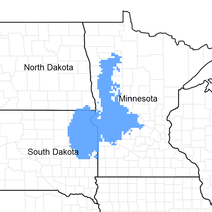
Figure 1. Mapped extent
Areas shown in blue indicate the maximum mapped extent of this ecological site. Other ecological sites likely occur within the highlighted areas. It is also possible for this ecological site to occur outside of highlighted areas if detailed soil survey has not been completed or recently updated.
MLRA notes
Major Land Resource Area (MLRA): 102A–Rolling Till Prairie
The Rolling Till Prairie (102A) is located within the Central Feed Grains and Livestock Land Resource Region. It spans 3 states (Minnesota 58 percent, South Dakota 42 percent, and small part in North Dakota), encompassing over 16,000 square miles (Figure 1). The elevation ranges from approximately over 2,000 feet above sea level (ASL) on the Prairie Coteau in Northeastern South Dakota to about 1,000 feet ASL on lowlands. The dominate landforms in this area are stagnation moraines, end moraines, glacial outwash plains, terraces, and flood plains. The area is dominated by till covered moraines. The stagnation moraines are gently undulating to steep and have many depressions and poorly defined drainages. Small outwash areas are adjacent to the watercourses. The Cretaceous Pierre Shale underlies the till in the most of the area. Precambrian rocks also occur at depth. Granite is quarried near Milbank, South Dakota and outcrops of Sioux Quartzite are common. (USDA-NRCS 2006).
The dominant soil order in this MLRA is Mollisols. The soils in the area dominantly have a frigid soil temperature regime, an aquic or udic soil moisture regime, and mixed mineralogy. They generally are very deep, well drained to very poorly drained. This area supports true prairie vegetation characterized by big bluestem (Andropogon gerardii), little bluestem (Schizachyrium scoparium), porcupinegrass (Hesperostipa spartea), and green needlegrass (Nassella viridula). Prairie cordgrass (Spartina pectinata) commonly grows in wet areas. (USDA-NRCS 2006).
Classification relationships
Major Land Resource Area (MLRA): Rolling Till Prairie (102A) (USDA-NRCS 2006)
USFS Subregions: North Central Glaciated Plains Section (251B); Upper Minnesota River-Des Moines Lobe Subsection (251Ba); Outer Coteau des Prairies Subsection (251Bb); Northwest Iowa Plains Subsection (251Bd); Minnesota and Northeast Iowa Morainal-Oak Savannah Section (222M); Alexandria Moraine-Hardwood Hills Subsection (222Ma) (Cleland et al. 2007).
US EPA Level IV Ecoregion: Tewaukon/Big Stone Stagnation Moraine (46e), Prairie Coteau (46k), Prairie Coteau Escarpment (46l), Big Sioux Basin (46m), Minnesota River Prairie (46o), Des Moines Lobe (47b) , Lake Agassiz Plains (48d), Alexandria Moraines and Detroit Lakes Outwash Plain (51j) (USEPA 2013)
Ecological site concept
The Shallow Marsh ecological site typically occurs in a basin or closed depression, and receives water directly from precipitation, surface overland flow, and groundwater discharge. Soils are formed in local alluvium and are very poorly drained, which have a water table within 1 foot of the soil surface. Permeability is very slow due to the clayey subsoil and the site will pond water until early summer in most years. Ponded water conditions and very slow permeability strongly influences the soil-water-plant relationship. Vegetation in the Reference State is typically dominated by cool-season grass and grass-like species including Whitetop, slough sedge, woolly sedge, American mannagrass, prairie cordgrass, and spikerush. Forb species may include smartweeds, western dock, and white panicle aster. Nonnative species such as quackgrass, creeping meadow foxtail, and Kentucky bluegrass may invade the site due to change in disturbance regime.
Associated sites
| R102AY004SD |
Wet Meadow These sites occur in a basin or closed depression. Soils are poorly drained and the site ponds water for 4 to 8 weeks in the spring of the year or after a heavy rain. The central concept soil series is Tonka, but other series are included. |
|---|---|
| R102AY020SD |
Loamy Overflow These sites occur in upland swales. Soils are moderately well drained which have water flow into and over/through the site. The central concept soil series is Aastad, Svea, and Waubay, but other series are included. |
| R102AY002SD |
Linear Meadow These sites occur in drainageways. Soils are poorly and very poorly drained which have a water table within 0 to 2 feet of the soil surface that persists longer than the wettest part of the growing season typically until the month of August. The central concept soil series are Vallers and Colvin, but other series are included. |
| R102AY003SD |
Subirrigated These sites occur in drainageways. Soils are somewhat poorly drained which have a water table within 2 to 5 feet of the soil surface that persists longer than the wettest part of the growing season typically until the month of August. The central concept soil series is Badger, but other series are included. |
Similar sites
| R102AY004SD |
Wet Meadow Wet Meadow is similar in landscape position, but the site ponds water only for 4 to 8 weeks in the spring of the year or after a heavy rain. A Wet Meadow site will have more prairie cordgrass and lower production than a Shallow Marsh. |
|---|
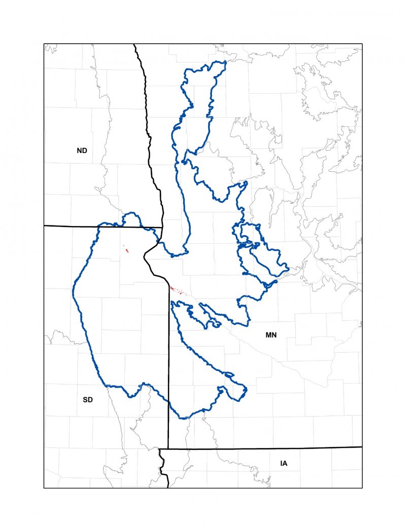
Figure 2.
Table 1. Dominant plant species
| Tree |
Not specified |
|---|---|
| Shrub |
Not specified |
| Herbaceous |
(1) Scolochloa festucacea |
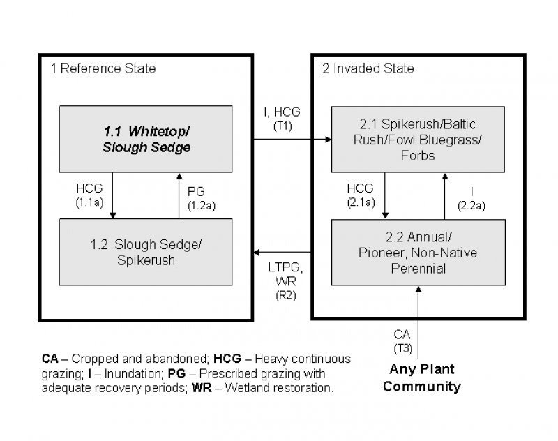
Click on box and path labels to scroll to the respective text.
| T1A | - | Heavy continuous grazing, inundation, no fire |
|---|---|---|
| T1B | - | Tillage, artificial drainage (surface and subsurface) |
| R2 | - | Long term prescribed grazing, wetland restoration |
| T2 | - | Tillage, artificial drainage (surface and subsurface) |
| T3 | - | Abandonment of cropping |
State 1 submodel, plant communities
| 1.1A | - | Heavy continuous grazing |
|---|---|---|
| 1.2 | - | Prescribed grazing with recovery periods |
State 2 submodel, plant communities
| 2.1 | - | Heavy continuous grazing, below normal precipitation period, no fire |
|---|---|---|
| 2.2 | - | Inundation |