Limestone Colluvium Bluff Prairie
Scenario model
Current ecosystem state
Select a state
Management practices/drivers
Select a transition or restoration pathway
- Transition 1A More details
- Transition 1A More details
- Transition 1B More details
- Transition 1B More details
- Restoration pathway 2A More details
- Restoration pathway 2A More details
- Transition 2A More details
- Transition 2A More details
- Transition 2B More details
- Transition 2B More details
- Restoration pathway 3A More details
- Restoration pathway 3A More details
- Transition 3B More details
- Restoration pathway 4A More details
- Restoration pathway 4A More details
-
No transition or restoration pathway between the selected states has been described
Target ecosystem state
Select a state
State 1
Reference State


Description
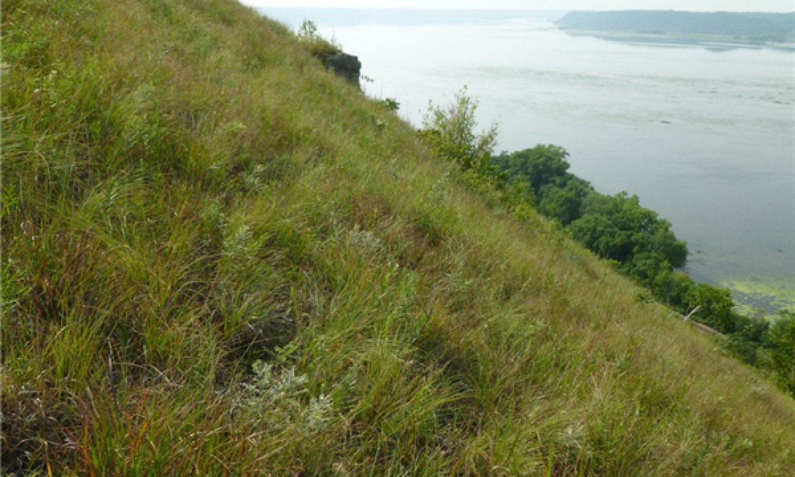
DCBP Reference States can be found in scattered locations throughout the MLRA 105, particularly in Wisconsin and Minnesota. Prior to European settlement, over 160,000 acres of the Reference State once existed, mostly in Community Phase 1.1 (Tables 6 through 9). River valleys trending east-west, with south-facing valley sides had bluff prairies on almost all suitable physical settings (Figure 6; Scottston and Atherton 2013). During this period, drought-driven fires were unimpeded, often set by indigenous peoples. As many as five fires per decade burned large, landscape scale areas (Jones and Bowles 2013). Evidence for what this phase looked like comes from realistic landscape painters, such as one by Henry Lewis in 1947 (Figure 4). Other artists, like George F. Fuller (1853), Edwin Whitefield (1858) and Alfred Sederberg (1867) depicted similar landscapes of the Mississippi River valley that included reference to bluff prairies (Coen 1976). There are also historical accounts of bluff prairies. For example, in 1781, Jonathan Carver described a prairie on a steep hillside along the lower Wisconsin River: “For miles nothing was to be seen but lesser mountains, which appeared at a distance like haycocks, they being free from trees…and only a few groves of hickory and stunted oaks covered some of the vallies” (Curtis 1959).
Reference states of DCBP on a given site can range in size from large, open prairie covering entire landforms, to small openings surrounded by forest, limited to the most exposed, steepest, and convex areas. Breaks in the slope, either from changes in the underlying bedrock, bedrock outcrops, or drainageways, may have a higher concentration of shrub and tree species, but do not detract from overall prairie condition. Periodic disturbances from fire maintained the dominance of drought and fire adapted native grasses and forbs by limiting the growth and dominance of trees and shrubs, especially eastern redcedar. Disturbance-free periods initially favor grass dominance and eventually allow encroachment shrubs, then trees. Two community phases are recognized in this state. Shifts between these phases are based primarily on fire frequency, and secondarily on grazing. With decreasing fire frequency, a shift from Community Phase 1.1 to 1.2 will occur, and exhibit an increase in shrub densities and overall decrease in species diversity, especially the loss of annuals and species of shorter stature (Kraszenski and Waller 2008).
Mesic tall grass prairies, which occur on soils with higher available water capacity, have been reported to develop into close canopy forest in as little as 35 years without fire (Hoch and Briggs 1999). In comparison, the persistence of bluff prairies in the absence of fire would likely be longer. The transition to State 2 (Eastern Redcedar/Prairie) versus State 3 (Scrub Deciduous Tree and Shrub/Prairie) remains a question. It at least partially depends on what plant communities are surrounding the site. Aspect may also be a factor. Bluff landforms that have a larger proportion of south or southwest aspects compared to west to west-southwest, and/or south-southeast may be more likely to transition to State 2. Soil type may be another factor. Sites that transition to State 2 may have lower available water capacity soils than State 3. These higher available water capacity soils could result from a thin loess cap. Further study is needed on this topic.
Submodel
State 2
Eastern Redcedar/Prairie State


Description
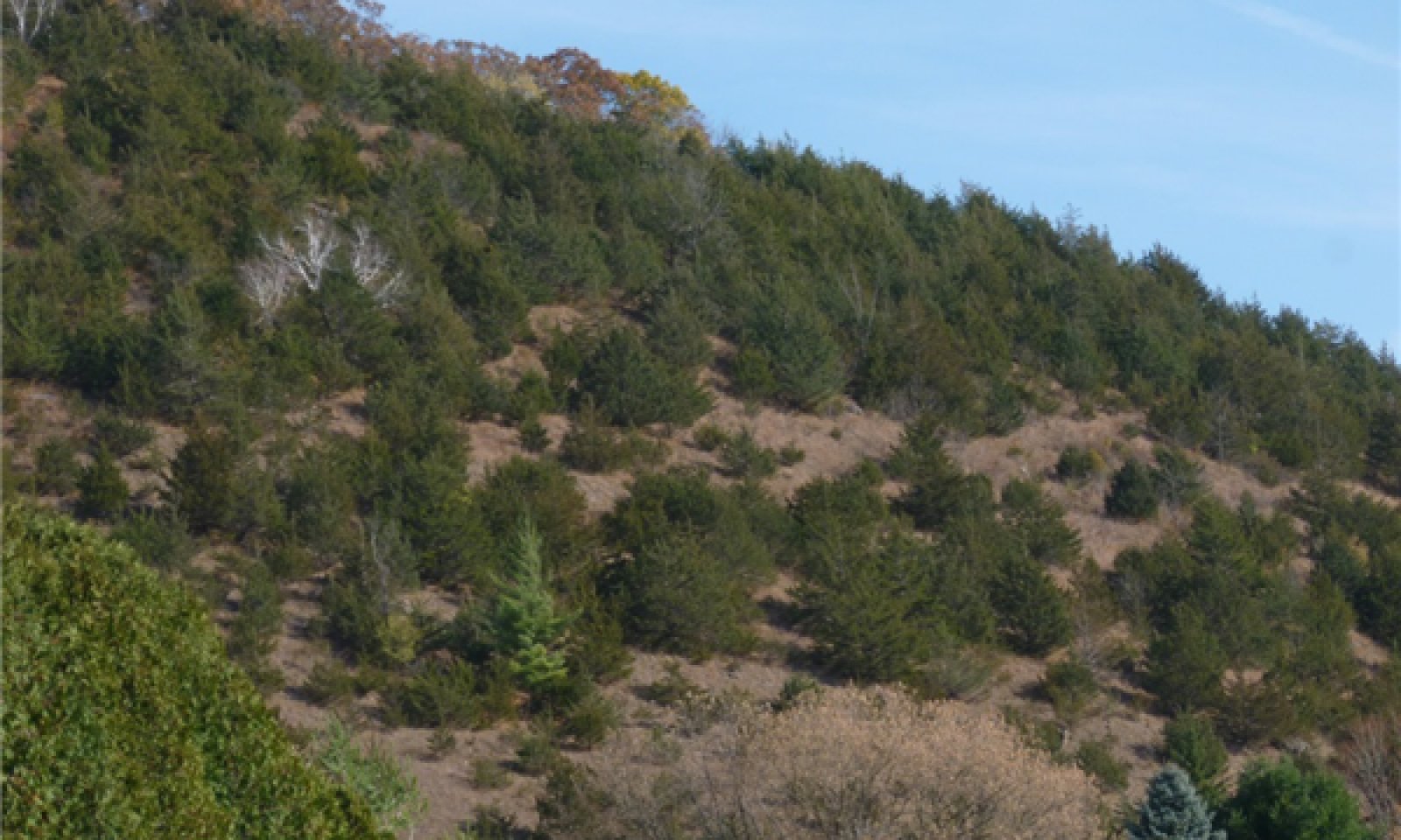
This state is dominated by eastern redcedar, which can be relatively even-aged, but there often are a few scattered older trees, especially near cliffs and ledges, or on very steep slope breaks. Eastern redcedar is a fire sensitive species, especially in their early growth stages. Their presence is an indication that fire has been absent for a prolonged period ( >20 years). Determining the age of dominant even-aged trees could give an idea of when fire was excluded. Historically, eastern redcedar is thought to colonize from cliff habitat during periods of fire exclusion (Jones and Bowles 2013). Other shrubs common to bluff prairies and scattered deciduous trees are also present at an increased density. Densities can range from 40 percent to nearly 100 percent. Interconnected patches of prairie are common when densities closer to 40 percent. However, the decline in diversity of prairie species (in particular the loss of annuals and those of shorter stature) may have already taken place (Kraszewski and Waller 2008). When densities reach nearly 100 percent, a few prairie species persist with diminutive stature, and it is likely that the soil contains a reservoir of prairie species in the seed bank.
Submodel
State 3
Scrub Deciduous Tree and Shrub/Prairie State


Description
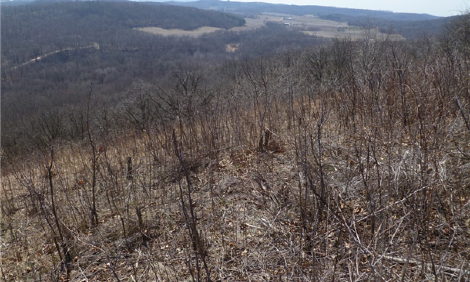
This state is dominated by native deciduous shrubs and small, immature trees, mixed with a small amount of eastern redcedar. This gradual transition results from prolonged periods of fire suppression, generally over 20 years. Deciduous shrub species that are normally found on this ecological site increase in density and height. Pioneer deciduous tree species invade from local sources. Prairie grasses and forbs still exist in the understory, but woodland forbs, grasses, and sedges may be appearing. Shrubs are tall and relatively dense. The most common species include: smooth sumac, gray dogwood, common ninebark, blackberry species, and common pricklyash. Sapling trees are scattered, and often of poor form. Common species may include: pin cherry (Prunus pensylvanica), bur oak, black oak, quaking aspen (Populus tremuloides), paper birch (Betula papyrifera), black cherry (Prunus serotina), green ash (Fraxinus pennsylvanica), and black walnut (Juglans nigra). Overall tree and shrub densities can range from 40 percent to nearly 100 percent. Interconnected patches of prairie are common when densities closer to 40 percent. However, a decline in the diversity of prairie species (in particular the loss of annuals and those of shorter stature) may have already taken place (Kraszewski and Waller 2008). When densities reach nearly 100 percent, a few prairie species persist with diminutive stature, and it is likely that the soil contains a reservoir of prairie species in the seed bank.
Submodel
Description
This state occurs when non-native, invasive shrubs become well established and produce novel, monotypic plant communities. Common buckthorn is the primary species of concern, but the non-native honeysuckles (Lonicera tartarica, L. morrowii) may be present as well. Sites near urban areas are more likely to be in this state. These species produce abundant seed and can rapidly spread by other by coppice regeneration, especially when they are cut without herbicide treatment. Birds are a primary dispersal agent of common buckthorn, often importing seed to DCBP sites that are in States 2 or 3. In some cases, when common buckthorn is present in the understory, but is not noticeable, attempts for restoration can release it, ultimately transitioning the site to State 4. In addition, thickets of common buckthorn can sometimes be found on the edges of sites in Community Phase 2.2. If eastern redcedar is removed there can be an onslaught of common buckthorn invading the site.
The initial stages of bluff prairie restoration could be impacted if sites are located near common buckthorn seed sources. When any bluff prairie restoration project is considered, an evaluation of potential common buckthorn seed sources should be completed.
Submodel
Mechanism
A gradual transition to a tree and shrub dominated condition (primarily eastern redcedar), resulting over 20 years of fire suppression. A lack of grazing by a diversity of grazers may also accelerate this transition.
Mechanism
A gradual transition to a tree and shrub dominated condition (primarily eastern redcedar), resulting over 20 years of fire suppression. A lack of grazing by a diversity of grazers may also accelerate this transition.
Mechanism
A gradual transition to a tree and shrub dominated condition (primarily deciduous trees and shrubs), resulting over 20 years of fire suppression. A lack of grazing by a diversity of grazers may also accelerate this transition.
Mechanism
A gradual transition to a tree and shrub dominated condition (primarily deciduous trees and shrubs), resulting over 20 years of fire suppression. A lack of grazing by a diversity of grazers may also accelerate this transition.
Mechanism
Complete removal of eastern redcedar and restoration of fire regime, leading to restoration of prairie flora characteristic of the Reference State.
Mechanism
Complete removal of eastern redcedar and restoration of fire regime, leading to restoration of prairie flora characteristic of the Reference State.
Transition 2A


Mechanism
Increased shade, providing potential for more shade tolerant deciduous trees and shrubs to become established. Sudden removal of eastern redcedar in State 2 can release seeds of shrubs brought in by birds, such as: smooth sumac, gray dogwood, blackberry species, and pricklyash.
Transition 2A


Mechanism
Increased shade, providing potential for more shade tolerant deciduous trees and shrubs to become established. Sudden removal of eastern redcedar in State 2 can release seeds of shrubs brought in by birds, such as: smooth sumac, gray dogwood, blackberry species, and pricklyash.
Mechanism
Common buckthorn becomes an established, co-dominant shrub, and is reproducing onsite.
Mechanism
Common buckthorn becomes an established, co-dominant shrub, and is reproducing onsite.
Mechanism
Nearly complete removal of deciduous trees and shrubs and restoration of fire regime, leading to restoration of prairie flora characteristic of the Reference State.
Mechanism
Nearly complete removal of deciduous trees and shrubs and restoration of fire regime, leading to restoration of prairie flora characteristic of the Reference State.
Mechanism
Common buckthorn becomes an established, co-dominant shrub, and is reproducing onsite.
Mechanism
Removal of common buckthorn, and other native and non-native shrubs and trees, with restoration of fire regime. This will likely require consecutive years of multiple types of management treatments.
Model keys
Briefcase
Add ecological sites and Major Land Resource Areas to your briefcase by clicking on the briefcase (![]() ) icon wherever it occurs. Drag and drop items to reorder. Cookies are used to store briefcase items between browsing sessions. Because of this, the number of items that can be added to your briefcase is limited, and briefcase items added on one device and browser cannot be accessed from another device or browser. Users who do not wish to place cookies on their devices should not use the briefcase tool. Briefcase cookies serve no other purpose than described here and are deleted whenever browsing history is cleared.
) icon wherever it occurs. Drag and drop items to reorder. Cookies are used to store briefcase items between browsing sessions. Because of this, the number of items that can be added to your briefcase is limited, and briefcase items added on one device and browser cannot be accessed from another device or browser. Users who do not wish to place cookies on their devices should not use the briefcase tool. Briefcase cookies serve no other purpose than described here and are deleted whenever browsing history is cleared.
Ecological sites
Major Land Resource Areas
The Ecosystem Dynamics Interpretive Tool is an information system framework developed by the USDA-ARS Jornada Experimental Range, USDA Natural Resources Conservation Service, and New Mexico State University.


