Natural Resources
Conservation Service
Ecological site R107XB012MO
Calcareous Loess Upland Prairie
Last updated: 5/21/2020
Accessed: 04/10/2026
General information
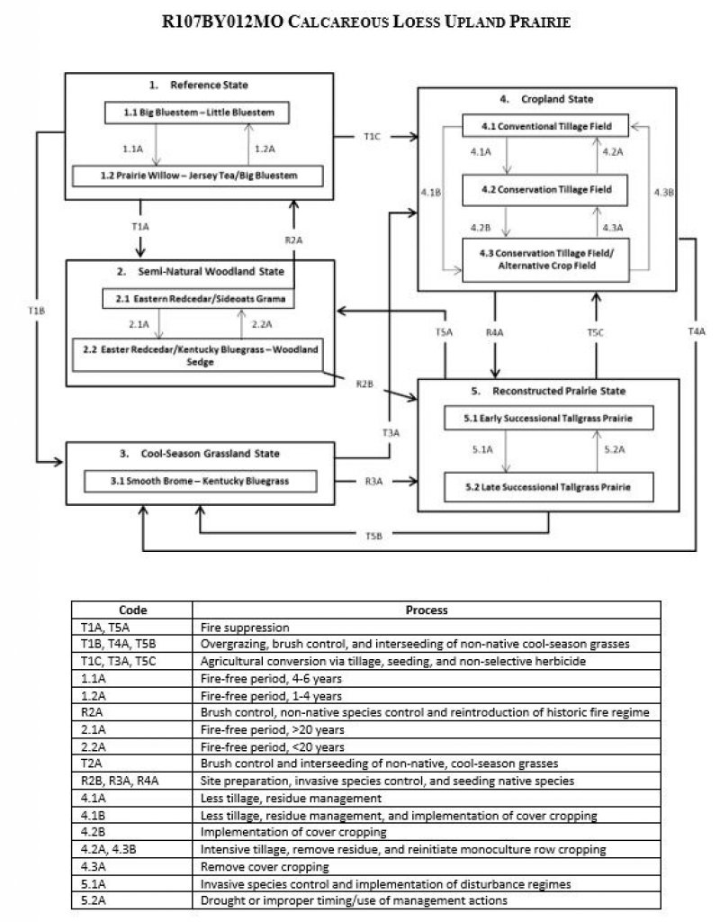
Provisional. A provisional ecological site description has undergone quality control and quality assurance review. It contains a working state and transition model and enough information to identify the ecological site.
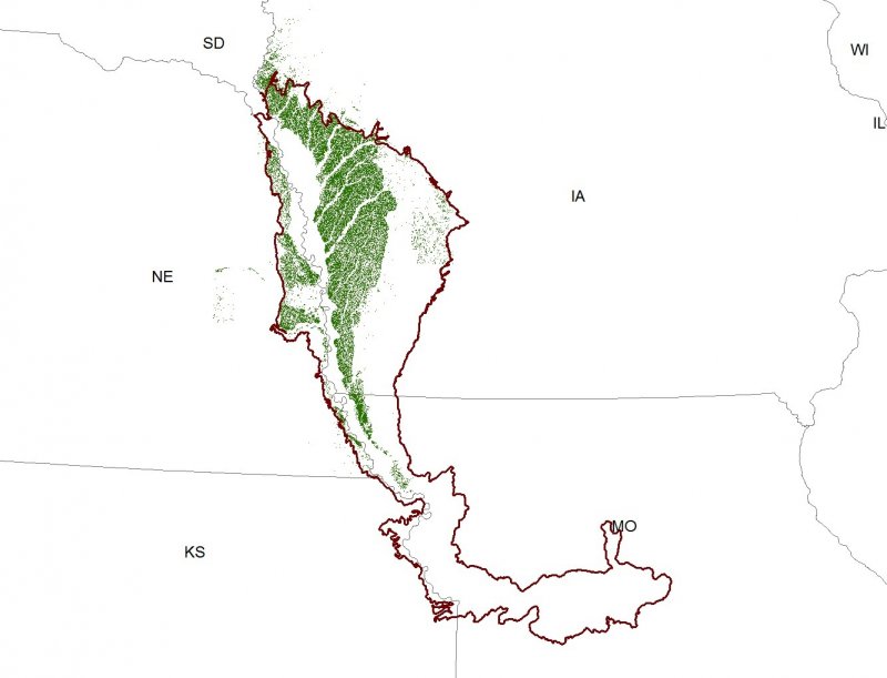
Figure 1. Mapped extent
Areas shown in blue indicate the maximum mapped extent of this ecological site. Other ecological sites likely occur within the highlighted areas. It is also possible for this ecological site to occur outside of highlighted areas if detailed soil survey has not been completed or recently updated.
MLRA notes
Major Land Resource Area (MLRA): 107X–Iowa and Missouri Deep Loess Hills
The Iowa and Missouri Deep Loess Hills (MLRA 107B) includes the Missouri Alluvial Plain, Loess Hills, Southern Iowa Drift Plain, and Central Dissected Till Plains landform regions (Prior 1991; Nigh and Schroeder 2002). It spans four states (Iowa, 53 percent; Missouri, 32 percent; Nebraska, 12 percent; and Kansas 3 percent), encompassing over 14,000 square miles (Figure 1). The elevation ranges from approximately 1565 feet above sea level (ASL) on the highest ridges to about 600 feet ASL along the Missouri River near Glasgow in central Missouri. Local relief varies from 10 to 20 feet in the major river floodplains, to 50 to 100 feet in the dissected uplands, and loess bluffs of 200 to 300 feet along the Missouri River. Loess deposits cover most of the area, with deposits reaching a thickness of 65 to 200 feet in the Loess Hills and grading to about 20 feet in the eastern extent of the region. Pre-Illinoian till, deposited more than 500,000 years ago, lies beneath the loess and has experienced extensive erosion and dissection. Pennsylvanian and Cretaceous bedrock, comprised of shale, mudstones, and sandstones, lie beneath the glacial material (USDA-NRCS 2006).
The vegetation in the MLRA has undergone drastic changes over time. Spruce forests dominated the landscape 30,000 to 21,500 years ago. As the last glacial maximum peaked 21,500 to 16,000 years ago, they were replaced with open tundras and parklands. The end of the Pleistocene Epoch saw a warming climate that initially prompted the return of spruce forests, but as the warming continued, spruce trees were replaced by deciduous trees (Baker et al. 1990). Not until approximately 9,000 years ago did the vegetation transition to prairies as climatic conditions continued to warm and subsequently dry. Between 4,000 and 3,000 years ago, oak savannas began intermingling within the prairie landscape. This prairie-oak savanna ecosystem formed the dominant landscapes until the arrival of European settlers (Baker et al. 1992).
Classification relationships
Major Land Resource Area (MLRA): Iowa and Missouri Deep Loess Hills (107B) (USDA-NRCS 2006)
USFS Subregions: Central Dissected Till Plains Section (251C), Loess Hills (251Cb) Subsection ; Nebraska Rolling Hills Section (251H), Pawnee City-Seneca Rolling Hill (251Hd) (Cleland et al. 2007)
U.S. EPA Level IV Ecoregion: Steeply Rolling Loess Prairies (47e), Nebraska/Kansas Loess Hills (47h), Western Loess Hills (47m) (USEPA 2013)
Biophysical Setting (LANDFIRE 2009): Central Tallgrass Prairie (4214210)
Ecological Systems (National Vegetation Classification System, Nature Serve 2015): Central Tallgrass Prairie (CES205.683)
Eilers and Roosa (1994): Loess Hills
Iowa Department of Natural Resources (INAI nd): Western Dry-Mesic Prairie
Missouri Natural Heritage Program (Nelson 2010): Dry Loess/Glacial Till Prairie
Nebraska Game and Parks Commission (Steinauer and Rolfsmeier 2003): Upland Tall-Grass Prairie
Plant Associations (National Vegetation Classification System, Nature Serve 2015): Andropogon gerardii – Sorghastrum nutans – Hesperostipa spartea Loess Hills Herbaceous Vegetation (CEGL002025)
Rosburg (1994): Mid-Grass Community
White (1983): Dry-Mesic: Iowa Type
Ecological site concept
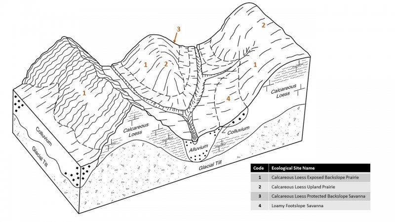
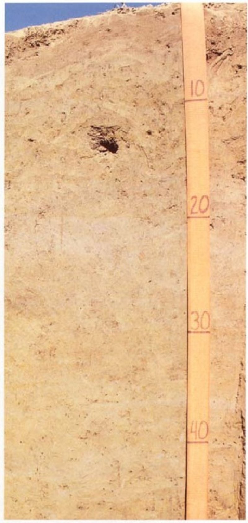
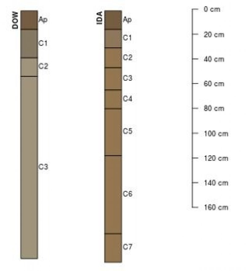
Calcareous Loess Upland Prairies are generally located within the green areas on the map (Figure 1). They occur on summits with slopes less than fifteen percent, upslope from other calcareous loess ecological sites. Soils are Entisols that are well-drained and very deep, formed from loess with a significant component of calcium carbonates at or near the surface, resulting in an alkaline (increased pH) environment. These fine-silty, fertile soils have high soil uniformity resulting in increased nutrient- and water-holding capacity, increased organic matter retention, and good soil aeration that allows deep penetration by plant roots, which generally results in high plant productivity (Catt 2001).
The historic pre-European settlement vegetation on this site was dominated by tallgrass prairie species adapted to dry-mesic habitats irrespective of aspect (Rosburg 1994). Big bluestem (Andropogon gerardii Vitam) and little bluestem (Schizachyrium scoparium (Michx.) Nash) are the dominant monocot species for the ecological site. Other important grasses and grass-likes include sideoats grama (Bouteloua curtipendula (Michx.) Torr.), hairy grama (Bouteloua hirsuta Lag.), sun sedge (Carex inops L.H. Bailey ssp. heliophila (Mack.) Crins), plains muhly (Muhlenbergia cuspidata (Torr. ex Hook.) Rydb), and Indiangrass (Sorghastrum nutans (L.) Nash). Forb species typical of an undisturbed plant community associated with this ecological site include tall false foxglove (Agalinis aspera (Douglas ex Benth.) Britton), rush skeletonplant (Lygodesmia juncea (Pursh) D. Don ex Hook.), yellow sundrops (Calylophus serrulatus (Nutt.) P.H. Raven), and dotted blazing star (Liatris punctata Hook.) (Drobney et al. 2001; Nelson 2010). Leadplant (Amorpha canescens Pursh) and roughleaf dogwood (Cornus drummondii C.A. Mey.) are common shrubs that can be found lightly scattered throughout the prairie (Nelson 2010; Steinauer and Rolfsmeier 2010). Fire was the primary disturbance factor that maintained this site, while drought and native large mammal grazing were secondary factors.
Relative to other calcareous loess prairie ecological sites in the MLRA, the gentle slopes of Calcareous Loess Upland Prairies are slightly moister than the downslope sites resulting in the occurrence of more mesic plant species and greater overall diversity. However, compared to calcareous till prairie sites, species composition suggests a slightly drier condition. Lastly, unlike similar loess prairie ecological sites with a higher clay content, this ecological site has a lower soil moisture and higher coefficient of wetness (i.e. site is drier) as evidenced by the presence of mostly obligate upland species.
Associated sites
| R107XB003MO |
Deep Loess Exposed Backslope Savanna Calcareous loess soils on slopes greater than fifteen percent on north and east slopes, including Dow and Ida |
|---|---|
| R107XB006MO |
Calcareous Loess Exposed Backslope Prairie Calcareous loess soils on slopes greater than 15 percent with south and west aspects, including Dow, Hamburg, and Ida |
Similar sites
| R107XB006MO |
Calcareous Loess Exposed Backslope Prairie Calcareous Loess Exposed Backslope Prairies are similar in composition but frequency and production of little bluestem and sideoats grama are greater in this ecological site; occurs only on shoulders and backslopes |
|---|---|
| R107XB007MO |
Loess Upland Prairie Loess Upland Prairies are similar in supporting a prairie plant community but parent material contains no carbonates and a higher clay content |
| R107XB002MO |
Deep Loess Upland Prairie Deep Loess Upland Prairies are similar in supporting a prairie plant community but parent material contains no carbonates and a higher clay content |
| R107XB027IA |
Calcareous Till Upland Prairie Calcareous Till Upland Prairies are similar in landscape position but parent material is glacial till |
Table 1. Dominant plant species
| Tree |
Not specified |
|---|---|
| Shrub |
Not specified |
| Herbaceous |
(1) Andropogon gerardii |
Click on box and path labels to scroll to the respective text.