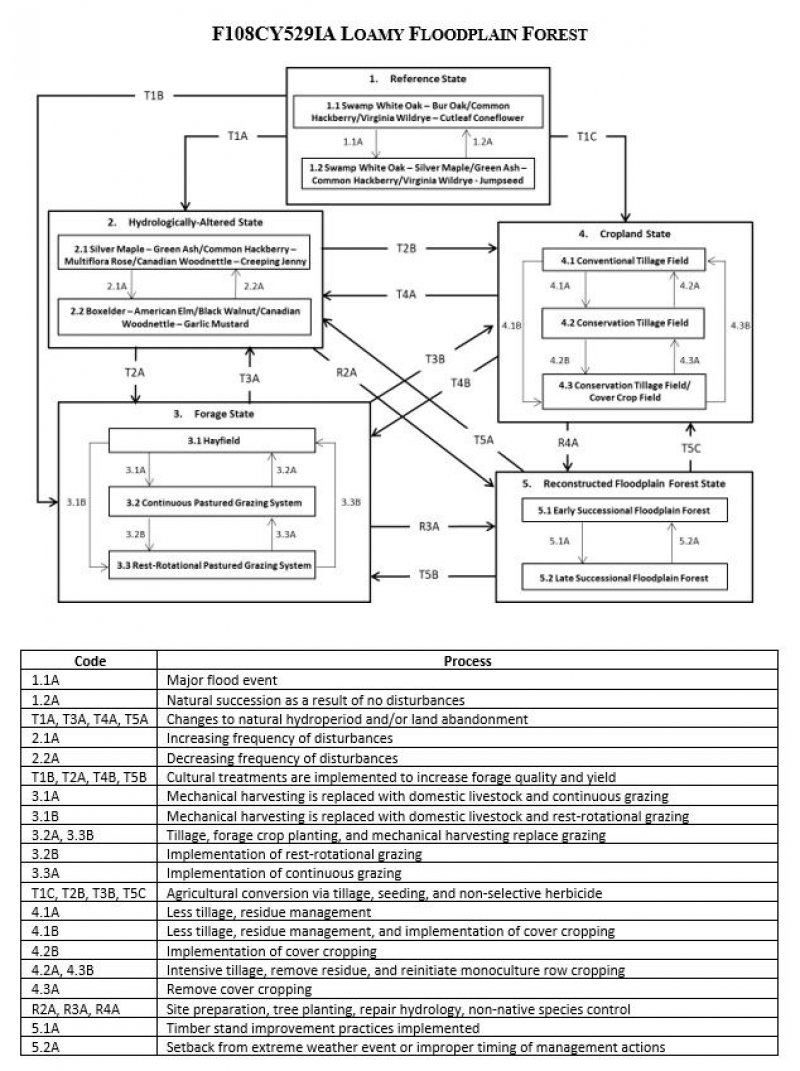
Ecological dynamics
The information in this Ecological Site Description, including the state-and-transition model (STM), was developed based on historical data, current field data, professional experience, and a review of the scientific literature. As a result, all possible scenarios or plant species may not be included. Key indicator plant species, disturbances, and ecological processes are described to inform land management decisions.
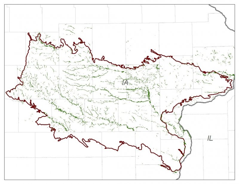
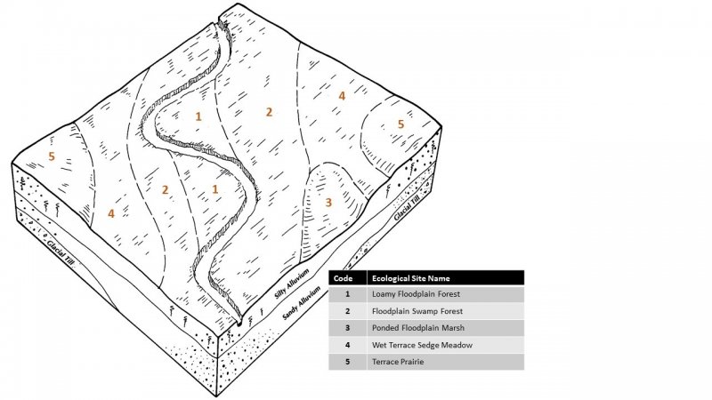
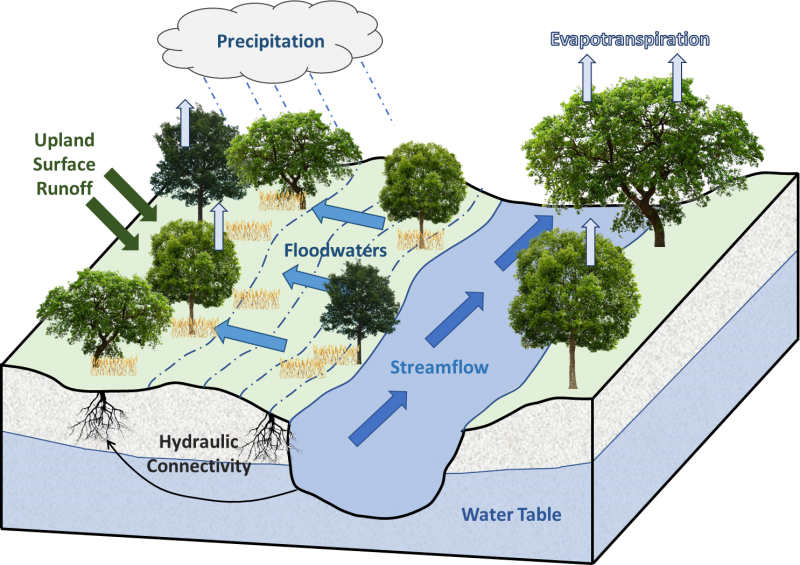
The MLRA lies within the transition zone between the eastern deciduous forests and the tallgrass prairies. The heterogeneous topography of the area results in variable microclimates and fuel matrices that in turn are able to support prairies, savannas, woodlands, and forests. Loamy Floodplain Forests form an aspect of this vegetative continuum. This ecological site occurs on floodplains on somewhat poorly to moderately well-drained soils. Species characteristic of this ecological site consist of hydrophytic woody and herbaceous vegetation.
Occasional flooding is the dominant disturbance factor in Loamy Floodplain Forests, and storm damage and pests are secondary disturbances. Seasonal flooding occurs every two to twenty years, and flooding can persist for up to seven days at a time. Damage to trees from wind storms can vary from minor, patchy effects of individual trees to stand effects that temporarily affect community structure and species richness and diversity (Irland 2000; Peterson 2000). Oaks are susceptible to a variety of pests (e.g., insects, fungi, cankers, wilts), therefore periodic insect and disease outbreaks play an important role in local canopy structure (Snyder 1992).
Today, many Loamy Floodplain Forests have been reduced as a result of conversion to pasture. A few sites have been cleared and drained for agricultural production. Remnant sites have been degraded due to significant changes to the natural hydrologic regime and diminished water quality in the watershed. The state-and-transition model that follows provides a detailed description of each state, community phase, pathway, and transition. This model is based on available experimental research, field observations, literature reviews, professional consensus, and interpretations.
State 1
Reference State
The reference plant community is categorized as an oak bottomland forest community, dominated by upland and hydrophytic oaks and herbaceous vegetation. The two community phases within the reference state are dependent on a regular flood regime. The amount and duration of flooding alters species composition, cover, and extent. Periodic pest outbreaks and wind storms have more localized impacts in the reference phases, but do contribute to overall species composition, diversity, cover, and productivity.
Community 1.1
Swamp White Oak – Bur Oak/Common Hackberry/Virginia Wildrye – Cutleaf Coneflower
Sites in this reference community phase are a closed canopy forest (80 to 100 percent cover) dominated by swamp white oak and bur oak, with subdominants including green ash, American and slippery elm, and silver maple. Common hackberry may be a frequent component of the subcanopy. Trees are large (21 to 33-inch DBH) and range in height from 30 to over 80 feet tall (LANDFIRE 2009). Virginia wildrye and cutleaf coneflower may be dominant and characteristic herbaceous species, respectively (Runkel and Roosa 2014). Other herbaceous species can include nodding fescue (Festuca subverticillata (Pers.) Alexeev), fowl mannagrass (Glyceria striata (Lam.) Hitchc.), Gray’s sedge (Carex grayi Carey), and jumpseed (Polygonum virginanum L.) (NatureServe 2015). Occasional flooding every 2 to 20 years will maintain this phase, but a major flood event can shift the community to an earlier successional floodplain forest, phase 1.2 (Myers and Buchman 1984).
Community 1.2
Swamp White Oak – Silver Maple/Green Ash – Common Hackberry/Virginia Wildrye – Jumpseed
This reference community phase represents a plant community in recovery from a major flood event. Mature swamp white oaks and bur oaks may still be present, but disturbance-tolerant species – such as silver maple, green ash, common hackberry, and eastern cottonwood (Populus deltoides L.) – become important co-dominant species in the tree canopy and subcanopy. Immediately following the flood event, the herbaceous layer is likely to be comprised mostly of annuals. Frequent flooding will maintain this community phase, but lack of disturbances will eventually allow this site to shift back to phase 1.1 (Myers and Buchman 1984).
Pathway 1.1A
Community 1.1 to 1.2
Major flood event.
Pathway 1.2A
Community 1.2 to 1.1
Natural succession as a result of no disturbances.
State 2
Hydrologically-altered State
Agricultural tile drainage, stream channelization, and levee construction in hydrologically-connected waters have drastically changed the natural hydrologic regime of Loamy Floodplain Forests. In addition, increased amounts of precipitation and intensity have amplified flooding events (Pryor et al. 2014). This has resulted in a type conversion from the species-rich forest to a ruderal floodplain forest state. In addition, exotic species have encroached and continuously spread, reducing native diversity and ecosystem stability (Eggers and Reed 2015).
Community 2.1
Silver Maple – Green Ash/Common Hackberry – Multiflora Rose/Canadian Woodnettle – Creeping Jenny
This community phase represents a transition in plant community composition as a result of an altered hydrologic regime. Silver maple, green ash, American elm, and slippery elm become the dominant tree canopy species. Common hackberry, honeylocust (Gleditsia triacanthos L.), and boxelder (Acer negundo L.) are dominant subcanopy species, while roughleaf dogwood (Cornus drummondii C.A. Mey) and multiflora rose (Rosa multiflora L.) are dominant shrubs. The herbaceous layer is nearly continuous but lacking in diversity. Canadian woodnettle (Laportea canadensis (L.) Weddell) and Canadian honewort (Cryptotaenia canadensis (L.) DC.) are common native species, and creeping jenny (Lysimachia nummularia L.) can be a frequently encountered non-native species.
Community 2.2
Boxelder – American Elm/Black Walnut/Canadian Woodnettle – Garlic Mustard
This community phase represents persisting changes to the natural hydrology of the watershed. The overstory canopy continues to shift, becoming dominated by boxelder due to frequent disturbances (Rosario 1988). American elm can be a co-dominant canopy species, and black walnut (Juglans nigra L.) can be present in the subcanopy. The understory may continue to be invaded by more non-native species, such as garlic mustard (Alliaria petiolata (M. Bieb.) Cavara & Grande), as a result of the frequent disturbances.
Pathway 2.2A
Community 2.1 to 2.2
Decreasing frequency of disturbances.
Pathway 2.1A
Community 2.2 to 2.1
Increasing frequency of disturbances.
State 3
Forage State
The forage state occurs when the site is converted to a farming operation that emphasizes domestic livestock production known as grassland agriculture. Fire suppression, periodic cultural treatments (e.g., clipping, drainage, soil amendment applications, planting new species and/or cultivars, mechanical harvesting) and grazing by domesticated livestock transition and maintain this state (USDA-NRCS 2003). Early settlers seeded non-native species, such as smooth brome (Bromus inermis Leyss.) and Kentucky bluegrass (Poa pratensis L.), to help extend the grazing season (Smith 1998). Over time, as lands were continuously harvested or grazed by herds of cattle, the non-native species were able to spread and expand across the landscape, reducing the native species diversity and ecological function. This state is most common on the steeply sloping sites.
Community 3.1
Hayfield
Sites in this community phase consist of forage plants that are planted and mechanically harvested. Mechanical harvesting removes much of the aboveground biomass and nutrients that feed the soil microorganisms (Franzluebbers et al. 2000; USDA-NRCS 2003). As a result, soil biology is reduced leading to decreases in nutrient uptake by plants, soil organic matter, and soil aggregation. Frequent biomass removal can also reduce the site’s carbon sequestration capacity (Skinner 2008).
Community 3.2
Continuous Pastured Grazing
This community phase is characterized by continuous grazing where domestic livestock graze a pasture for the entire season. Depending on stocking density, this can result in lower forage quality and productivity, weed invasions, and uneven pasture use. Continuous grazing can also increase the amount of bare ground and erosion and reduce soil organic matter, cation exchange capacity, water-holding capacity, and nutrient availability and retention (Bharati et al. 2002; Leake et al. 2004; Teague et al. 2011). Smooth brome, Kentucky bluegrass, and white clover (Trifolium repens L.) are common pasture species used in this phase. Their tolerance to continuous grazing has allowed these species to dominate, sometimes completely excluding the native vegetation.
Community 3.3
Periodic-rest Pastured Grazing
This community phase is characterized by periodic-rest grazing where the pasture has been subdivided into several smaller paddocks. Subdividing the pasture in this way allows livestock to utilize one or a few paddocks, while the remaining area is rested allowing plants to restore vigor and energy reserves, deepen root systems, develop seeds, as well as allow seedling establishment (Undersander et al. 2002; USDA-NRCS 2003). Periodic-rest pastured grazing includes deferred periods, rest periods, and periods of high intensity – low frequency, and short duration methods. Vegetation is generally more diverse and can include orchardgrass (Dactylis glomerata L.), timothy (Phleum pretense L.), red clover (Trifolium pratense L.), and alfalfa (Medicago sativa L.). The addition of native prairie species can further bolster plant diversity and, in turn, soil function. This community phase promotes numerous ecosystem benefits including increasing biodiversity, preventing soil erosion, maintaining and enhancing soil quality, sequestering atmospheric carbon, and improving water yield and quality (USDA-NRCS 2003).
Pathway 3.1A
Community 3.1 to 3.2
Mechanical harvesting is replaced with domestic livestock utilizing continuous grazing.
Pathway 3.1B
Community 3.1 to 3.3
Mechanical harvesting is replaced with domestic livestock utilizing periodic-rest grazing.
Pathway 3.2A
Community 3.2 to 3.1
Domestic livestock are removed, and mechanical harvesting is implemented.
Pathway 3.2B
Community 3.2 to 3.3
Periodic-rest grazing replaces continuous grazing.
Pathway 3.3B
Community 3.3 to 3.1
Domestic livestock are removed, and mechanical harvesting is implemented.
Pathway 3.3A
Community 3.3 to 3.2
Continuous grazing replaces periodic-rest grazing.
State 4
Cropland State
The low topographic relief across the MLRA has resulted in nearly the entire area being converted to agriculture (Eilers and Roosa 1994). The continuous use of tillage, row-crop planting, and chemicals (i.e., herbicides, fertilizers, etc.) has effectively eliminated the reference community and many of its natural ecological functions in favor of crop production. Corn and soybeans are the dominant crops for the site, and oats (Avena L.) and alfalfa (Medicago sativa L.) may be rotated periodically. These areas are likely to remain in crop production for the foreseeable future. This state is most common on the gently sloping sites.
Community 4.1
Conventional Tillage Field
Sites in this community phase typically consist of monoculture row-cropping maintained by conventional tillage practices. They are cropped in either continuous corn or alternating periods of corn and soybean crops. The frequent use of deep tillage, low crop diversity, and bare soil conditions during the non-growing season negatively impacts soil health. Under these practices, soil aggregation is reduced or destroyed, soil organic matter is reduced, erosion and runoff are increased, and infiltration is decreased, which can ultimately lead to undesirable changes in the hydrology of the watershed (Tomer et al. 2005).
Community 4.2
Conservation Tillage Field
This community phase is characterized by periodically alternating crops and utilizing various conservation tillage methods to promote soil health and reduce erosion. Conservation tillage methods include strip-till, ridge-till, vertical-till, or no-till planting operations. Strip-till keeps seedbed preparation to narrow bands less than one-third the width of the row where crop residue and soil consolidation are left undisturbed in-between seedbed areas. Strip-till planting may be completed in the fall and nutrient application either occurs simultaneously or at the time of planting. Ridge-till uses specialized equipment to create ridges in the seedbed and vegetative residue is left on the surface in between the ridges. Weeds are controlled with herbicides and/or cultivation, seedbed ridges are rebuilt during cultivation, and soils are left undisturbed from harvest to planting. Vertical-till operations employ machinery that lightly tills the soil and cuts up crop residue, mixing some of the residue into the top few inches of the soil while leaving a large portion on the surface. No-till management is the most conservative, disturbing soils only at the time of planting and fertilizer application. Compared to conventional tillage operations, conservation tillage methods can improve soil ecosystem function by reducing soil erosion, increasing organic matter and water availability, improving water quality, and reducing soil compaction.
Community 4.3
Conservation Tillage with Cover Crop Field
This community phase applies conservation tillage methods as described above as well as adds cover crop practices. Cover crops typically include nitrogen-fixing species (e.g., legumes), small grains (e.g., rye, wheat, oats), or forage covers (e.g., turnips, radishes, rapeseed). The addition of cover crops not only adds plant diversity but also promotes soil health by reducing soil erosion, limiting nitrogen leaching, suppressing weeds, increasing soil organic matter, and improving the overall soil ecosystem. In the case of small grain cover crops, surface cover and water infiltration are increased, while forage covers can be used to graze livestock or support local wildlife. Of the three community phases for this state, this phase promotes the greatest soil sustainability and improves ecological functioning within a row crop operation.
Pathway 4.1A
Community 4.1 to 4.2
Tillage operations are greatly reduced, alternating crops occurs on a regular interval, and crop residue remains on the soil surface.
Pathway 4.1B
Community 4.1 to 4.3
Tillage operations are greatly reduced or eliminated, alternating crops occurs on a regular interval, crop residue remains on the soil surface, and cover crops are planted following crop harvest.
Pathway 4.2A
Community 4.2 to 4.1
Intensive tillage is utilized, and monoculture row-cropping is established.
Pathway 4.2B
Community 4.2 to 4.3
Cover crops are implemented to minimize soil erosion.
Pathway 4.3B
Community 4.3 to 4.1
Intensive tillage is utilized, cover crops practices are abandoned, monoculture row-cropping is established on a more-or-less continuous basis.
Pathway 4.3A
Community 4.3 to 4.2
Cover crop practices are abandoned.
State 5
Reconstructed Floodplain Forest State
The combination of natural and anthropogenic disturbances occurring today has resulted in numerous ecosystem health issues, and restoration back to the historic reference state may not be possible. Many natural forest communities are being stressed by non-native diseases and pests, habitat fragmentation, permanent changes in hydrologic regimes, and overabundant deer populations on top of naturally-occurring disturbances (severe weather and native pests) (Flickinger 2010). However, these habitats provide multiple ecosystem services including carbon sequestration; clean air and water; soil conservation; biodiversity support; wildlife habitat; as well as a variety of cultural activities (e.g., hiking, hunting) (Millennium Ecosystem Assessment 2005; Flickinger 2010). Therefore, conservation of floodplain forests should still be pursued. Habitat reconstructions are an important tool for repairing natural ecological functioning and providing habitat protection for numerous species of Loamy Floodplain Forests. Therefore, ecological restoration should aim to aid the recovery of degraded, damaged, or destroyed ecosystems. A successful restoration will have the ability to structurally and functionally sustain itself, demonstrate resilience to the ranges of stress and disturbance, and create and maintain positive biotic and abiotic interactions (SER 2002). The reconstructed forest state is the result of a long-term commitment involving a multi-step, adaptive management process.
Community 5.1
Early Successional Reconstructed Forest
This community phase represents the early community assembly from forest reconstruction. It is highly dependent on the current condition of the site based on past and current land management actions, invasive species, and proximity to land populated with non-native pests and diseases. Therefore, no two sites will have the same early successional composition. Technical forestry assistance should be sought to develop suitable conservation management plans.
Community 5.2
Late Successional Reconstructed Forest
Appropriately timed management practices (e.g. forest stand improvement, continuing integrated pest management) applied to the early successional community phase can help increase the stand maturity, pushing the site into a late successional community phase over time. A late successional reconstructed forest will have an uneven-aged, closed canopy and a well-developed understory.
Pathway 5.1A
Community 5.1 to 5.2
Application of stand improvement practices in line with a developed management plan.
Pathway 5.2A
Community 5.2 to 5.1
Reconstruction experiences a setback from extreme weather event or improper timing of management actions.
Transition T1A
State 1 to 2
Altered hydrology throughout the watershed transitions the site to the hydrologically-altered state (2).
Transition T1B
State 1 to 3
Woody species removal and cultural treatments to enhance forage quality and yield transition the site to the forage state (3).
Transition T1C
State 1 to 4
Woody species removal, tillage, seeding of agricultural crops, and non-selective herbicide transition the site to the cropland state (4).
Transition T2A
State 2 to 3
Woody species removal and cultural treatments to enhance forage quality and yield transition the site to the forage state (3).
Transition T2B
State 2 to 4
Woody species removal, tillage, seeding of agricultural crops, and non-selective herbicide transition the site to the cropland state (4).
Restoration pathway R2A
State 2 to 5
Site preparation, tree planting, timber stand improvement, non-native species control, and water control structures installed to improve and regulate hydrology transition this site to the reconstructed forest state (5).
Transition T3A
State 3 to 2
Land abandonment transitions the site to the hydrologically-altered state (2).
Transition T3B
State 3 to 4
Tillage, seeding of agricultural crops, and non-selective herbicide transition this site to the cropland state (4).
Restoration pathway R3A
State 3 to 5
Site preparation, tree planting, timber stand improvement, non-native species control, and water control structures installed to improve and regulate hydrology transition this site to the reconstructed forest state (5).
Transition T4A
State 4 to 2
Land abandonment transitions the site to the hydrologically-altered state (2).
Transition T4B
State 4 to 3
Cultural treatments to enhance forage quality and yield transitions the site to the forage state (3).
Restoration pathway R4A
State 4 to 5
Site preparation, tree planting, timber stand improvement, non-native species control, and water control structures installed to improve and regulate hydrology transition this site to the reconstructed forest state (5).
Transition T5A
State 5 to 2
Removal of water control structures and unmanaged invasive species populations transition this site to the hydrologically-altered state (2).
Transition T5B
State 5 to 3
Tree removal and cultural treatments to enhance forage quality and yield transition the site to the forage state (3).
Transition T5C
State 5 to 4
Tree removal, tillage, seeding of agricultural crops, and non-selective herbicide transition this site to the cropland state (4).