Natural Resources
Conservation Service
Ecological site F108XD757IA
Sandstone Upland Woodland
Last updated: 10/17/2024
Accessed: 04/02/2025
General information
Provisional. A provisional ecological site description has undergone quality control and quality assurance review. It contains a working state and transition model and enough information to identify the ecological site.

Figure 1. Mapped extent
Areas shown in blue indicate the maximum mapped extent of this ecological site. Other ecological sites likely occur within the highlighted areas. It is also possible for this ecological site to occur outside of highlighted areas if detailed soil survey has not been completed or recently updated.
MLRA notes
Major Land Resource Area (MLRA): 108X–Illinois and Iowa Deep Loess and Drift
The Illinois and Iowa Deep Loess and Drift, Western Part MLRA covers parts of both Iowa and Missouri and is known locally as part of the Southern Iowa Drift Plain. A silty loess deposit of varying thickness (5 to 20 feet) covers a series of glacial advances known collectively as pre-Illinoisan till. This till, deposited more than half a million years ago, was subjected to multiple instances of extreme erosion as well as periods of subdued erosion and intense weathering. The loess is thickest in the western part of the MLRA and generally thins eastward. In some areas, the loess has been removed and the older weathered till, called a “paleosol,” entirely exposed. These highly weathered soils, or paleosols, have a high content of clay, which slows the downward movement of water through the profile and causes water to move laterally instead of vertically. Wet areas, or “side-hill seeps,” commonly form where these paleosols become exposed along hillsides (Prior, 1991).
The dominant soil orders in this MLRA are Mollisols and Alfisols and, to a lesser extent, Entisols and Inceptisols. Most of the soils are Udolls or Udalfs. Aquolls are on the flatter interfluves. The soils in the area dominantly have a mesic soil temperature regime, an aquic or udic soil moisture regime, and mixed mineralogy. They generally are very deep, well drained to poorly drained, and silty, loamy, or clayey. These soils on uplands include somewhat poorly drained, nearly level Argiudolls (Macksburg series); moderately well drained, gently sloping to strongly sloping Argiudolls (Sharpsburg series); poorly drained, nearly level Argiaquolls (Winterset series); and well drained strongly, sloping to steep Hapludalfs (Gara, Lindley, Ladoga, and Armstrong series) (USDA-NRCS, 2006). The western part of the Illinois and Iowa Deep Loess and Drift is a segment of three other MLRAs within the Central Feed Grains and Livestock Region. The other areas are: the West-Central part (108C), the East-Central part (108B) and the Eastern part (108A).
Classification relationships
Major Land Resource Area (MLRA): Illinois and Iowa Deep Loess and Drift, Western Part (108D)
USFS Subregions: Central Dissected Till Plains Section (251C); Loess Hills (251Cb) and Central Dissected Till and Loess Plain (251Cc) Subsections (Cleland et al. 2007)
Relationship to Other Established Classifications:
NatureServe Classification: Ecological System: North-Central Interior Dry-Mesic Oak Forest and Woodland (4116); Ecological Association: Central Midwest White Oak Mixed Oak Woodland (NatureServe, 2013)
Landfire Biophysical Setting: North-Central Interior Dry-Mesic Oak Forest and Woodland (4313100) (Landfire, 2009)
Ecological site concept
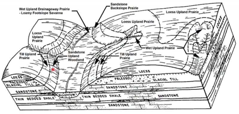
These sites formed in sandstone residuum and can be found on hillslopes on uplands. Typically these sites are located down slope from till ecological sites. Soils are typically Alfisols and are moderately deep (24 to 40 inches) to paralithic contact. Plant communities consist of mostly trees and few grasses forbs and shrubs.
Associated sites
| R108XD824IA |
Wet Upland Drainageway Prairie Fine and fine-silty textured soils include Ackmore, Colo, Judson, Vesser and Zook series. |
|---|---|
| R108XD841IA |
Loamy Footslope Savanna Fine-loamy and fine-silty soils including Arbor, Ely, Judson and Olmitz series. |
| R108XD863IA |
Till Upland Prairie Till Upland Prairie. Fine and fine loamy soils, including Adair, Armstrong, Bucknell, Gara, Lamoni and Shelby series. |
Similar sites
| R108XD767IA |
Sandstone Backslope Prairie Fine loamy, course loamy and sandy soils including Hesch, Histon and Montieth series. |
|---|---|
| R108XD767IA |
Sandstone Backslope Prairie Sandstone Backslope Prairie. Fine-loamy, coarse-loamy and sandy soils including Hesch, Hixton and Montieth series. |
Table 1. Dominant plant species
| Tree |
(1) Quercus alba |
|---|---|
| Shrub |
Not specified |
| Herbaceous |
(1) Carex pensylvanica |
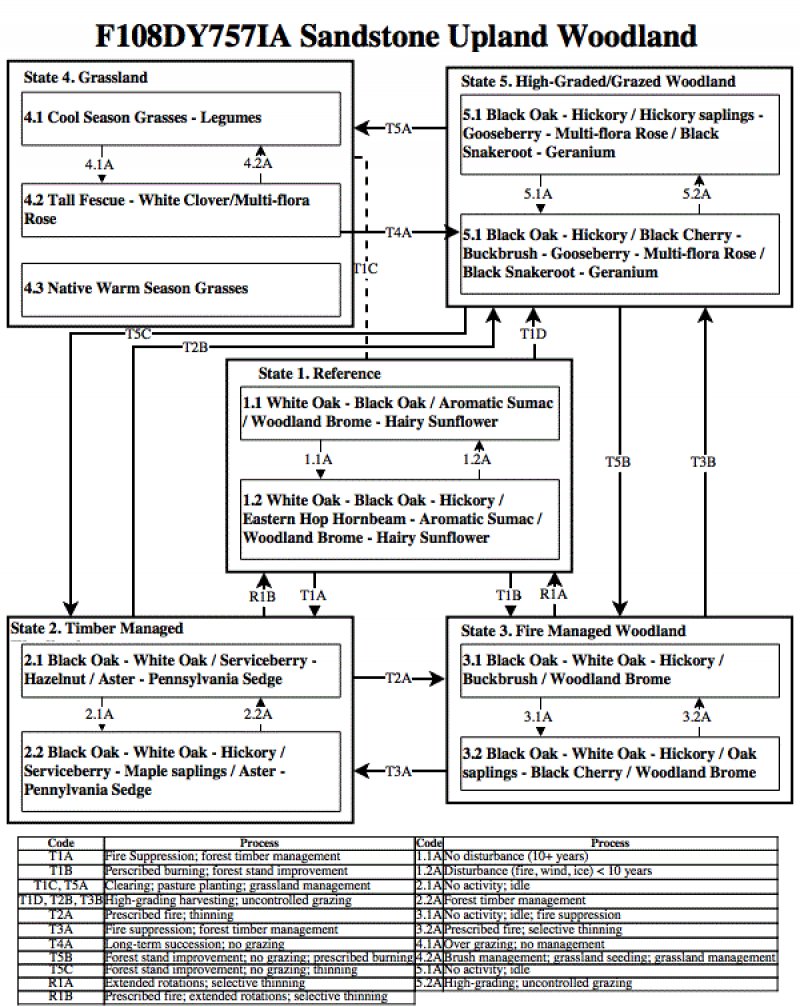
Click on box and path labels to scroll to the respective text.