Natural Resources
Conservation Service
Ecological site R109XY005MO
Loamy Floodplain Prairie
Last updated: 7/02/2024
Accessed: 04/11/2026
General information
Provisional. A provisional ecological site description has undergone quality control and quality assurance review. It contains a working state and transition model and enough information to identify the ecological site.
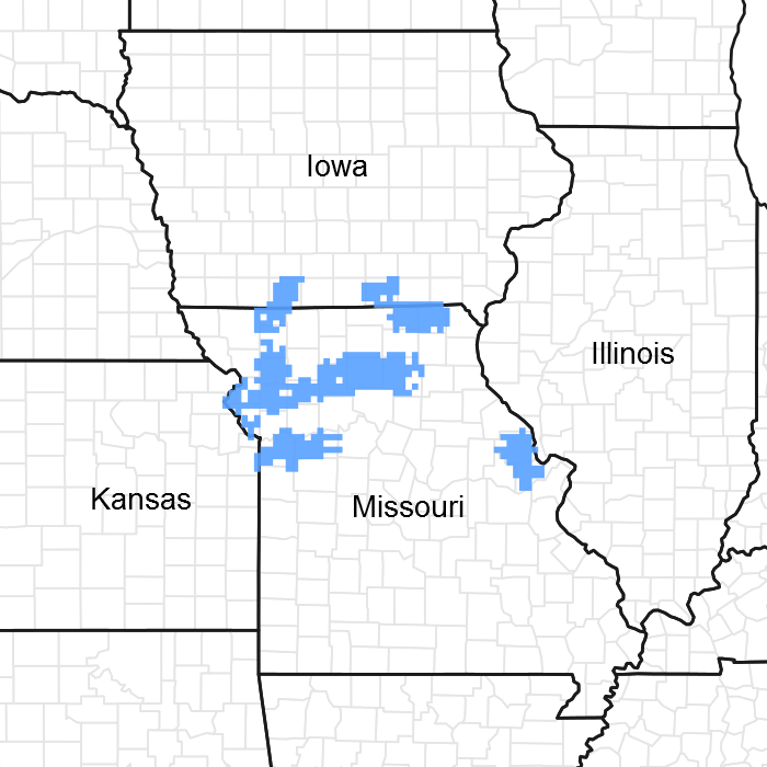
Figure 1. Mapped extent
Areas shown in blue indicate the maximum mapped extent of this ecological site. Other ecological sites likely occur within the highlighted areas. It is also possible for this ecological site to occur outside of highlighted areas if detailed soil survey has not been completed or recently updated.
MLRA notes
Major Land Resource Area (MLRA): 109X–Iowa and Missouri Heavy Till Plain
The Iowa and Missouri Heavy Till Plain is an area of rolling hills interspersed with interfluve divides and alluvial valleys. Elevation ranges from about 660 feet (200 meters) along the lower reaches of rivers, to about 980 feet (300 meters) on stable interfluve summits in southern Iowa. Relief is about 80 to 160 feet (25 to 50 meters) between major streams and adjacent interfluve summits. Most of the till plain drains south to the Missouri River via the Grand and Chariton River systems, but the northeastern portion drains southeast to the Mississippi River. Loess caps the pre-Illinoisan aged till on interfluves, whereas the till is exposed on side slopes. Mississippian aged limestone and Pennsylvanian aged sandstone and shale crop out on lower slopes in some areas.
Classification relationships
Terrestrial Natural Community Type in Missouri (Nelson, 2010):
The reference state for this ecological site is most similar to a Wet-Mesic Bottomland Prairie.
National Vegetation Classification System Vegetation Association (NatureServe, 2010):
The reference state for this ecological site is most similar to.
Geographic relationship to the Missouri Ecological Classification System (Nigh & Schroeder, 2002):
This ecological site occurs in several Land Type Associations, primarily within the following Subsections:
Chariton River Hills
Grand River Hills
Wyaconda River Dissected Till Plains
Ecological site concept
NOTE: This is a “provisional” Ecological Site Description (ESD) that is under development. It contains basic ecological information that can be used for conservation planning, application and land management. As additional information is collected, analyzed and reviewed, this ESD will be refined and published as “Approved”.
Loamy Floodplain Prairies are common in smaller stream floodplains throughout the MLRA and adjacent areas. Soils are very deep and loamy, and subject to flooding. The reference plant community is prairie dominated by Indiangrass, big bluestem, little bluestem and sideoats grama, and a wide variety of prairie wildflowers.
Associated sites
| R109XY018MO |
Loamy Footslope Savanna Loamy Footslope Savannas are on adjacent upland footslopes in places. |
|---|---|
| R109XY031MO |
Wet Floodplain Prairie Wet Floodplain Prairies are often in adjacent, backswamp positions farther from the stream channel. |
| R109XY046MO |
Till Upland Savanna Till Upland Savanna is the dominant upland ecological site across most of the geographic range of this site. |
Similar sites
| R109XY028MO |
Loamy Upland Drainageway Savanna Loamy Upland Drainageway Savannas are in narrower upland floodplains and generally have higher densities of large trees. Herbaceous species composition is very similar. |
|---|
Table 1. Dominant plant species
| Tree |
(1) Quercus macrocarpa |
|---|---|
| Shrub |
(1) Salix humilis |
| Herbaceous |
(1) Andropogon gerardii |
Physiographic features
This site is on floodplains and floodplain steps, with slopes of 0 to 3 percent. The site generates some runoff to adjacent lower floodplain sites, and receives some runoff from stream terraces and uplands. This site is subject to flooding.
The following figure (adapted from Ferguson, 1999) shows the typical landscape position of this ecological site, and landscape relationships among the major ecological sites of the floodplain and stream terrace systems and adjacent uplands. This site is within the area labeled as “5” on the figure, and typically contains the active stream channel of the floodplain system. Wet Floodplain Prairie sites are often in adjacent, backswamp positions farther from the channel. Larger floodplain systems may contain stream terrace ecological sites, such as the Wet Terrace Prairie in the figure. Several sites occur in adjacent upland positions, particularly the Till and Footslope sites shown in the figure.
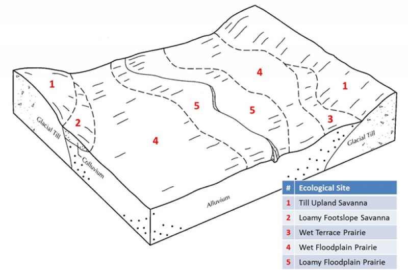
Figure 2. Landscape relationships for this ecological site
Table 2. Representative physiographic features
| Landforms |
(1)
Flood plain
(2) Flood-plain step |
|---|---|
| Flooding duration | Brief (2 to 7 days) to long (7 to 30 days) |
| Flooding frequency | Rare to occasional |
| Elevation | 600 – 1,300 ft |
| Slope | 3% |
| Water table depth | 24 – 48 in |
| Aspect | Aspect is not a significant factor |
Climatic features
The Iowa and Missouri Heavy Till Plain MLRA has a continental type of climate marked by strong seasonality. In winter, dry-cold air masses, unchallenged by any topographic barriers, periodically swing south from the northern plains and Canada. If they invade reasonably humid air, snowfall and rainfall result. In summer, moist, warm air masses, equally unchallenged by topographic barriers, swing north from the Gulf of Mexico and can produce abundant amounts of rain, either by fronts or by convectional processes. In some summers, high pressure stagnates over the region, creating extended droughty periods. Spring and fall are transitional seasons when abrupt changes in temperature and precipitation may occur due to successive, fast-moving fronts separating contrasting air masses.
This MLRA experiences small regional differences in climates that grade inconspicuously into each other. The basic gradient for most climatic characteristics is along a line from north to south. Both mean annual temperature and precipitation exhibit fairly minor gradients along this line. Mean January minimum temperature follows the north-to-south gradient. However, mean July maximum temperature shows hardly any geographic variation in the region. Mean July maximum temperatures have a range of only two to three degrees across the region.
Mean annual precipitation varies along the same gradient as temperature – lower annual precipitation in the north, higher in the south. Seasonality in precipitation is very pronounced due to strong continental influences. June precipitation, for example, averages four to five times greater than January precipitation. During years when precipitation comes in a fairly normal manner, moisture is stored in the top layers of the soil during the winter and early spring, when evaporation and transpiration are low. During the summer months the loss of water by evaporation and transpiration is high, and if rainfall fails to occur at frequent intervals, drought will result. Drought directly influences ecological communities by limiting water supplies, especially at times of high temperatures and high evaporation rates. Drought indirectly affects ecological communities by increasing plant and animal susceptibility to the probability and severity of fire. Frequent fires encourage the development of grass/forb dominated communities and understories.
Superimposed upon the basic MLRA climatic patterns are local topographic influences that create topoclimatic, or microclimatic variations. For example, air drainage at nighttime may produce temperatures several degrees lower in valley bottoms than on side slopes. At critical times during the year, this phenomenon may produce later spring or earlier fall freezes in valley bottoms. Slope orientation is an important topographic influence on climate. Summits and south-and-west-facing slopes are regularly warmer and drier, supporting more grass dominated communities than adjacent north- and-east-facing slopes that are cooler and moister that support more woody dominated communities. Finally, the cooler microclimate within a canopied forest is measurably different from the climate of a more open and warmer grassland or savanna area.
Source: University of Missouri Climate Center - http://climate.missouri.edu/climate.php; Land Resource Regions and Major Land Resource Areas of the United States, the Caribbean, and the Pacific Basin, United States Department of Agriculture Handbook 296 - http://soils.usda.gov/survey/geography/mlra/
Table 3. Representative climatic features
| Frost-free period (characteristic range) | 145-155 days |
|---|---|
| Freeze-free period (characteristic range) | 164-185 days |
| Precipitation total (characteristic range) | 36-41 in |
| Frost-free period (actual range) | 140-156 days |
| Freeze-free period (actual range) | 163-188 days |
| Precipitation total (actual range) | 36-42 in |
| Frost-free period (average) | 149 days |
| Freeze-free period (average) | 176 days |
| Precipitation total (average) | 39 in |
Figure 3. Monthly precipitation range
Figure 4. Monthly minimum temperature range
Figure 5. Monthly maximum temperature range
Figure 6. Monthly average minimum and maximum temperature
Figure 7. Annual precipitation pattern
Figure 8. Annual average temperature pattern
Climate stations used
-
(1) AMITY 4 NE [USC00230143], Maysville, MO
-
(2) BROOKFIELD [USC00230980], Brookfield, MO
-
(3) GRANT CITY [USC00233369], Grant City, MO
-
(4) MEMPHIS [USC00235492], Memphis, MO
-
(5) KEARNEY 3E [USC00234382], Kearney, MO
Influencing water features
This ecological site is in floodplains of perennial streams where prairie is extensive in the uplands. Stream levels typically respond quickly to storm events, especially in watersheds where surface runoff is dominant. Short- to medium- duration flooding is common in many areas, particularly during spring and early summer storm events. Constructed levees, often accompanied by stream channelization, and surface drainage systems have altered the hydrology and flooding dynamics in many places. Streambeds are typically incised into the surrounding floodplain by as much as 10 feet.
Soils in this ecological site typically have seasonal water tables below about two feet in the winter and spring, generally receding with the falling river levels in the early summer. The water table has a minimal effect on the vegetative community.
Soil features
These soils have no rooting restriction. They were formed under a mixture of woodland and prairie vegetation, with periodic depositional flood events. Organic matter content is high. Parent material is alluvium. They have silt loam surface horizons, and loamy substrata. They are well drained. Soil series associated with this site include Kennebec.
Table 4. Representative soil features
| Parent material |
(1)
Alluvium
|
|---|---|
| Surface texture |
(1) Silt loam |
| Family particle size |
(1) Loamy |
| Drainage class | Moderately well drained |
| Permeability class | Moderate |
| Surface fragment cover <=3" | Not specified |
| Surface fragment cover >3" | Not specified |
| Available water capacity (0-40in) |
8 – 9 in |
| Calcium carbonate equivalent (0-40in) |
Not specified |
| Electrical conductivity (0-40in) |
2 mmhos/cm |
| Sodium adsorption ratio (0-40in) |
Not specified |
| Soil reaction (1:1 water) (0-40in) |
5.6 – 7.3 |
| Subsurface fragment volume <=3" (Depth not specified) |
Not specified |
| Subsurface fragment volume >3" (Depth not specified) |
Not specified |
Ecological dynamics
Information contained in this section was developed using historical data, professional experience, field reviews, and scientific studies. The information presented is representative of very complex vegetation communities. Key indicator plants, animals and ecological processes are described to help inform land management decisions. Plant communities will differ across the MLRA because of the naturally occurring variability in weather, soils, and aspect. The Reference Plant Community is not necessarily the management goal. The species lists are representative and are not botanical descriptions of all species occurring, or potentially occurring, on this site. They are not intended to cover every situation or the full range of conditions, species, and responses for the site.
The reference plant community is characterized as a tallgrass prairie unit dominated by big bluestem, Indiangrass, switchgrass, eastern gamagrass and a wide variety of prairie wildflowers while other species such as Culver’s root, Michigan lily, and Virginia bunchflower added to the mix of floodplain prairie species. Slightly higher areas within or at the edge of the floodplains supported widely scattered bur oak, pin oak, elm, shellbark hickory and willow.
These areas flooded periodically. In addition to the flooding, fire played a key role, likely occurring at least once every 3 years. Fire removed dead plant litter and provided room for a lush growth of prairie vegetation. Fire also controlled woody species. During fire free intervals woody species would have increased in abundance and spread out onto the prairie. Grazing by native large herbivores, such as bison, elk, and white-tailed deer, furthermore impacted these sites. Their activities altered the composition, fuel loads and structure of the vegetation, adding to the diversity of structure and composition.
Today, Loamy Floodplain Prairies are nearly extirpated from the region as the former floodplain prairies have been converted to intensive agriculture or non-native pasture. No reference quality remnants exist. While re-establishing prairie on agriculture sites is beneficial to wildlife, restoration to the reference state from agricultural land is a long term proposition, potentially expensive and with uncertain outcomes.
A State and Transition Diagram follows. Detailed descriptions of each state, transition, plant community, and pathway follow the model. This model is based on available experimental research, field observations, professional consensus, and interpretations. It is likely to change as knowledge increases.
State and transition model
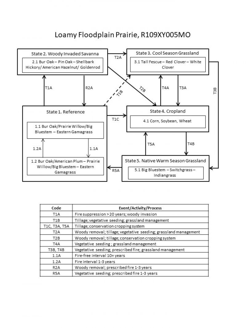
Figure 9. State and transition diagram for this ecological site
More interactive model formats are also available.
View Interactive Models
More interactive model formats are also available.
View Interactive Models
Click on state and transition labels to scroll to the respective text
Ecosystem states
States 1 and 5 (additional transitions)
State 1 submodel, plant communities
State 2 submodel, plant communities
State 3 submodel, plant communities
State 4 submodel, plant communities
State 5 submodel, plant communities
State 1
Reference
This State is native tall grass prairie dominated by big bluestem, eastern gama grass, and a wide variety of prairie wildflowers. In some cases, bur oak, pin oak, elm, American hazelnut, prairie willow and wild plum occurred in small groves or as scattered individuals across the prairie landscape. Two phases can occur that will transition back and forth depending on fire frequencies. Longer fire free intervals will allow woody species to increase such as bur oak, prairie willow, dogwoods and wild plum. When fire intervals shorten these woody species will decrease or be eliminated. This state is believed to be expatriated. All sites have been converted to cool season grassland and intensive agriculture cropland.
Dominant plant species
-
bur oak (Quercus macrocarpa), tree
-
prairie willow (Salix humilis), shrub
-
American plum (Prunus americana), shrub
-
big bluestem (Andropogon gerardii), other herbaceous
-
eastern gamagrass (Tripsacum dactyloides), other herbaceous
Community 1.1
Bur Oak/Prairie Willow/Big Bluestem – Eastern Gama Grass
This phase is dominated by big bluestem, Indian grass, switch grass, eastern gama grass and a wide variety of prairie wildflowers while other species such as Culver’s root, Michigan lily, and bunchflower added to the mix of floodplain prairie species. These areas flooded periodically. In addition to the flooding, fire played a key role, likely occurring at least once every 3 years.
Forest overstory. The Forest Overstory Species list is based on commonly occurring species listed in Nelson (2010).
Forest understory. The Forest Understory list is based on commonly occurring species listed in Nelson (2010).
Dominant plant species
-
bur oak (Quercus macrocarpa), tree
-
prairie willow (Salix humilis), shrub
-
big bluestem (Andropogon gerardii), other herbaceous
-
eastern gamagrass (Tripsacum dactyloides), other herbaceous
Community 1.2
Bur Oak/Wild Plum – Prairie Willow/Big Bluestem – Eastern Gama Grass
This phase is characterized by fire free intervals. Woody species would have increased in abundance and spread out onto the prairie. Slightly higher areas within or at the edge of the floodplains supported widely scattered bur oak, pin oak, elm, shellbark hickory and willow.
Dominant plant species
-
bur oak (Quercus macrocarpa), tree
-
American plum (Prunus americana), shrub
-
prairie willow (Salix humilis), shrub
-
big bluestem (Andropogon gerardii), other herbaceous
-
eastern gamagrass (Tripsacum dactyloides), other herbaceous
Pathway 1.1A
Community 1.1 to 1.2
Fire-free interval 10+ years
Pathway 1.2A
Community 1.2 to 1.1
Fire interval 1-3 years
State 2
Woody Invaded Savanna
Degraded reference states that have experienced fire suppression for 20 or more years will transition to this state. With fire suppression, woody species such as bur oak, shellbark hickory and pin oak will begin to increase transitioning this state from a prairie to a Woody Invaded Savanna. Native ground cover will also decrease and invasive species such as tall fescue may begin to increase. Transition from this state to cool season grasslands (State 3) or intensive cropland (State 4) was very common.
Dominant plant species
-
bur oak (Quercus macrocarpa), tree
-
pin oak (Quercus palustris), tree
-
shellbark hickory (Carya laciniosa), tree
-
American hazelnut (Corylus americana), shrub
-
goldenrod (Oligoneuron), other herbaceous
Community 2.1
Bur Oak – Pin Oak – Shellbark Hickory/ American Hazelnut/ Goldenrod
State 3
Cool Season Grassland
Conversion of other states to non-native cool season species such as tall fescue, white clover, and red clover has been common in this area. Occasionally, these pastures will have scattered bur oaks. Long term uncontrolled grazing and a lack of grassland management can cause significant soil erosion and compaction and increases in less productive species such as Kentucky bluegrass and weedy forbs such as ironweed. A return to the Reference State may be impossible and costly, requiring a very long term series of management options.
Dominant plant species
-
tall fescue (Schedonorus arundinaceus), other herbaceous
-
red clover (Trifolium pratense), other herbaceous
-
white clover (Trifolium repens), other herbaceous
Community 3.1
Tall Fescue – Red Clover – White Clover
Dominant plant species
-
tall fescue (Schedonorus arundinaceus), other herbaceous
-
red clover (Trifolium pratense), other herbaceous
-
white clover (Trifolium repens), other herbaceous
State 4
Cropland
This is the dominant State that exists currently with intensive cropping of corn, soybeans, and wheat occurring. Some conversion to cool season hayland occurs for a limited period of time before transitioning back to cropland. Limited acres are sometimes converted to native warm season grassland.
Community 4.1
Corn, Soybean, Wheat
State 5
Native Warm Season Grassland
Conversion from the Cool Season Grassland (State 3) or the Cropland (State 4) to this state is increasing due to renewed interest in warm season grasses as a supplement to cool season grazing systems or as a native restoration activity. This State is the most easily transformable state back to a Reference State. Substantial restoration time, money and management inputs will still be needed.
Dominant plant species
-
big bluestem (Andropogon gerardii), other herbaceous
-
switchgrass (Panicum virgatum), other herbaceous
-
Indiangrass (Sorghastrum), other herbaceous
Community 5.1
Big Bluestem – Switchgrass – Indiangrass
Dominant plant species
-
big bluestem (Andropogon gerardii), other herbaceous
-
switchgrass (Panicum virgatum), other herbaceous
-
Indiangrass (Sorghastrum), other herbaceous
Transition T1A
State 1 to 2
Fire suppression >20 years; woody invasion
Transition T2A
State 1 to 3
Woody removal; tillage; vegetative seeding; grassland management
Transition T2B
State 1 to 4
Woody removal; tillage; conservation cropping system
Restoration pathway R2A
State 2 to 1
Woody removal; prescribed fire 1-3 years
Transition T1B
State 2 to 3
Tillage; vegetative seeding; grassland management
Transition T2B
State 2 to 4
Woody removal; tillage; conservation cropping system
Transition T3A
State 3 to 4
Tillage; conservation cropping system
Transition T3B
State 3 to 5
Vegetative seeding; prescribed fire; grassland management
Restoration pathway T4A
State 4 to 3
Vegetative seeding; grassland management
Transition T4B
State 4 to 5
Vegetative seeding; prescribed fire; grassland management
Restoration pathway R5A
State 5 to 1
Vegetative seeding; prescribed fire 1-3 years
Restoration pathway T5A
State 5 to 4
Tillage; conservation cropping system
Additional community tables
Table 5. Community 1.1 forest overstory composition
| Common name | Symbol | Scientific name | Nativity | Height (ft) | Canopy cover (%) | Diameter (in) | Basal area (square ft/acre) |
|---|---|---|---|---|---|---|---|
|
Tree
|
|||||||
| pin oak | QUPA2 | Quercus palustris | Native | – | 0–5 | – | – |
| shellbark hickory | CALA21 | Carya laciniosa | Native | – | 0–5 | – | – |
| bur oak | QUMA2 | Quercus macrocarpa | Native | – | 0–5 | – | – |
Table 6. Community 1.1 forest understory composition
| Common name | Symbol | Scientific name | Nativity | Height (ft) | Canopy cover (%) | |
|---|---|---|---|---|---|---|
|
Grass/grass-like (Graminoids)
|
||||||
| big bluestem | ANGE | Andropogon gerardii | Native | – | 30–50 | |
| eastern gamagrass | TRDA3 | Tripsacum dactyloides | Native | – | 10–30 | |
| little bluestem | SCSC | Schizachyrium scoparium | Native | – | 10–20 | |
| Indiangrass | SONU2 | Sorghastrum nutans | Native | – | 10–20 | |
| switchgrass | PAVI2 | Panicum virgatum | Native | – | 10–20 | |
| prairie dropseed | SPHE | Sporobolus heterolepis | Native | – | 5–10 | |
|
Forb/Herb
|
||||||
| Missouri goldenrod | SOMI2 | Solidago missouriensis | Native | – | 5–20 | |
| ashy sunflower | HEMO2 | Helianthus mollis | Native | – | 5–20 | |
| button eryngo | ERYU | Eryngium yuccifolium | Native | – | 5–20 | |
| white wild indigo | BAAL | Baptisia alba | Native | – | 5–20 | |
| prairie milkweed | ASSU3 | Asclepias sullivantii | Native | – | 5–20 | |
| wild quinine | PAIN3 | Parthenium integrifolium | Native | – | 5–20 | |
| butterfly milkweed | ASTU | Asclepias tuberosa | Native | – | 5–20 | |
| prairie blazing star | LIPY | Liatris pycnostachya | Native | – | 5–20 | |
| purple prairie clover | DAPU5 | Dalea purpurea | Native | – | 10–20 | |
| eastern purple coneflower | ECPU | Echinacea purpurea | Native | – | 10–20 | |
| compassplant | SILA3 | Silphium laciniatum | Native | – | 10–20 | |
| Virginia bunchflower | VEVI5 | Veratrum virginicum | Native | – | 10–20 | |
| wholeleaf rosinweed | SIIN2 | Silphium integrifolium | Native | – | 5–20 | |
| hoary puccoon | LICA12 | Lithospermum canescens | Native | – | 5–20 | |
| wild bergamot | MOFI | Monarda fistulosa | Native | – | 5–20 | |
| Culver's root | VEVI4 | Veronicastrum virginicum | Native | – | 5–20 | |
| Michigan lily | LIMI9 | Lilium michiganense | Native | – | 5–10 | |
| purple milkwort | POSA3 | Polygala sanguinea | Native | – | 5–10 | |
|
Shrub/Subshrub
|
||||||
| New Jersey tea | CEAM | Ceanothus americanus | Native | – | 5–10 | |
| American hazelnut | COAM3 | Corylus americana | Native | – | 5–10 | |
| American plum | PRAM | Prunus americana | Native | – | 5–10 | |
| leadplant | AMCA6 | Amorpha canescens | Native | – | 5–10 | |
| prairie willow | SAHU2 | Salix humilis | Native | – | 5–10 | |
Interpretations
Animal community
Wildlife
Game species that utilize this ecological site include: White-tailed Deer will utilize this ecological site for browse (plant leaves in the growing season, seeds and soft mast in the fall/winter). This site type also can provide escape cover.
Migratory Waterbirds: Sora, Common Snipe and Virginia Rail
Bird species associated with this ecological site’s reference state condition:
Breeding birds: Sedge Wren, Red-Winged Blackbird, Least Bittern, Marsh Wren, and Common Yellowthroat.
Migratory birds: Sora, Virginia Rail, Sedge Wren, Least Bittern, Yellow Rail and Common Snipe. (Fitzgerald and Pashley. 2000b; Jacobs 2001)
Amphibian and reptile species associated with this ecological site’s reference state condition: Western Chorus Frog (Pseudacris triseriata triseriata), Plains Leopard Frog (Rana blairi), Graham’s Crayfish Snake (Regina grahamii), Midland Brown Snake (Storeria dekayi wrightourm), and prairies with crawfish burrows may have Northern Crawfish Frog (Rana areolata circulosa).
Small mammals associated with this ecological site’s reference state condition: Muskrat (Ondatra zibethicus), Southern Bog Lemming (Synaptomys cooperi), and Mink (Mustela vison).
Furbearers: Muskrat, Beaver, and Mink. (Schwartz and others 2001)
Many native insect species are likely associated with this ecological site, especially native bees, ants, beetles, butterflies and moths, and crickets, grasshoppers and katydids. However information on these groups is often lacking enough resolution to assign them to individual ecological sites.
Insect species known to be associated with this ecological site’s reference state condition: Swamp Milkweed Leaf Beetle (Labidomera clivicollis), Cordgrass Planthopper (Prokelisia crocea), Dion Skipper butterfly (Euphyes dion), Duke’s Skipper butterfly (Euphyes dukesi), native bees (Lasioglossum hartii, Hesperapis carinata, Svastra atripes and Cemolobus ipomoeae), Bullate Meadow katydid (Orchelimum bullatum) and Sedge Grasshopper (Stethophyma celatum).(Johnson 2000; Heitzman and Heitzman. 1996)
Other invertebrates: Grassland Crayfish (Procambarus gracilis)
(This section developed by Mike Leahy, Natural Areas Coordinator, Missouri Department of Conservation, 2013; references for this section include: Easterla, 1962; Fitzgerald and Pashley. 2000b; Heitzman and Heitzman 1996; Jacobs 2001; Johnson 2000; Pitts and McGuire 2000; Schwartz and others 2001)
Other information
Forestry
Management: This ecological site is not recommended for traditional timber management activity. Historically this site was dominated by a ground cover of native prairie grasses and forbs. Some scattered open grown trees may have also been present. Alternative sites may be suitable for non-traditional forestry uses such as windbreaks, environmental plantings, alley cropping (a method of planting, in which rows of trees or shrubs are interspersed with rows of crops) or woody bio-fuels
Supporting information
Other references
Anderson, R.C. 1990. The historic role of fire in North American grasslands. Pp. 8-18 in S.L. Collins and L.L. Wallace (eds.). Fire in North American tallgrass prairies. University of Oklahoma Press, Norman.
Brinson, M.M. 1993. A hydrogeomorphic classification for wetlands. Technical Report WRP-DE-4, U.S. Army Corps of Engineers, Engineer Waterways Experiment Station, Vicksburg, MS.
Cowardin, L.M., V. Carter, F.C. Golet, & E.T. LaRoe. 1979. Classification of wetlands and deepwater habitats of the United States. U.S. Dept. of Interior, Fish & Wildlife Service, Office of Biological Services, Washington DC.
Ferguson, Henry J. 1999. Soil Survey of Schuyler County, Missouri. U.S. Dept. of Agric. Natural Resources Conservation Service.
Fitzgerald, J.A. and D.N. Pashley. 2000b. Partners in Flight bird conservation plan for the Dissected Till Plains. American Bird Conservancy.
Heitzman, J.R. and J.E. Heitzman. 1996. Butterflies and moths of Missouri. 2nd ed. Missouri Department of Conservation, Jefferson City.
Jacobs, B. 2001. Birds in Missouri. Missouri Department of Conservation, Jefferson City.
Johnson, T.R. 2000. The amphibians and reptiles of Missouri. 2nd ed. Missouri Department of Conservation, Jefferson City.
NatureServe. 2010. Vegetation Associations of Missouri (revised). NatureServe, St. Paul, Minnesota.
Nelson, Paul W. 2010. The Terrestrial Natural Communities of Missouri. Missouri Department of Conservation, Jefferson City, Missouri.
Nigh, Timothy A. and Walter A. Schroeder. 2002. Atlas of Missouri Ecoregions. Missouri Department of Conservation, Jefferson City, Missouri.
Pitts, D.E. and W.D. McGuire. 2000. Wildlife management for Missouri landowners. 3rd ed. Missouri Department of Conservation, Jefferson City.
Schwartz, C.W., E.R. Schwartz and J.J. Conley. 2001. The wild mammals of Missouri. University of Missouri Press, Columbia and Missouri Department of Conservation, Jefferson City.
United States Department of Agriculture – Natural Resource Conservation Service (USDA-NRCS). 2006. Land Resource Regions and Major Land Resource Areas of the United States, the Caribbean, and the Pacific Basin. U.S. Department of Agriculture Handbook 296. 682 pgs.
Contributors
Doug Wallace
Fred Young
Approval
Suzanne Mayne-Kinney, 7/02/2024
Acknowledgments
Missouri Department of Conservation and Missouri Department of Natural Resources personnel provided significant and helpful field and technical support in the development of this ecological site.
This site was originally approved on 07/28/2015 for publication.
Rangeland health reference sheet
Interpreting Indicators of Rangeland Health is a qualitative assessment protocol used to determine ecosystem condition based on benchmark characteristics described in the Reference Sheet. A suite of 17 (or more) indicators are typically considered in an assessment. The ecological site(s) representative of an assessment location must be known prior to applying the protocol and must be verified based on soils and climate. Current plant community cannot be used to identify the ecological site.
| Author(s)/participant(s) | |
|---|---|
| Contact for lead author | |
| Date | 07/03/2024 |
| Approved by | Suzanne Mayne-Kinney |
| Approval date | |
| Composition (Indicators 10 and 12) based on | Annual Production |
Indicators
-
Number and extent of rills:
-
Presence of water flow patterns:
-
Number and height of erosional pedestals or terracettes:
-
Bare ground from Ecological Site Description or other studies (rock, litter, lichen, moss, plant canopy are not bare ground):
-
Number of gullies and erosion associated with gullies:
-
Extent of wind scoured, blowouts and/or depositional areas:
-
Amount of litter movement (describe size and distance expected to travel):
-
Soil surface (top few mm) resistance to erosion (stability values are averages - most sites will show a range of values):
-
Soil surface structure and SOM content (include type of structure and A-horizon color and thickness):
-
Effect of community phase composition (relative proportion of different functional groups) and spatial distribution on infiltration and runoff:
-
Presence and thickness of compaction layer (usually none; describe soil profile features which may be mistaken for compaction on this site):
-
Functional/Structural Groups (list in order of descending dominance by above-ground annual-production or live foliar cover using symbols: >>, >, = to indicate much greater than, greater than, and equal to):
Dominant:
Sub-dominant:
Other:
Additional:
-
Amount of plant mortality and decadence (include which functional groups are expected to show mortality or decadence):
-
Average percent litter cover (%) and depth ( in):
-
Expected annual annual-production (this is TOTAL above-ground annual-production, not just forage annual-production):
-
Potential invasive (including noxious) species (native and non-native). List species which BOTH characterize degraded states and have the potential to become a dominant or co-dominant species on the ecological site if their future establishment and growth is not actively controlled by management interventions. Species that become dominant for only one to several years (e.g., short-term response to drought or wildfire) are not invasive plants. Note that unlike other indicators, we are describing what is NOT expected in the reference state for the ecological site:
-
Perennial plant reproductive capability:
Print Options
Sections
Font
Other
The Ecosystem Dynamics Interpretive Tool is an information system framework developed by the USDA-ARS Jornada Experimental Range, USDA Natural Resources Conservation Service, and New Mexico State University.
Click on box and path labels to scroll to the respective text.